

Kentucky map
Campbell County map
About 94,008 people live here (Census Bureau, 2024 estimate). The sheet's index lists 300 streets; Mary Ingles Highway, Alexandria Pike and AA Highway cross the most grid squares. Things to do inside the boundary: Newport Aquarium.
Open the map (PDF, US Letter)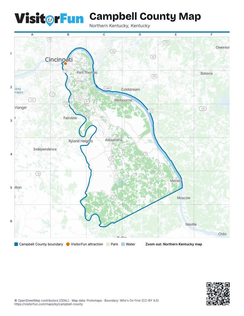
Street index of Campbell County
Each street on the sheet and the grid squares it crosses.
- Circle FreewayC2
- AA HighwayB3, C3, D3, D4, E4, E5
- Alexandria PikeB2, C2, C3, C4, C5, C6, D6
- Licking PikeB2, B3, C3, C4
- North Grand AvenueB1, B2
- Washington AvenueB1, B2
- Monmouth StreetB1, B2
- Lowell StreetB1, B2
- West 3rd StreetB1, C2
- East 3rd StreetB1, C2
- York StreetB1
- West 5th StreetB1
- West 11th StreetB1, B2
- Dave Cowens DriveB1
- Taylor–Southgate BridgeB1
- Carothers RoadB1
- East 11th StreetB1
- Connector RoadD3
- East Martin Luther King Junior BoulevardB2
- Mary Ingles HighwayB1, C1, C2, D2, D3, D4, E4, E5
- Flagg Springs PikeD4, D5, E5
- Persimmon Grove PikeC4, D4, D5
- California Cross RoadD4, E4, D5
- Four Mile RoadC2, C3, D3
- East Alexandria PikeC3
- Johns Hill RoadB2
- North Fort Thomas AvenueB1, C1, B2, C2
- Creektrace RoadC4
- Peach Grove RoadC5, D5, D6
- Race Track RoadC5, D5
- Wesley Chapel RoadD5, E5
- Memorial ParkwayB1, C1
- East Main StreetC4, D4
- South Licking PikeC4, C5
- South Fort Thomas AvenueB2, C2
- Industrial RoadC2
- Three Mile RoadB2, C2
- Lickert RoadC4, D4
- Pooles Creek RoadC2, B3, C3
- Riley RoadC3, D3, C4
- Moock RoadB2
- University DriveB2
- Louie B. Nunn DriveB2
- 6th AvenueB1
- Nelson RoadD3
- Pavilion ParkwayB1
- South Grand AvenueB2, C2
- Smith RoadE5
- East 10th StreetB1
- West Main StreetC4
- Fairfield AvenueB1
- Martha Layne Collins BoulevardB2
- Ivor RoadE5
- Camel CrossingC4
- US 27–AA Connector RoadC3
- Al Schneider BridgeC4
- State Highway 154D6
- Washington Trace RoadD4, E4, E5
- Stonehouse RoadD3, D4
- Pond Creek RoadC4, C5
- Kenton Station RoadC5
- Tollgate RoadC3, C4
- Winters LaneC2
- Carthage RoadD4
- Oneonta RoadD3, D4
- Grandview AvenueB1, B2, C2
- Covert Run PikeB1, C1
- Taylor AvenueB1, C2
- Painter RoadD4
- New Richmond RoadD4
- Highland AvenueB2, C2
- Norse BoulevardB2
- Berry AvenueB1
- Park AvenueB1
- 4th AvenueB1
- Main StreetB1, B2, E5
- River RoadC2
- 7th AvenueB1
- Stevens Branch RoadD4
- Rossford AvenueB1, C1
- Central AvenueB1, B2
- Newman AvenueB1, B2
- Dayton PikeB1
- Chesapeake AvenueB1, D2
- East 6th StreetB1
- O’Fallon AvenueB1
- Patterson StreetB1, B2
- East 4th StreetB1
- West 12th StreetB1, B2
- West 10th StreetB1, B2
- Clover Ridge AvenueB1
- East 5th StreetB1
- West 4th StreetB1, C2
- Parkview AvenueB1, B2
- Clay StreetB1
- Donnermeyer DriveB1
- 16th StreetB1, B2
- 15th StreetB1, B2
- Orchard Terrace WestC2
- Pleasant Ridge RoadC4, C5, C6
- Clay Ridge RoadC5, C6
- Burns RoadD5
- Hissem RoadC5, C6
- Siry RoadC5, D5
- Parklake RoadC5, D5
- Fisher RoadD5, D6
- Wagoner RoadD4, D5
- Fender RoadD3
- Old Alexandria PikeC4, C5
- Fairlane RoadC6, D6
- Shaw Goetz RoadD5
- Murnan RoadC3
- Grandview RoadC4, D4
- Uhl RoadC2, C3
- Nine Mile RoadD3
- Shaw Hess RoadD4, D5
- Rifle Range RoadC3, B4, C4
- Poplar Ridge RoadC3, D3
- Woeste RoadC4, C5
- Lees RoadC5
- Lower Tug Fork RoadC3
- Tippenhauer RoadB3, C3
- Daniels RoadD5, E5
- Gilbert Ridge RoadC3, C4
- Schababerle Hill RoadD5, E5
- Wolf RoadB5, C5
- Dodsworth LaneC2, C3
- Poplar Thicket RoadC4
- Dead Timber RoadD4, E4
- Ten Mile RoadD3
- Eight Mile RoadD2, C3, D3
- Waterworks RoadB1, C1
- Morning View RoadC6
- Arcadia BoulevardC3
- Boone Smith RoadC5
- Upper Tug Fork RoadC3
- Truesdell RoadD3
- Nagel RoadC5, C6
- Harrisburg Hill RoadC5
- Vineyard LaneD3
- Flatwoods RoadD5
- West Miller RoadC4
- Manhattan BoulevardB1
- Craft RoadD4, C5
- Terry Jolly WayC5
- Saratoga StreetB1
- Indian Trace RoadB4, C4
- Jerry Wright RoadC4
- Barrs Branch RoadD4
- Ridgewood DriveD4
- Phillips RoadC4, C5
- Hidden Valley RoadB3, C3
- Maddox RoadC4
- Visalia RoadC4, C5
- Riverboat RowB1
- Dry Creek RoadB3, C3
- Owl Creek RoadC2, C3
- 5th AvenueB1, C2
- Echo HillsC4
- Aulick RoadC6
- Bezold RoadD5
- Lincoln RoadB1, B2
- Tarvin RoadC5
- Demossville RoadC6
- Steffen RoadC4
- Plum Creek RoadD6
- Reis Ridge RoadD5
- Bakerfield RoadC5
- Muinn RoadC6
- Bentwood Hills DriveB2
- Vine StreetB1, B2
- Center StreetB1, B2, C4
- 3rd AvenueB1
- Parkside DriveC5
- Brookwood DriveC4, D4
- Kentucky DriveB2
- Skyline DriveC2
- Sunset DriveB2, C3
- Upper Lick Branch RoadD3, D4
- Losey RoadC4
- Koehler RoadD5, E5
- Blossom LaneB2
- Gloria Terrell DriveB3
- Gubser Mill RoadD5
- Grey Stable LaneB2
- Reitman RoadC3
- Maple AvenueB1, B2, C2
- Mystic RoseD3
- Branch Lick RoadD3, D4
- Weaver LaneC2, C3
- Dayton AvenueB1
- Smith Hiteman RoadC5
- Darlington RoadC3
- Columbia StreetB1
- Fausz RoadD3
- Haubner RoadD5
- Heck RoadC3
- Breckenridge RoadC3, C4
- Woodland Hills DriveB2
- Lafayette AvenueB1, B2
- Mallard DriveC4
- Enzweiler RoadC3
- Ripple Creek RoadC3
- Crossroads BoulevardC3
- Eagle ViewC5
- Walnut StreetB1
- Knollwood DriveB2
- Bluegrass AvenueC1, B2, C2
- Darlington Creek DriveC5
- Summerlake DriveC4
- Isabella StreetB1, B2
- Constable DriveC4
- Devonshire DriveC3
- Brighton StreetB1, B2
- Blangey RoadC2
- Kohls RoadD3
- West Low Gap RoadC3
- Tower Hill RoadB1, C1
- Wish RoadD5
- Yelton Hill RoadD6
- Van Voast AvenueB1
- Linden AvenueB1, C2
- Ridgepointe DriveB3, C3
- Granite Spring DriveC3
- Ward AvenueB1
- Baynum Hill RoadE5
- Kenton DriveB2
- Viewpoint DriveC3
- Orchard LaneB1, B2, C3, C4
- Ridge Hill DriveB2, B3
- Saddle Ridge TrailD4
- Bob White LaneD4
- Campbell DriveB2
- Riverview DriveC6
- Madonna LaneC2, C3
- Burnet RidgeC1
- Burger RoadD3
- East 2nd StreetB1, C2
- Joyce AvenueB2
- Summer Hill RoadD4, E4
- Gary LaneC2
- East 7th StreetB1
- Orchard StreetB1, B2
- Orchard TerraceC2
- Foote AvenueB1
- Washington StreetC3, C4, E4
- Gunkel RoadD3
- Marie DriveC4
- East 8th StreetB1
- Liberty StreetB1, B2
- Shadow Lake DriveC3
- Lick Hill RoadD4
- Lincoln AvenueD2
- 8th AvenueB1
- Riverpointe DriveB1
- Becks RoadD3
- East 9th StreetB1
- Newberry RoadD4
- Gould AlleyB1
- Harrison AvenueB1, B2
- Riverside ParkwayC1
- Linden RoadB2
- Stonegate DriveC4
- Main AvenueB2, C2
- Solitude LaneD3, D4
- John Miller RoadC4
- Sandstone RidgeB3, C3
- Redstone RoadD4
- East Low Gap RoadC3
- Highland Meadows CircleB2, B3
- Chalk RoadD3
- Lake Park DriveC4
- West 9th StreetB1
- Ervin TerraceB1
- Fairbanks LaneB2
- 2nd AvenueB1
- Meadow LaneB1, B2, B3, C3
- Messmer Hill RoadC3
- Dobbling LaneD3
- Walnut Park DriveC3
- Anderson LaneC2, D2
- Herringer RoadC5
- Poplar StreetB1, B2
- Hillview RoadC5
- Ann StreetB1
- Mayfield AvenueB1, B2
- Latonia AvenueC2, D2
- Steel Plant RoadB2
- Henderson LaneE4
- Saint Johns LaneB3
- Koerner LaneC5
- Overton StreetB1
- Union StreetB1, E4
- West 7th StreetB1
- New Linden RoadB2
- Ohio AvenueB1
- Morscher RoadC2
- Boone StreetB1, C2
- Cryer RoadD4
- Putnam StreetB1
Things to do on the Campbell County map
Places on the map
- A. J. Jolly County Park
- A. J. Jolly Golf Course
- Alexandria
- Alexandria Community Park
- Alexandria Fairgrounds
- Bellevue
- Bezold Pines
- Boothe Residential Village
- Brookstone Crossing
- California
- Campbell County
- Campbell County High School
- Campbell County Lake
- Castellini
- Claryville
- Cold Spring
- Continental Building Products
- County Square
- Crestview
- Dayton
- Doyle's Country Club
- Evergreen Cemetery
- Forest Ridge
- Fort Thomas
- Hickory Sticks Golf Club
- Highland Country Club
- Highland Heights
- Highland Hills Park
- Ipsco Tubulars
- Licking River
- Maxim Crane Works
- Melbourne
- Memorial Pointe
- Mentor
- Newport
- Riverside Marina
- Silver Grove
- Southgate
- Tower Park
- Wilder
Next to Campbell County
- Batavia
- Bromley
- Chilo
- Cincinnati
- Coldstream
- Covington
- Erlanger
- Fairview
- Independence
- Latonia Lakes
- Ludlow
- Moscow
- Neville
- Owensville
- Ryland Heights
- Walton
© OpenStreetMap contributors (ODbL) · Map data: Protomaps · Boundary: Who's On First (CC-BY 4.0)