

Kentucky map
Hardin County map
About 112,826 people live here (Census Bureau, 2024 estimate). The sheet's index lists 300 streets; Sonora Hardin Springs Road, Salt River Road and East Main Street cross the most grid squares. Things to do inside the boundary: General George Patton Museum of Leadership.
Open the map (PDF, US Letter)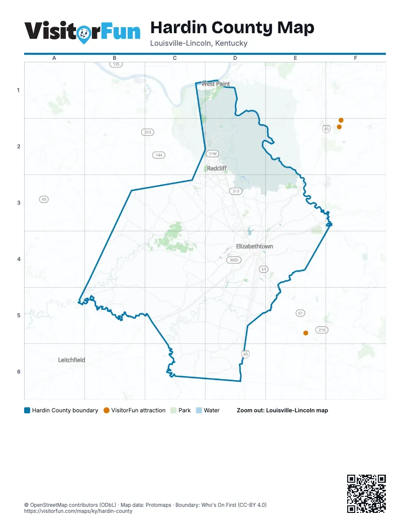
Street index of Hardin County
Each street on the sheet and the grid squares it crosses.
- Western Kentucky ParkwayD4, C5, D5
- Bluegrass ParkwayE3, F3, E4
- Kentucky TurnpikeE3
- Joe Prather HighwayC3, D3, E3
- Leitchfield RoadC4, D4, C5
- Patriot ParkwayD3, D4
- New Glendale RoadD4, D5, D6
- Ring RoadD3, D4
- North Dixie HighwayD3, D4
- Lincoln ParkwayD4, E4, E5
- South Dixie BoulevardD2, D3
- Bardstown RoadE3, E4
- Elizabethtown BypassD4
- Dixie Highway NorthC2, D2
- South Dixie HighwayD4, D5, D6
- Dixie HighwayC1, D1, C2
- North Mulberry StreetD4, E4
- Dixie Highway EastD4, D5
- Knox AvenueC2, D2, C3
- North Dixie BoulevardD2
- South Ring RoadD4
- Bullion BoulevardD2
- Veterans Memorial HighwayD2
- South Mulberry StreetD4
- East Dixie AvenueD4
- Woodland DriveD3, D4
- West Dixie AvenueD4
- Cardinal DriveD2, D4
- North Walnut StreetD6
- South Walnut StreetD6
- Dixie Highway SouthD3
- Elizabethtown RoadE3
- Sonora Hardin Springs RoadB4, B5, C5, D5
- Salt River RoadC3, B4, C4, B5
- Rineyville-Big Springs RoadB3, C3, D3
- Hardinsburg RoadB4, C4, D4
- Battle Training RoadD3, E3
- Rineyville RoadC3, D3
- Wilson RoadD1, D2
- Shepherdsville RoadD2, D3
- South Wilson RoadD2, D3
- Sportsman Lake RoadD4, D5
- Glendale Hodgenville RoadD5, E5
- Roundtop RoadE4, E5
- Millerstown RoadC6, D6
- West Lincoln Trail BoulevardD2, C3, D3
- North Logsdon ParkwayD2
- Hodgenville RoadD4, E4
- Glendale Hodgenville Road WestD4, D5
- South Logsdon ParkwayD2, D3
- Hutcherson LaneD3, D4
- Youngers Creek RoadE3, F3
- Main StreetD1, C2, D5
- North Miles StreetD3, D4
- Vine Grove RoadD2, C3
- East Main StreetC3, D3, D4, D5
- Crume RoadC3
- North Wilson RoadD2
- Elm RoadD2, D3
- West Vine StreetD2, D3
- Hargan RoadC3
- High StreetC3, D4, D5, D6
- Grayson StreetD6
- Highland AvenueC3, D3
- West Main StreetC3, D4
- East Western AvenueD5
- Brown StreetD2, C3
- Colesburg RoadE3
- Knox BoulevardD2
- West A Jenkins RoadD3
- Church StreetC3, D5, D6
- Medical Center DriveD3
- North Beech StreetD5
- East Vine StreetD2
- Old Elizabethtown RoadE4
- Flaherty RoadC3
- Saint John RoadB3, C3, C4, D4
- Long Grove RoadC3, C4, C5, D5
- Flint Hill RoadD5, C6, D6
- Main Range RoadD1, D2
- Valley Creek RoadD4, E4
- Bacon Creek RoadD4, C5, D5
- 7th Armored Division RoadD2, D3
- Wooldridge Ferry RoadD3, E3
- Pierce Mill RoadB4
- North Grandview Church RoadB3, B4
- Deckard School RoadD3
- Porter River RoadD1, D2
- Copelin RoadC5, C6
- Mount Olive RoadB4
- Hill StreetD2, D3, D4
- Nolin RoadD5
- Cash RoadC6
- Upton-Melrose RoadD6
- Saint John Church RoadD3, C4, D4
- Solway Meeting RoadB5
- Bethlehem Academy RoadC4, D4
- Blueball RoadC3
- Red Hill RoadC2, D2
- Gilead Church RoadD5
- South Woodland DriveD2, D3
- North Black Branch RoadD4
- White Mills Glendale Road WestC5, D5
- Fuller RoadC4, D4
- Salem School RoadC3
- Eisenhower AvenueD2
- Mack Thomas RoadE4
- Baker RoadD1, C2, D2
- Spearhead Division AvenueD2
- Rineyville School RoadC3, D3, C4
- Robinbrooke BoulevardD3, D4
- Rogersville RoadD3
- Brandenburg Station RoadC2, D2
- Old Ironsides AvenueD2
- Franklin Crossroads RoadC4
- Shelton RoadD3, D6
- College StreetD4, D5, D6
- Peterson DriveD4
- East Lincoln Trail BoulevardD2
- Pear Orchard Road NorthwestD3
- Chaffee AvenueC2, D2
- Gold Vault RoadD2
- Brave Rifles Regiment AvenueD2
- Dixie StreetD2
- North Main StreetD4
- College Street RoadD4
- 11th AvenueD2
- Knox StreetD2
- Veterans WayD3
- Frazier RoadD2
- Martin RoadC3
- Muldraugh Magazine RoadC1, D1, C2, D2
- Park RoadD2
- Lewis LoopD6
- North Woodland DriveD2
- State StreetD2, D4
- Brackett Cemetery RoadD6
- South Atcher StreetD2, D3
- Louisville Nashville TurnpikeD1
- Cecil AvenueD4
- Millcreek RoadD3
- Methodist StreetD4
- Highland DriveD2
- Walmart WayD2
- Buford LaneD3
- Ray RoadB4
- South Beech StreetD5
- West Western AvenueD5
- Big Spring RoadB3
- Berkley CourtD2
- Rineyville Big Spring RoadB3
- Globe StreetD2
- South Main StreetD4
- Robbie Valentine DriveD2
- Layman LaneD4
- Spearhead Division Avenue YD2
- Kieta WayD2
- Stithton CircleD2
- Brave Rifles Regiment Avenue YD2
- Ova A Wright RoadB4
- Gray RoadE4
- Bonnieville-Lone Star RoadD6
- 745th Tank Battalion RoadE2, D3, E3
- Constantine RoadB4
- Miller RoadE3, E4
- Gaither Station RoadD4, D5
- Middle Creek RoadE4
- New Salem Church RoadB3, C3
- Springfield RoadD4, E4
- Berrytown RoadC3
- Long Hollow RoadB3
- Dry Ridge RoadB5
- Meeting Creek RoadC5
- Kelly RoadE3
- Webb Mill RoadC5
- Upton RoadD2, D5, D6
- Laurel Ridge RoadB4
- Lower Colesburg RoadE3
- Horn RoadC4
- Tabbs Hollow RoadB5, C5
- Blueball Church RoadC3, C4
- Star Mills RoadC5
- Upper Colesburg RoadE3
- Center Point RoadC5
- Melrose RoadC5, C6
- Thomas RoadD3, D4
- Stovall RoadE3
- Nacke Pike RoadC4
- Star Mills Eastview RoadC5
- Lucas Grove RoadC6, D6
- Red Mill RoadE4
- Akers School RoadC6
- Silver Mine RoadC5, D5
- Yates Chapel RoadC4
- Walter Boone RoadD3
- Cann School LaneB4, C4, B5
- West Rhudes Creek RoadD4
- Needham RoadB4
- Richardson RoadC4, C5
- South Boundary RoadD2, D3
- Eastview RoadC5
- South Grandview Church RoadB4
- Ford HighwayE4
- Locust Grove RoadE4
- Pear Orchard RoadD3, D4
- Wonderland Cavern RoadC5
- Fred Burns RoadD3
- West Park RoadD4
- Hayden School RoadD4
- South Black Branch RoadC4, D4
- White Mills Glendale Road EastD5
- Poorman Range RoadD2
- Bewley Hollow RoadD3
- Wooden LaneE3
- Horseshoe Bend RoadD5
- Tunnel Hill RoadD3, E3, E4
- Shipley RoadB4, C4
- Old Kentucky TurnpikeD1
- Brumfield Range RoadD2
- Mud Splash RoadD4, D5
- Smith Mill RoadD5
- Brizendine LaneC3
- Estrada AvenueD2
- Jaggers RoadD5
- Cecilia Smiths Mill RoadD4
- Hogan RoadC5, C6
- Limp RoadB5
- Shady Bower LaneD5
- 7th Armor Division Cut-Off RoadD2
- Western School RoadB4, B5
- North Pleasant Hill RoadD6
- Audubon TraceE3, E4
- Duggin Switch RoadC3, D3
- Lee School RoadC5, C6
- Mercer LaneC1, D1
- Harris School RoadC3, C4
- Rock Creek RoadC5
- George Tabb RoadD6
- Hansborough RoadC4
- Howevalley RoadC4
- Bratcher LaneB3, C3
- Maple RoadC2, D2
- Mackey RoadD5
- Puckett RoadD5
- Plainview RoadC4, C5
- Summit RoadC5
- Jenkins RoadC3
- Johnson RoadB4, C5
- Hillcreek DriveE4
- Stewart RoadE3
- Masters LaneD3
- 9th Cavalry Regiment AvenueD2
- Optimist RoadE3
- Tabb RoadC4
- Freeman Lake RoadD3, D4
- Sutzer Creek LaneC4
- Adkins RoadB3
- Skyline DriveD3, D4
- Old Sonora RoadD5
- Overall Phillips RoadD4
- Nicholas Springs CourtD4
- Crisp RoadC4, D4
- Quarry RoadD6
- West Bryan RoadD3
- Mount Zion RoadD3
- Buckles RoadC5
- Blackjack RoadD3
- Tom Duvall LaneB4, C4
- Nathans LaneB5
- Vertrees Church LaneB4
- Cave RoadC5
- Sycamore RoadD3
- Hawkins DriveD2, D4
- Glascock LaneB5
- Pickerell LaneC3
- Steeles Range RoadD2
- Lincoln DriveE3
- West Crocus DriveD2, D3
- Cowley Crossing LaneD3
- Sonora Nolin RoadD5
- West Yates Chapel RoadC4
- Safari TrailC2, D2
- Kings WayD4
- Chestnut Grove RoadE3
- Hoover Hollow RoadB5, C5
- Pine Valley DriveD3
- Commerce DriveD3, D4, E4
- Lambert LaneC5
- Miles Hill RoadC5
- Summit-Eastview RoadC5
- Smallwood LaneB4
- Hornback LaneD6
- Cecilia RoadD4
- Tunnel Hill Church RoadD3, E3
- Williams LaneB4, D4
- Lafollette RoadE4
- Westport RoadD4
- Meredith RoadC3
- Foxfire RoadD3
- Otter Creek RoadC3
Things to do on the Hardin County map
Places on the map
- Addington Field / Elizabethtown Regional Airport
- American Legion Park
- Armor Memorial Park
- Auto Glass Drive
- Baptist Health Hardin
- Bland Knobs
- Blueball Hill
- Brooks Field Parade Ground
- Buffalo Lake
- Burkhead School
- Canby Hill
- Cecil Hill
- Central Hardin High School
- Eastman Park
- Eastview Post Office
- Elizabethtown
- Elizabethtown Nature Park
- Elizabethtown Sports Park
- Etown RV Park
- Fort Duffield Park and Historic Site
- Fort Knox
- Fort Knox Quarry (#538)
- Freeman Lake
- Freeman Lake Park
- Lindsey Golf Course
- Lower Douglas Lake
- Petro Stopping Centers
- Radcliff
- Sander Spring Lake
- Sonora
- Sportsman Lake
- Stephensburg Lake
- Towne Mall
- Upper Douglas Lake
- Upton
- Valley Creek Reservoir
- Vernon Douglas State Nature Preserve
- Vine Grove
- West Point
- White Mills Christian Camp
Next to Hardin County
- Leitchfield
© OpenStreetMap contributors, Open Database License, openstreetmap.org/copyright · Map data: Protomaps · Boundary: Who's On First (CC-BY 4.0); Quattroshapes (CC BY 2.0)