

Kentucky map
Louisville-Lincoln map
The sheet's index lists 37 highways; US 150, I-65 and US 60 cross the most grid squares. Things to do inside the boundary: Abraham Lincoln Birthplace National Historical Park, Bernheim Forest and Arboretum and Big Four Bridge. Also on it: Bardstown, Crestwood and Elizabethtown.
Open the map (PDF, US Letter)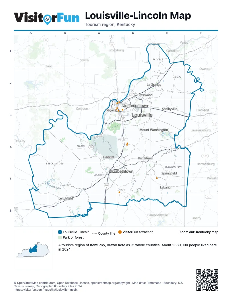
Highway index of Louisville-Lincoln
Each highway on the sheet and the grid squares it crosses.
- I-64C3, D3, E3, F3
- I-65C4, C5, C6, D3, D4
- I-71D2, D3, E1, E2
- I-264C3, D3
- I-265D2, D3
- US 31ED3, D4
- US 31WC3, C4, C5
- US 60A4, B4, B5, C3, C4
- US 68E5, E6
- US 150C3, D3, D4, E4, E5, F5
- KY 44E3
- KY 55E3, E5, E6
- KY 61C5, D3, D5
- KY 79B4, B5
- KY 86B4
- SR 135B4
- KY 144A4, C4
- KY 155D3, E3
- KY 210D5, D6
- KY 245D4
- KY 248E3, E4
- KY 259B5
- KY 313B4, C4, D4
- KY 333B4
- KY 361C4
- KY 412E6
- KY 438E5
- KY 555E4, E5
- KY 584D5, D6
- KY 605E4
- KY 841C3, D2, D3
- KY 1230C3
- KY 1531D3
- KY 1618D5
- KY 1934C3
- KY 2154E5
- KY 3005C5
Things to do on the Louisville-Lincoln map
- Abraham Lincoln Birthplace National Historical Park
- Bernheim Forest and Arboretum
- Big Four Bridge
- Cave Hill National Cemetery
- Central Park (Louisville)
- Cherokee Park
- Churchill Downs
- E. P. "Tom" Sawyer State Park
- Frazier Kentucky History Museum
- General George Patton Museum of Leadership
- Iroquois Park
- James B. Beam Distilling Co.
- Jefferson Mall
- Jeffersontown Historical Museum
- Kentucky Derby Museum
- Kentucky Kingdom
- Kentucky Science Center
- Louisville Mega Cavern
- Louisville Slugger Museum & Factory
- Louisville Water Tower
- Louisville Zoo
- Maker's Mark Distillery
- Muhammad Ali Center
- My Old Kentucky Home State Park
- Oscar Getz Museum of Whiskey History
- Portland Museum
- Shawnee Park
- Speed Art Museum
- Taylorsville Lake State Park
- The Louisville Palace
- Thomas Edison House
- Zachary Taylor National Cemetery
Places on the map
- Bardstown
- Crestwood
- Elizabethtown
- Jeffersontown
- La Grange
- Lebanon
- Leitchfield
- Louisville
- Mount Washington
- Radcliff
- Shelbyville
- Shively
- Springfield
Next to Louisville-Lincoln
- South Indiana
- Southeast Indiana
- Southwest Indiana
- Bluegrass map
- Cave Region map
- Green River map
- Northern Kentucky map
- Southern Kentucky Lakes and Rivers map
© OpenStreetMap contributors, Open Database License, openstreetmap.org/copyright · Map data: Protomaps · Boundary: U.S. Census Bureau, Cartographic Boundary Files 2024