

Kentucky road map
I-71 in Kentucky map
I-71 is about 94 miles in Kentucky. It has 38 exits, from Exit 6 at mile 0 to Exit 192 at mile 93. It meets 43 highways; US 42, US 127 and KY 146 meet it in the most grid squares.
Open the map (PDF, US Letter)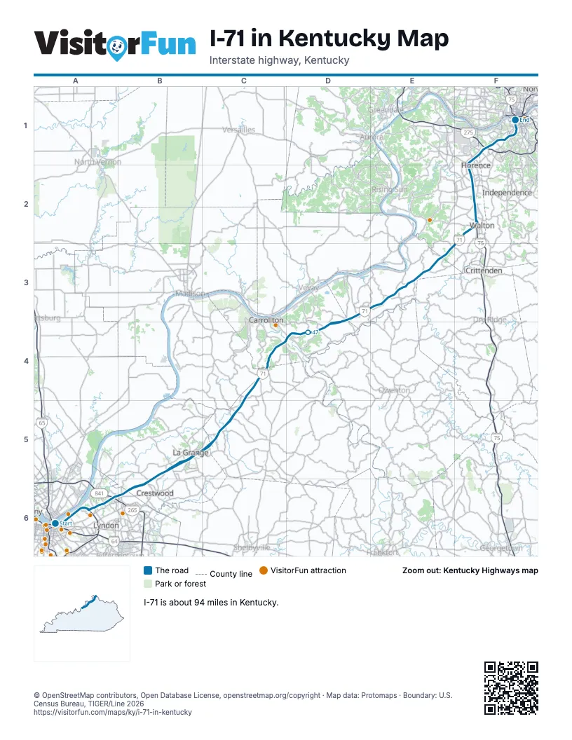
Exits on I-71 in Kentucky
Each exit in mile order, with its grid square.
- Exit 6mile 0, A6
- Exit 1C/1Bmile 0, A6
- Exit 7mile 0, A6
- Exit 1Amile 1, A6
- Exit 2mile 2, A6
- Exit 5mile 6, A6
- Exit 9Amile 9, A6
- Exit 35Bmile 9, A6
- Exit 35Amile 9, A6
- Exit 9Bmile 10, B6
- Exit 14mile 15, B6
- Exit 17mile 17, B5
- Exit 18mile 18, B5
- Exit 20mile 21, B5
- Exit 22mile 22, B5
- Exit 28mile 28, C5
- Exit 34mile 33, C5
- Exit 43mile 42, C4
- Exit 44mile 44, D4
- Exit 55mile 55, D3
- Exit 57mile 56, D3
- Exit 62mile 61, E3
- Exit 72mile 71, E3
- Exit 77mile 76, F2
- Exit 173mile 76, F2
- Exit 175mile 79, F2
- Exit 178mile 82, F2
- Exit 180mile 83, F2
- Exit 180-Amile 84, F2
- Exit 181mile 84, F2
- Exit 182mile 85, F1
- Exit 184mile 87, F1
- Exit 185mile 88, F1
- Exit 186mile 89, F1
- Exit 188mile 91, F1
- Exit 189mile 91, F1
- Exit 191mile 93, F1
- Exit 192mile 93, F1
Highways I-71 meets
Each highway it meets and the grid squares where they meet.
- I-64A6
- US 42A6, F1, F2
- I-265A6
- KY 841A6
- KY 1694B6
- KY 329B6
- KY 146B5, C5
- KY 53B5
- KY 712B5
- KY 153C5
- KY 1606C5
- KY 157C5
- US 421C5
- KY 2844C4
- KY 55C4
- KY 389C4
- KY 227D4
- KY 1112D4
- KY 1204D4
- KY 184D3
- KY 47D3
- KY 465D3, E3
- KY 35D3
- KY 455E3
- US 127E3, F1, F2
- KY 562E3
- KY 16E3
- KY 2964E3
- KY 14E3
- KY 1292F2
- I-75F2
- KY 338F2
- KY 536F2
- KY 2953F2
- KY 18F2
- KY 1017F1
- KY 236F1
- I-275F1
- KY 371F1
- US 25F1
- KY 1072F1
- KY 1120F1
- KY 8F1
Towns along I-71 in Kentucky
In mile order, with the grid square of each.
- Louisvillemile 0, A6
- Louisville/Jefferson County metro government (balance)mile 3, A6
- Mockingbird Valleymile 3, A6
- Rolling Fieldsmile 3, A6
- Indian Hillsmile 3, A6
- Glenviewmile 5, A6
- Glenview Hillsmile 6, A6
- Windy Hillsmile 6, A6
- Crossgatemile 6, A6
- Bancroftmile 7, A6
- Green Springmile 7, A6
- Goose Creekmile 8, A6
- Broeck Pointemile 8, A6
- Ten Broeckmile 9, A6
- Coldstreammile 12, B6
- Orchard Grass Hillsmile 12, B6
- Crestwoodmile 15, B6
- Bucknermile 16, B5
- La Grangemile 20, B5
- Campbellsburgmile 33, C5
- Spartamile 55, D3
- Glencoemile 61, E3
- Veronamile 69, E3
- Waltonmile 75, F2
- Florencemile 80, F2
- Unionmile 80, F2
- Elsmeremile 86, F1
- Erlangermile 87, F1
- Edgewoodmile 88, F1
- Villa Hillsmile 88, F1
- Crestview Hillsmile 88, F1
- Fort Mitchellmile 89, F1
- Lakeside Parkmile 89, F1
- Crescent Springsmile 89, F1
- Fort Wrightmile 91, F1
- Covingtonmile 91, F1
- Park Hillsmile 92, F1
- Newportmile 94, F1
- Ludlowmile 94, F1
Things to do on the I-71 in Kentucky map
© OpenStreetMap contributors, Open Database License, openstreetmap.org/copyright · Map data: Protomaps · Boundary: U.S. Census Bureau, TIGER/Line 2026