

Louisiana map
Baker map
About 12,147 people live here (Census Bureau, 2024 estimate). The sheet's index lists 220 streets; Main Street, Groom Road and Lavey Lane cross the most grid squares. Also on it: Baker High School, Baker Post Office and Hillcrest Gardens Cemetery.
Open the map (PDF, US Letter)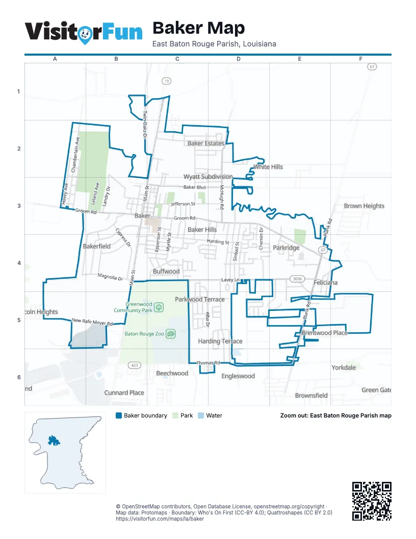
Street index of Baker
Each street on the sheet and the grid squares it crosses.
- Heck Young RoadB1
- Old Baker Zachary RoadB1
- Twin Oaks DriveB1, B2, C2
- Main StreetC1, C2, B3, C3, B4, B5
- Scotlandville-Zachary HighwayC1
- Chamberlain AvenueA2, A3
- Clark StreetA2
- College AvenueA2, A3
- Hovey AvenueA2, A3
- Morehouse StreetA2
- Taylor StreetA2
- Boxwood DriveB2, B3
- Landry DriveB2, B3
- Leland AvenueB2, B3
- Ashland StreetC2, D2
- Ben Williams LaneC2
- Bodo DriveC2
- Burgess DriveC2, D2
- Carolyn DriveC2, C3
- Debra DriveC2, C3
- East Azalea AvenueC2, C3
- Gibbens Payne AvenueC2, D2
- Greenwood LaneC2, D2
- Heath DriveC2, D2
- Jacquelyn DriveC2
- Manchester DriveC2
- Manhatten DriveC2
- North Azalea AvenueC2
- Singletary DriveC2
- Trotter DriveC2
- West Azalea AvenueC2, C3
- Wimbish DriveC2, D2
- Yvonne DriveC2, D2
- Evans DriveD2
- Hickory DriveD2
- McHugh RoadD2, D3
- PearceD2
- Scott StreetD2
- Shere DriveD2
- Tamarak DriveD2
- Tristian AvenueD2
- West Evans DriveD2
- Felton StreetA3
- Groom RoadA3, B3, C3, D3, E3, E4
- John MarksA3
- Mitchell StreetA3
- Perkins StreetA3
- Adams StreetB3, C3
- Allen CourtB3
- Camelia AvenueB3, B4
- Center StreetB3, B4
- Cypress DriveB3, B4
- Cypress Wood DriveB3
- Garfield StreetB3
- Hays StreetB3
- Jackson StreetB3, C3
- Jefferson StreetB3, C3, D3
- Louisiana AvenueB3
- Mississippi StreetB3, C3
- North Magnolia DriveB3, B4
- Parkway DriveB3
- Polk StreetB3, C3
- Ray Weiland DriveB3, B4
- Roosevelt StreetB3
- Southwest DriveB3
- Texas AvenueB3
- Truman StreetB3, C3
- Washington StreetB3, C3
- Wilson StreetB3
- Alabama StreetC3
- Baker BoulevardC3, D3
- Daniels StreetC3, C4
- Davis StreetC3
- Epperson StreetC3, C4
- Ewell BoulevardC3
- Florida AvenueC3
- Gwendolyn DriveC3
- Johnston StreetC3, C4
- Mc Vea StreetC3
- Monroe StreetC3
- Myrtle StreetC3, C4, D4
- Nichols StreetC3
- Patricia StreetC3, C4
- Plaza DriveC3
- Robinson StreetC3
- Whitehead StreetC3, C4
- Winside DriveC3, D3
- Barrington DriveD3, D4
- Bentley DriveD3
- Buffet StreetD3, D4
- Chemin DriveD3, D4, E4
- Don AvenueD3
- Georgia StreetD3, D4
- Hazeloak DriveD3
- Husband StreetD3, C4
- Kimberlin DriveD3
- SevilleD3
- Sherron AvenueD3, D4
- Shilo DriveD3, D4
- Sinbad StreetD3, D4
- Sunshine DriveD3, D4
- Lake Mary DriveE3, E4
- Plank RoadE3, E4, E5, E6
- Woodward DriveE3, E4, E5
- South Magnolia DriveA4, B4
- West Magnolia DriveA4, B4
- Arkansas StreetB4
- Buchanan StreetB4, C4
- Coolidge StreetB4, C4, D4
- Day DriveB4
- Grant StreetB4, C4
- Harrison StreetB4, C4
- Lavey LaneB4, C4, D4, E4, F4
- North Day DriveB4
- South StreetB4
- Van Buren StreetB4, C4
- Adair AvenueC4
- Alba DriveC4, C5
- Brantley DriveC4, C5
- Breckenridge DriveC4, D4
- Buffwood DriveC4
- Cayuga DriveC4, C5
- Chaleur DriveC4
- Chapeau DriveC4, D4
- Charry DriveC4
- Douceur DriveC4
- East Buffwood DriveC4
- Fausse DriveC4, D4
- Fourchon DriveC4, D4
- Harding StreetC4, D4
- Parklan DriveC4
- Paulfor StreetC4
- Rabel DriveC4
- Rue de Valeur PlaceC4
- Rue SplendeurC4
- Rue Von HeurC4
- Sandy DriveC4
- South Johnston StreetC4
- West Buffwood DriveC4
- West Chapeau DriveC4
- West Fausse DriveC4
- Burras AvenueD4
- Byfaul AvenueD4
- Celester DriveD4
- Charles AvenueD4
- Circle DriveD4
- Crosley DriveD4
- East Tigre Chenes CourtD4
- Fullerton AvenueD4
- Loflin AvenueD4
- Longvue DriveD4, D5
- Maureen DriveD4
- Meadows BoulevardD4
- Morvant RoadD4, D5
- O'Callagham LaneD4, E4
- Palladium CircleD4
- Rue JenniferD4, E4
- Rue NicoleD4, E4
- Sandra DriveD4
- Shilo StreetD4
- Sunshine RoadD4, D6
- West Holden CourtD4
- West Shilo DriveD4
- West Tigre Chenes CourtD4
- Weston AvenueD4
- Balm StreetE4
- Bethany DriveE4, E5
- Biscayne StreetE4
- Blairstown DriveE4, E5
- Chester DriveE4
- Chipley StreetE4
- Clermont StreetE4
- Cody DriveE4
- East Myrtle AvenueE4
- Felicity DriveE4, F4, E5
- Hope StreetE4
- Molino DriveE4
- Oak Bend DriveE4, E5
- Paola StreetE4
- Pettit RoadE4, F4
- Rue MichelleE4
- West White Bayou DriveF4
- Leisure RoadA5, B5
- New Rafe Meyer RoadA5, B5
- Gibbens RoadB5
- Ronaldson RoadB5
- Scotland AvenueB5
- Algoa AvenueC5
- Alief AvenueC5
- Anton AvenueC5, D5
- Azie AvenueC5
- Brant DriveC5
- Cadiz DriveC5
- Daveco StreetC5
- Ector DriveC5
- Hico DriveC5
- London DriveC5
- Melban StreetC5
- Amerest AvenueD5
- Bachman CourtD5
- Canova CtD5
- Driftwood DriveD5, D6
- Ironwood DriveD5
- Middlewood DriveD5, D6
- North Morvant PlaceD5
- Northwood DriveD5
- South Morvant PlaceD5
- Sprucewood CourtD5
- Teakwood DriveD5, D6
- Wedgewood DriveD5, D6
- West Morvant PlaceD5
- Davis DriveE5
- Furr LaneE5
- Gayden AvenueE5
- Stoneview AvenueE5
- Thomas RoadC6, D6, E6
- Arena DriveD6
- Engleswood DriveD6
- Troy StreetD6
- Comite DriveE6
Places on the map
- Baker Alternative School
- Baker City Hall
- Baker Fire Department Station 20
- Baker Fire Department Station 21
- Baker High School
- Baker High School Auditorium
- Baker Middle School
- Baker Park
- Baker Police Headquarters
- Baker Post Office
- Baker Presbyterian Church
- Baker Recreational Center
- Bakerfield Elementary School
- Bethany Christian School
- Chamberland Park
- DnD Beauty Bar
- Executive Inn And Suites Baker
- First United Methodist Church of Baker
- Harding Park
- Harding Street Baptist Church
- Heritage Museum & Cultural Centre
- Hillcrest Gardens Cemetery
- Impact Charter School
- Jefferson Park
- Leland College
- McDonald's
- Mount Vernon Church Number 2
- Myrtle Park
- Northside Baptist Church
- Park Ridge Elementary School
- Redeemer Lutheran Church
- Tristian Park
- Walmart Auto Care Center
- Walmart Supercenter
- Walmart Vision Center
- Western Inn-Baker
- Woodforest National Bank
Next to Baker
- Beechwood
- Bolwood Acres
- Brentwood Place
- Brown Heights
- Brownsfield
- Cunnard Place
- Ellen Place
- Engleswood
- Green Gate
- Harding Heights
- Holiday Acres
- Kings Estates
- Kingston Estates
- Lincoln Heights
- Maryland Heights
- North Baker Park
- Rolling Acres
- White Hills
- Yorkdale
© OpenStreetMap contributors, Open Database License, openstreetmap.org/copyright · Map data: Protomaps · Boundary: Who's On First (CC-BY 4.0); Quattroshapes (CC BY 2.0)















