

Louisiana map
East Baton Rouge Parish map
About 453,022 people live here (Census Bureau, 2024 estimate). The sheet's index lists 114 streets; Greenwell Springs Road, Airline Highway and Jefferson Highway cross the most grid squares. Things to do inside the boundary: 13th Gate Escape, Louisiana State Capitol Welcome Center and Louisiana's Old State Capitol.
Open the map (PDF, US Letter)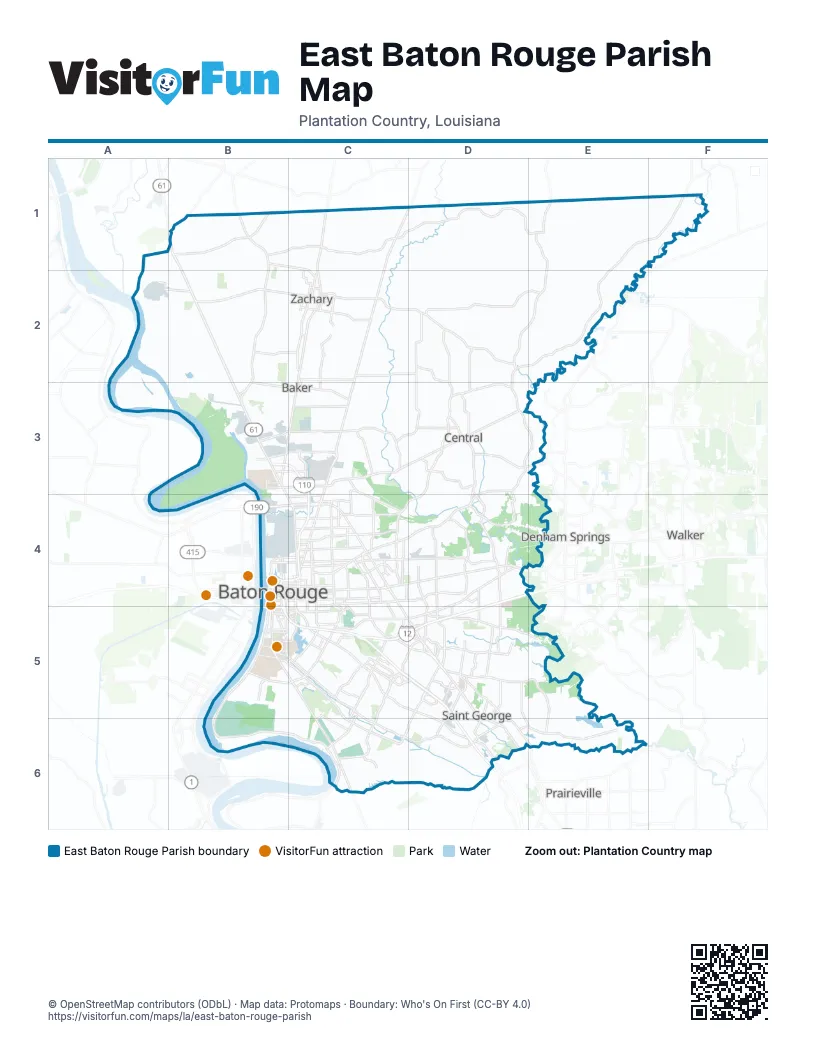
Maps inside East Baton Rouge Parish
1 map inside, from the street map of East Baton Rouge Parish down.
Street index of East Baton Rouge Parish
Each street on the sheet and the grid squares it crosses.
- Old Scenic HighwayB1, B2, B3
- Pride Port HudsonB1, C1
- Samuels RoadB1, B2, B3
- East RR AvenueC1
- Plank RoadC1, C2, C3, C4
- Zachary-Slaughter HighwayC1, C2
- Greenwell Springs RoadE1, F1, D2, E2, D3, E3, C4, D4
- Church StreetB2, C2
- Mount Pleasant Zachary RoadB2
- Greenwell Spg Pt Hudson RoadC2, D2
- High StreetC2
- Main StreetC2, C3
- Scotlandville-Zachary HighwayC2
- Zachary Deerford RoadC2
- Joor RoadD2, D3, C4, D4
- Liberty RoadD2
- Groom RoadB3, C3
- Harding BoulevardB3, C3
- Martin Luther King, Jr. Memorial FreewayB3, C3, C4
- Scenic HighwayB3, B4, C4
- Scotland AvenueB3, C3
- Thomas RoadB3, C3
- Blackwater RoadC3
- Comite DriveC3
- Hooper RoadC3, D3
- Central ThroughwayD3, D4
- Magnolia Bridge RoadD3, E3
- Sullivan RoadD3
- Magnolia BridgeE3
- Airline HighwayB4, C4, C5, D5, D6
- Capitol Access RoadB4
- Capitol Lake DriveB4
- Chippewa StreetB4, C4
- Choctaw DriveB4, C4
- East BoulevardB4, B5
- Florida StreetB4, C4
- Government StreetB4, C4
- Martin Luther King Jr Memorial FreewayB4, C4, B5
- North 10th StreetB4
- North 3rd StreetB4
- North 4th StreetB4
- North 9th StreetB4
- North River RoadB4
- North T.J. Jemison BoulevardB4
- Saint Ferdinand StreetB4, B5
- Saint Louis StreetB4, B5
- Saint Philip StreetB4, B5
- South 10th StreetB4
- South River RoadB4, B5
- South T.J. Jemison BoulevardB4
- T.J. Jemison BoulevardB4
- Evangeline StreetC4
- Florida BoulevardC4, D4
- Goodwood BoulevardC4
- Gsu RoadC4
- Hiawatha StreetC4
- Independence BoulevardC4
- Jefferson HighwayC4, C5, D5, D6, E6
- Lobdell AvenueC4, C5
- Lobdell BoulevardC4
- North 22nd StreetC4
- North Acadian ThruwayC4
- North Foster DriveC4
- Oak VillaC4
- Oak Villa BoulevardC4
- Pocahontas StreetC4
- South 22nd StreetC4
- South Acadian ThruwayC4, C5
- South Choctaw DriveC4, D4
- South Foster DriveC4
- Central ThruwayD4
- Millerville RoadD4, D5
- North Sherwood Forest DriveD4
- O Neal LaneD4
- O'Neal LaneD4, D5
- Old Hammond HighwayD4, C5, D5
- Sharp RoadD4, D5
- Sherwood Forest BoulevardD4, D5
- West Florida Republic ParkwayD4, C5, D5
- Brightside DriveB5, C5
- Burbank DriveB5, C5, C6
- East Roosevelt StreetB5
- Gourrier AvenueB5
- Horace Wilkinson BridgeB5
- Nicholson DriveB5, C5, C6
- River RoadB5, B6, C6
- South BoulevardB5
- Thomas H Delpit DriveB5
- West Roosevelt StreetB5
- Bluebonnet BoulevardC5, D5, C6
- Drusilla LaneC5
- East Access RoadC5, D5
- Essen LaneC5
- Lee DriveC5
- Perkins RoadC5, D5, D6
- Picardy AvenueC5
- South Staring LaneC5, C6
- Staring LaneC5
- West Access RoadC5, D5
- West Lee DriveC5
- Coursey BoulevardD5
- Jones Creek RoadD5
- Lakeland Park BoulevardD5
- Pecue BoulevardD5
- Pecue LaneD5, D6
- Siegen LaneD5, C6, D6
- South Harrell's Ferry RoadD5
- South Sherwood Forest BoulevardD5
- Stumberg LaneD5
- Tiger Bend RoadD5, E5
- South Tiger Bend RoadE5, E6
- Nicholson ExtendedC6
- Highland RoadD6
- Old Jefferson HighwayE6
Things to do on the East Baton Rouge Parish map
Places on the map
- 5 East
- Agway Systems
- Airline Highway Park
- Airline Industrial Park
- Albemarle
- Amite River
- Amitech USA
- Anna Jordan Park
- Antioch Park
- Apartment Lakes
- Ardenwood
- Arlington Marketplace
- Azalea Lakes
- Baird Pond
- Baker
- Baton Rouge
- Baton Rouge Metropolitan Airport
- Baton Rouge Refinery
- Baton Rouge Zoo
- Beauregard Town
- Benton
- Blackwater Conservation Area
- Bluebonnet Swamp Nature
- Bluebonnet Village
- Boykin Brothers, LLC
- BREC Memorial Sports Complex
- Briar Place
- Briarwood Estates
- Broadmoor Shopping Center
- Brownfields
- Burbank Nature Reserve
- Burbank Soccer Fields Park
- Burden Museum and Gardens
- Capitol Lake
- Capitol View
- Castille
- Cedarcrest
- Celtic Studios
- Central
- Central Sports Park
Next to East Baton Rouge Parish
- Denham Springs
- Port Allen
- Prairieville
- Walker
© OpenStreetMap contributors (ODbL) · Map data: Protomaps · Boundary: Who's On First (CC-BY 4.0)