

Louisiana map
Monroe map
About 46,622 people live here (Census Bureau, 2024 estimate). The sheet's index lists 300 streets; Desiard Street, Jackson Street and South Grand Street cross the most grid squares. Things to do inside the boundary: Biedenharn Museum & Gardens and Chennault Aviation and Military Museum.
Open the map (PDF, US Letter)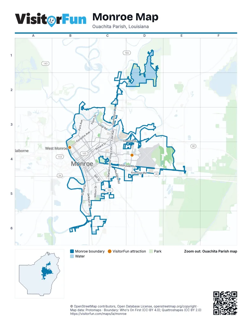
Street index of Monroe
Each street on the sheet and the grid squares it crosses.
- Sterlington RoadC2, C3, C4
- Martin Luther King Jr DriveC4, C5
- Desiard StreetC3, D3, B4, C4, D4
- Jackson StreetB4, B5, C5, C6
- Louisville AvenueB4, C4
- North 5th StreetB4
- United States Highway 165C2
- North 6th StreetB4
- Ouachita AvenueB4, C4
- Lea Joyner Memorial ExpresswayB4
- Calypso StreetB4, C4
- Layton AvenueB4, C4
- Forsythe AvenueB3, C3, B4
- Millhaven RoadC4, D4, E4
- Kansas LaneD3, D4
- North 18th StreetB3, B4, C4
- Winnsboro RoadC5
- South 3rd StreetB4, C4, C5
- South 2nd StreetB4, C4, C5
- Texas AvenueB4, C4
- South 10th StreetC4, C5
- Garrett RoadD4, D5
- South 18th StreetC4
- Louise Anne AvenueB4, C4
- Forsythe BypassC3
- Airport ExpresswayC3, D3
- Catalpa StreetB4
- Hall StreetB4
- I-20 Frontage RoadC4
- East Cutover StreetB4
- Russell Sage RoadE4
- South Grand StreetB4, B5, B6, C6
- Service RoadC4, C5
- Washington StreetB4, C4
- Breard StreetC3, B4, C4
- Loop RoadB3, C3
- Park AvenueB3, B4
- Oliver RoadB3, C3, C4
- Pecanland Mall DriveC4, D4
- Powell AvenueC4
- Plum StreetC4, B5, C5
- Riverside DriveB3, B4
- North 19th StreetB3, B4, C4
- Pine StreetB4, C4
- Glenmar AvenueB4
- South 8th StreetC4, C5
- Tower DriveC3, B4
- University AvenueC3, C4
- Wilson StreetC5
- Standifer AvenueB5, C5
- Lamy LaneC3, C4
- Renwick StreetC4
- Armand StreetC3
- Central AvenueC4, D4
- Louberta StreetC4
- Operations RoadD4
- Richwood Road 2C6
- Harvester DriveC4
- Construction AvenueC4, D4
- South College AvenueC4
- Northeast DriveC3
- Hadley StreetC5, D5
- Marie PlaceB3
- Ferrand StreetC3
- Walnut StreetB4
- Old Sterlington RoadC2, C3
- Burg Jones LaneC5
- Elm StreetC4
- Finks Hideaway RoadC2
- South 24th StreetC4
- Swayze StreetC4
- Webster StreetC3
- Dunlop StreetC4
- Ticheli RoadC5
- Richwood Road 1B6, C6
- Central Avenue NorthD4
- Southeast RoadD4
- Magnolia StreetC4
- Horseshoe Lake RoadC2
- North Grand StreetB4
- West Elmwood DriveC3
- De Siard StreetB4
- Lee AvenueB5
- Deborah DriveB3, C3
- Bon Aire DriveC3, D3
- Grammont StreetB4, C4
- Pargoud BoulevardB3
- Cuba BoulevardB3, C3
- South 6th StreetB4, C4, C5
- Wood StreetB4, C4
- Frontage RoadC4, D4
- Spencer AvenueB3
- Olive StreetB4, C4
- Orange StreetC4, B5
- Auburn AvenueB4, C4
- Chennault Park DriveD4
- North 4th StreetB4
- Stubbs AvenueB4, C4
- Roselawn AvenueB4, C4
- North 3rd StreetB4
- Hudson LaneB4, C4
- Island DriveB3
- South 5th StreetB4, C4, C5
- Cypress Point DriveD3
- Guillory DriveD4
- Emerson StreetB3
- Gordon AvenueB5
- Peach StreetC4, B5, C5
- North 8th StreetB4
- Thomas AvenueB5, C5
- Alabama StreetC5
- Adams StreetB4, C4
- Filhiol AvenueC3, C4
- Lexington AvenueB3
- North McGuire AvenueC3, C4
- North 2nd StreetB4
- Mosswood DriveD3
- Westminster AvenueC3
- South 7th StreetC4, C5
- Indian Mound BoulevardB3
- South 4th StreetB4, C4, C5
- South 9th StreetC4, C5
- North 7th StreetB4
- Georgia StreetC5
- West Deborah DriveB3, C3
- North 10th StreetB3, B4
- Cole AvenueC3, C4
- Harrison StreetB4, C4
- Blanks StreetC4, D4
- South 1st StreetB4, C4, C5
- Mississippi StreetC5
- Milton StreetB3
- Darbonne StreetC4
- Point DriveC3
- Bienville DriveC3
- Dick Taylor StreetB5
- Oregon TrailC4, C5
- Pecan StreetC4, C5
- Polk StreetB5
- Owl StreetC4
- South 12th StreetC4, C5
- Evangeline StreetC3
- Warhawk WayC3
- White StreetC4
- Barlow StreetC4
- Beauregard StreetC5
- Sherrouse StreetC4
- Gayton StreetC4
- Airport AvenueD3, D4
- Arkansas AvenueB4, C4
- Marx StreetC5
- Hilton StreetB4
- Girod StreetC4
- Atkinson StreetC5
- Oak StreetB4, C4
- CenturyLink DriveC2, D2
- Ruffin DriveC5
- North 9th StreetB4
- Parkview DriveC4, C5
- Speed AvenueB3, B4
- Rochelle AvenueB4
- River Oaks DriveB3
- Pope StreetB3
- Sycamore StreetB3, B4
- State Farm DriveC4
- Broadmoor BoulevardC3
- Rogers StreetC4
- Lake Passman DriveD3, D4
- Grayling LaneB5
- Bernstein Park RoadC5
- Church StreetC4
- Bres AvenueB4
- North 11th StreetB4
- Crescent DriveC4
- K StreetB4
- Stone AvenueB4, C4
- Cameron StreetC3
- Chauvin LaneB2, B3
- Columbia AvenueC4
- Saint John StreetB4
- Royal AvenueB4, C4
- Halsell StreetC4
- Lidell AvenueB5, C5
- Griffin StreetC4
- Railroad AvenueB4, B5, C5
- Squadron RoadD4
- Bryant StreetC5
- Eason PlaceB3
- Circle DriveB5, C5, B6
- Country Club RoadB3
- Lasalle StreetC3
- Nutland RoadC4, C5
- Reed StreetC5
- Concordia StreetC3, C4
- Airline BoulevardD4
- Florida StreetC5
- Pearl StreetC5
- Delta DriveD4
- Desoto StreetC3
- Pippin StreetC4
- Morton StreetC5
- Pargoud DriveB5
- Curry StreetC4
- Captain TroyD4
- South McGuire AvenueC4
- Temple DriveC5
- North 12th StreetB3, B4
- Fort Miro AvenueC3
- Fudicar DriveD4
- Egan StreetB5, C5
- Myrtle StreetB3, B4
- Booth StreetC4
- Richmond StreetB5
- Downey LaneB4
- Morris AvenueB4, C4
- Toulouse DriveC3
- Oakmont StreetB3
- Bogey DriveD4
- Diamond Head DriveD3
- Malvern StreetB5, C5
- Marquette StreetB3
- King StreetD3, C4
- Valencia BoulevardB3
- Nevada DriveC4
- Post RoadD4
- Riverbarge StreetB6, C6
- Selman DriveD4
- Lake Desiard DriveB3, C3
- North 30th StreetC3
- North 33rd StreetC3
- Vernon StreetB5, C5
- Redwood DriveB3, C3
- Flynn StreetC4
- Bramble DriveB3
- Sherrouse AvenueC3, C4
- North 31st StreetC3
- Spurgeon DriveC3, C4
- Vicksburg StreetC4
- Allen AvenueB5, C5
- Moore AvenueB5, C5
- Briarfield DriveC3
- Erin AvenueB4
- Fairview AvenueB3
- McKeen PlaceB3, B4
- Breville StreetC3
- Jack McEnery StreetB5, C5
- Maywood DriveB3, C3
- Maddox StreetC4
- Benton AvenueB5, C5
- Mouton AvenueB5, C5
- Jefferson Davis DriveB3
- Sherwood AvenueB3
- McCauthur StreetC6
- North 21st StreetC4
- South 28th StreetC4
- West AvenueC3
- Beloit StreetB3
- East StreetC4
- Harn StreetB3, C3
- Barbados BoulevardB3
- North 14th StreetB4, C4
- Oaklawn DriveC4
- Lionel StreetC4
- Commerce StreetC4
- Dixie AvenueB5, C5
- Maison Orleans BoulevardC3
- Beverly StreetC5
- Southern AvenueC4, C5
- Richard DriveB3, C3
- Roy DriveC4
- McGee StreetC5
- Jason DriveC6
- Outlet RoadC4
- Hickory StreetC4
- Peters StreetC5
- Conrad DriveC6
- Orleans StreetB3
- Apple StreetC4, B5, C5
- Bethune StreetC5
- Wilmuth StreetB3, C3
- Stowers DriveC3
- Lakeside DriveB3
- Beale StreetC4
- Birchwood DriveB3
- Buckhorn Bend Loop RoadB6
- Parkland StreetC4
- Transport AvenueD4
- North 35th StreetC3
- Robert DriveC6
- Cedar StreetC4, B5, B6
- Hippolyte AvenueB5
- Cargo LaneD4
- Ford StreetC5
- South 16th StreetC4
- Frederick StreetB3, C3
- Frances PlaceB3
- King Oaks DriveC6
- Valencia AvenueB3
- Samuel DriveC5
- Duval DriveC3
Things to do on the Monroe map
Places on the map
- Bayou Desiard Country Club
- Bayou deSiard waterbank
- Bayou deSiard Waterbank
- Bayou Desiard waterbank
- Benoit Recreation Area
- Berg Jones Elementary School
- Bernstein Park
- Black Bayou Lake
- Black Bayou Lake National Wildlife Refuge
- Carver Elementary School
- Charles Johnson Children's Park
- Chenault Park
- Chennault Park Golf Course
- Country Club Lake
- Forsythe Park
- Forsythe Park Golf Course
- Forsythe Point Recreation Area
- Geneva's Plaza
- Jesus the Good Shepherd School
- Lake Passman Retirement Park
- Lexington Elementary School
- Lida Benton Playground
- Louisiana Baptist Childrens Home
- Louisiana Purchase Gardens & Zoo
- Monroe City Hall
- Monroe Civic Center
- Monroe Regional Airport
- Monroe Surgical Hospital
- Neville High School
- Neville Junior High School
- New City Cemetery
- Ochsner LSU Health - Monroe Medical Center
- Ouachita Junior High School
- Ouachita Parish Public Library
- Pargoud Indian Mound
- Pecanland Mall
- Robinson Place Park
- Saint Francis Medical Center
- Saul Adler Recreation Area
- University of Louisiana at Monroe
Next to Monroe
- Claiborne
- West Monroe map
© OpenStreetMap contributors, Open Database License, openstreetmap.org/copyright · Map data: Protomaps · Boundary: Who's On First (CC-BY 4.0); Quattroshapes (CC BY 2.0)















