

Louisiana map
West Monroe map
About 12,476 people live here (Census Bureau, 2024 estimate). The sheet's index lists 300 streets; Cypress Street, North 7th Street and Arkansas Road cross the most grid squares. Also on it: Kiroli Park, Antique Alley and Hasley Cemetery.
Open the map (PDF, US Letter)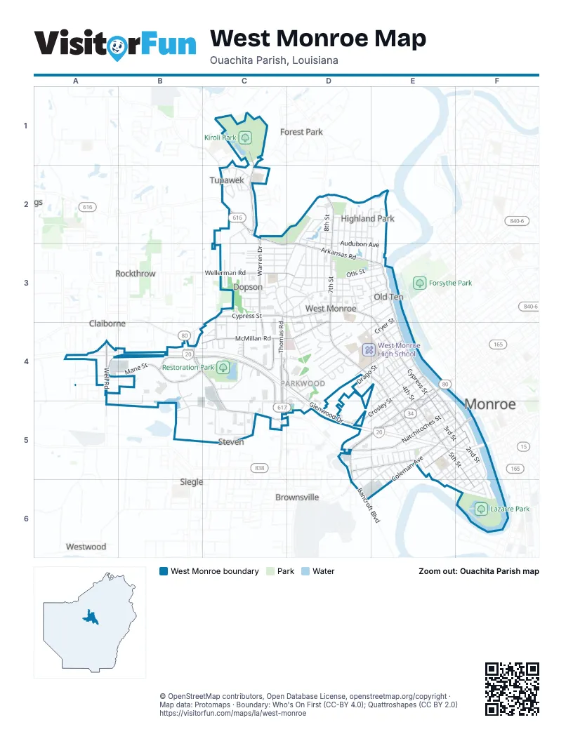
Street index of West Monroe
Each street on the sheet and the grid squares it crosses.
- Cypress StreetC3, D3, E3, B4, E4, E5
- North 7th StreetD2, D3, D4, E4, E5
- Stella StreetE4, D5, E5
- Well RoadA4, A5
- Mill StreetE4, E5
- Jonesboro RoadD5, D6
- Bridge StreetE4, E5
- Louisville AvenueE4
- Whites Ferry RoadD2
- Arkansas RoadC2, D2, C3, D3, E3
- Thomas RoadC3, C4, C5
- Warren DriveC2, C3
- Trenton StreetE3, E4, E5, F5
- Constitution DriveB4, C4, C5
- Downing Pines RoadB4, C4, C5
- McMillan RoadD3, B4, C4, D4
- Coleman AvenueE5, F5, E6
- Natchitoches StreetD5, E5
- Mane StreetA4, B4
- Glenwood DriveC4, D4, D5
- Kiroli RoadC1, C2
- North 4th StreetE4, E5
- Blanchard StreetC4
- Wellerman RoadC3, D3
- Crosley StreetE4, D5, E5
- Montgomery AvenueD5, E5
- South 5th StreetE5, F5, F6
- Travis StreetD4, E4
- Linderman AvenueE5, F5
- Good Hope RoadC2
- South 1st StreetF5
- Service RoadA4
- Bell LaneC3, C4
- Hilton StreetC4
- Short Constitution DriveB4, C4
- Old Darbonne RoadC1, C2
- Desiard StreetF5
- Old Natchitoches RoadD5
- South Riverfront StreetF5, F6
- North 8th StreetD2, D3, E4, E5
- North 3rd StreetE4, E5
- Otis StreetD3, E3
- North 5th StreetD4, E4, E5
- North 9th StreetD2, D3, E5
- North 6th StreetD4, E4, E5
- Cemetery RoadC2, D2, C3
- Splane DriveC3, D3
- Audubon AvenueD2, D3, E3
- Drago StreetD4, E4
- Parkwood DriveD3, D4
- Wood StreetE5, F5
- North 10th StreetD2, D3, E5
- Haynes StreetE4, E5
- Arlington PlaceD2, E2, D3
- Ridge AvenueC3, D3
- Hicks StreetC2, C3
- Austin AvenueE5, F5
- Exchange StreetB5, C5
- Lazarre AvenueE5, F5, E6
- Slack StreetD4, E4
- Maridale DriveD2, D3
- Riggs StreetD3, D4, E4
- Drew AvenueE4
- South 2nd StreetE5, F5
- Pavillion RoadB4, B5
- Wheelis StreetE5, D6
- Commercial ParkwayC4
- Gulpha DriveD2, D3
- South 3rd StreetE5, F5
- Frost Commercial DriveB4, A5, B5
- Claiborne StreetE3, D4, E4
- North 11th StreetD2, D3, E5
- Cryer StreetE3, D4, E4
- Clayton StreetE4, E5
- Oakland StreetE4
- Vernon StreetE4, E5
- Olympic DriveD2, E2
- Mitchell LaneF5, E6
- Swiss StreetD3
- Circle DriveD3, D4
- South 8th StreetE5, E6
- Grantham AvenueC5
- Riverbend DriveE6, F6
- Ferndale AvenueD2, D3
- South 4th StreetE5, F5
- Basic DriveC4, D4, C5, D5
- Fairfield StreetD2, D3
- Oaklawn DriveD3, E3
- Division StreetD2
- Ludwig AvenueE5, F5
- Elizabeth StreetC3, D3
- Tupawek DriveC2
- Cotton StreetE4, E5
- Hemlock CircleD4
- Jackson StreetD3, E3
- Herman StreetD3
- Chickasaw DriveD2, D3
- Parkwood BoulevardA4
- Jersey StreetC3, D3
- Woodrow StreetD5, E5
- Shaw StreetD3
- Cedar StreetC3, D3
- Benson StreetE4
- Tulane AvenueC3, D3
- Church StreetD3
- Parkwest DriveD4
- Phillips StreetE5
- River Oaks DriveD2, E2
- McGuire StreetD3
- Avant StreetC2
- Flanagan StreetD3
- Morris AvenueE4
- North 12th StreetD2, D3
- Woodland StreetC3, D3
- Filhiol AvenueE5, F5
- Northwood CircleC2
- Trenton BendD3, E3
- Meadowbrook DriveD2
- Register StreetE4
- Willis StreetC3, D3
- Westland PlaceD4
- South 6th StreetE5, F5, F6
- Lee StreetD3
- Marie StreetD4
- Browning StreetF5, F6
- Medorah DriveD4
- Arlene StreetC3
- Height StreetC3, D3
- Reagan StreetD5, E5, D6
- Madison StreetD3, E3
- Wassan StreetC5
- Shadow Creek DriveC4
- Sunset DriveC4
- Mallard AvenueE2, E3
- Lomaland DriveE2, E3
- Edgemont DriveD2, E2
- Anderson StreetF5, F6
- Regency PlaceD4
- Carter DriveC3
- Bancroft BoulevardD6
- McClendon AvenueE5, F5
- Su Quak Natch Ah StreetC3, C4
- Hines LaneC3, C4
- Fairview StreetC3, C4
- Eby StreetE5, E6
- Enterprise StreetC5
- Lincoln StreetD3
- South 9th StreetE5, E6
- Crawford StreetD5, E5
- Industrial StreetC5
- North 2nd StreetE4, E5
- Park AvenueE5, F5
- Copley StreetE3
- Choctaw DriveC2
- Janna DriveC3
- Vernon LaneA4
- Parnell StreetE4
- Powell StreetD3
- Wilson StreetE5
- Tanner LaneD2
- Professional DriveD4
- Pelican DriveD3, E3
- Gilbert DriveC3
- Highand Park DriveD3
- Elias AvenueC3
- Mauldin DriveC3
- White Columns DriveC3
- Tupelo DriveD4
- Stewart AvenueF5
- Hamilton StreetF6
- McBeth AvenueD4
- Cason StreetF5, F6
- Hinkle StreetE4
- Oak DriveD4
- Conella StreetD3, E3
- Lakeshore DriveD2
- Ponderosa TrailC2
- Plum StreetE5
- Laurel StreetE3
- Peach StreetE5
- Thompson StreetF5
- Nye StreetD3
- Pine Terrace DriveD4
- Ada StreetC3
- South 7th StreetE5, F6
- River Oaks ExtendedE2
- Pine CircleC4
- Florence StreetC3
- Island DriveE2
- Julia StreetD3, D4
- Frantom LaneC3
- Clay StreetC3
- Sunshine AvenueC3, D3
- Teakwood DriveD4
- Hodge StreetE4
- McBride StreetC2
- Orleans PlaceC3
- Royal StreetD4, E4
- Sunrise DriveB4, C4
- Olde Town CIrcleC3
- Fairlane DriveC2, C3
- Nichols DriveC2
- Short Jackson StreetD4
- Commerce StreetE5, F5
- Short Coleman StreetE5
- Dopson PlaceC3
- Liberty DriveD3, E3
- Conrad StreetD3
- Cortez StreetD3, D4
- Larche DriveD4
- McClendon Church RoadC5
- Kelly StreetD4
- Tuscany CircleC3
- Jason DriveD4
- Ned StreetE5
- McAlpine DriveD4
- North Stewart StreetD3
- Ozone StreetD3
- Olde Oaks DriveA4
- Summit DriveD2
- Crescent DriveE4
- Grover AlleyE5, F5
- Briarwood DriveC2
- Gross StreetC3
- Clover DriveE3
- Richards LaneD3
- South 10th StreetE5
- Barfoot RoadA5
- Short StreetE5
- Pear StreetE5
- South Riverbend DriveF6
- Orange StreetE5
- Expo CircleB4
- Commercial CircleC4
- Independence DriveD5
- Melanie LaneD3
- Wilhite StreetC4
- Zephyr StreetD3
- Grape StreetE5
- Rex StreetE5, E6
- Alpha StreetE5
- Heard StreetE5
- Moreland DriveD3, E3
- Ransom StreetE5
- Reamus StreetE5, E6
- Bay StreetD4
- Cherry StreetE5
- Miller StreetE5
- South 11th StreetE5
- Knowles LaneD3
- Landrum StreetC3
- Ridgeway DriveC2
- Contempo AvenueD4
- Long StreetE5
- Class StreetD3
- Apple StreetE5
- Hill StreetE5
- Brent RoadC5
- Vine StreetD3, E3
- Bradley DriveC2
- Redwood DriveC2
- Casa Grande StreetC2
- Rue LaplaceC2
- Sharon DriveC2
- Somerset DriveC4
- Patton DriveC2
- Hood StreetE5
- Racove DriveC4
- Young StreetE4
- Sholars StreetF6
- Bailee DriveC4
- Chestnut TerraceC2
- Boyd StreetD5
- Pine StreetE5
- Campbell LaneD5
- May StreetD6
- Greenwood StreetD2
- Eagle Ridge LaneC1
- School StreetE5
- Short Lee StreetD3
- Hoover StreetD5
- Italiana PlaceC3
- North Riverfront StreetF5
- Thornton RoadD5
- Waterplant RoadC4
- Swan CircleC3
- Parent StreetD3
- Prune StreetE5
- North Church StreetD4
- Lindberg StreetD5
- Towne CircleC4
- Esplanade PlaceC4
- West Highland DriveC2
- Comanche CircleC2
- Shawnee CircleC2
- Stix StreetC3
- Joy StreetC3
- Poke StreetD4
- Pinecone DriveD3
- Firecracker DriveD3
Places on the map
- Ace Mini Storage
- Americas Best Value Inn
- Antique Alley
- Anytime Fitness
- AutoZone
- Azteca Super Mercado
- B&E Wholesale
- Baker Distributing Company
- Bayou Butts and Booze
- Best Western
- Boley Elementary School
- Bon Temps Classical Pilates
- Brookshire's
- Cadence Bank
- Cash America Pawn
- Centric Federal Credit Union
- Chase
- Chevron
- Chick-fil-A
- Chili's
- Christ Church
- Cinemark Tinseltown 17
- Glenwood Medical Mall
- Hasley Cemetery
- Highland Wetland Walking Trails Park
- Ike Hamilton Expo Center
- Kiroli Elementary School
- Kiroli Park
- Kiroli Reservoir
- Lazarre Park
- Ouachita River
- Pilot Travel Center
- Rebel Stadium
- Restoration Park
- Riverbend Elementary School
- Ronald Brady Memorial Park
- The UPS Store
- Tupawek Bayou
- Walmart Supercenter
- West Monroe High School
Next to West Monroe
- Brownsville
- Claiborne
- Claiborne Fairview
- County Side
- Forest Park
- Kiroli Woods
- Monroe map
- Pine Terrace
- Rockthrow
- Siegle
- West Heights
- Westwood
© OpenStreetMap contributors, Open Database License, openstreetmap.org/copyright · Map data: Protomaps · Boundary: Who's On First (CC-BY 4.0); Quattroshapes (CC BY 2.0)















