

Louisiana map
Ouachita Parish map
About 157,874 people live here (Census Bureau, 2024 estimate). The sheet's index lists 300 streets; Jonesboro Road, Whites Ferry Road and New Natchitoches Road cross the most grid squares. Things to do inside the boundary: Biedenharn Museum & Gardens and Chennault Aviation and Military Museum.
Open the map (PDF, US Letter)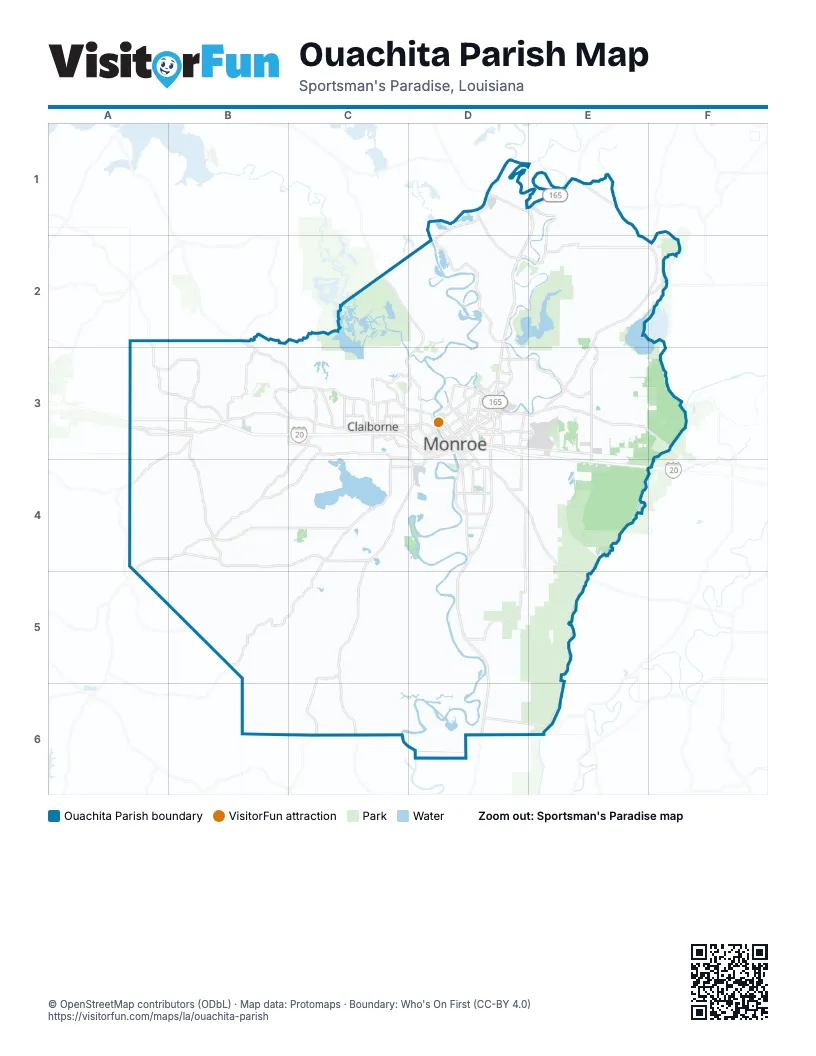
Maps inside Ouachita Parish
2 maps inside, from the street map of Ouachita Parish down.
Street index of Ouachita Parish
Each street on the sheet and the grid squares it crosses.
- Jonesboro RoadD3, B4, C4, D4
- United States Highway 165E1, D2, E2
- Cheniere-Drew RoadC3, B4, C4
- Cypress StreetB3, C3, D3
- Sterlington RoadD2, D3
- Whites Ferry RoadC2, D2, C3, D3
- Jackson StreetD3, D4
- Desiard StreetD3, E3
- Martin Luther King Jr DriveD3, D4
- Highway 34A4, B4, A5
- State Highway 15B2, B3, C3
- North 7th StreetD3
- Louisville AvenueD3
- North 5th StreetD3
- North 6th StreetD3
- Stella StreetD3
- Well RoadC3
- Ouachita AvenueD3
- Lea Joyner Memorial ExpresswayD3
- Calypso StreetD3
- Mill StreetD3
- Layton AvenueD3
- Sterlington BridgeD1
- Bridge StreetD3
- New Monroe RoadE1
- Highway 143C2
- Highway 557C4, C5, C6
- Highway 139E2, F2, E3
- Winnsboro RoadD4, E4, E5
- Prairie RoadD4, D5
- New Natchitoches RoadC3, D3, B4, C4
- Lapine RoadC4, B5, C5
- Swartz Fairbanks RoadE2
- Arkansas RoadC3, D3
- Highway 134D2, E2, F2
- Millhaven RoadD3, E3
- Washington StreetC3, D3, C4, D4
- Cheniere Dam RoadC4
- Forsythe AvenueD3
- Russell Sage RoadE3, E4
- Highway 151A2, A3
- Camp RoadB3, C3
- Garrett RoadD3, D4
- Highway 594E2, E3
- Highway 554E1
- Thomas RoadD3, D4
- South 3rd StreetD3, D4
- South 2nd StreetD3, D4
- Kansas LaneD3
- North 18th StreetD3
- Swartz School RoadE3
- Lincoln RoadE3
- South 10th StreetD3, D4
- Smith StreetC4, D4
- Texas AvenueD3
- Forsythe BypassD3
- Warren DriveC3
- Highway 546C3
- South 18th StreetD3
- Louise Anne AvenueD3
- Airport ExpresswayD3
- Catalpa StreetD3
- Hall StreetD3
- Old Bastrop RoadE3
- I-20 Frontage RoadD3
- East Cutover StreetD3
- State Route 15E5
- Highway 548B5
- State Route 557C6
- Coulee Swamp RoadF2
- Horseshoe Lake RoadD1, D2
- Caples RoadB4, C4
- Old Sterlington RoadD1, D2, D3
- Brownlee RoadB3
- Service RoadC3, D3, D4
- South Grand StreetD3, D4
- Finks Hideaway RoadD3, E3
- Pine Bluff RoadC5, C6
- Bosco LaneD6, E6
- Highway 136E1, E2
- Slocum RoadB3, C3
- Keystone RoadD1, D2
- Rowland RoadE3
- Oliver RoadD3, E5
- Breard StreetD3
- Park AvenueD3
- Burg Jones LaneD4
- Owens RoadA3, B3, C5, C6
- North 4th StreetD3
- Loop RoadD3
- Claiborne RoadB3
- Ole Hwy 15C3
- South 5th StreetD3, D4
- Avant RoadC3
- Trenton StreetD3
- Plum StreetD3, D4
- Standifer AvenueD4
- Good Hope RoadC3
- Pecanland Mall DriveD3
- South 8th StreetD3, D4
- New Chapel Hill RoadC3
- Hadley StreetD4
- Powell AvenueD3
- Harrell RoadC3
- Constitution DriveC3, D3
- Wilson StreetC3, D3, D4
- Downing Pines RoadC3, D3
- Glenwood DriveD3
- Wellerman RoadC3, D3
- Richwood Road 2D4
- Riverside DriveD3
- Wall Williams RoadC3, D3
- Wallace Dean RoadC3
- Pine StreetD3
- McMillan RoadC3, D3
- North 19th StreetD3
- Richwood Road 1D4
- Coleman AvenueD3, D4
- Glenmar AvenueD3
- South 1st StreetD3, D4
- Forty Oaks Farm RoadC3
- Cadeville Cutoff RoadB4
- Natchitoches StreetD3
- Tower DriveD3
- University AvenueD3
- Ticheli RoadD4
- Mane StreetC3
- Wallace RoadC3
- Lamy LaneD3
- Renwick StreetD3
- Hilton StreetC3, D3
- Armand StreetD3
- Old Darbonne RoadC3, D3
- Calhoun School RoadB3
- Central AvenueD3, E3
- Louberta StreetD3
- Kiroli RoadC3
- Operations RoadD3, E3
- Norris LaneC3
- Green RoadC3
- Blanchard StreetC3, D3
- Harvester DriveD3
- Construction AvenueD3
- South College AvenueD3
- Old Natchitoches RoadD3
- Crosley StreetD3
- Northeast DriveD3
- Montgomery AvenueD3
- Dean Chapel RoadC3
- Bayou Oaks DriveE3
- West Elmwood DriveD3
- Laird StreetC3
- Travis StreetD3
- Marie PlaceD3
- Ferrand StreetD3
- Walnut StreetD3
- Linderman AvenueD3
- Cheeks RoadC3
- Elm StreetD3
- Highway 151 NorthB3
- Old Highway 2D1
- South 24th StreetD3
- Swayze StreetD3
- Webster StreetD3
- Dunlop StreetD3
- Cheniere Station RoadC3
- Cheniere RoadC3
- Central Avenue NorthE3
- Bell LaneC3
- Southeast RoadE3
- Magnolia StreetD3
- Butler AvenueC3
- Short Constitution DriveC3
- North Grand StreetD3
- State Route 553D1
- De Siard StreetD3
- Red Cut RoadC5
- Philpot RoadC4, C5, D5
- River RoadD5, D6
- Red Cut Loop RoadC5
- Stubbs Vinson RoadE2, E3
- Frontage RoadD3, E3, E4
- Old Wall Lake RoadD2
- Winnfield RoadB4
- Britton RoadB3, B4
- Stubbs Ritchie RoadE3
- Charles Griggs RoadC5
- Buckhorn Bend Loop RoadD4
- Okaloosa RoadB4, B5
- Toney Bayou RoadD4
- Cypress School RoadC5, B6, C6
- Jim Reeves RoadC6, D6
- Jack Crowell RoadB5
- Guyton Swamp RoadA4
- Cooney Bonnett RoadB4, B5
- Frost Tower RoadC5
- Crowell RoadB5
- Golson RoadB3, B4
- Blankston RoadD6
- Harmon Johnson RoadD5
- Luebenia RoadA4, B4
- Joe Holton RoadA4, A5, B5
- Miller RoadE4, D5, E5
- Downs RoadC5
- Lee Anding RoadC5, D5, D6
- Lee AvenueD4
- Beulah Church RoadA3, A4
- William Harris RoadB3, B4, C4
- Deborah DriveD3
- Leckie RoadB4
- Gourd Bayou RoadE4
- Puckett Lake RoadC3, C4
- Strozier RoadC3
- Comanche TrailC3
- Hooter RoadD6
- North 8th StreetD3
- Bon Aire DriveD3
- Moon Lake RoadD2
- Griggs RoadA3, B3
- Durwood Crowell RoadB5
- Ben Wink RoadB5, B6
- Joe White RoadD2, D3, E3
- Watson School RoadC5, D5
- Rogers RoadD3, C4
- Guyton Loop RoadA4, B4
- Tidwell RoadC4, D6
- North 3rd StreetD3
- Barnes RoadC2, E2, C3
- Parker RoadD4, E4
- Richardson RoadB3
- Forest Homes RoadC6, D6
- Bogaloosa RoadB5
- Lovelady RoadB4, B5, C5
- Logtown School RoadD5
- Tom Rawls RoadC5, C6
- Barney Frith RoadB5, C5
- Wood StreetD3
- Cummings RoadB5
- George Simmons RoadC5, C6
- Jack Tolbird RoadB5
- Garland Gin RoadB2, B3
- Whitewood RoadD2, D3
- Buckhorn Bend RoadD4
- Carey Nelson RoadB4
- Grammont StreetD3
- Mock RoadC5, D5, D6
- Elkins RoadC4
- Jones RoadD5
- Mount Olive Church RoadB6
- Acadian LaneD2, E2
- Ruby RoadE4
- Nutland RoadD3, D4
- Moore RoadD4, E4
- Morgan Hare RoadE2, F2
- Plum Hill RoadA4
- Hodge Watson RoadB3
- Baron RoadE1
- Angus RoadD5
- New Wall Lake RoadC2, D2
- South 6th StreetD3, D4
- Belle Cote RoadC6, D6
- Frenchmans Bend RoadD2, E2
- East Puckett Lake RoadC4
- Howard Brown RoadB4
- McHenry Gin RoadD5
- Ike Kelly RoadC4, C5
- East Frenchmans Bend RoadD2, E2
- Stubbs McCormick RoadE3
- Hyper RoadE4
- Brown RoadB3, D4
- Cypress Church RoadC5, C6
- Pargoud BoulevardD3
- Cuba BoulevardD3
- Hull George RoadB5
- Abe Benton RoadA3
- Ervin Cotton RoadB4
- Mansfield RoadD6
- Sibley RoadA3
- Dan Lenard RoadC5, C6
- Fannin RoadC4, C5
- McGowen RoadE3
- Johnson RoadC3
- North 10th StreetD3
- South Riverfront StreetD3, D4
- Sivils RoadF1, F2
- Lakeshore DriveD3, E3
- North 9th StreetD3
- Demoss RoadB5, E5
- Sam Head RoadB4, B5
- Line RoadC5, D6
- Sycamore LaneD4, D5
- Henderson RoadC3, B4
- Edwards RoadC4
- Ouachita City RoadD1
- Jim Arrant RoadC4
- Henry Martin RoadC6
- Spencer AvenueD3
- Orange StreetD3, D4
- New Mineral Spring RoadA4, B4
- Olive StreetD3
Things to do on the Ouachita Parish map
Places on the map
- Bayou D'Arbonne
- Bayou Desiard Country Club
- Bayou deSiard waterbank
- Bayou deSiard Waterbank
- Bayou Desiard waterbank
- Bayou Lafourche
- Black Bayou Lake
- Black Bayou Lake National Wildlife Refuge
- Brownsville-Bawcomville
- Chenault Park
- Cheniere Lake
- Chennault Park Golf Course
- Claiborne
- Devil's Hole
- Forsythe Park
- Forsythe Point Recreation Area
- Frenchmans Bend
- Hamilton Lake
- Horseshoe Lake
- Kiroli Park
- Lake Lafitta
- Lapine Brake
- Magnolia Landfill
- Monroe
- Moon Lake
- Ole South Pecan Farm
- Ouachita River
- Pace Lake
- Panhandle Bayou
- Prairion Brake
- Richwood
- Russell Sage Wildlife Management Area
- Sterlingotn Sports Complex
- Sterlington
- Swartz
- The Basin
- Wall Lake
- Watson Brake
- West Monroe
- Whites Lake
© OpenStreetMap contributors, Open Database License, openstreetmap.org/copyright · Map data: Protomaps · Boundary: Who's On First (CC-BY 4.0); Quattroshapes (CC BY 2.0)















