

Louisiana map
St. John the Baptist Parish map
About 39,694 people live here (Census Bureau, 2024 estimate). The sheet's index lists 300 streets; West Airline Highway, Old US Highway 51 and Saint Andrews Boulevard cross the most grid squares. Things to do inside the boundary: Cajun Pride Swamp Tours, Godchaux–Reserve Plantation and Whitney Plantation.
Open the map (PDF, US Letter)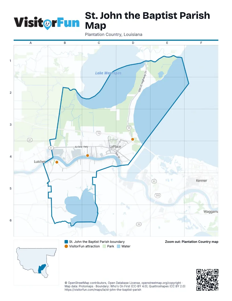
Street index of St. John the Baptist Parish
Each street on the sheet and the grid squares it crosses.
- West Airline HighwayB4, C4, D4
- East Airline HighwayD4
- Belle Terre BoulevardC3, C4
- Gramercy BridgeB4
- Airline HighwayD4
- Woodland DriveD3, D4
- Central AvenueB4, C4
- West 5th StreetC4
- Main StreetC4, D4
- River RoadC4, D4
- Highway 54B4
- Old US Highway 51D1, D2, D3
- Saint Andrews BoulevardC3, D3, D4
- East 5th StreetC4, D4
- Cambridge DriveD3, C4, D4
- West 2nd StreetB4, C4
- East 22nd StreetC4
- West 10th StreetC4
- Cardinal StreetC4, D4
- Elm StreetC4
- Fir StreetC4
- Highway 639B4
- Hemlock StreetC4
- Parish Road 51D1
- Fairway DriveC4, D4
- Greenwood DriveC4, D4
- Godchaux Canal RoadC3, C4
- Dupont Construction RoadC4
- Railroad AvenueC4
- Garyville Northern StreetB4
- Rosenwald StreetC4
- West 1st StreetB4, C4
- West 19th StreetC4
- Yorktowne DriveD3, C4, D4
- English Colony DriveD3, D4
- Magnolia AvenueC3, C4
- Gold Mine Plantation RoadC4
- East 6th StreetC4
- East 14th StreetC4
- Annex DriveC4
- Camelia AvenueC3, C4
- Country Club DriveC3, C4
- East 13th StreetC4
- Glendale Plantation RoadC4
- Devon RoadD4
- Somerset RoadD4
- West 3rd StreetB4, C4
- Williamsburg DriveD3, D4
- Castle DriveB4
- South Church StreetB4
- Cureaux LaneB4, D4
- Homeswood PlaceC4
- Northwest 3rd StreetC4
- West 8th StreetB4, C4
- Historic Main StreetB4
- Daffodil StreetB4
- West 13th StreetB4, C4
- Peavine RoadD3
- Oak Point DriveC3, D3
- South Little Hope StreetB4
- Indigo ParkwayD3, D4
- Tiffany DriveC4
- South Emile StreetB4
- Carrollwood DriveC4
- Holly DriveC4
- East 12th StreetC4
- Northwest 2nd StreetC4
- North Sugar Ridge RoadC4
- Woodville RoadB4
- Historic West StreetB4
- Whitlow CourtC4
- Tuscany DriveD4
- Airport RoadB4, C4
- East 11th StreetC4
- East 7th StreetC4
- East 3rd StreetC4
- Belle Pointe BoulevardC4
- Madewood DriveC4
- East 26th StreetC4
- Virginian Colony AvenueD4
- Capt G Bourgeois StreetC4
- East 27th StreetC4
- Madewood RoadC4
- East 24th StreetC4
- West 4th StreetB4, C4
- Ellerslie AvenueC4
- Historic East StreetB4
- South Fig StreetB4
- Bert StreetC4
- East 16th StreetC4
- McReine RoadD4
- Lakewood DriveC4
- Derek LaneD4
- Carmel Valley DriveC3, C4
- Terrio DriveC4
- Gardenia StreetC3, C4
- East 4th StreetC4
- Maple LoopC4
- Chad B Baker StreetC4
- West 7th StreetB4, C4
- Karlstein RoadB4
- Muirfield DriveC3
- South Sugar Ridge RoadC4
- Za RoadC4
- River PointeC4
- Ridgefield DriveC4
- Van Arpel DriveC4
- Cartier DriveC4
- East 15th StreetC4
- Melius DriveC4
- Big Lou AvenueC4
- Riverlands DriveD3, D4
- Jackie StreetC4
- Des Allemands BoulevardB6
- La Place Trailer Pike CourtD4
- Windsor DriveD4
- Bardwell DriveC4
- Columbia Factory RoadC4
- West 16th StreetA4, B4, D4
- Dufresne DriveA4
- East 9th StreetC4
- South Pass DriveD3, D4
- Walnut StreetD4
- Shearwater DriveD4
- Foxwood LaneC3, C4
- Marquez StreetB4
- Lafitte StreetC4, D4
- Amp CircleB4
- Oakmont DriveC3, C4
- West 9th StreetB4, C4
- Sherman Walker StreetB4
- Anthony F Monica StreetB4
- East 2nd StreetC4
- Chestnut StreetB4
- Grove ParkC4
- Evergreen Plantation RoadB4
- Hotard DriveC4
- Sunny Side DriveC4
- Orange LoopC4
- Moss DriveD4
- Rue de SantéC4
- Power BoulevardC4
- West 15th StreetA4, B4, C4
- East 17th StreetC4
- Marigold StreetB4
- East 10th StreetC4
- Regala Park RoadC4
- Golfview DriveC4, D4
- Jaubert LaneD4
- Oak Tree DriveC3, C4
- Ridgewood DriveD4
- Joe Parquet CircleC4
- L & L CourtB4
- Jean Marie StreetC4
- Cedar DriveC4
- East Lakeview DriveC4
- East 12th Street ExtensionC4
- East 23rd StreetC4
- Wildcat DriveC4
- North Little Hope StreetB4
- Melrose DriveC4
- Old Highway 640C4
- East 1st StreetB4, C4
- East Frisco DriveD4
- Champion DriveC3, C4
- Apricot StreetC4
- Aline StreetD4
- Palmetto DriveD4
- Lee DriveC4
- Turnberry DriveC3
- Goldmine CourtC4
- Timbermill LoopB4
- Delta RoadC4
- Laurel Valley DriveC3
- Tammy DriveD4
- Oak Park BoulevardB4
- West 23rd StreetB4
- Bell Grove DriveD4
- Colonial DriveC3, C4
- Portrush DriveC3, C4
- West Lakeview DriveC4
- Miano StreetB4
- Augusta DriveC3, C4
- West 6th StreetB4, C4, D4
- Goshen LaneC4
- West 24th StreetB4
- Ivy CourtC4
- Parker LaneC4
- Jefferson StreetC4
- Warwick StreetD4
- Bedford StreetD4
- Surrey DriveD4
- Toni DriveC4
- West 14th StreetB4, C4
- Buckingham StreetD4
- Sugar Cane RoadB4
- North Church StreetB4
- Bayonne DriveC4
- Mahogany StreetC4
- Hebert DriveC4
- Welham LoopC4
- Bellevue DriveC4
- Revere DriveD3
- Cole's LandingC4
- Museum StreetB4
- Longwood CourtC4
- Concord DriveC4
- Cynthia CircleC4
- East 21st StreetC4
- Fairview DriveC4
- West Frisco DriveC4
- Parish RoadC4
- Pebble Beach DriveC3, C4
- Rue Saint JohnB6
- Nottingham RoadD4
- Ox Bow DriveD3, D4
- RTC DriveC4
- Marjorie CourtD4
- Sawgrass DriveD4
- Beach Grove DriveC4
- Daisy StreetB4
- West 12th StreetB4, C4
- Concordia DriveD3, D4
- Rue Saint JamesB6
- Paula DriveD4
- Riverview CourtD4
- Esplanade StreetC4, D4
- Ingleside RoadD4
- Esperance StreetB4
- Robichaux DriveD4
- Summerlin DriveD4
- Ory DriveC4
- Houma DriveC4
- Bamboo RoadD4
- Farm RoadD4
- Jordan CourtD4
- Roccaforte AvenueB4
- Bourgeois Town StreetB4
- Creole StreetC4
- Oak Ridge DriveD4
- Glendale DriveC4
- Cemetery RoadC4
- Oswald AvenueD4
- Birch StreetC4
- Jackson AvenueC4
- Rue Saint CharlesB6
- Azalea DriveD4
- River Oaks DriveC3, D3
- Shadowbrook LaneD4
- Pinehurst DriveC3, C4
- Rue Saint MartinB6
- Kathy DriveD4
- Percy CourtB4
- Sycamore LoopC4, D4
- Coosie DriveC4
- Kimball DriveD4
- Lafayette DriveD4
- Peacock RoadD3
- La Salle DriveD4
- Lemoyne DriveD4
- Plymouth DriveD4
- East 31st StreetC4
- Emilen CourtC4
- Rodrigue CourtC4, D4
- Natchez LaneC4
- Lexington DriveD4
- East 30th StreetC4
- Pine Valley DriveC3
- Simon StreetD4
- Gary RdD3
- Bonnie StreetD4
- Highland DriveC4
- West 17th StreetC4
- Hollywood Park DriveD4
- East 28th StreetC4
- Ash StreetC4
- Colonial CircleD4
- Hickory StreetC4
- Emma DriveC4
- Sandpiper DriveD4
- Emmett CourtD4
- Mockingbird LaneD4
- Ormond BoulevardC4
- West 18th StreetC4
- Cane DriveD4
- Balsam StreetC4
- Oak Arbor DriveC3, D3
- Poppy LaneD4
- Anderson CourtD4
- Parlange LoopC4
- Marmillian LoopC4
- Grant DriveC4
- Freddies EstateC4
- Buster StreetB4
- Gail DriveD4
- Hancock DriveD4
- Oscar DriveC4
- Kenilworth DriveC4
- Cornland DriveC4
- Elvina StreetD4
Things to do on the St. John the Baptist Parish map
Places on the map
- 1811 Kid Ory Historic House
- Advance Auto Parts
- ALDI
- Ascension of Our Lord Catholic Church
- Belle Terre Country Club
- Best Western
- Bishop Cemetery
- Bonnet Carré Kennels
- Cajun Pride Swamp Tours
- Chase
- East Saint John High School
- Edgard
- Evergreen Plantation
- Fifth Ward Elementary School
- First Canal
- Garyville
- Garyville Post Office
- Juan Anthony Joseph
- Lac Des Allemands
- LaPlace
- Larayo Youth Park
- Limited Access Area
- Manchac Wildlife Management Area
- Maurepas Swamp Wildlife Management Area
- Mount Airy Post Office
- Old Garyville Timbermill Pond
- Port of South Louisiana Exec Rgnl Airport
- Reserve
- Reserve Post Office
- Riverland Country Club
- Saint John Parish Police Jury
- Saint John the Baptist Parish
- Specialty Rehabilitation Hospital
- TA Express
- The Prairie
- Thomas F. Daley Memorial Park
- Wallace
- West Saint John High School
- Whitney Plantation
Next to St. John the Baptist Parish
- Kenner map
- Lutcher
- Waggaman
© OpenStreetMap contributors, Open Database License, openstreetmap.org/copyright · Map data: Protomaps · Boundary: Who's On First (CC-BY 4.0); Quattroshapes (CC BY 2.0)















