

Louisiana map
Zachary map
About 20,370 people live here (Census Bureau, 2024 estimate). The sheet's index lists 300 streets; Pride Port Hudson, Old Scenic Highway and Main Street cross the most grid squares. Also on it: Fenwood Hills Golf Course, Zachary Youth Park and Brians Ultralight Airport.
Open the map (PDF, US Letter)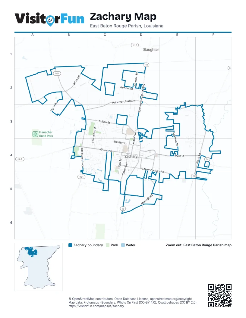
Street index of Zachary
Each street on the sheet and the grid squares it crosses.
- Church StreetB4, C4, D4
- Main StreetC4, D4, E4, F4
- Zachary-Slaughter HighwayD2, D3, D4
- Scotlandville-Zachary HighwayD4, D5, C6
- Zachary Deerford RoadD4, E4, F4
- Mount Pleasant Zachary RoadB4
- High StreetD4
- Old Scenic HighwayB1, B2, B3, B4, B5
- Pride Port HudsonC2, D2, F2, B3, C3, E3, F3
- Plank RoadF3, F4, E5
- Lower Zachary RoadD4, E4, E5
- McHugh RoadD4, D5
- Rollins StreetB3, C3
- Montegudo BoulevardD4
- Rollins RoadC3, D3, D4
- East Central AvenueD3, D4
- Port Hudson Plains RoadA2, B2
- Brian RoadB2
- Baker AvenueD4, C5, D5
- 39th StreetC4, C5
- Rollins PlaceD3
- Avenue AD4
- Old Baker Zachary RoadC5
- Old Weis RoadD4
- Carpenter RoadD4
- New Weis RoadD4
- Chestnut StreetC4, D4
- Sunset BoulevardD3
- Spur LaneC5, D5
- Machost RoadE3, E4
- W. J. Wicker RoadE3, F3
- Fennwood DriveC3, C4
- Vernon RoadC2, D2
- Munson DriveD2
- Little Farms DriveE4, E5
- Ligon RoadB2, B3
- Knight DriveC3, C4
- Shaffett LaneC4, D4
- Old Slaughter RoadD4
- Redwood Lake BoulevardE4, F4
- Newell StreetC3, C4
- Lee StreetD4
- Copper Mill BoulevardB4, C4
- Rush AvenueD2
- Lake Pointe AvenueB4, C4
- Yardley DriveD2
- Robert StreetC4, D4
- West Central AvenueD4
- Noble StreetC4, D4
- Cherry StreetC4, D4
- South Turnberry AvenueC4, C5
- Nelson StreetC4, D4
- Pope RoadC3, C4, D4
- Millwood Creek CourtE3, F3
- Royal Troon CourtB5, C5
- Sandy Creek LaneC3
- Raven Way DriveB4, C4
- English Turn DriveC3
- Pointe SouthC4
- Cypress StreetC4
- Old Barnwood AvenueB4, C4
- Holly StreetC3
- Camelia StreetC3
- East Vernon RoadD2
- Woodbend DriveC3
- Highland Oaks AvenueE3, F4
- North Turnberry AvenueC4
- 40th StreetC4, D4
- Hemlock StreetC4, D4
- Deanne Marie DriveC3, C4
- Redbud StreetC3
- Mills Pointe DriveC3
- Eagle DriveB3, C3
- Windwood DriveC3
- Cypress Park DriveC5
- Jersey DriveE4, E5
- Sophie Anne DriveC3, C4
- Pin Oak LaneC2, C3
- Woodside DriveC3
- Florida StreetD4
- Saint Louis StreetD4
- Marshall Bond DriveC3
- Saint Andrews AvenueC4
- OakleyC2, C3
- Maple StreetC3
- Truman StreetD4, D5
- WoodlandD4, E4
- Moss Trail DriveB4, C4
- Reserve Oak AvenueE3, E4
- Cedar StreetC4, C5
- Angus AvenueE4, F4
- Lakeland DriveC3
- Shellmire LaneB2
- Waterford DriveC3, C4
- Queens Carriage StreetC4
- General Gardner LaneB2
- OrmandC2, C3
- Saul AvenueB3
- Myrtle Hill AvenueC4
- Summerline DriveC3
- Mae StreetD4
- Marianne DriveC4
- Bod Odom DriveD4
- Mc Hugh DriveD4
- Rita StreetC3
- Honeysuckle DriveC4
- Flonacher RoadB3
- Hillcrest DriveD3
- Creek Hollow AvenueC4
- Zelmere StreetC4
- Ash StreetC3
- Rue Lierre StreetC3
- South Vernon DriveC2
- Fairway DriveB3, C3
- Frank Brian RoadB2
- Dottie Lee DriveC2
- East Eagle StreetC3
- Young StreetD4
- 38th StreetC4
- 42nd StreetD4
- West Vernon RoadC2
- RonnieD3
- Leviticus DriveB3, B4
- Ramey DriveD4, D5
- Hackberry Ridge AvenueE4
- West George StreetC3, C4
- Avenue KD4
- Lakewood DriveC4
- Live Oak TraceC4
- Lois DriveD4
- Mallard Crossing DriveE4
- Carriage Ride LaneB2
- Fleur De Lis StreetC3
- Red Clover AvenueC4
- Cherry Laurel AvenueE4
- Black Birch AvenueE4
- Job AvenueB3
- Meadow Grove AvenueB4, B5
- Stonehedge DriveC4, C5
- Avenue GD4
- Carnouste DriveC5
- March StreetC4
- Graves DriveD2
- Roosevelt StreetD4, D5
- Lakeridge DriveF4
- Jane Marie StreetC3, C4
- Hancock StreetC4
- Worsham DriveC3
- Debby AvenueB3, B4
- Muirfield Drive2C5
- Gleneagles Bend StreetC4, C5
- North Cedar StreetC4
- West Park DriveD4
- Martin DriveC3
- Cypress CoveC4
- Blackburn AvenueD4
- David RoadC5
- Avenue FD4
- Lakecrest DriveC3
- AshlandC2, C3
- Cypress Clear CourtC4
- Kennedy DriveD4
- Oak Hills StreetC4
- Loudon StreetD4
- Tupelo StreetC4, C5
- July StreetC4
- Ada StreetD4
- Rue Fraise StreetC3
- Independence BoulevardB4
- Albert East BoulevardC4
- Shallow Brook LaneC3
- Berwick Bend StreetC4
- Cruden Bay DriveC4
- Settlement TraceC3
- Karen Elizabeth DriveC4, D4
- Marie StreetC3
- Oaks Edge DriveE3, E4
- Avenue ED4
- Joan DriveC3, C4
- Club View CourtC4
- Alice StreetC3
- Stoneybrook StreetD4
- Spanish Trail EastC4
- Creek Valley DriveC4
- North Main StreetC4, D4
- Fox Hunt DriveC4
- Gloria StreetC4
- Tee DriveB3
- South Donnie DriveD3, D4
- Harlem StreetD4
- Lennox StreetD4
- Surrey LaneC3
- Wilderness Run DriveC4
- Buffalo Hollow CourtB4
- Willow StreetC4, C5
- Hidden Pass DriveC4
- Lynn StreetD4
- Birdie DriveC3
- Hickman LaneC3, C4
- Spanish Trail WestC4
- Covey Rise CourtE4
- Elizabeth Deborah DriveC4
- Shady RidgeC4
- Arbor LaneF4
- High PointeC4
- Pine Thicket AvenueC4
- April StreetC4
- Deer Haven DriveB3
- Brush Creek CourtC4
- Rankin StreetD4
- Hereford AvenueE4
- Kirkwood LaneD5
- Louise StreetD4
- Lions DriveC4
- Marshall StreetD4
- Garden GateB5
- Lupine StreetD5
- Prestwick CourtC4, C5
- Westchester DriveC3
- North Fairway DriveB3, C3
- Prairieview DriveC4
- Willow Creek DriveB3, C3
- Stewart StreetD4
- Fire Station RoadF4
- Bennett StreetC4, D4
- North StreetD4
- Vista Oaks CourtE3, E4
- Avenue DD4
- Mills StreetD4
- Avenue BD4
- Avenue CD4
- Roseway BoulevardB4
- KingsBarns DriveC4
- Arceneaux AvenueC3
- Ridgeway StreetD4
- Northwind AvenueC3
- Brady AvenueC3
- Water OakB4
- Boudreaux AvenueC3
- Country Lake AvenueC3
- Majestic Oaks AvenueC3
- Frank Thompson RoadB2
- Grand Lakes AvenueC3
- Cottonwood StreetC4, D4
- Teri StreetD4
- Iris StreetD4
- Lake CourtC4
- Bond StreetD4
- Pointe AvenueC4
- Elizabeth Place DriveC4, D4
- Oakview DriveC3
- WhitehavenD4
- Westwood DriveD4
- Cherry CourtD4
- Royal Aberdeen AvenueC4
- Hidden LakeC4
- Middle Towne RoadC3
- West Mae StreetD4
- 41st StreetD4
- Magnolia AvenueC4
- Old Towne DriveC3
- Jim East AvenueC4
- Olive AvenueC4
- White Oak StreetC4, C5
- Cage StreetD4
- DriftwoodC4
- Beaver Creek BoulevardA2
- Spring Hollow CourtC4
- Emmie DriveD4
- Honey Locust BoulevardE4
- Hunters Point DriveD4
- Pasture Clear CourtC4
- Cherokee Rose DriveB4
- Southwind AvenueC3
- Audubon CourtC3
- Fleming StreetD4
- Pecan StreetD4, D5
- 37th StreetC4
- Virginia StreetD4
- Bogie DriveC3
- Cobb StreetD4
- Meadowland CourtC4
- Azalea DriveD4, E4
- Landry DriveC3
- June StreetD4
- Cathcart LaneD4
- Iberville AvenueC4
- Royal Oaks CourtE3
- Harrel DriveC3
- RichlandC3
- East Meadow CourtC4
- Myrtle CourtD5
- East Flonacher RoadB3
- Pine StreetD4
- Waywood DriveB4
- Oak StreetD4
- Par DriveC3
- Park DriveD4, E4
- Rosewood StreetC5, D5
- East George StreetC4
Places on the map
- 39th Street Park
- Aldi
- All Pro Tint & Graphics
- Azalea Rest Cemetery
- Best Western Zachary Inn
- Brians Ultralight Airport
- Burger King
- CareSouth Pharmacy
- Cemetery of Buhler Plains
- Chili's
- Comfort Inn & Suites
- Copper Mill Community Pool
- Copper Mill Community Tennis Court
- Copper Mill Elementary School
- Copper Mill Golf Course
- Eastside Baptist Church
- Exxon
- Family Dollar
- Fennwood Hills Country Club
- Fenwood Hills Golf Course
- First Baptist Church
- First Baptist Preschool
- Fun Time Pools
- Holiday Inn Express & Suites Baton Rouge North
- Lane Regional Medical Center
- Lion Park
- Rita Street Park
- Rollins Place Elementary & Zachary Early Learning Center
- Rollins Road Park
- Saint John the Baptist Catholic Church
- The Home Depot
- Walmart Supercenter
- Whitehead Ultralightport
- Zachary Branch Library
- Zachary High School
- Zachary High School Football Stadium
- Zachary Mayor's Office
- Zachary Post Office
- Zachary Public Cemetery
- Zachary Youth Park
Next to Zachary
- Slaughter
© OpenStreetMap contributors, Open Database License, openstreetmap.org/copyright · Map data: Protomaps · Boundary: Who's On First (CC-BY 4.0); Quattroshapes (CC BY 2.0)















