

Massachusetts map
Amherst map
About 40,989 people live here (Census Bureau, 2024 estimate). The sheet's index lists 300 streets; South East Street, Bay Road and West Street cross the most grid squares. Things to do inside the boundary: Emily Dickinson Museum, Mead Art Museum and The Eric Carle Museum of Picture Book Art.
Open the map (PDF, US Letter)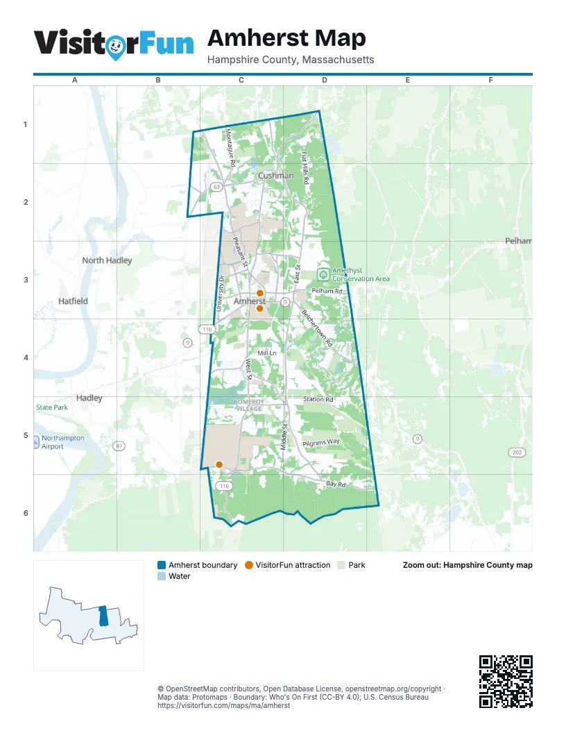
Street index of Amherst
Each street on the sheet and the grid squares it crosses.
- West StreetC4, C5, C6
- North Pleasant StreetC2, C3
- East Pleasant StreetC2, C3
- Belchertown RoadD3, D4
- South Pleasant StreetC3, C4
- Sunderland RoadC1, C2
- Montague RoadC1, C2
- Northampton RoadC3, C4
- Massachusetts AvenueC3
- Meadow StreetB2, C2
- College StreetC3, D3
- Triangle StreetC3
- Russell StreetC4
- Amherst RoadC1, D3, C6
- Long Plain RoadC1
- South East StreetD3, D4, D5, D6
- Bay RoadC5, D5, D6, E6
- North East StreetD2, D3
- University DriveC3, C4
- East Leverett RoadC1, D1
- Pine StreetC2
- Main StreetC3, D3
- Shays StreetC4, C5, D5
- Henry StreetC2, D2
- Lincoln AvenueC3
- Strong StreetC3, D3
- Pelham RoadD3
- Leverett RoadC1
- Pomeroy LaneC5, D5
- Amity StreetC3
- West Bay RoadC5
- Commonwealth AvenueC3
- Bridge StreetC1, C2
- Governors DriveC2
- Dickinson StreetC3
- Harkness RoadD4
- Roosevelt StreetB2
- Rocky Hill RoadC3
- Middle StreetC5, D5
- East Hadley RoadC4
- Thatcher RoadC2, C3
- Eastman LaneC2
- Fearing StreetC3
- North Whitney StreetC3
- Red Gate LaneC3
- Russellville RoadB2, C2
- Hills RoadC3
- South Whitney StreetC3
- Plumtrees RoadC1
- Comins RoadB2
- Station RoadD5
- Market Hill RoadC1, D1, C2
- Flat Hills RoadD1, D2
- Potwine LaneC5, D5
- Old Farm RoadD4
- Stony Hill RoadD3, D4
- Pilgrims WayD5
- Wildflower DriveD4, D5
- State StreetC1, C2
- South Campus DriveC5
- Pulpit Hill RoadC1
- West Pomeroy LaneC5
- Mill LaneC4, D4
- Echo Fill Access RoadD4
- Puffton Village DriveC2
- Cherry LaneC2
- Shutesbury RoadD2
- University Village DriveC2
- Hulst RoadD6, E6
- Sunset AvenueC3
- Larkspur DriveD4
- High Point DriveD1, D2
- Stanley StreetD4
- Pondview DriveC5
- Kendall DriveC5
- Linden Ridge RoadD4
- Snell StreetC4
- Woodlot RoadD4
- Heatherstone RoadD3
- Aubinwood RoadD3, D4
- Tillson Farm RoadC2, D2
- Grantwood DriveC2
- Rolling Ridge RoadC2
- Glendale RoadC5
- Mather DriveC2
- Greenleaves DriveC4
- 497 East Pleasant StreetC2
- Chestnut StreetC3
- Riverglade DriveC4
- Crocker Farm School DriveC4
- Regional High School DriveC3
- Columbia DriveC4
- Logtown RoadD4
- Mechanic StreetD5, D6
- Hicks WayC3
- Longmeadow DriveC5
- Summer StreetC2
- Farmington RoadC5
- Stagecoach RoadD6, E6
- Rambling RoadC5, C6
- Orchard Hill DriveC2, C3
- Gray StreetC3
- Concord WayD4
- Chapel RoadD5, D6
- Morgan CircleC2
- Rifle Range RoadD2
- Rolling Green DriveD4
- High StreetC3
- Blackberry LaneC2, D2
- Harris Mountain RoadD6
- Hop Brook RoadD4
- Snow Loop RoadD4
- Woodside AvenueC3, C4
- Sanderson LaneD6
- Presidential Apartments DriveC2
- Old Belchertown RoadD4
- North Campus DriveC5
- Tracy CircleC5
- Alpine DriveD3
- Kingman RoadC2, D2
- Iduna LaneD5
- Harlow DriveC2
- Olympia DriveC2
- Trillium WayD4
- Overlook DriveD1, D2
- Farview WayC2
- Cottage StreetC3
- Military RoadC6
- Gatehouse RoadD4
- Country Corners RoadC6
- Blue Hills RoadC3
- Greenwich RoadC5
- Spring StreetC3
- Deepwoods DriveC5
- Van Meter DriveC2
- Hawthorn RoadD4, D5
- Sand Hill RoadC2
- Mount Holyoke DriveC4
- Windmill LaneC2, C3
- East DriveC3
- Dana StreetC3
- Kestrel LaneD4
- Campus Center WayC3
- Natural Resources RoadC2, C3
- Aspen HeightsC4
- Carriage LaneC5
- Sheerman LaneC2
- Hunters Hill CircleC4
- Village LaneD3
- Presidents DriveC3
- Southpoint DriveC4
- Cowls RoadC2
- Justice DriveC4
- Owen DriveC2
- Tanglewood RoadD4
- Whippletree LaneC4
- Clark Hill RoadC3
- Elf Hill RoadE6
- QuadrangleC3
- Town House Apartments DriveC2
- Bayberry LaneD3
- McIntosh DriveC5, C6
- Kellogg AvenueC3
- McClellan StreetC3
- Mill StreetC1, C2
- Emily LaneC2
- South Middle StreetC5, C6
- Butterfield TerraceC3
- Maplewood DriveC3
- North Residential DriveC2
- Boltwood AvenueC3
- Brittany Manor DriveC4
- Lessey StreetC3
- South Mount Holyoke DriveC4
- Dennis DriveC4
- Summerfield RoadD4
- Churchill StreetC3
- Hawkins MeadowC4
- Jeffrey LaneC4
- Eames AvenueC3
- Tamarack DriveD4
- Yiddish Center WayC5
- Old Montague RoadC1
- Hillcrest PlaceC4
- Hitching Post RoadC2
- Memorial DriveC4
- Well Five RoadD6
- North Prospect StreetC3
- South Orchard DriveC5, D5
- Jenks StreetD3
- Amherst CrossingC3, D3
- Stockbridge RoadC3
- Teaberry LaneD4
- Valley View DriveC4, D4
- Pine HollowC2
- South Prospect StreetC3
- Centre Burying Ground RoadC3
- Holdsworth WayC2, C3
- Foxglove LaneD4
- Hedgerow LaneD3
- Southwest CircleC3
- Pomeroy CourtC5
- Salem StreetD3
- Hickory LaneD4
- Watson Farm RoadD3
- Spaulding StreetC3
- Winston CourtD4
- Hobart LaneC2
- Orchard StreetC3
- County CircleC3
- Merrill Science DriveC3
- Spencer DriveC5
- Taylor StreetC3
- Barrett Hill RoadC3
- Railroad StreetC3
- Flintlock LaneD4
- Alyssum DriveD4, D5
- Shumway StreetD3
- Arbor WayD3
- Webster CourtD4
- Seelye StreetC3
- Swallow Farms RoadD5
- Sutton CourtD4
- The Green At AmherstC4
- Sacco DriveC2
- Prescott RoadC5
- Charles LaneC3
- Chancellors DriveC3
- CrossbrookD4
- Canterbury LaneD6
- Research DriveD4
- Noah Webster CircleC3
- Ladyslipper CircleD4
- Boltwood WalkC3
- Chesterfield DriveC4
- Valley View CircleC4
- Power Plant RoadC3
- Echo Hill RoadD3
- Fairfield StreetC2
- University Drive SouthC4
- Poet's CornerD3
- McClure StreetC3
- Wildwood LaneC3
- Wentworth Manor DriveC4
- Berkshire TerraceC2
- Edgehill PlaceD4
- Weaver CircleC2
- Brandywine DriveC2
- Mattoon StreetC3
- Oak Knoll StreetD3
- Pokeberry RidgeC3
- Johnson Chapel RoadC3
- Moss LaneD4
- Pine Grove RoadD4
- Rosemary StreetC2
- The HollowD4
- Crestview Apartments DriveC2
- Indian Pipe LaneD4
- Mount Pleasant StreetC3
- Infirmary WayC3
- Moody Bridge RoadC5
- Harvard AvenueC3
- Old Town RoadC2
- Palley Village PlaceD4
- Brigham LaneC3
- Amity PlaceC3
- Jason CourtC2
- Forestedge RoadC2
- North Service RoadC2
- Hitchcock RoadC3
- Ridgecrest RoadC2
- Harris StreetC2
- Hartman RoadC2
- Bridle PathD3
- Puffer CircleC2
- Western LaneC5
- Sunrise AvenueC3
- Phillips StreetC3
- Eveningstar DriveC4, D4
- Hall DriveD4
- Maplewood CircleC3, D3
- Nutting AvenueC3
- Sherry CircleD5
- Oakwood CircleC2
- Kendrick PlaceC3
- Tyler PlaceC3
- Vista TerraceC6
- Allen Mill RoadD3
- Applewood LaneC5
- Juniper LaneD2
- Lilac LaneC2
- Chestnut CourtC3
- Morrow LaneC3
- Alpine CommonsD3
- Valley LaneC2
- Newell CourtC3
- Blossom LaneD5
- Canton AvenueC3
- Baker StreetC4
- Gaylord StreetC3
Things to do on the Amherst map
Places on the map
- Amethyst Brook Conservation Area
- Amethyst Conservation Area
- Amherst College
- Amherst Farm Supply
- Amherst Golf Club
- Amherst Transfer Station & Recycling Center
- Atkins Farm Conservation Area
- Atkins Flats Conservation Area
- Brickyard Conservation Area
- Cherry Hill Golf Course
- Cushman Brook Corridor
- Elf Meadow Conservation Area
- Fortier Conservation Area
- Hampshire College
- Hampshire College Farm
- Hickory Ridge
- Holyoke Range Conservation Area
- Larch Hill Conservation Area
- Lawrence Swamp
- Lawrence Swamp Conservation Area
- Mill River
- North Amherst Community Farm
- North Plum Brook Conservation Area
- Podick Cole Sanctuary
- Pomeroy Pond
- Puffers Pond
- Puffers Pond Conservation Area
- Simmons Farm Conservation Area
- Slobody Farm Conservation Area
- the oxbow
- UMass Orchards
- University of Massachusetts Amherst
- Upper Mill River Conservation Area
- W.E.B. Du Bois Library
- Water Supply Land
- Wellfields
- Wentworth Farm
- Wentworth Farm Conservation Area
- Wildwood Cemetery
- Wildwood Conservation Area
Next to Amherst
- Hadley
- Hatfield
- North Hadley
- Pelham
© OpenStreetMap contributors, Open Database License, openstreetmap.org/copyright · Map data: Protomaps · Boundary: Who's On First (CC-BY 4.0); U.S. Census Bureau















