

Massachusetts map
Carver map
About 11,817 people live here (Census Bureau, 2024 estimate). The sheet's index lists 255 streets; Main Street, Tremont Street and South Main Street cross the most grid squares. Also on it: Atwood Upper Reservoir, Carver Sportmans Club and Cole Property.
Open the map (PDF, US Letter)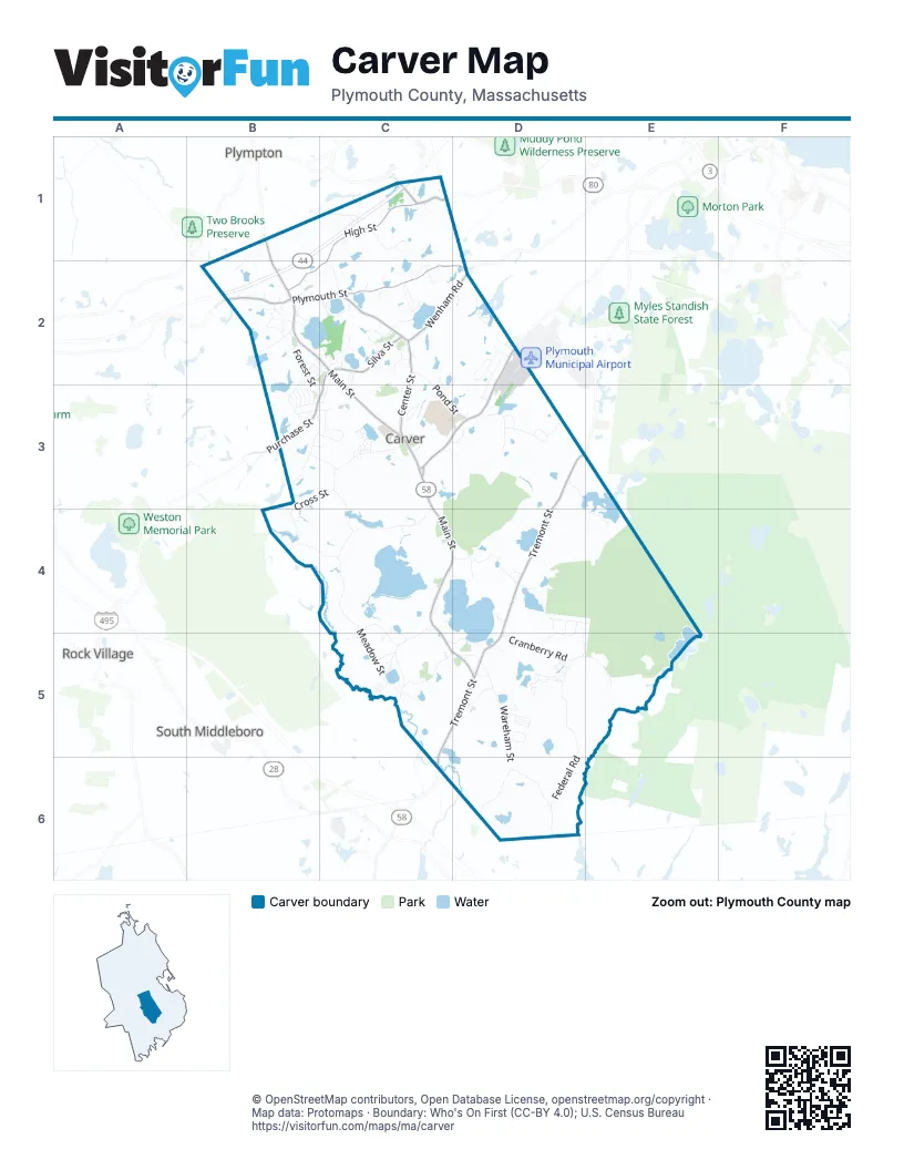
Street index of Carver
Each street on the sheet and the grid squares it crosses.
- Main StreetB1, C2, C3, C4, D4, D5
- Montello StreetB1, B2
- North Main StreetB1, B2, C2
- Park AvenueB1, B2
- Pleasant StreetB1, C1
- Autumn LaneC1
- Aveline DriveC1
- Brook StreetC1
- Ewell StreetC1
- Hard Hill RoadC1
- High StreetC1, B2, C2
- James Breech WayC1
- Manor Farm WayC1
- Nel Bonney RoadC1
- Orchard LaneC1
- Pleasant Street ExtensionC1
- Ricketts Pond DriveC1
- Samantha LaneC1
- Snappit RoadC1
- Solar CircleC1
- Spring StreetC1
- Spring Street ExtensionC1
- Stanley LaneC1
- Susan CircleC1
- Ann WayB2
- Arrowhead LaneB2
- Braddock WayB2
- Captain Perkins DriveB2
- Cole's Mill RoadB2
- Commerce WayB2
- Cordwood CircleB2
- Dump RoadB2
- Egypt RoadB2
- Forest StreetB2, B3
- Fuller StreetB2
- Great Meadow DriveB2, B3
- Green StreetB2
- Hines AvenueB2
- Lacey LaneB2
- Lakenham DriveB2
- Leonard StreetB2
- Lillian WayB2
- Linbi's PathB2
- Marion DriveB2
- Meeting House RoadB2, C2
- Old Main StreetB2, C2
- Plymouth StreetB2, C2, D2
- Pope StreetB2, B3
- Ransom StreetB2, B3
- Rickard StreetB2, C2
- Santana WayB2
- Sears StreetB2, B3
- Shaw StreetB2, B3
- Stone StreetB2
- Thatcher StreetB2
- Watson StreetB2
- Andrew's WayC2
- B a DriveC2
- Brockton AvenueC2
- Center StreetC2, C3
- Central AvenueC2
- Christopher CrossingC2
- Circuit AvenueC2
- Commons DriveC2
- Cranberry CircleC2
- Deacon LaneC2
- Douglas DriveC2
- Edgewood RoadC2
- Firlotte DriveC2
- Franklin RoadC2
- Front AvenueC2
- Gate StreetC2
- Gates StreetC2
- Godfray CircleC2
- Godfrey CircleC2
- Harvest View WayC2
- Holmes AvenueC2
- Hummock WayC2, C3
- Jill Marie DriveC2
- Johns Pond RoadC2
- Kestrel WayC2
- Mazzilli DriveC2
- Mills LaneC2
- Off Center StreetC2
- Old Center StreetC2, C3
- Pine City RoadC2
- Pond StreetC2, C3, D3
- Purchase StreetC2, B3, C3
- Quaker RoadC2
- Rainey WayC2
- Rambel Acres RoadC2
- Red Tail LaneC2
- Redtail LaneC2
- Richfield CircleC2
- Russell Trufant RoadC2
- Silva StreetC2
- Surrey DriveC2
- Swan Pond LaneC2, C3
- Tsina WayC2
- Walker RoadC2
- Walrit LaneC2
- Wenham RoadC2, D2
- Wenham Shores DriveC2
- White Pine LaneC2
- White Rock PathC2
- Woodlawn DriveC2, D2
- Bow StreetD2
- Bunnys RoadD2
- Carver RoadD2
- Eagle TerraceD2
- Fairway LandingD2
- Frank StreetD2
- Janes LaneD2
- McFarlin RoadD2
- Pondview WayD2
- Robbins PathD2, C3, D3
- South Meadow RoadD2, C3, D3
- Wade StreetD2
- Weathervane DriveD2
- Weston StreetD2, D3
- Atwood StreetB3, C3
- Beaver Dam RoadB3, C3
- Benson WayB3
- Callow StreetB3
- Craig StreetB3, C3
- Cross StreetB3, C3, B4
- Dunham StreetB3
- Eastman StreetB3
- Finney StreetB3
- Fosdick RoadB3, C3
- Fosdick StreetB3
- Jowett StreetB3
- Kaski StreetB3
- Laurie LaneB3, C3
- Lee WayB3
- Lucas StreetB3
- Murdock StreetB3
- Popes Point RoadB3, B4, C4
- Woodhaven StreetB3, C3
- Ash WayC3
- Barrows StreetC3
- Beech WayC3
- Birch TerraceC3
- Bisbee DriveC3, D3
- Canterbury DriveC3, D3
- Carver Square BoulevardC3
- Cedar DriveC3
- Chance CourtC3
- Cornish StreetC3
- Crescent RoadC3
- Crusader DriveC3, D3
- Crystal Lake DriveC3
- Dawn WayC3
- Doreen WayC3
- Hickory WayC3
- Holmes StreetC3, C4
- Jennifer LaneC3
- Maple DriveC3
- Meadow StreetC3, C4, C5
- Meadowbrook WayC3
- Oak DriveC3
- Peltola LaneC3
- Pine WayC3
- Roberts WayC3
- Russell Holmes WayC3
- The Yellow Brick RoadC3
- West StreetC3
- Williams DriveC3
- Boulton StreetD3
- Canterbury PathD3
- Flax Pond DriveD3
- Garden DriveD3
- Old Federal RoadD3, D4, E4
- Old South Meadow RoadD3
- Spruce CourtD3
- Stoneybrook WayD3
- Tremont StreetD3, D4, C5, D5, C6
- Village WayD3
- Ward StreetD3
- Ward Street ExtensionD3
- Briar Path WayB4
- France StreetB4
- Dump Road-southC4
- Eda AvenueC4, C5
- Maple Tree LaneC4, D4
- Paige CircleC4
- Pine StreetC4, C5
- Rochester RoadC4, C5
- Rocky RoadC4, D4
- Sampson LaneC4
- Saverys AvenueC4
- Shaw RoadC4
- South Main StreetC4, D4, C5, D5
- Bradford BoulevardD4, D5
- Brewster AvenueD4
- Crows Nest RoadD4
- John Alden CourtD4, D5
- Mayflower RoadD4
- Myles Standish DriveD4, D5, E5
- Pine Ridge WayD4
- Priscilla Mullens WayD4, E4
- Ridge RoadD4
- Town WayD4
- Halfway Pond RoadE4
- Lower College Pond RoadE4, E5
- Alexandra LaneC5
- Bates Pond RoadC5
- Catherine LaneC5
- Cherry Hill DriveC5
- Cobblestone LaneC5
- Daphne WayC5
- Everett StreetC5
- Heather LaneC5
- Indian StreetC5, D5
- Jabez Bridge RoadC5
- Jason DriveC5
- Lakeview StreetC5, D5
- Melanie LaneC5
- Morrissey DriveC5
- Rogers StreetC5
- Adams CircleD5
- Andrews Point RoadD5
- Beliveau LaneD5
- Carol StreetD5
- Cheryl LaneD5
- Church StreetD5
- Copper Lantern LaneD5
- Cranberry RoadD5, E5
- David RoadD5
- Deer Hill LaneD5
- Federal RoadD5, D6
- Irene DriveD5
- Island Farm RoadD5
- Jefferson WayD5
- Kennedy DriveD5
- Lincoln CircleD5
- Marks WayD5
- Michelle AvenueD5
- Old Forge DriveD5
- Old Forge ParkwayD5
- Patriot RidgeD5
- Pipers WayD5
- Pipers Way ExtensionD5
- President WayD5
- Roosevelt RidgeD5
- Seipet StreetD5
- Truman CourtD5
- Wareham StreetD5, D6
- Washington ParkD5
- William StreetD5
- Fearing Pond RoadE5
- Old East Head RoadE5
- Tihonet RoadE5
- Wankingo RoadE5
- Hammond StreetD6
Places on the map
- A Godfrey Bog Reservoir
- Atwood Lower Reservoir
- Atwood Upper Reservoir
- Barrett Pond
- Bates Pond
- Buccaneer's Bay
- Bumpus Bog
- Bumpus Bog Reservoir
- Carver Elementary School
- Carver High School Library
- Carver Middle High School
- Carver Sportmans Club
- Cole Property
- Cooper Pond
- Crane Brook Bog Reservoir
- Crane Brook Reservoir
- Dunham Pond
- East Head Bog Reservoir
- East Head Pond
- Edaville Entertainment Venue
- Federal Pond
- Former King Richards Faire
- Golden Field Pond
- Great Cedar Swamp
- Harwich Reservoir
- Johns Pond
- Muddy Pond
- Pinewood Way Campground
- Plymouth Road Pond
- Pond Street Pond
- Rocky Meadow Brook Pond
- Sampson Pond
- Shady Acres Campground
- Shaw Bog Reservoir
- So. Meadow Great Cedar Swamp
- South Meadow Brook Reservoir
- South Meadow Pond
- Vaughn Pond
- Wankinco River Reservoir
- Weweantic River Reservoir
Next to Carver
- Plympton
- Rock Village
- South Middleboro
© OpenStreetMap contributors, Open Database License, openstreetmap.org/copyright · Map data: Protomaps · Boundary: Who's On First (CC-BY 4.0); U.S. Census Bureau















