

Massachusetts map
Clinton map
About 15,740 people live here (Census Bureau, 2024 estimate). The sheet's index lists 246 streets; Main Street, Ridgefield Circle and Clamshell Road cross the most grid squares. Things to do inside the boundary: Icon Museum and Study Center.
Open the map (PDF, US Letter)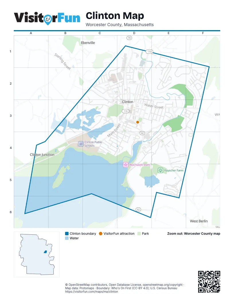
Street index of Clinton
Each street on the sheet and the grid squares it crosses.
- Mayflower DriveC1
- Myles Standish RoadC1
- Pilgrim RoadC1
- Adams RoadD1, C2, D2
- Allen StreetD1, D2
- Fuller StreetD1, D2
- High StreetD1, D2, D3
- Jewett CourtD1
- Longedge RoadD1, C2, D2
- Main StreetD1, D2, C3, D3, C4
- Martin StreetD1, D2
- Stone StreetD1, D2
- Brendan RoadE1, E2
- Craig DriveE1, E2
- Eileen AvenueE1
- Gorham AvenueE1
- John F Kennedy AvenueE1, E2
- Megan CircleE1, E2
- Milton AvenueE1
- Ridgefield CircleE1, F1, E2, F2
- Ross StreetE1
- Woodruff RoadE1, E2
- Fox Run DriveF1, F2
- Lancaster RoadF1, F2, F3
- Belmont AvenueC2
- Bristol AvenueC2
- BroadwayC2
- Broadway StreetC2
- Brook StreetC2, D2
- Catherine StreetC2
- Dewey StreetC2
- Flagg StreetC2, D2
- Greeley StreetC2, C3
- Harkins StreetC2
- Highland AvenueC2
- Highland StreetC2
- Lawrence StreetC2, D2
- Lydia LaneC2, C3
- Public RoadC2
- Rigby LaneC2
- Rigby StreetC2, C3
- Sand CourtC2
- Sterling StreetC2, D3
- View StreetC2
- Washington StreetC2, D2
- Willow StreetC2
- Willow Street ExtensionC2
- Alexander AvenueD2
- Boynton StreetD2
- Chestnut StreetD2, D3, D4
- Clark StreetD2, D3
- East StreetD2
- Forest AvenueD2
- Forest StreetD2
- Fuller CourtD2
- Goss StreetD2
- Grady StreetD2
- Hamilton StreetD2
- Henry StreetD2
- Laurel StreetD2
- Lewis StreetD2
- Liberty StreetD2
- Lowe StreetD2
- Maple StreetD2, D3
- Marshall StreetD2
- Myrtle StreetD2
- North Walnut StreetD2
- Olive StreetD2
- Parker StreetD2, D3
- Pearl StreetD2, D3, E3
- Plain StreetD2
- Roma StreetD2
- Russell PlaceD2
- Walnut StreetD2, D3
- West StreetD2, D3
- Worcester StreetD2
- Elm StreetE2, E3
- Hillside AvenueE2
- McMahon AvenueE2
- Nathan DriveE2
- Reisner WayE2, E3
- Walden TerraceE2
- Bear PathF2
- Blossom StreetF2, F3
- Bobcat LaneF2
- Colonial DriveF2
- Deer Run CircleF2
- Horseshoe LaneF2
- Kent StreetF2
- Lincoln StreetF2
- Lorraine AvenueF2
- Mount View DriveF2, F3
- Otis StreetF2
- Oxbow CircleF2
- Pheasant LaneF2
- Fitch RoadB3, C3
- South Meadow RoadB3, B4
- Sprague RoadB3
- Stonebridge CircleB3
- Beacon StreetC3, D3, D4
- Coachlace StreetC3, D3
- Harbor StreetC3
- Kittredge PlaceC3
- Lakeside AvenueC3
- New Harbor RoadC3, D3
- Pine StreetC3
- Pine Street ExtensionC3
- Rigby PlaceC3
- Rogers Field WayC3
- Summit StreetC3, D4
- Watson PlaceC3
- Wilkate PlaceC3
- Woodlawn StreetC3
- Ash StreetD3
- Battista CourtD3
- Burdett StreetD3
- Cedar StreetD3, E3
- Church StreetD3, E3
- Clinton StreetD3, D4
- Depot SquareD3
- Dogget CourtD3
- Franklin StreetD3, D4
- French TerraceD3
- Green StreetD3, E3, D4
- Grove StreetD3, D4
- Hammond StreetD3
- Haskell AvenueD3, E3
- Leighton AvenueD3
- Mechanic StreetD3
- Nelson StreetD3
- Norman StreetD3
- Palmer CourtD3
- Park StreetD3, C4, D4
- Pierce PlaceD3
- Pleasant StreetD3
- Pond CourtD3
- Prescott StreetD3, E3
- Prospect StreetD3
- Richardson PlaceD3
- Ring StreetD3
- School StreetD3
- Union StreetD3
- Water StreetD3, E3, F3
- White CourtD3
- Auburn StreetE3
- Barrett StreetE3
- Beech StreetE3
- Benefit StreetE3
- Birch StreetE3
- Bourne StreetE3
- Branch StreetE3
- Centennial StreetE3
- Chace StreetE3, F3, E4
- Chipman StreetE3, F3
- Cromie StreetE3, F3
- Francis StreetE3, E4
- Harris StreetE3, F3
- Larch StreetE3
- Oak Hill AvenueE3
- Oak Ridge DriveE3, E4
- Oak StreetE3, D4, E4
- Orange StreetE3
- Sanderson PlaceE3
- Schley StreetE3
- Schobert StreetE3, F3
- Spruce StreetE3
- Vale StreetE3
- Williams StreetE3
- Wittig CourtE3
- Acre RoadF3
- Bolton RoadF3
- Bufton Farm RoadF3, F4
- Hugh StreetF3
- Jackie WayF3
- Watoquadoc RoadF3
- West Boylston StreetA4, B4, C4
- Pond View DriveB4, C4
- Arthur StreetC4, D4
- Dennis StreetC4, D4
- Dike DriveC4
- Front StreetC4, D4
- John StreetC4, D4
- Lane AvenueC4
- Nugent AvenueC4
- Spring StreetC4
- Terrence AvenueC4
- Thomas StreetC4
- Vineyard AvenueC4
- Winter StreetC4, D4
- Winthrop StreetC4
- Acre CourtD4, E4
- Acre StreetD4, E4
- Boylston StreetD4, D5, D6
- California CourtD4
- Cameron StreetD4, E4
- Clamshell RoadD4, E4, D5, E5
- Eagle NestD4
- Fairmount StreetD4
- Fairview StreetD4
- Gabby LaneD4
- Gage StreetD4
- Hastings CourtD4
- Hill StreetD4
- Ledge CourtD4
- Nashua StreetD4
- Oak CourtD4
- Richman StreetD4
- River RoadD4, D5
- Simon CourtD4
- Skyline DriveD4
- Top StreetD4, E4
- Wilson StreetD4, E4, D5
- Acorn StreetE4
- Berlin StreetE4, E5
- Candice StreetE4, F4
- Clintwood DriveE4
- Coyne StreetE4
- Crown StreetE4
- James StreetE4
- Kilmurray StreetE4
- Lindbergh StreetE4
- North StreetE4
- Robert Memorial DriveE4
- Robert StreetE4
- Town Lyne LaneE4
- Webster StreetE4
- Mulberry DriveD5
- Applewood LaneE5
- Boxwood LaneE5
- Briarwood LaneE5
- Candlewood LaneE5
- Cherrywood LaneE5
- Clinton AvenueE5
- Crestwood LaneE5, E6
- Devenwood WayE5
- Fernwood LaneE5
- Hazelwood WayE5
- Kenwood WayE5
- Ledgewood WayE5
- Linwood CourtE5
- Southwood LaneE5, E6
- Sprucewood LaneE5
- West Ledge RoadE5
- Woodland CircleE5
- Willow RoadD6, E6
- Boylston RoadE6
Things to do on the Clinton map
Places on the map
- Apple Country Market
- Apple Valley Conser. Easement
- Bigelow Free Public Library
- Burdett Hill
- Central Park
- Clamshell Pond
- Clinton Bluff Natural Heritage Area
- Clinton District Court
- Clinton Elementary School
- Clinton Police Station
- Clinton Presbyterian Church
- Clinton Public Schools
- Clinton Town Hall
- Coachlace Pond
- CVS Pharmacy
- Fuller Field
- Hamilton Square
- Hannaford
- Lakside Field
- Lancaster Mill Pond
- Maybarton Community Garden
- McNally & Watson Funeral Home
- Morning Glory Farm
- Mossy Pond
- Philbin Memorial Park
- Philip Weihn Memorial Swimming Pool
- Rattlesnake Hill
- Rauscher Farm
- Saint John the Evangelist Church
- Saint Nicholas Greek Orthodox Church
- Savage Field-Vale Street
- South Meadow Pond
- Turner Hall
- Umass Memorial-Clinton Hospital
- Wachusett Dam
- Wachusett Spillway
- Walgreens
- Wilson Hill
- Woodlawn Cemetery
Next to Clinton
- Ebenville
- West Berlin
© OpenStreetMap contributors, Open Database License, openstreetmap.org/copyright · Map data: Protomaps · Boundary: Who's On First (CC-BY 4.0); U.S. Census Bureau















