

Massachusetts map
Fall River map
About 94,689 people live here (Census Bureau, 2024 estimate). The sheet's index lists 89 streets; North Main Street, Western Fall River Expressway and Riggenbach Road cross the most grid squares. Things to do inside the boundary: Battleship Cove and Lizzie Borden House.
Open the map (PDF, US Letter)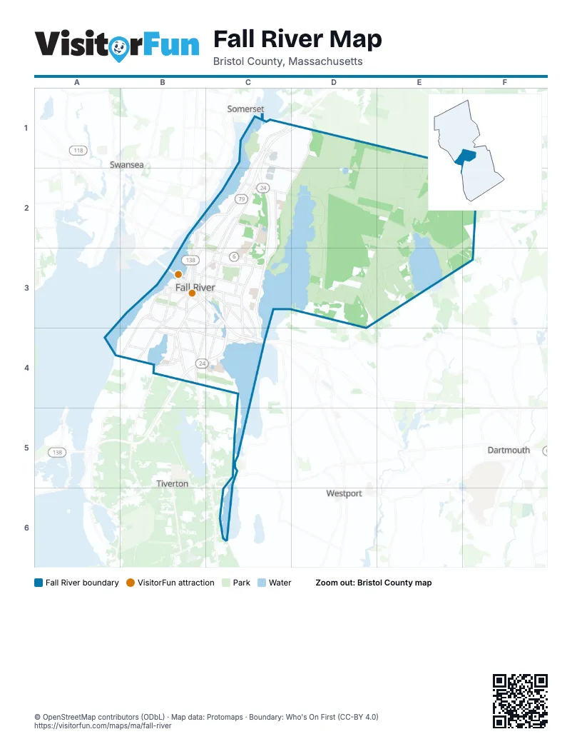
Street index of Fall River
Each street on the sheet and the grid squares it crosses.
- Airport RoadC1, D2
- Airport Road RotaryC1
- Amvets HighwayC1, D1
- North Main StreetC1, B2, C2, B3
- Western Fall River ExpresswayC1, B2, C2
- Innovation WayD1
- Riggenbach RoadD1, C2, D2
- Brightman StreetB2, C2
- Davol StreetB2, B3
- Grand Army of the Republic HighwayB2
- President AvenueB2, B3, C3
- Elsbree StreetC2, C3
- Highland AvenueC2, B3, C3
- Meridian StreetC2, C3
- Robeson StreetC2, C3
- Valentine StreetC2
- Wilson RoadC2
- Quanapoag RoadF2
- Almond StreetB3
- Anawan StreetB3
- Bay StreetB3, B4
- Bedford StreetB3, C3
- Borden StreetB3
- BroadwayB3
- Broadway ExtensionB3
- Central StreetB3
- Chace StreetB3
- Columbia StreetB3
- Connector StreetB3
- Durfee StreetB3
- Ferry StreetB3
- Fourth StreetB3
- Globe StreetB3, B4
- Hartwell StreetB3
- Henry V Seneca DriveB3
- High StreetB3
- Locust StreetB3, C3
- Lyon StreetB3
- Middle StreetB3
- Milliken BoulevardB3
- Milliken Boulevard ConnectorB3
- Old Colony StreetB3
- Pleasant StreetB3, C3, C4
- Plymouth AvenueB3, C3, B4
- Pocasset StreetB3
- Ponta Delgada BoulevardB3
- Rodman StreetB3, C3, B4
- Second StreetB3
- Seventh StreetB3
- South Main StreetB3, B4
- Stafford RoadB3, B4
- Sullivan DriveB3
- Third Street NorthB3
- Troy StreetB3
- Turner StreetB3
- Warren StreetB3, C3
- Water StreetB3
- Water Street ConnectorB3
- William StreetB3
- County StreetC3, C4
- Eastern AvenueC3, C4
- Eastern Avenue NorthC3
- Jefferson StreetC3, C4
- New Boston RoadC3
- North Eastern AvenueC3
- Oak Grove AvenueC3
- President Avenue RotaryC3
- Quarry StreetC3
- Quequechan StreetC3
- Thirteenth StreetC3
- Twelfth StreetC3
- Willow StreetC3
- Brayton AvenueB4, C4
- Dwelly StreetB4
- Fish RoadB4
- Laurel StreetB4
- Main RoadB4
- Mariano Bishop BoulevardB4
- Mariano S Bishop BoulevardB4
- Mount Hope AvenueB4
- Newton StreetB4
- Rhode Island AvenueB4
- Stockton StreetB4
- Tucker StreetB4
- William S Canning BoulevardB4
- Martine StreetC4
- McGowan StreetC4
- American Legion HighwayC5
- Bulgarmarsh RoadC5
Things to do on the Fall River map
Places on the map
- Atlantis Charter School
- Battleship Cove
- Beth El Cemetery
- Bicentennial Park
- Bleachery Ponds
- Boardwalk Crossing
- Bristol County
- Britland Park
- Charlton Memorial Hospital
- Chew Field
- Cook Pond
- Copicut Hill
- Copicut Reservoir
- Copicut Reservoir Watershed
- Copicut Woods
- Cottages at Bay View
- Crossroads at 24
- Doctor's Mill Pond
- Dumont Field
- Edmond P. Talbot Middle School
- Fall River
- Fall River Country Club
- Fall River Heritage State Park
- Fall River Landfill
- Fall River Law Library
- Fall River Public Library
- Fall River Public Schools
- Fall River Shopping Center
- Father Travossos Park
- Father Vincent Francis Diaferio Village
- Flint Post Office
- Freetown Fall River State Forest Hunting Area
- Hebrew Cemetery
- Henry Lord Community School
- Highland Station Post Office
- James Tansey Elementary School
- Kennedy Park
- King Philip's Swamp
- Lafayette Park
- Learning Resources Center
Next to Fall River
- Dartmouth
- Somerset
- Swansea
- Tiverton
- Westport
© OpenStreetMap contributors (ODbL) · Map data: Protomaps · Boundary: Who's On First (CC-BY 4.0)