

Massachusetts map
Hanover map
About 14,887 people live here (Census Bureau, 2024 estimate). The sheet's index lists 300 streets; Washington Street, Broadway and Main Street cross the most grid squares. Also on it: Cardinal Cushing School, Colby/Phillips Property and Factory Pond.
Open the map (PDF, US Letter)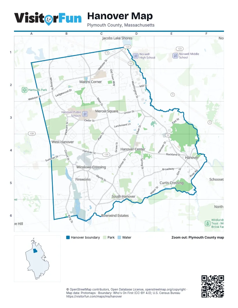
Street index of Hanover
Each street on the sheet and the grid squares it crosses.
- Pilgrims HighwayC1, D1
- Pilgrim HighwayC1
- Washington StreetD1, D2, D3, E3, E4, F4, F5
- Webster StreetC1, D1, A2, B2, C2
- Columbia RoadE4, F5
- BroadwayE4, F4, C5, D5, E5, C6, D6
- Hanover StreetB4, C4, D4, E4
- Main StreetB1, C1, C2, C3, C4, D4
- Center StreetD4, C5, D5, C6
- Winter StreetC5, C6
- Rockland StreetE4
- Circuit StreetB4, C4, B5, C5
- Whiting StreetB1, A2, B2, B3
- King StreetB4, B5, B6
- Cedar StreetB3, C3
- Plain StreetC3, C4
- Silver StreetD3, D4
- Union StreetC3, D3
- Myrtle StreetC5
- Pleasant StreetB3, B4
- Spring StreetD4, D5
- Elm StreetE5
- West AvenueB3
- Cross StreetC5, D5, D6
- Summer StreetB4
- Old Washington StreetD3
- Mill StreetD2
- School StreetB5
- Old Town WayC1, C2, D2
- Water StreetD5, E5
- Woodland DriveC1, C2, D2
- Old Farm RoadB3, C3, B4, C4
- Dillingham WayC2
- Grove StreetC4, D4
- Candlewood LaneD4
- East StreetE3
- Brook CircleB3, B4
- Hanover Mall DriveD1, D2
- Manns DriveC2
- Ponderosa DriveA2, B2
- Ledgewood DriveB2
- Old Forge RoadB6
- Larchmont LaneC3, D3
- Twin Fawn DriveD4
- King Hill RoadB5, B6
- Stonegate LaneC3, D3
- Cushing Hill RoadB1, B2
- American Elm AvenueB1
- River RoadE5, F5
- Hearthstone WayD3
- Birchwood RoadD3, D4
- Homestead LaneB3
- Cedarwood RoadB2, C2
- Old Schoolhouse LaneA3, B3
- Shingle Mill LaneB2
- Briarwood DriveB6
- Stone Meadow LaneC2, C3
- Hacketts Pond DriveB2, C2
- Mayflower CircleC4
- Tecumseh DriveC5
- Colonial DriveC3, C4
- Curtis Mill LaneB2
- Laurie LaneE4, D5, E5
- Factory Pond RoadB6, C6
- Hillside DriveC4, C5
- Samoset DriveC5
- Dwelley AvenueA2
- Walnut StreetC1
- Pine Tree DriveD4, D5
- Meadowbrook RoadC2
- Country RoadB2
- Plymouth RoadC5, D5
- Longwater DriveB3, C3, B4
- Sconset WayE3
- Brookwood RoadB2, C2
- Bardin StreetE5
- Bates WayB2, C2
- Maplewood DriveD3
- Juniper LaneC1, C2
- Fair Acres DriveB4, C4
- Forest StreetB2, B3
- Wearguard DriveB4, C4
- Donna DriveD3, D4
- North StreetB2
- Pond StreetD3
- Industrial WayB5
- Richard DriveC5
- Great Rock RoadB2
- Waterford DriveC6
- Setterland Farm RoadC2
- Hillside CircleC4, C5
- Pine StreetD2, D3
- Tower Hill DriveD2, D3
- Cheryl LaneE5
- Mill Pond DriveD2
- Pleasant Woods LaneB3, B4
- Read DriveD4
- Bartlett RoadD3, E3, D4
- Graham Hill DriveD5
- Brookbend RoadE3
- Heritage WayC4, D4, C5
- Deerfield LaneA1, B1
- Chestnut StreetD2
- Clark CircleB6
- Bradford RoadD5
- Arbor PathC4
- Oakland AvenueE4, F4
- Paul RoadC2
- Ames WayB5, C5
- Anderson Farm LaneB3
- Mayflower DriveB4
- Indian Head DriveE5
- Wood Hollow WayB6
- Tucker RoadC3
- Buffum RoadB1, B2
- Franklin RoadB3, B4
- Old Bridge RoadF4
- Spring Meadow LaneC4
- Folly Hill LaneD4, E4
- Hoover RoadB4
- Oldfield DriveA2
- Linden LaneB2
- Cricket's RunE3
- Jefferson RoadB3, B4
- Saltwind DriveD5
- Karen RoadE5
- Legion DriveD4
- Holly Berry LaneB2
- Phillips StreetC1
- Push Cart LaneB1
- Sunset PointC6
- Deborah RoadD3
- Henrys LaneD2
- Buttonwood LaneF4
- Saddle LaneE5
- Cape Cod LaneB4, C4
- Bayberry LaneB2, B3
- Old Cross StreetC5
- Milestone WayE3, E4
- Gail RoadC5
- Willow RoadD5
- Buttercup LaneC2, C3
- Town Line DriveB1
- Pondbrook DriveB2
- Olde Forge RoadB6
- King Phillip LaneC5
- Birch DriveC5
- Ridge Hill DriveC3
- Lally Farms DriveC1
- Maple AvenueB3
- Thorny Meadow WayB3
- Hawthorne RoadC4
- Beckford Farm RoadB1
- Sequoia LaneC5
- Gardner WayB2, B3
- Rosaria LaneC3
- B StreetB5
- Damon RoadB2
- Old Barn RoadC2
- Davis StreetC2
- Russell RoadB5
- Village LaneA3
- Phillips LaneB4, C4
- Elmwood Farm DriveE4
- Honeysuckle LaneA2
- Longwood LaneE3, D4, E4
- Massasoit LaneC5
- Windward LaneC2
- Bard Rock LaneB1
- Hickory LaneC4
- Clapp RoadE5
- Jay's LaneD3
- Assinippi AvenueD1
- Pat RoadC5, C6
- Sheila WayD4
- Henderson LaneC2
- Vine StreetA2
- Dana DriveD5
- Cornet Stetson RoadC5, D5
- Trailside LaneD5
- Broad Oak WayE4, E5
- Curtis RoadD2
- Tyler LaneA1, A2
- Absolom WayB2
- Miller's LaneC5
- Great Acres DriveB6
- Rawson RoadE3
- Herring Brook WayE4
- Hemlock CircleC2
- Gray Beech LaneC4, D4
- Beech Tree RoadD5
- Tolman RoadE5
- Winslow DriveC4
- Old Elm StreetE5
- Osprey LaneB5
- James RoadD3
- Riverside DriveE5
- Birchwood DriveD3
- Alden RoadD5
- Pantooset RoadF5
- Church StreetE4
- Lincoln LaneB4
- Bailey RoadC3
- Monroe RoadB3, B4
- Bonney LaneB2
- Nash LandingD4
- Jackson RoadB4
- Old Shoolhouse LaneA3
- Cherry Blossom LaneB1
- Linwood TerraceD4
- Buena Vista WayC3
- Meeting Hill LaneC3
- Cedarcrest RoadC3
- Pine Island RoadB4
- Kingston RoadD5
- Tindale WayD4
- Bittersweet LaneD4
- Lantern LaneD4
- Wilder LaneB6
- Stacy LaneC5
- Nathan's HillF4
- Teresa LaneD5
- Cobblestone LaneD3
- Stockbridge RoadC5
- Aspen DriveC3
- Spruce WayD2
- Winterberry LaneB1
- Sellon PlaceB4
- Frank's LaneD2
- Old Shipyard LaneF4
- Blue Spruce LaneC2, D2
- Ash LaneC3
- Pocahontas LaneC5
- Sunnyside AvenueB5
- Meadow DriveD5, D6
- Xhengo LaneC2
- Fieldstone LaneD3
- Townsend Woods DriveB5
- Evergreen LaneB4
- Sproul RoadD5, E5
- Berry StreetC1
- Josiah's LaneC5
- Hammer Hook DriveC4
- Azalea WayB2
- Tilden LaneB5, B6
- Howland ParkD2
- Old Webster StreetC1
- Sharon DriveD5
- Simmons RoadC2
- Rose Hill RoadB2
- Post DriveC3
- Constitution WayD3
- Arthur Matthew DriveD5
- Laurel LaneB3
- Studley LaneC4
- Tiffany Mill LaneC6
- Summersweet CircleB1
- Ancestor AvenueC2
- Cranberry LaneE5
- Spruce CircleC2, D2
- Pond Brook DriveB2
- Woodruff PlaceB2
- Brewster LaneD5
- Shoe Cottage LaneB2
- Pumpkin Patch WayB1
- Woodbine CircleC1, C2
- Whistle Berry CircleB2
- Jutila Farm PathC3
- Homer RoadC4
- Roberts RoadA2
- Winstanley WayB2
- Elijahs PathD5
- Ellis AvenueC1
- First Parish LaneE4
- Wade WayB1
- Mill Brook WayB3
- Ingle LaneB6
- Beechnut CircleD2
- Briggs LaneB6
- Sugar Maple CircleB1
- Greenhill RoadD5
- Ann Marie LaneC4, D4
- Kendrick WayE4
- Estes RoadC4
- Kimberly LaneB3
- Foxtail RoadA2
- Academy AvenueE4
- Barstow AvenueE4
- Virginia DriveA2, B2
- Bishop LaneA2
- Autumn LaneB1
- Acorn CircleD2
- Merritt RoadC2
- Indian Brook LaneC5
- Saturn DriveD1
- Old Icehouse LaneB2, C2
- Chestnut CircleD2
- Te Berry Farm RoadD5
- Brisco's PlainC3, C4
- Crosby LaneD3
Places on the map
- Bonney Conservation Land
- Briggs Stable
- Cardinal Cushing School
- Center Elementary School
- Clark Land
- Colby/Phillips Property
- Conservation Land
- Dillingham Site
- Ellis Playground
- Emilson YMCA
- Emily Eliz. White Cons. Area
- Factory Pond
- Fireworks Property
- Forge Pond
- Four Winds Farm
- Hackett Pond
- Hall Park
- Hanover Cemetery
- Hanover Crossing
- Hanover Post Office
- Hanover Public Schools
- Hell Swamp
- Hobart Swamp
- Indian Head River
- Inhabitants of Plymouth County
- Iron Mine Brook Nature Preserve
- Luddams Ford Park
- Melody Woods
- Merry Property
- National Fireworks Property
- Old Pond Swamp
- Peg Swamp
- Plain St. Site
- Rinear Property
- River Path Conservation Area
- Starland Sportsplex & Fun Park
- Summer St. Conservation Area
- Third Herring Brook
- Wampum Swamp
- Water Protection Land
Next to Hanover
- Assinippi
- Jacobs Lake Shores
- Riverwind Estates
- Rye Hill
- Schoosett
- Wingbrook Estates
© OpenStreetMap contributors, Open Database License, openstreetmap.org/copyright · Map data: Protomaps · Boundary: Who's On First (CC-BY 4.0); U.S. Census Bureau















