

Massachusetts map
Harwich map
About 13,620 people live here (Census Bureau, 2024 estimate). The sheet's index lists 300 streets; Main Street, Mid Cape Highway and Orleans Road cross the most grid squares. Also on it: Bell’s Neck Conservation Lands, Coys Brook and Cranberry Valley Golf Club.
Open the map (PDF, US Letter)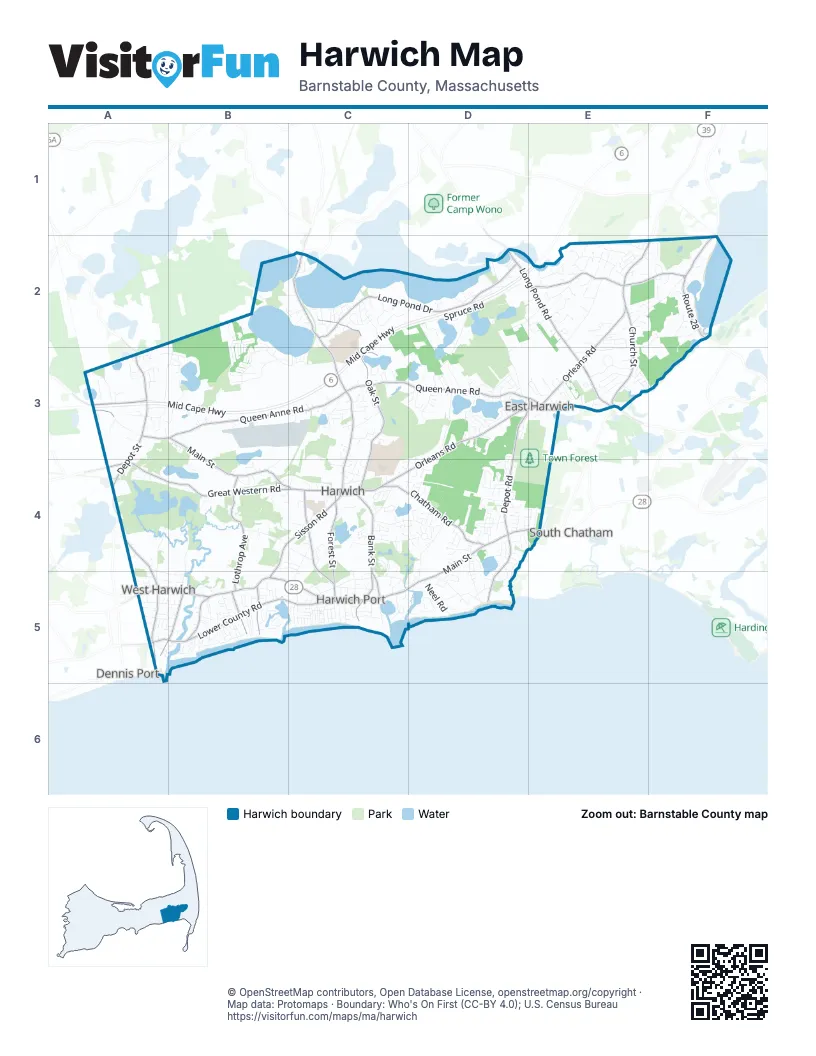
Street index of Harwich
Each street on the sheet and the grid squares it crosses.
- Mid Cape HighwayC2, D2, E2, A3, B3, C3
- Main StreetA3, B3, B4, C4, D4, E4, A5, B5, C5, D5
- Orleans RoadE2, F2, D3, E3, C4, D4
- Pleasant Lake AvenueC2, C3, C4
- Long Pond RoadD2, E2, E3
- Sisson RoadB4, C4, B5
- Route 28F2
- Route 137E3
- Old Queen Anne RoadE3
- Harwich RoadC2
- Route 28-Head of the Bay RoadF2
- Queen Anne RoadA3, B3, C3, D3, E3
- Long Pond DriveC2, D2
- Lower County RoadA5, B5, C5
- Great Western RoadA4, B4, C4
- Pleasant Bay RoadE2, F2
- Depot StreetA3, A4, B4
- Chatham RoadA3, C4, D4
- Depot RoadD3, E3, D4
- Church StreetE2, E3
- Slough RoadA3
- Meetinghouse RoadE3
- Oak StreetC2, C3, C4
- Bank StreetC4, C5
- Lothrop AvenueB4, B5
- South StreetC4, C5
- Forest StreetC4, C5
- Belmont RoadA5
- Uncle Venies RoadD4, D5
- Riverside DriveA5, B5
- Depot Road WestA4, A5
- Old Chatham RoadA3
- Chase StreetB5
- Brooks RoadB5
- Earle RoadB5
- Freeman StreetC5
- Spruce RoadD2, E2
- Bay RoadE2, F2, E3
- Seth Whitefield RoadD2, D3
- Round Cove RoadD2, E2
- Headwaters DriveB3, C3
- Division StreetA4, A5
- Nathan Walker RoadD2, D3
- Gorham RoadC4, D4, D5
- North RoadB4, B5
- Long RoadC4, D4
- Gilbert LaneB4, C4
- Factory RoadA3, B3, B4
- Kendrick RoadE2, F2
- John Joseph RoadD3
- Bell Neck RoadA4, B4
- Courtney RoadC2
- North Westgate RoadB2, A3, B3
- Cottonwood RoadC2
- Miles StreetC5
- Azalea DriveB2, B3
- Deep Hole RoadD4, D5
- Bells Neck RoadA4, A5
- John Nelson WayC4
- Cemetery RoadE3
- Parallel StreetC4
- Halls Path OneE2
- Captain Bearse LaneE3
- Hoyt RoadC5, D5
- Dundee CircleD4
- Grey Neck RoadB5
- Standish Woods CircleE2
- Continental DriveE3
- Blueberry LaneB3
- Julien RoadD5
- Pleasant RoadB5
- Saquatucket Bluffs RoadD5
- Doane RoadC4, C5
- Clearwater DriveD3
- Punkhorn RoadB2, C2
- Lovers LaneC4
- Neel RoadD5
- Bog LaneA3, B3
- Lakewood DriveC2
- Pleasant StreetC5
- Shore RoadB5
- Willow StreetA5, B5
- Sequattom RoadC2
- Martha's LaneD4
- Noreast DriveE3
- Crocker RiseE2
- Squantum PathA3, B3
- Oliver Snow RoadD4
- Idle WayD3
- Archibald CircleB5
- Schooner DriveD5
- Hillcrest DriveD3
- Main Street ExtensionA3
- Driftwood LaneD3, D4
- Ryder RoadA3
- Smith StreetA4, A5, B5
- Williamsburg AvenueE2, E3
- Cornerwood DriveC4
- Red River Beach RoadD5
- Baker's DriveC3
- Sugar Hill DriveE3, F3
- Kelley RoadA5, B5
- Old Harwich Brewster RoadA3
- Aladoe Farm RoadD3
- Salt Meadow LaneB5
- Souwest DriveE3
- Kimberley WayE2
- Whidah DriveE3
- Walden WayE2
- Echo Woods RoadD4
- Harbor RoadC5
- Pine Knoll RoadC4
- Christopher WayE2, F2
- Mill Pond RoadD2
- Nons RoadB5
- Old County RoadD4
- Pine LaneB5
- Ridgeport DriveD4
- Wilmas WayE2
- Glenwood DriveD3
- Davis LaneC5
- Partridge LaneE2
- Sherwood RoadE2
- Olde Homestead WayE2
- Harding LaneE2
- Huckleberry PathE2
- Blue Heron LandingF2
- Wequassett RoadB5
- Bog Hill RoadB2
- Cahoon RoadD2
- Robins Pond RoadB3
- Pleasant Bay CourtF2
- Halls PathE2
- Obed Brooks RoadD3
- Hidden Pond CircleD3
- Monomoy RoadB5
- StrandwayB5
- Nehoiden StreetB5
- Walkerwoods DriveD2
- Littlefield Pond RoadA3
- Snow Inn RoadC5
- Lynch LaneA3
- Vineyard LaneB4
- Skippers DriveD4
- Sterling RoadD4
- Lakeview DriveC3
- Ginger Plum LaneB5
- South Chatham RoadD5
- Old Wharf RoadD5
- Patricia LaneB5
- Wah Wah Taysee RoadC5
- Rainbow WayD3
- Somerset RoadE3
- Hillside RoadE4
- Wales RoadD3
- Indian TrailD4
- Spinnaker LaneD5
- Fernwood CircleD4
- Beach Plum CircleD3
- Chris Jobeth CircleE2
- Dunes RoadB5
- Braddock LaneC5
- Englewood DriveC4
- Purmackene LaneD4
- Grist Mill RoadE2, C4
- Mary Beth LaneE2
- Robert RoadD4, E4
- Buttonwood RoadC2
- Har-Woods AvenueC3
- Harold StreetB4, C4
- Joe Lincoln RoadA5, B5
- Js PathD3
- Aaron's WayC3
- Robbins RoadC4
- McGuerty RoadF2
- Park StreetC4
- Jesse Eldredge RoadD4
- Johanna's PathE3
- Cross StreetC5
- Mill RoadC5
- Proprietors WayB2
- South Westgate RoadA3, B3
- Arthur's WayE3
- Elijah's WoodsE2
- Sea StreetC5
- Ocean AvenueC5
- School House DriveC4
- Old Colony RoadC4
- Pine Grove RoadA5
- Wyndemere Bluffs RoadC5
- Beriah Brooks RoadC4
- Sea Breeze AvenueC5
- Driftwood CircleD4
- Hiawatha RoadC5
- Pine StreetC5
- Third StreetC2
- Grassy Pond RoadC4, C5
- Sandpiper RoadD4
- Argyle WayD3
- Spruce Grove RoadE2
- Great Woods RoadD2
- Joshua Jethro RoadD4
- Sidney RoadD2
- Vacation LaneD3
- Hersey RoadD5
- Pilgrim RoadC5
- West Tupelo DriveB3
- Westwon WoodsC4
- Pine Orchard RoadE2
- Fairways DriveC3
- Daluze DriveC3, D3
- Tody Bole LaneC4
- Seahorse RoadD4
- Deacons Folly RoadB3, B4
- Herring Run RoadA4
- Jay Z DriveD3
- Ridgevale RoadD4
- Charles RoadD4, E4
- Moody RoadC4
- Scotlin WayF2
- Robins WayC3
- Cypress PointE3
- Lakeway LaneD3
- Gomes WayD4
- Chestnut LaneE2
- Ellens WayC3
- Red Pine DriveC3
- Walton RoadD4
- Green Needle LaneB5
- Hall AvenueB5
- Kildee RoadC5
- Mirasol LaneB5
- Veterans Memorial DriveE3
- Skinequit RoadD4
- Cranberry LaneC4
- Evergreen WayA3
- Pinewood LaneB5
- Follows RoadC3
- Derby LaneA3
- Elm DriveE2
- Quail Nest RunD3
- Harvest Hollow DriveC4
- Wendys WayC3
- Shore DriveA3, B3
- Bassett Woods RoadB4
- Bay View RoadC5
- Sadie's WayE2
- Water RoadD4
- Wooncepit RoadB4, C4
- Lincoln Village RoadC5
- Rocky WayB4, C4
- Harwich PinesD2
- Elinor WayA5, B5
- Seventh StreetC2
- Cherokee RoadD3
- Marlin RoadD4
- Quaker LaneD4
- Ayer LaneC5
- Old Brewster RoadB4
- Oakleaf CircleC3
- Speak WayA3
- Betty's LaneC3
- Forsythia DriveC2
- Connecticut AvenueF2
- Eagle's Nest RoadF2
- Auston RoadE3
- Haromar HeathD3
- Old Heritage WayE3
- Walther RoadD5
- Belmont AvenueA3
- Crowell RoadD4, D5
- Red River RoadD4
- Sandy LaneD3
- Live Oak DriveE2
- Sea WayB5
- Shore Road ExtensionB5
- Alder LaneB2, B3
- Samoset RoadD3
- Zylpha RoadC5
- Old Carriage DriveE2
- Fredericksburg AvenueE2
- Our RoadA3
- Princes StreetD4
- Woodland RoadC5
- Bittersweet LaneB3, A5
- Earle TerraceB5
- Jasper Moore TrailE2
- Mary Willet CourtE2
- Deacon Folly RoadB4
- Duke Ballem RoadC2
- Locust Grove RoadE3
- Vicksburg AvenueE2
- Lydia Bangs WayE2
- Deerfield RoadA4
- Pleasant Park CircleD3
- Deer RunD4
- Prince Charles DriveC2
- Queen Anne CourtB3
- Edmunds LaneB5
- Periwinkle LaneD4
Places on the map
- Aunt Edies Pond
- Bell’s Neck Conservation Lands
- Bucks Pond
- Chatham Water Supply Land
- Cornelius Pond
- Coy’s Brook Woodlands
- Coys Brook
- Cranberry Valley Golf Club
- Earle Road Beach
- East Bells Neck Road Pond
- Evergreen Cemetery
- Flax Pond
- Grass Pond
- Harwich Port Golf Club
- Harwich Water Supply Land
- Hawksnest Pond
- Hawksnest State Park
- Herring River Greenbelt
- Hinckleys Pond
- Island Pond Cemetery
- Island Pond Conservation Area
- John Joseph Wellfield
- Josephs Pond
- Mill Pond
- Monomoy Regional High School
- Mount Pleasant Cemetery
- Muddy Creek
- Olivers Pond
- Paddock Pond
- Pleasant Bay Woodlands
- Red River Beach
- Robbins Pond Conservation Area
- Robert F. Smith Cold Brook Preserve
- Robins Pond
- Round Cove
- Route 137 Conservation Area
- Sand Pond
- Seymour Pond
- Town Forest
- West Reservoir
Next to Harwich
- Dennis Port
- South Chatham
© OpenStreetMap contributors, Open Database License, openstreetmap.org/copyright · Map data: Protomaps · Boundary: Who's On First (CC-BY 4.0); U.S. Census Bureau















