

Massachusetts map
Barnstable County map
A printable two-page map of Barnstable County (Cape Cod & The Islands, Massachusetts), drawn by VisitorFun from OpenStreetMap. Page two is the street index: every street on the sheet with its grid square, the same list as below.
Open the map (PDF, US Letter)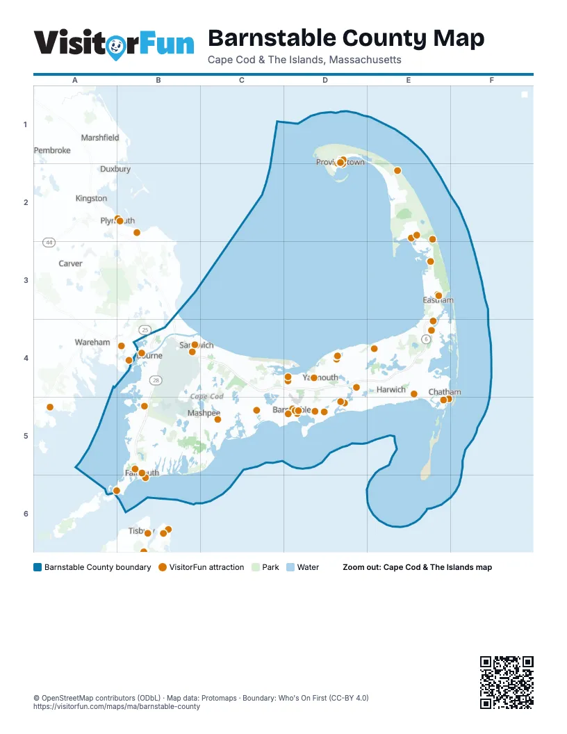
Street index of Barnstable County
Each street on the sheet and the grid squares it crosses.
- Pilgrim HighwayB3, B4
- Mid Cape HighwayB4, C4, D4, E4
- Pilgrims HighwayB4
Things to do on the Barnstable County map
- 3 Dukes Fishing
- Arnold's Lobster & Clam Bar
- Art's Dune Tours
- Bass River Kayaks and Paddle Boards
- Bookstore & Restaurant
- Cahoon Museum of American Art
- Cape Cod
- Cape Cod Canal Region
- Cape Cod Central Railroad
- Cape Cod Lobster Cruises
- Cape Cod Melody Tent
- Cape Cod Museum of Art
- Cape Cod Museum of Natural History
- Cape Cod National Seashore
- Cape Cod Rail Trail
- Cape Escape Adventure Golf
- Cataumet Crossing
- Cee Jay Fishing
- Center for Coastal Studies
- Chatham Lighthouse & Main Street
- Chatham Sport Fishing
- Christmas Joy of Cape Cod
- Coast Guard Heritage Museum
- College Light Opera Company
- Commercial Street, Provincetown
- Dolphin Fleet Whale Watch
- Edward Gorey House
- Fine Arts Work Center
- Helen H Deep Sea Fishing
- Heritage Museums & Gardens
- Highland Light
- Hy-Line Cruises
- Hyannis Main Street
- Hyannis Whale Watcher Cruises
- Jack's Boat Rental
- John F. Kennedy Hyannis Museum
- Orleans Firebirds
- Patriot Party Boats
- Pilgrim Monument & Provincetown Museum
- Pirate's Cove Adventure Golf
- Predatuna Sportfishing
- Provincetown Art Association and Museum (PAAM)
- Provincetown Chamber of Commerce
- Sandwich
- Sandwich Glass Museum
- Schooner Liberté
- Shark Shark Tuna Fishing Charters
- Steamship Authority
- The Cape Playhouse
- The Lobster Pot
- The Wellfleet Beachcomber
- Wellfleet Drive-In Theatre
- Whydah Pirate Museum
Places on the map
- Anna Gordon Moraine Trail
- Ashumet Pond
- Barnstable
- Barnstable County
- Barnstable County Fairgrounds
- Barnstable Marina
- Bass River Golf Course
- Bass River Rod & Gun Club
- Bassett's Island
- Bayberry Hills Golf Course
- Beach Pond
- Bearse Pond
- Beebe Woods
- Bell’s Neck Conservation Lands
- Billingsgate Shoal
- Black Flats Conservation Area
- Boardwalk Beach
- Bourne
- Bourne Water District
- Bourne's Pond
- Breivogel Property
- Brewster
- Bridge Creek Conservation Area
- Cahoon Hollow Beach
- Camp Greenough
- Canal Generating Plant
- Cape Cod
- Cape Cod Aggregates
- Cape Cod Canal Access
- Cape Cod Country Club
- Cape Cod National Golf Club
- Cape Cod National Seashore
- Cape Cod Rail Trail
- Cape Cod Space Force Station
- Captains Golf Course
- Cataumet
- Centerville
- Chapin Beach Conservation Land
- Chase Garden Creek WMA
- Chatham
Maps inside Barnstable County
Next to Barnstable County
- Carver
- Duxbury
- Kingston
- Marshfield
- Mattapoisett
- Oak Bluffs
- Pembroke
- Plymouth
- Tisbury
- Wareham
© OpenStreetMap contributors (ODbL) · Map data: Protomaps · Boundary: Who's On First (CC-BY 4.0)