

Massachusetts map
Mashpee map
About 15,482 people live here (Census Bureau, 2024 estimate). The sheet's index lists 300 streets; Main Street, Falmouth-Sandwich Road and Falmouth Road cross the most grid squares. Also on it: Otis Air National Guard Base, Ashumet Pond and Child's River Cooridoor.
Open the map (PDF, US Letter)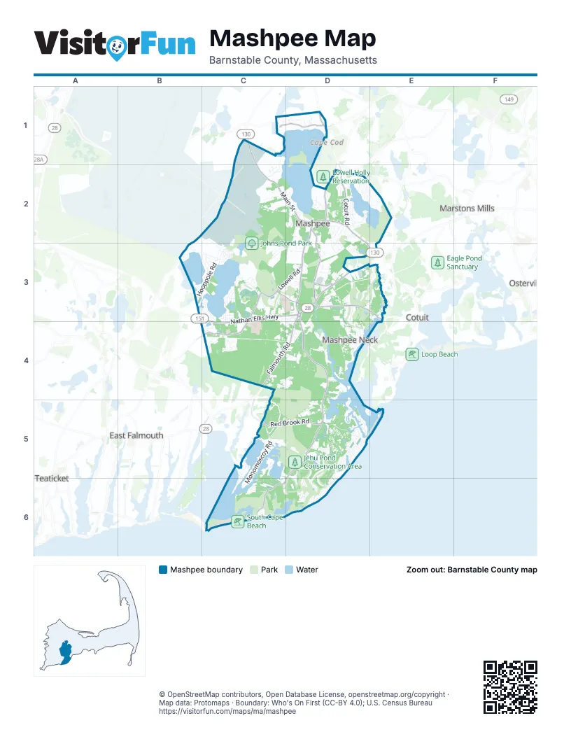
Street index of Mashpee
Each street on the sheet and the grid squares it crosses.
- Main StreetC1, C2, D2, D3, E3
- Falmouth RoadD3, C4, D4
- Nathan Ellis HighwayC3, D3, C4
- Cotuit RoadD1, D2, E3
- Mashpee Rotary CircleD3
- Forestdale RoadC1
- Great Neck Road SouthD3, D4, D5
- Great Oak RoadD5, C6, D6
- Great Neck Road NorthD2, D3
- Red Brook RoadC5, D5
- Quinaquisset AvenueD3, E3
- School Street CotuitE3
- Old Barnstable RoadC3, D3, C4
- Meetinghouse RoadD2, D3
- South Sandwich RoadD2
- Pimlico Pond RoadC1, D1
- Falmouth-Sandwich RoadC1, B2, C2, B3
- Lowell RoadC3, D3
- Ashers Path EastD3
- Sandwich Cotuit RoadD1
- Asa Meiggs RoadD2
- Wakeby RoadD2
- Boardley RoadD1
- Monomoscoy RoadC5, C6
- Mashpee Neck RoadD3, D4
- Shore Drive WestD5, D6
- Wading Place RoadD5
- Lovells LaneD2, D3
- Hooppole RoadB3, C3
- ReillyC2
- Rock Landing RoadD5
- Shore DriveD5, D6
- Surf DriveC5
- Wheeler RoadB3, C3
- Fells Pond RoadD5
- Daniels Island RoadD5
- Great Pines DriveD4
- James CircleB3, C3, C4
- Glenneagle DriveD5, D6
- Sampsons Mill RoadD3, E3
- Quashnet RoadD2, C3, D3
- Pine Hill BoulevardC3
- Polaris DriveC4, D4
- Walton Heath WayD5
- Uncle Percys RoadD5
- Ashumet RoadC2, D2
- Algonquin AvenueC3, C4
- Captains RowD4
- Back RoadC2, C3
- Commercial StreetD4
- Leisure Green DriveC3
- Greensward RoadD5, D6
- WaterwayD5
- Timberlane DriveD2
- Summersea RoadD5
- Noisy Hole RoadD2, D3
- Shellback WayC4, D4
- Popponesset Island RoadD5
- Old Brickyard RoadC3, C4
- Industrial DriveC4, D4
- Scituate RoadD2
- Mid-Iron WayC6, D6
- Snead DriveC3
- West WayD4
- Pond CircleB3
- Eagle DriveD3, D4
- The HeightsD3, D4
- Ninigret AvenueC3, C4
- Simons Narrows RoadD4
- Sunset StripD2, D3
- Dover RoadC4, D4
- Whippoorwill CircleC6
- Willowbend DriveD3
- Dunrobin RoadE3
- Izzea StreetC2
- Sipps RoadD5, C6
- Wampanoag DriveC3
- Blue Spruce WayD4
- Granville AvenueC2
- Simons RoadD3, E3
- Old Colony DriveD2
- Orchard RoadD3
- Tide RunC5, C6
- Sea OaksD3
- Bog River BendC4
- Echo RoadC2
- Palmer RoadC3, D3
- Mashpee Transfer StationD3
- Paddock WayD5
- Shields RoadD2
- Country Club LaneC3
- powerline truck pathD3
- Cross RoadC4, D5
- Bakers RoadC2
- Amos Landing RoadD4
- Meadowbrook RoadC5
- Alice Lopez DriveD3
- Easton RoadC2
- Thornberry CircleC4
- Carleton DriveD3
- Highland StreetC3
- Lakewood DriveD2
- Brewster RoadD3
- Hogan DriveC3, D3
- Bayshore DriveC5
- McGregor's RoadC6
- Edgewater RoadD2
- Troon WayD5, D6
- Grey Hawk DriveC3
- North Glen DriveD3
- Cape DriveD3
- Horseshoe Bend WayB3
- Sheffield PlaceD2
- The Hacking CircleD5
- Stratford RidgeD3
- River RoadD4
- Stratford Ponds RoadD3, E3
- Park Place WayD2
- Pickerel Cove CircleC1, C2
- Cayuga AvenueC3
- Camden LaneD4
- Cobblestone CircleD5
- Saddleback RoadC3, D3
- Yardarm DriveD4
- Wilann RoadD2, D3
- Uncle Edwards RoadD5
- Neshobe RoadC6
- Blue Castle DriveD5
- Degrasse RoadD5
- High Wood WayD5
- Pickerel Cove RoadC1, C2
- Deerfield RoadD1
- Taurus DriveC4, D4
- Lakeview DriveB3
- Seanest DriveD6
- Shoestring Bay RoadD4
- Dry Hollow LaneD4
- Santuit Pond RoadD2, E2
- Shorewood DriveC3
- Bluff AvenueD5
- Sunset CircleC3
- Ruxton CircleC3
- Leather Leaf LaneC4
- Ashumet AvenueC3
- Trout Brook RoadC2
- South Outer RoadC2
- Racquet DriveE2
- Gold Leaf LaneD4
- Ladys Slipper LaneC4
- Mercantile WayD4
- Fairway LaneD5, D6
- Punkhorn Point RoadD4
- Alma RoadD5
- Wintergreen RoadC5, D5
- Lisa LaneD5
- Seconsett Point RoadC5, C6
- Vista CircleD3
- Flat Pond CircleD6
- Josephine BendE2
- Nicolettas WayC2, D2
- Riverview AvenueE3
- Market StreetD3, D4
- The Hunt CircleD5
- Fox Hill RoadD2
- Poppy PlaceD5
- Redwood CircleD2
- Manitoba RoadC6
- Waterline South DriveC5, C6
- Jones RoadD2
- Triton WayD6
- Nehoiden RoadC6
- Reilly StreetC2
- Ryans WayD3
- Regatta DriveD3
- Forest DriveD2
- Portside DriveC3
- Longwood RoadC3
- Beechwood DriveD2
- Payamps RoadC3
- Cottage LaneD5
- Greensward CircleD5, D6
- Buccaneer WayD4
- Deer Ridge RoadD2
- Bayview RoadC5
- Jobs Fishing RoadC3, C4, D4
- Clover LaneD5
- Pond View DriveC4
- Evergreen CircleC2
- Hook DriveD5
- Cranberry AvenueC3
- Seconsett Island RoadC5
- Four Seasons DriveD5
- Birch WayD2
- Gunters LaneD1
- Windsor WayD2
- Municipal water access roadD3
- Steeple StreetC3, D3, D4
- Monahansett RoadD5
- Bowdoin RoadD3
- Jonas DriveD2
- Nick TrailD5
- Gullane RoadD3
- Pleasant Park DriveD3, E3
- Frog Pond CloseD4
- Pinecrest AvenueC3
- Wood RoadD4
- Sewall DriveD3
- Mashie CircleD6
- Amy Brown RoadC5
- Godfrey RoadD4
- Uncle Henrys RoadD5
- Woodland AvenueC3
- Cambridge DriveD2
- Center StreetD2
- Quashnet Woods DriveC4
- Oregon RoadD2
- Treasure LaneD4
- Brassie WayD6
- Spinnaker DriveD4
- Herring Gull RoadD4
- Tobisset StreetD2
- Bayview Condominium RoadC5, D5
- Sakonnet DriveC3
- Southport DriveC3
- Cranberry Ridge RoadD3
- Spoondrift WayD5
- Military serviceC1
- State Landing RoadD2
- Devonshire DriveD2
- Bates RoadD3
- Topping LiftC5, C6
- Preakness LaneC1
- Bearse RoadD5
- Old Dock LaneD4
- Cappawack RoadC3
- Quaker Run RoadD4
- Scenic DriveD2
- Sassacus RoadC3
- Running Light WayD5
- Quail Hollow RoadC3
- Spinnaker Drive WestD4
- Massasoit AvenueC3, C4
- Musket LaneD4
- Pierre Vernier DriveD1
- Surrey PlaceD5
- Beechwood Point DriveD2
- Rock Island RoadD5, D6
- Sandy Fox DriveD2
- Halyard LaneD5
- Dixon DriveC4
- Job's Fishing RoadD4
- Tracy LaneD5
- Kim PathD5
- Fin WayD5
- Donna's LaneD4
- Santuit LaneD2
- Sea View LaneD6
- Bayberry DriveD2, E2
- Pebble Beach AvenueC3
- Riverside RoadC5
- Greenwood RoadD5
- Jackbon RoadD4
- Meadow Haven DriveE2, E3
- Bright Coves WayD5
- Tri-Town CircleB3
- Chavez StreetC2
- Red Cedar RoadD4
- Canonchet AvenueC3
- Player CircleC3, D3
- Radcliffe RoadD2
- Little Neck LaneD5
- Drew LaneD3
- Pequot RoadD2
- Russell RoadC5
- Maple StreetD2
- Emma Oakley Mills WayD2
- Old Brick Yard RoadC3, C4
- Sturgis LaneC2, D2
- Prestwick LaneD5, D6
- Slice WayD5
- Hemlock DriveD2
- Somerset RoadD2
- Leeward LaneD2
- Uncatena RoadD5
- Driftwood CircleC6
- Village Green CircleD3
- Frank E Hicks DriveC3
- Sandy WayC5
- Highview AvenueC3
- County RoadC4
- Fiddler Crab LaneD5
- Lanyard WayD6
- Autumn DriveD2
- Rainbow LaneD3
- Essex RoadD2
- Juniper DriveD2
- Briar Patch LaneD2, E2
- Grant Breen DriveC4
- Ashers Path WestD3
- Nobska RoadD2
Places on the map
- Alper Conservation
- Ashumet Pond
- Bourne Conservation Land
- Camp Farley
- Child's River Cooridoor
- Conservation Land
- Dean Pond
- Flat Pond
- Flat Pond Marshes
- Great River
- Greenswood Greenbelt
- Hamblin Pond
- Jehu Pond
- Jehu Pond Conservation Area
- John Austin Forest
- Johns Pond
- Johns Pond Park
- Lowell Holly Reservation
- Makepeace Sanctuary
- Martha Pond
- Mashpee Commons
- Mashpee Middle-High School
- Mashpee National Wildlife Refuge
- Mashpee Pine Barrens Wildlife Management Area
- Mashpee Pond
- Mashpee River Woodlands
- Mingo Conservation Area
- New Seabury Country Club
- Ockway Bay
- Otis Air National Guard Base
- Popponessett Bay
- Quashnet Valley Golf Course
- Santuit Pond
- Santuit Pond Preserve
- Shoestring Bay
- South Cape Beach
- South Cape Beach State Park
- Wakeby Pond
- Willowbend Country Club
Next to Mashpee
- Cotuit
- East Falmouth
- Marstons Mills
- Osterville
- Teaticket
© OpenStreetMap contributors, Open Database License, openstreetmap.org/copyright · Map data: Protomaps · Boundary: Who's On First (CC-BY 4.0); U.S. Census Bureau















