

Massachusetts map
Provincetown map
A printable two-page map of Provincetown (Barnstable County, Massachusetts), drawn by VisitorFun from OpenStreetMap. Page two is the street index: every street on the sheet with its grid square, the same list as below.
Open the map (PDF, US Letter)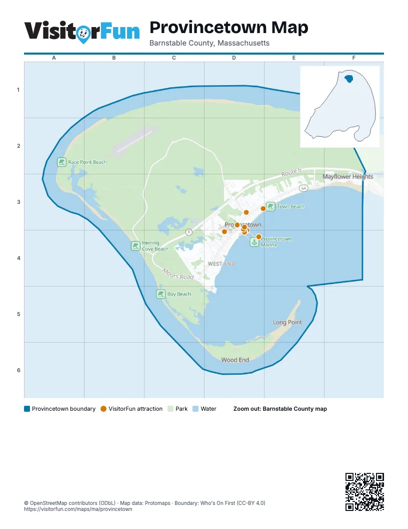
Street index of Provincetown
Each street on the sheet and the grid squares it crosses.
- Coast Guard Station RoadB1, B2
- Race Point RoadB1, C2, D2, D3
- Airport RoadB2, C2
- Province Lands RoadC2, B3, C3, B4, C4, D5
- Province Lands Road BranchC2
- Tin Pan Alley RoadD2
- Route 6E2, C3, D3, C4
- Snail RoadE2, E3
- Mayflower AvenueF2, F3
- Mount Gilboa RoadF2, F3
- Alden StreetD3
- Aunt Sukeys WayD3
- Baker AvenueD3
- Bangs StreetD3
- Bradford StreetD3, E3, C4, D4
- Brewster StreetD3
- Captain Bertie's WayD3
- Cemetery RoadD3
- Center StreetD3
- Conwell StreetD3
- Dyer StreetD3
- Fishburn CourtD3
- Freeman StreetD3
- Georges PathD3
- Harry Kemp WayD3
- Heather's WayD3
- Hensche LaneD3
- High Pole Hill RoadD3
- Holway AvenueD3, D4
- Howland StreetD3, E3
- Jerome Smith RoadD3
- Johnson StreetD3
- Kiley CourtD3
- Law StreetD3
- Lovetts CourtD3
- MacMillan WharfD3, D4
- Maple CourtD3
- Mayflower StreetD3
- Miller Hill RoadD3
- Nelson AvenueD3
- Oak DriveD3
- Off Cemetery RoadD3
- Off Conwell StreetD3
- Old Ann Page WayD3
- Old Colony WayD3
- Pearl StreetD3
- Pearl Street LandingD3
- Priscilla Alden RoadD3
- Province RoadD3
- Rail Road AvenueD3
- Railroad AvenueD3
- Ryder StreetD3, D4
- Ryder Street ExtensionD3, D4
- Sandy Hill LaneD3
- Santos CourtD3
- Seashore Park DriveD3
- Shank Painter RoadD3, D4
- Ships Way RoadD3, C4, D4
- Ships Way Road ExtensionD3
- Smalls CourtD3
- Stable PathD3
- Standish AvenueD3
- Standish StreetD3
- Standish WayD3
- Stearns AvenueD3
- Tinys WayD3
- Transfer Station RoadD3
- Upper Miller Hill RoadD3
- Vorse LaneD3, E3
- Wareham RoadD3
- Washington AvenueD3
- Webster AvenueD3
- Willow DriveD3, E3
- Winslow StreetD3, D4
- Youngs CourtD3
- Allerton StreetE3
- Anthony StreetE3
- Atkins Mayo RoadE3
- Bradford Acres RoadE3
- Cesco LaneE3
- Commercial StreetE3, F3
- Conway StreetE3
- Cook StreetE3
- Duncan LaneE3
- Fortuna RoadE3
- Hancock StreetE3
- Kendall LaneE3
- Snow StreetE3
- Somerset RoadE3
- Thistlemore RoadE3
- Thistlemore WayE3
- Bayview AvenueF3
- Berry LaneF3
- Cleveland StreetF3
- Commodore AvenueF3
- Dewey AvenueF3
- Foss RoadF3
- Garfield StreetF3
- Harbor DriveF3
- Hobson AvenueF3
- Mermaid AvenueF3
- Roosevelt StreetF3
- Schueler BoulevardF3
- Winston AvenueF3
- Winston CourtF3
- Bayberry AvenueC4, D4
- Blueberry AvenueC4, D4
- Bradford Street ExtensionC4, D4
- Creek Hill RoadC4
- Creek Round Hill RoadC4
- Kimberly LaneC4
- Meadow RoadC4, D4
- Pilgrim Heights RoadC4
- Race RoadC4, D4
- Atlantic AvenueD4
- Atwood CourtD4
- Browne StreetD4
- Cape Tip EstatesD4
- Carnes AvenueD4
- Carnes LaneD4
- Carver CourtD4
- Carver StreetD4
- Central StreetD4
- Conant StreetD4
- Cottage StreetD4
- Court StreetD4
- Creek RoadD4
- Cudworth StreetD4
- Fishermen's WharfD4
- Franklin StreetD4
- Fritz's WayD4
- Good Templar PlaceD4
- Gosnold StreetD4
- Kings WayD4
- Mechanic StreetD4
- Methodist ChurchD4
- Montello StreetD4
- Mozart AvenueD4
- Nickerson StreetD4
- Oppen LaneD4
- Pilgrims LandingD4, D5
- Pleasant StreetD4
- Point StreetD4
- Prince StreetD4
- School StreetD4
- Short StreetD4
- Snows LaneD4
- Soper StreetD4
- Spinnaker LaneD4
- Telegraph Hill RoadD4
- Tremont StreetD4
- Watsons CourtD4
- Webster PlaceD4
- West Franklin StreetD4
- West Vine StreetD4
- West Vine Street ExtensionD4
- Whorfs CourtD4
- Winthrop PlaceD4
- Winthrop StreetD4
- Provincetown RotaryD5
Things to do on the Provincetown map
Places on the map
- Airport Road
- Alden Street Lot
- Anchor Inn
- Atlantic White Shark Conservancy
- Aunt Sukeys Way
- AWOL
- B Street Garden Conservation Restriction
- Bayberry Accommodations
- Bennett Pond
- Berta Walker Gallery
- Boy Beach
- Bradford House & Motel
- Bradford Motel
- Breakwater Motel
- Cape Air
- Cape Cod Five
- Cape Codder
- Cape Colony Inn
- Cape Tip Self Storage
- Clapps Pond
- Clapps Pond & Evans Field
- Clapps Pond Access
- Clapps Round Pond
- Coastal Acres Camping Court
- Court Street Landing
- Cumberland Farms
- CVS Pharmacy
- Days Lot
- Del Deo Conservation Restriction
- Downey Parcel
- Duck Pond
- Dunes Edge Campground
- Dwyer Family Woodlands
- East End
- Eastwood at Provincetown
- Fanizzi's Restaurant by the Sea
- Fay's Automotive
- FedEx Ship Center
- Fine Arts Work Center
- Fishermen's Wharf
Maps inside Provincetown
© OpenStreetMap contributors (ODbL) · Map data: Protomaps · Boundary: Who's On First (CC-BY 4.0)