

Massachusetts map
Weymouth map
About 60,159 people live here (Census Bureau, 2024 estimate). The sheet's index lists 300 streets; Washington Street, Pleasant Street and Pilgrim Highway cross the most grid squares. Also on it: Abigail Adams School, Abigail Adams State Park and Academy Avenue School.
Open the map (PDF, US Letter)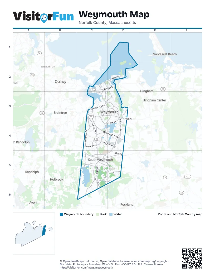
Street index of Weymouth
Each street on the sheet and the grid squares it crosses.
- Pilgrim HighwayC4, D4, D5
- Pilgrims HighwayC4
- Main StreetC4, C5, C6
- Washington StreetC2, C3, C4, D4
- Randolph StreetC5, C6
- Bridge StreetC2, D2
- Lincoln StreetC2, D2
- Anne StreetC6
- Plymouth StreetC6
- Bedford StreetC6
- Commercial StreetC3, D3
- Pleasant StreetD3, D4, C5, D5
- Middle StreetD3, C4, D4
- Broad StreetC3, D3
- Pond StreetC5, C6
- Union StreetC5, D5
- North StreetC2, C3
- Columbian StreetC4, C5
- Ralph Talbot StreetC5, D5
- Green StreetD2, C3, D3
- West StreetC4
- Park AvenueC5, D5
- Forest StreetC5
- Oak StreetD5
- Winter StreetC4
- Liberty StreetD5
- Park Avenue WestC5
- High StreetD3
- Grove StreetD3, C4, D4
- Sharp StreetD5
- Derby StreetC5, D5
- Water StreetD3, D4
- Liberty SquareC4
- Weymouth StreetC5
- Fresh River AvenueD3
- Adams StreetC6
- Whiting StreetD4
- Front StreetC3, C4
- Summer StreetC3, C4
- East StreetC3, D3
- Essex StreetC3, C4
- Shea Memorial DriveC5, D5, D6
- Thicket StreetC5, C6
- Neck StreetD2, C3
- Libbey Industrial ParkwayC4, D4
- Patriot ParkwayC6, D6
- Lake StreetD3, C4, D4
- River StreetD2
- Central StreetC5, D5
- Memorial Grove AvenueC5
- Wessagussett RoadC2
- Sea StreetC2
- Evans StreetC2, C3
- Mutton LaneD4
- Pearl StreetC2, C3
- Academy AvenueC3, D3
- Trotter RoadC5, C6
- Norton StreetC3
- Webb StreetC3
- King AvenueC3, C4
- Snow Bird AvenueC5
- Bill Delahunt ParkwayD6
- Mill StreetC4
- Hollis StreetC5
- Shawmut StreetD3
- Federal StreetC4
- Regatta RoadC2, D2
- Church StreetC3
- Unicorn AvenueD3
- Spring StreetC3
- Ocean AvenueC2
- Market StreetC6
- Pine StreetD4, D5
- Broad ReachD2
- Gaslight DriveC5
- Westminster RoadD4
- Avalon DriveC4
- Tall Oaks DriveC4, D4
- Sheri LaneC6
- Taxiway AC6, D6
- Stonehaven DriveC5
- Liberty Bell CircleD3
- Belmont StreetC4
- Idlewell BoulevardC3
- King Philip StreetC5
- Lake Shore DriveC4, D4
- Parkview StreetC5, C6
- Pierce RoadC3
- White StreetC5
- Century RoadD4, D5
- Jaffrey StreetC3
- Elmer RoadC6
- Great Hill DriveD2
- Sandtrap CircleD5
- Rinaldo RoadC3, D3
- Mediterranean DriveC4
- Lyra DriveD5
- Roosevelt RoadC3
- Bald Eagle RoadC5, D5
- Runway 08/26C6
- Weathervane DriveD5
- Lambert AvenueD4
- Prospect Hill DriveD2
- Heritage LaneC3
- Lakehurst AvenueD4
- Mount Vernon Road EastD3
- Moreland RoadC3, D3
- Springvale CircleC3
- Circuit AvenueC4
- Performance DriveC4, D4
- Pilgrim RoadC2
- Hawthorne StreetD3, D4
- Homestead AvenueC4
- Chard StreetD3
- Colonel's LaneD4
- Southern AvenueC4, C5
- Clinton RoadD3
- Essex Heights DriveC3, C4
- Cedar StreetD3, D4
- Audubon RoadC4
- Susan RoadC6
- Mount Vernon Road WestD3
- Robinswood RoadC5
- Merryknoll RoadD3
- Randall AvenueD3
- Knollwood CircleC4
- Worthen AvenueC4
- Whipple StreetC4
- West Lake DriveC4
- Nevin RoadC5
- Burkhall StreetC4, D4, D5
- Old Stone WayD4
- Hanian DriveD3
- Lane AvenueC4, D4
- Holly Hill CircleD5
- Fort Point RoadD2
- Charles StreetD3, D4
- Phillips StreetC3
- Lorraine StreetD4
- Rockway AvenueC4
- Rindge StreetC3
- Iron Hill StreetD3, D4
- Torrey StreetC5
- Queen Anne DriveD4
- Thompson RoadC3, D3
- Wildcat WayC5
- Charles Diersch StreetD4
- Birchbrow AvenueC2
- Prospect StreetC3
- Babcock AvenueC2
- Sunny Plain AvenueC4
- Donnellan CircleC3, D3
- Puritan RoadD3
- Weyham RoadD2
- Endicott StreetD3
- Lintric DriveD5
- Great Republic AvenueC5, D5
- Finnell DriveC4
- Cornish StreetC3, D3
- Ralston RoadC5, D5
- Greenvale AvenueC4
- Rockcroft RoadC4, C5
- Ivy RoadC5
- Circuit RoadD4, D5
- Fuller RoadD2
- Morningside PathD4
- Putnam StreetD3
- Fieldstone LaneC3, C4
- Candia StreetC3
- Hickory LaneD5
- Standish StreetC2, C3
- Lester LaneC4
- Gilbert RoadC3, D3
- Constitution AvenueD5
- Grant StreetD3
- Carolyn RoadC4, C5
- Memorial DriveD4
- Flint Locke DriveD3
- Hibiscus AvenueC3
- Windsor RoadC4
- Old Country WayC3
- Moore RoadD4
- Queen Anne CourtD4
- Doris DriveD3
- Tower AvenueC5
- Hill StreetD3
- Mason StreetC5
- Seminole AvenueC3
- Wilson AvenueC3
- Hinston RoadD3
- Lovell StreetC2, D2
- Ellis CircleD5
- Tamarack TrailD5
- Pleasantview AvenueC3
- Abigail Adams CircleC3
- Ryder RoadC4
- Keith StreetC3
- Wingate RoadD3
- Tilden RoadD5
- Judith RoadD3
- Oak Ridge CircleC3
- Woodrock RoadD4
- Saint Margaret StreetC4, D4
- Swan AvenueC5
- Madison StreetD3
- Meredith WayC3
- Brae RoadD2
- Mansfield StreetD5
- Apple Tree LaneC4
- Mercury StreetC4, C5
- Richmond StreetC3
- May TerraceC5, D5
- Old Colony DriveC4
- Progress StreetC4
- Aster CircleC4
- Weaver RoadD4
- Clarendon StreetC5
- Whitman StreetD3
- Patricia LaneC6
- Cherry LaneD5
- Groveland AvenueD5
- Lakewood RoadC5
- Bluff RoadC2, C3
- Sunrise DriveD3
- Vine StreetC3
- Beals StreetC3
- Harding AvenueC3
- Judson RoadC4
- King's Cove Beach RoadC2
- Branch RoadD5
- Clematis AvenueC3
- Norma AvenueC4
- Jordan DriveD5
- Edward Cody LaneD5
- Fountain LaneC5
- Shaw StreetC2, D2
- Squanto RoadC2
- Sutton StreetC3
- Pecksuot RoadC2
- Gale RoadC3
- Samoset StreetC5
- Barnes AvenueD5
- Biscayne AvenueC3
- Blackstone RoadC2
- Perry StreetD4
- Seaver RoadD4
- Kingman StreetC3, C4
- Wharf StreetD3
- Wampum StreetC5
- Colonial RoadC3
- Blanchard RoadC5
- Mill River DriveC4
- Coolidge AvenueC3
- Rosemary LaneD4
- Colasanti RoadC3, D3
- Colonel's DriveD4
- Healy RoadC4
- Western AvenueC4
- Priscilla CircleC3
- Bradley RoadC2, D2
- Joseph A Fern CourtD4
- Elva RoadD3
- Wituwamat RoadC2
- Alroy RoadC5
- Nash RoadC4
- School House RoadC3
- Lindale AvenueD2
- Raymond StreetD4
- Barbara LaneC5
- Kensington RoadC3
- Longwood RoadC3
- Cummings RoadD5, D6
- Glendening TerraceC5, D5
- Rustic DriveD5
- Granite StreetC3
- Saning RoadC3
- Harrington CircleC3
- Overlook RoadD4
- Cain AvenueD3
- Hillcrest RoadD3
- Burton TerraceC5
- Union Point Trail NetworkC5
- Cynthia CircleC4
- Durant RoadC5
- Katherine StreetD3
- Holmes AvenueD3
- Epping StreetC3
- Leahaven RoadD5
- Mandalay RoadD5
- Newbert AvenueC5
- Center StreetD3
- Cottage LaneC4
- Winter CourtC4
- Fisher RoadC5
- Parnell StreetD2
- Summit StreetC3
- Adams PlaceC5
- Taft RoadC3
- Kirkland RoadC5
- Keating CircleC5
Places on the map
- Abigail Adams School
- Abigail Adams State Park
- Academy Avenue School
- Allerton House Assisted Living
- Arbor Hill Conservation
- BJ's Wholesale Club
- Boston Harbor Islands National Recreation Area
- Bradford Hawes Park
- Bradford Torrey Bird Sanctuary
- Cadman Conservation Area
- Cavern Rock Park
- Cranberry Pond
- Creek Trail Park
- George Lane Beach
- Grape Island
- Great Esker Park
- Great Pond Nature Preserve
- House Rock Park
- J. F. Price Co. and Bates Bros. Granite Co.
- King Oak Hill Park
- Legion Memorial Field
- Millstone Conservation Area
- North Weymouth
- Old Swamp River Conservation
- Osprey Overlook Park
- Pratts Meadow
- Ralph Talbot Nature Reserve
- Ralph Talbot School
- Riverway Plaza
- South Shore Hospital
- Southern Wessagusset Woods
- Union Point Sports Complex
- Weathervane Golf Club
- Webb Memorial State Park
- Wessagusset Woods
- Weymouth Fore River Marshes
- Weymouth Great Pond
- Weymouth High School
- Weymouth Woods
- Whitmans Pond
Next to Weymouth
- Avon
- Braintree
- Hingham
- Hingham Center
- Holbrook
- Milton
- Nantasket Beach
- North Randolph
- Quincy map
- Randolph
- Rockland
- Wollaston
© OpenStreetMap contributors, Open Database License, openstreetmap.org/copyright · Map data: Protomaps · Boundary: Who's On First (CC-BY 4.0); U.S. Census Bureau