

Massachusetts map
Greater Boston map
The sheet's index lists 32 highways; US 1, I-95 and I-495 cross the most grid squares. Things to do inside the boundary: Adams National Historical Park, Arnold Arboretum and Bass Pro Shops. Also on it: Avon, Bellingham and Boston.
Open the map (PDF, US Letter)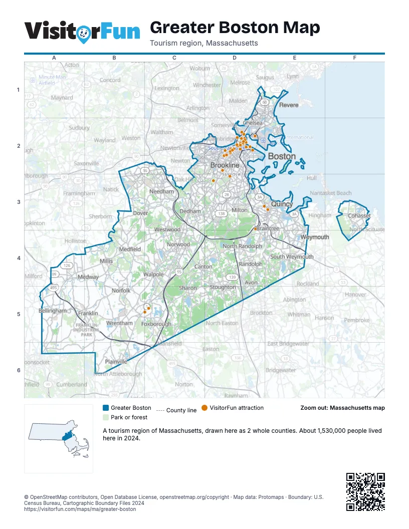
Highway index of Greater Boston
Each highway on the sheet and the grid squares it crosses.
- I-90C2, D2
- I-93C4, D2, D3, D4
- I-95C2, C3, C4, C5, C6, D4
- I-495A4, A5, B5, B6, C6
- US 1B5, C3, C4, C5, D1, D2, D3, D4
- US 3D2
- US 20C2, D2
- MA 1AD2, E1, E2
- MA 2D2
- MA 2AD2
- MA 3D2, D3, E3, E4
- MA 3AD3, E3, F3
- MA 9B2, B3, C2, D2
- MA 16B2, B3, C2, D1, E1
- MA 18E4
- MA 24D4
- MA 27B4, C4, C5, D4, D5
- MA 28D2, D3, D4, D5
- MA 30C2, D2
- MA 37D3, D4, D5, E4, E5
- MA 53E3, E4
- MA 60D1, E1
- MA 99D2
- MA 107D1, E1
- MA 109A4, B4, C3, C4
- MA 126A4, A5, A6
- MA 128C2, C3, C4
- MA 135B3, C3
- MA 138D3, D4, D5
- MA 139D4, D5, E4
- MA 140A5, B5, C5, C6
- MA 203D2, D3
Things to do on the Greater Boston map
- Adams National Historical Park
- Arnold Arboretum
- Bass Pro Shops
- Boston Children's Museum
- Boston Common Visitor Center
- Boston Duck Tours
- Boston Public Garden & Swan Boats
- Boston Public Library, Central Library in Copley Square
- Boston Tea Party Ships & Museum
- Bunker Hill Monument
- Cheers Beacon Hill
- CityView Trolley Tours
- DoubleTree by Hilton Hotel Boston - Downtown
- Embassy Suites by Hilton Boston at Logan Airport
- Faneuil Hall Marketplace & Quincy Market
- Fenway Park Tours
- Franklin Park Zoo
- Ghosts & Gravestones Tour
- Gillette Stadium
- Granary Burying Ground
- Hyatt Place Boston/Braintree
- Hyatt Place Boston/Seaport District
- Institute of Contemporary Art / Boston (ICA)
- Isabella Stewart Gardner Museum
- Massachusetts State House
- Museum of Fine Arts, Boston
- Museum of Science
- New England Trips
- Newbury Street
- Old North Church & Historic Site
- Old South Meeting House
- Old State House
- Old Town Trolley Tours of Boston
- Paul Revere House
- Prudential Center
- Revolutionary Spaces
- Samuel Adams Boston Brewery
- Symphony Hall
- TD Garden
- The Freedom Trail
- The Mother Church
- The Sports Museum
- Tour of the Freedom Trail
- Union Oyster House
- USS Constitution & USS Constitution Museum
- View Boston
Places on the map
- Avon
- Bellingham
- Boston
- Braintree
- Brookline
- Canton
- Chelsea
- Cohasset
- Dedham
- Dover
- Foxborough
- Franklin
- Medfield
- Medway
- Millis
- Milton
- Needham
- Norfolk
- North Randolph
- Norwood
- Plainville
- Quincy
- Randolph
- Revere
- Sharon
- South Weymouth
- Stoughton
- Walpole
- Westwood
- Weymouth
- Wrentham
Next to Greater Boston
- Central Massachusetts
- North of Boston map
- South of Boston map
- Blackstone Valley
© OpenStreetMap contributors, Open Database License, openstreetmap.org/copyright · Map data: Protomaps · Boundary: U.S. Census Bureau, Cartographic Boundary Files 2024