

Maryland map
Allegany County map
About 67,097 people live here (Census Bureau, 2024 estimate). The sheet's index lists 300 streets; National Freeway, National Pike and McMullen Highway Southwest cross the most grid squares. Things to do inside the boundary: Allegany Museum and Great Allegheny Passage.
Open the map (PDF, US Letter)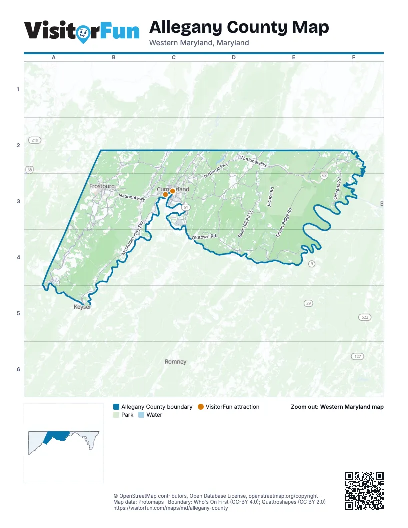
Maps inside Allegany County
1 map inside, from the street map of Allegany County down.
Street index of Allegany County
Each street on the sheet and the grid squares it crosses.
- National FreewayD2, E2, F2, B3, C3, D3, E3, F3
- Maryland AvenueB3, C3, A4
- National PikeD2, E2, F2, B3, C3, D3, E3
- Oldtown RoadC3, C4, D4, E4
- McMullen Highway SouthwestB3, C3, B4, A5, B5
- National HighwayB3, C3
- Mount Savage RoadB2, C2, B3, C3
- McMullen HighwayC3
- Westernport Road SouthwestA5
- Braddock RoadB3, C3
- Winchester RoadB3, B4
- Industrial BoulevardC3
- National Highway SouthwestB3
- Canal ParkwayC3
- Winchester Road SouthwestB3, B4
- Barrelville Road NorthwestB2
- Church StreetB3, C3, A4, B4, A5
- Pratt StreetA4, A5
- East Main StreetB3, A4
- West Main StreetB3, A4
- Vocke Road SouthwestB3, C3
- Front StreetC3, A4
- Henderson AvenueC3
- Queen City DriveC3
- Baltimore AvenueC3
- East Industrial BoulevardC3
- Crooks Avenue SouthwestA5
- Dehaven Road NortheastC2, C3
- West Industrial BoulevardC3
- Ali Ghan RoadC3
- Howard StreetB3, C3, A4
- Willowbrook RoadC3
- South Mechanic StreetC3
- South Centre StreetC3
- Baltimore StreetC3
- Chesapeake Avenue SouthwestA5
- Campground RoadB3, C3
- Queens Point Road SouthwestA5, B5
- Thomas StreetC3
- Winston StreetC3
- Wineow StreetC3
- Paxton StreetA5
- North Front StreetC3
- New Georges Creek Road SouthwestB3, A4
- Williams Road SoutheastC3, D3
- Orleans RoadF2, F3
- Mount Savage Road NorthwestB2, B3
- Upper Georges Creek Road SouthwestB3
- Lower Georges Creek Road SouthwestB3, A4, B4
- Valley Road NortheastC2, C3
- Bedford Road NortheastC2, C3
- High Germany RoadF2, F3
- New Georges Creek RoadB3, A4
- Bedford StreetC3
- Vale Summit Road SouthwestB3
- Frederick StreetC3
- Ellerslie RoadC2
- Black Valley RoadD2, E2
- Christie Road NortheastC3
- Greene StreetC3
- Main StreetB3, A4
- North Orleans RoadF2
- Opessa StreetD4
- Willowbrook Road SoutheastC3
- Valley StreetC3
- Williams StreetC3
- Park StreetB3, C3, A4
- Green StreetB3, A4
- Walnut StreetB3, C3, A4
- North Mechanic StreetC3
- North Centre StreetC3
- Messick Road SoutheastC3
- Flintstone Drive NortheastD2
- Naves Cross Road NortheastC3
- Patriot Parkway SouthwestB4
- Hill Top DriveC3
- Louisiana AvenueC3
- Valley RoadC2, C3
- South Grant StreetB3
- Davidson StreetB3, C3
- Sunset Orchard RoadD2
- Green Spring Road SoutheastD4
- Warrior Drive SouthwestB3, C3
- Bridge StreetC3, A4
- West Harrison StreetC3
- North Water StreetB3
- Oldtown Cemetery RoadD4
- Oldtown Low-Water Toll BridgeD4
- Georges Creek RoadA4
- South Black Valley RoadE2
- South Clear Ridge RoadF2
- Hyndman RoadC2
- Green Ridge RoadE2, E3, E4
- Oliver Beltz Road SoutheastD3
- Bear Hill Road SoutheastD3, D4
- Cresap Mill Road SoutheastD3, D4
- Old Legislative Road SouthwestB3
- Murleys Branch RoadD2, D3
- Breakneck Road NortheastD2, D3
- Mason Road NortheastC2, C3
- Old Williams Road SoutheastC3, D3
- Town Creek Road NortheastD2, D3
- Old Oldtown Road SoutheastC4, D4
- Rocky Gap Road NortheastC2, D2
- Gilpin RoadD2, E2
- Cash Valley Road NorthwestC2, C3
- Pleasant Valley RoadD2
- Uhl Highway SoutheastC3
- Stoney Run Road SouthwestA4
- Mann RoadF2
- Parkersburg Road NorthwestB3
- Flintstone Creek Road NortheastD2
- Christie Road SoutheastC3
- Town Creek Road SoutheastD3
- Town Creek RoadD2, D3
- West Flintstone Creek Road NortheastD2
- Mexico Farm Road SoutheastC3
- Turkey Farm RoadF2
- M.V. Smith Road NortheastE2, E3
- Hinkle Road SoutheastD3
- East Oldtown RoadC3
- Douglas Hill AvenueA3, A4
- Hinkle Road NortheastD3
- Fayette StreetC3
- Pittsburgh Plate Glass Road SoutheastC3
- Mill Run RoadA4
- Cabin Run Road SouthwestB3
- Piney Mountain RoadB3
- Klondike Road SouthwestB3
- Virginia AvenueC3
- M.V. Smith RoadE3
- Street Road NortheastD2
- Seton DriveC3
- Kelly RoadC3
- Country Club Road NortheastC3
- Stoney Run RoadA4
- Old National Pike SouthwestB3
- Shaft Road SouthwestB3
- Bealls Mill Road NortheastC2
- Kreighbaum RoadC2
- New School Road NorthwestB2
- Rock Street SouthwestA4
- Horse Rock Road SouthwestA4, A5
- Legislative Road SouthwestA4
- Braddock StreetB3, C3
- Hazen Road NortheastC2
- Smouse's Mill Road NortheastC2
- Cash Valley RoadC3
- Creek Side Drive SouthwestA4
- Center StreetB3, C3, A4
- Jeffries RoadC3
- Rockville Street SouthwestA4
- Lower Georges Creek RoadA4
- Bottle Run Road NortheastD2
- Cumberland StreetC3
- Paradise Street SouthwestB3
- Philos AvenueA4
- Jeffries Road NortheastC3
- Bowery StreetB3
- Park AvenueB3, C3
- Pinto RoadB4
- Country Club Road SoutheastC3
- Rannells Road NortheastC3
- Welsh Hill Road SouthwestB3
- Hillcrest DriveC3
- Burbridge Road SoutheastC3
- Gephart DriveC3
- Old Mount Savage RoadC3
- West Wilson RoadD2
- Watercliff StreetA4
- Douglas AvenueC3, A4
- South Central AvenueC3
- Beall StreetB3, C3
- Long DriveC3
- West Florida WayA4
- Linden StreetB3, C3
- Squirrel Neck Run RoadB3
- Blue Valley Road SoutheastC3
- Skids Hill RoadA3
- Rock StreetA4
- Pine Ridge Road NortheastC2
- West Elder StreetC3
- Old Coney Cemetery Road SouthwestB3, B4
- Tilghman StreetC3
- East Florida WayA4
- North Lee StreetC3
- South Lee StreetC3
- Old Cresaptown Road SouthwestB3
- Decatur StreetC3
- Union StreetB3, A4
- River AvenueC3
- South Johnson StreetC3
- Cecelia StreetC3
- Parkersburg Road SouthwestB3
- Scenic Drive NortheastC3
- Fletcher DriveC3
- Lamont StreetC3
- Rocky Gap RoadD2
- East Harrison StreetC3
- Victory Post DriveA4
- Westernport RoadA4
- Avilton Lonaconing RoadA3
- Fusner StreetA4
- Old Legislative RoadB3
- Dakota StreetC3
- McFarland RoadF2
- Hazen DriveC2
- Artemas RoadE2
- Mertens AvenueE3
- Oldtown Orleans RoadE3, F3, E4
- Jacobs RoadE3
- Lower Town Creek Road SoutheastD3, E3, D4, E4
- Brice Hollow Road SoutheastC3, D3, C4
- Wagner RoadD3, D4
- Old Williams Road NortheastD3, E3
- Moores Hollow Road SoutheastC3
- Old Cumberland Road NortheastE2
- Kasecamp RoadE3, F3
- East Wilson Road SoutheastD4
- Martins Mountain Lane SoutheastC3, D3, C4
- Mountain RoadE2, E3, F3
- Dughill RoadE3
- Gorman RoadE4
- Buskirk Hollow Road SouthwestB3, B4
- Dailey RoadE4
- Ruby Road SoutheastD3, D4
- Jackson Mountain Road SouthwestA4
- Fifteen Mile Creek RoadE3
- Fifteen Mile Creek Road SoutheastE2
- Malcolm RoadE4
- Laurelhurst BoulevardB4
- Old Dans Rock Road SouthwestB3, B4
- Mile Lane NorthwestB2
- Double Pine RoadE2
- Burning Mines Road SouthwestB3
- West Shipley RoadF2
- Barney Engle Road NorthwestB2, C2
- Walnut Ridge Road SoutheastD3, D4
- Big Ridge RoadE2, E3
- Wallizer RoadE3
- Old Miller Road SouthwestA4
- Pack Horse RoadD4, E4
- Troutman RoadE2, E3
- West Wilson Road NortheastD2, D3
- Dry Ridge Road NortheastD2, E2
- Price RoadF2, F3
- Old MacDonald RoadB3
- Old Braddock TrailD4
- Old Hancock Road NortheastC2, D2
- Blank RoadB2
- Laurel Run Road SouthwestA4
- Divide Ridge RoadF2
- Frog Hollow Road SoutheastD3, D4
- David Thomas RoadE4
- Zeigler RoadF3
- Old Toms Hill Road SoutheastD2, D3
- Washington StreetB3, C3, A4
- Water Station Run Road SouthwestA4, B4
- Hoop Pole RoadF2, F3
- Frank Davis RoadE2, E3
- Brant Road SouthwestB3
- Hoffman Hollow Road SouthwestB3
- Treasure RoadE2
- Cesnick Farm RoadA3, B3
- Keifer RoadE4
- Wagner Cutoff Road SoutheastD3, D4
- Old Mount Pleasant Road NortheastC2, C3
- 21st Bridge Road SouthwestA5, B5
- Seldom Seen Road SouthwestA4
- Yonkers Bottom RoadF3
- Country Club Mall RoadB3
- Stotlemeyer RoadF3
- Shades LaneC3
- Cemetery RoadB3, A4
- Dickerson Hollow Road NortheastD2
- Cliff RoadF3
- Maniford RoadE4
- Wildcat Hollow Road SoutheastC3
- Bishop Walsh RoadC3
- Collier Run Road SoutheastC3, C4
- Harwood Drive SouthwestB3
- Crossover RoadE2
- Carlos Road SouthwestB3
- Warrior Mountain Cutoff Road SoutheastD3
- Old Beechwood Road SouthwestA3, A4
- Mountain Road NortheastE2
- Hill Top Farm RoadD3
- River Road SoutheastC3
- Swain RoadF2
- Root Road NortheastD2
- Sampson Rock RoadB2
- Shellhorn DriveD4
- Potomac Hollow Road SouthwestA4
- Swain Hollow RoadF2, F3
- Outdoor Club RoadE3, E4
- McKenzie Tower RoadB4, C4
- Fairview Road SoutheastC3, D3
- Bald Knob RoadB2
- Teter Hill Road SoutheastD4
- Old Adams RoadF2
Things to do on the Allegany County map
Places on the map
- Barton
- Bedrock Quarry
- Bel Air
- Bier
- Bowling Green
- Bowmans Addition
- Carlos
- Chesapeake and Ohio Canal
- Clarysville
- Constitution Park
- Corriganville
- County Fairgrounds
- Cranberry Swamp
- Cresaptown
- Cumberland
- Cumberland Country Club
- Dans Mountain State Park
- Dans Mountain Wildlife Management Area
- Danville
- Dawson
- Detmold
- Eckhart Mines
- Ellerslie
- Flintstone
- Franklin
- Frostburg
- Georges Creek
- Gilmore
- Grahamtown
- Green Ridge State Forest
- Hillcrest Burial Park
- Hoffman Park
- Kasecamp Road
- Klondike
- La Vale
- Lake Habeeb
- Lavale District Park
- Little Orleans
- Rocky Gap State Park
- Warrior Mountain Wildlife Management Area
Next to Allegany County
- Keyser
- Romney
© OpenStreetMap contributors, Open Database License, openstreetmap.org/copyright · Map data: Protomaps · Boundary: Who's On First (CC-BY 4.0); Quattroshapes (CC BY 2.0)















