

Maryland map
Cumberland map
About 18,643 people live here (Census Bureau, 2024 estimate). The sheet's index lists 300 streets; National Freeway, Industrial Boulevard and Bedford Street cross the most grid squares. Things to do inside the boundary: Allegany Museum and Great Allegheny Passage.
Open the map (PDF, US Letter)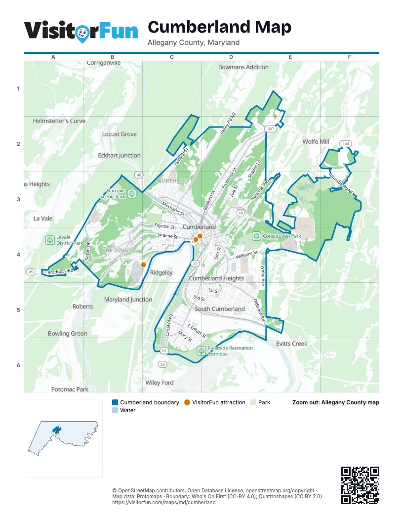
Street index of Cumberland
Each street on the sheet and the grid squares it crosses.
- National FreewayD3, E3, A4, B4, C4, D4
- Maryland AvenueD4
- Industrial BoulevardC4, D4, C5, D5, E5
- Canal ParkwayC4, C5, C6
- Henderson AvenueC3, D3
- Queen City DriveC3, D3, D4
- McMullen HighwayB4
- Baltimore AvenueD3, D4
- East Industrial BoulevardC5, D5
- West Industrial BoulevardC5, D5
- Willowbrook RoadD3, E4
- South Mechanic StreetC4, D4
- South Centre StreetD4
- Baltimore StreetD3, C4, D4
- National HighwayC3
- Thomas StreetC4
- Winston StreetD4
- Wineow StreetD4
- Howard StreetC4, D4
- Front StreetD3, D4
- North Front StreetD3
- Bedford StreetD2, E2, C3, D3, C4
- Frederick StreetD2, E2, C3, D3, C4
- Braddock RoadA4, B4
- Greene StreetB4, C4
- Valley StreetC2, D2, C3
- Williams StreetD4, E4
- North Mechanic StreetC3, C4
- North Centre StreetC3, C4, D4
- Willowbrook Road SoutheastD3, E3, E4
- Hill Top DriveD4, D5
- Louisiana AvenueD4, D5
- Park StreetD4
- Valley RoadD2
- Valley Road NortheastD2
- Bedford Road NortheastE1, E2
- West Harrison StreetC4, D4
- Naves Cross Road NortheastE2
- Bridge StreetC4
- East Oldtown RoadD4, D5, E5
- Fayette StreetB3, C3, B4, C4
- Virginia AvenueD4, C5, C6
- Seton DriveB3, B4
- Kelly RoadB4, C4, B5
- Cumberland StreetC3, C4
- Christie Road NortheastF3
- Gephart DriveB4, C4
- South Central AvenueD3, D4
- Country Club Road SoutheastE3
- West Elder StreetC5
- Beall StreetC4
- Tilghman StreetC3
- North Lee StreetC3, C4
- South Lee StreetC4
- Decatur StreetD3
- River AvenueC5
- South Johnson StreetC4
- Cecelia StreetD4
- Fletcher DriveB4
- Lamont StreetC4, D4
- Country Club Road NortheastE3, F3
- Linden StreetD3
- East Harrison StreetD4
- Bishop Walsh RoadB3, A4, B4
- Shades LaneD2, D3
- Washington StreetB4, C4
- East 1st StreetC5, D5
- Holland StreetC2, C3
- Winifred RoadD4, D5
- Memorial AvenueD4, D5
- Patterson AvenueB4, C4
- Alley 136D5
- Alley 160C6
- Furnace StreetC2, C3
- East 4th StreetC5, D5
- Old Willow Brook Road SoutheastE3, E4
- Alley 66D2
- Leiper StreetD3
- Grand AvenueD4, C5, D5
- Franklin StreetC3
- Pine AvenueD3, D4
- White AvenueD4, E4, E5
- Wempe DriveD5
- Piedmont AvenueC2, C3
- South StreetD5
- East 2nd StreetC5, D5
- Road 1D4, E4
- Pennsylvania AvenueD5
- Wills Creek AvenueB3, C3
- Alley 137D5
- Blackiston AvenueD5
- East Offutt StreetC5, D5, D6
- Yale StreetD3
- Columbia AvenueC3
- Independence StreetC3, D3
- New Hampshire AvenueD5
- Alley 165C5
- Utah AvenueD5
- Lafayette AvenueC5
- Columbia StreetC3, D3
- Alley 156C5, D6
- Race StreetD5
- Alley 138C5, D5
- Alley 164C5
- Elder StreetC5, D6
- Massachusetts AvenueD5
- Avondale AvenueD4
- Parkview AvenueD4
- Arch StreetC5, D5
- Alley 157C5, D6
- Alley 139C5, D5
- Hunt TerraceB4, C4
- Golden LaneD3, E3
- Michigan AvenueD5
- Seymour StreetD5
- Humbird StreetC5, D6
- Greenway AvenueD4
- Alley 126D5
- Alley 140C5, D5
- Alley 159C5, C6
- Alley 158C5, C6
- Waverly TerraceD3
- Camden AvenueB4
- Alley 121D5
- Princeton StreetD3
- Somerville AvenueD5
- Kent AvenueD4
- East Mary StreetC5, C6
- Dorn AvenueD4
- Shriver AvenueC3
- Cherrywood AvenueA4
- Maple StreetD5
- Fort AvenueD3, D4
- Kentucky AvenueD4, D5
- Buckingham RoadB4
- Brown AvenueB4
- Alley 144C5, D5
- Haddon AvenueD4
- Candoc LaneC6, D6
- Nemacolin AvenueA4, B4
- Ella AvenueC5, C6
- Willison PlaceD4
- Church StreetD5
- East Potomac StreetC5, C6
- Avirett AvenueC4
- Alley 130D5
- Alley 127D5
- Sedgwick StreetC3
- Fairmont AvenueC4
- Hawthorne AvenueD4
- Longwood AvenueA4, B4
- Olive AvenueC5, C6
- Springdale StreetC5
- Oak StreetC4, C5
- Gleason StreetD5
- Bond StreetC3
- Brookfield AvenueD4, D5
- Alley 110D4
- South Allegany StreetC4
- Alley 63D2, D3
- Miller AvenueD2
- Woodlawn TerraceD3
- Alley 162C5, C6
- Lexington AvenueC5
- Alley 163C5, C6
- Davidson StreetD3
- Willow Woods CourtE3
- Windsor RoadB4
- Durham DriveD1, D2
- Richwood AvenueA4, B4
- Pear StreetC3
- Alley 104D4
- Friends DriveC2
- Alley 58D3
- Alley 65D2, D3
- Fairview AvenueC3
- Elm StreetD4
- Alley 207B4
- South Chase StreetC4
- East 3rd StreetC5, D5
- White Oaks AvenueD5
- Dale AvenueB4, C4
- Ridgewood AvenueD4
- Prince George StreetD4
- Mount Royal AvenueB4
- Alley 60D3
- Leslie LaneE4
- Paca StreetC4
- Alley 145C5
- Alley 161D5, C6
- Ridge TerraceB4, C4
- Alley 87D4
- Thompson AvenueB4, C4
- Grant StreetD5
- Polk StreetC3, D3
- East Roberts StreetC6
- Mullen StreetD5
- Alley 119D5
- Wellington LaneD2, E2
- Baker StreetD4
- Elizabeth StreetC5
- Essex PlaceC3
- Cleveland AvenueB4, C4
- Arrowhead TrailB4
- Auburn AvenueD4
- Alley 114D4, D5
- Moccasin PathB4
- Montgomery AvenueD4
- Adams AvenueB4, C4
- Caroline StreetD4
- Sperry TerraceB4
- Woodside AvenueD4
- South Wineow StreetC4, D4
- Gulf Memorial DriveD4
- Binstock AvenueD4
- Alley 209B4
- Oakwood StreetD2, D3
- Goethe StreetD3
- High Bedford StreetD3
- Alley 75D3
- Fisher CourtE4
- Alley 4C3
- Alley 115D4, D5
- West Offut StreetC5
- Alley 2C3
- South TerraceB4
- Spruce PlaceC4
- Alley 116D4, D5
- Sylvan AvenueC3
- West 1st StreetC5
- West 2nd StreetC5
- Arnett TerraceC4
- East Clement StreetC6
- Prospect SquareC4
- Woodrigde LaneF3
- Ford AvenueC5, C6
- Alley 101D4
- Alley 117D4
- Lincoln StreetD3
- Fort Hill AvenueD4
- Beechwood DriveD5
- Reservoir AvenueD4
- Alley 102D4
- Eastern AvenueD3
- Springfield BoulevardB4, C4
- West 3rd StreetC5
- Commerce DriveE1, E2
- Rose Hill AvenueC4
- South Paw Paw WayC4
- Alley 105D4
- Magruder StreetC3
- Marion StreetD3
- South Walnut PlaceC4
- Alley 111D4, D5
- Arundel StreetD4, D5
- Pulaski StreetC3
- Quebec AvenueD5
- Alley 71D3
- West Oldtown RoadC4
- Windsor Hills Prairie RoadE3
- Homer StreetD5
- Bowen StreetC5
- Growden TerraceB3, B4
- James Day DriveD3
- Alley 1C3
- Commercial PlaceD5, E5
- Forster AvenueD2
- Edgevale AvenueD4, D5
- Alley 78D3
- Wills Mountain RoadC3
- Alley 106D4
- Alley 3C3
- Cole StreetD3
- Cromwell TerraceD4
- West Mary StreetC5
- Alley 148C5
- Harding AvenueD3
- Alley 128D5
- Shawnee AvenueC3
- Welton DriveD3
- Glenwood StreetC4, D4
- Weber StreetD3
- Gay StreetC4, D4
- North Central AvenueD3
- City View TerraceD4
- Alley 124C4, D4
- Eastgate CourtB4
- Frazier Lake RoadE5
- Walnut StreetC3
- Boone StreetC5
- Queen StreetC5
- Browning StreetC4, C5
- Hill StreetD3
- South George StreetD4
- Alley 24C3
- Rosewood StreetD2
- Broadway StreetD4
- Schley StreetC3
- Alley 33C3
- Byrd AvenueD4
Things to do on the Cumberland map
Places on the map
- Ace Hardware
- Allegany College of Maryland
- Allegany County Courthouse
- Allegany High School
- Allegany Highschool football field
- AutoZone
- B'er Chayim Temple
- Bishop Walsh Catholic School
- Bob Kirk Arena
- Braddock Middle School
- C. William Gilchrist Gallery and Museum
- C&O Canal Towpath
- Canal Place Historical Park
- Chapel Hill Temple Church
- Charis Winery & Distillery
- Children's Medical Group
- Christ United Methodist
- Church of God
- Circle K
- Commons at Cumberland
- Constitution Park
- Constitution Park Ampitheater
- Cumberland Baseball Feild
- Cumberland City Hall
- Cumberland Community Center
- Cumberland Country Club
- Cumberland Healthcare Center
- Cumberland Post Office
- Fort Hill High School
- Greenway Avenue Stadium
- Hillcrest River Kampground
- Love's Travel Stop
- Narrows Scenic Park
- Riverside Recreation Complex
- Road 1
- Rose Hill Cemetery
- Saints Peter and Paul Cemetery
- The UPS Store
- Washington Middle School
- Western Maryland Regional Medical Center
Next to Cumberland
- Bowling Green
- Bowmans Addition
- Carpendale
- Corriganville
- Cumberland Narrows
- Eckhart Junction
- Evitts Creek
- Helmstetter's Curve
- Homewood
- Kreigbaum
- La Vale
- Locust Grove
- Lucas Heights
- Maryland Junction
- Mount Savage Junction
- Narrows Park
- Potomac Park
- Ridgeley
- Roberts
- Wiley Ford
- Wolfe Mill
© OpenStreetMap contributors, Open Database License, openstreetmap.org/copyright · Map data: Protomaps · Boundary: Who's On First (CC-BY 4.0); Quattroshapes (CC BY 2.0)















