

Maryland map
College Park map
About 34,667 people live here (Census Bureau, 2024 estimate). The sheet's index lists 206 streets; Baltimore Avenue, Rhode Island Avenue and University Boulevard East cross the most grid squares. Also on it: Paint Branch Stream Valley Park, College Park Airport and College Park Marketplace.
Open the map (PDF, US Letter)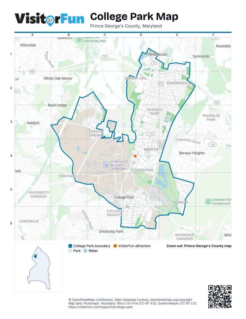
Street index of College Park
Each street on the sheet and the grid squares it crosses.
- Baltimore AvenueD1, D2, D3, D4, C5, D5, C6
- Capital BeltwayD1, D2, E2
- Circle DriveD1
- Ikea Center BoulevardD1
- Ikea WayD1
- Locust Hill DriveD1, E1
- Milestone WayD1
- Second StreetD1
- South DriveD1
- 51st AvenueE1, E2, E3, D4, D5, D6
- 52nd AvenueE1, E2, E3, D6
- Odessa RoadE1, E2
- Paducah RoadE1
- Palco PlaceE1
- Rhode Island AvenueE1, E2, D3, E3, D4, D5, D6
- Stewart CourtE1
- Davidson StreetB2, C3
- Dewberry LaneB2, B3
- Limestone PlaceB2, C2, B3, C3
- Marlbrough WayB2, C2, B3, C3
- Wofford CourtC2
- Wofford LaneC2, C3
- 47th AvenueD2
- 47th PlaceD2
- 48th AvenueD2, D3, D4
- 48th PlaceD2, D3, D4
- 49th AvenueD2, D3, D4
- 49th PlaceD2, E2, D3
- Austin CourtD2
- Autoville DriveD2, D3
- Cherry Hill RoadD2
- Edgewood RoadD2, E2
- Hollywood RoadD2, E2
- Indian LaneD2, D3, E3
- Iroquois StreetD2, D3, E3
- Kiernan RoadD2
- Lackawanna StreetD2, E2
- Laguna RoadD2, E2
- Mangum RoadD2, E2
- Muskogee StreetD2, E2
- Nantucket RoadD2, E2
- Niagara RoadD2, E2
- Park DriveD2
- Park RoadD2
- Peru RoadD2
- 50th AvenueE2, D5
- 50th PlaceE2, D3, E3, D4
- 51st PlaceE2, E3
- 51st TerraceE2
- 52nd PlaceE2
- 53rd AvenueE2, E3
- Kenesaw StreetE2, E3
- Kennebunk TerraceE2
- Keota TerraceE2
- Mineola RoadE2
- Narragansett ParkwayE2
- Niagara PlaceE2
- Ontario RoadE2
- Wichita AvenueE2
- Adelphi RoadA3, B3, B4, B5
- Metzerott RoadA3, B3, C3, D3
- Bridgewater StreetB3, C3
- Duke StreetB3, C3
- Marlbrough CourtB3
- Saint Andrews PlaceB3, C3
- 34th AvenueC3, C4
- 35th AvenueC3, C4
- 36th AvenueC3, C4
- 37th AvenueC3
- 38th AvenueC3
- Acredale CourtC3
- Boteler LaneC3
- Crystal Springs RoadC3
- De Pauw PlaceC3
- Drake PlaceC3
- Gettysburg LaneC3
- Greenmead DriveC3
- Paint Branch DriveC3, C4, D4
- Terrapin TrailC3, C4
- University Boulevard EastC3, D3, B4, C4, D4, E4, B5
- Apache StreetD3, E3
- Blackfoot PlaceD3, E3
- Blackfoot RoadD3
- Branchville RoadD3, E3
- Caddo StreetD3
- Catawba StreetD3
- Cherokee StreetD3, E3
- Delaware PlaceD3, E3
- Delaware StreetD3, E3
- Erie StreetD3, E3
- Fox StreetD3, E3
- Greenbelt RoadD3, D4, E4
- Huron StreetD3, E3
- Locust Spring RoadD3
- Patricia CourtD3, D4
- Cheyenne PlaceE3
- Cree LaneE3
- Eutaw PlaceE3
- Geronimo StreetE3
- Backstage LaneB4, C4
- Curry DriveB4
- Presidential DriveB4, C4, B5
- Stadium DriveB4, C4
- Alumni DriveC4, C5
- Campus DriveC4, D4, B5, C5, D5, D6, E6
- Championship LaneC4, C5
- Chemistry LaneC4
- Denton Service LaneC4
- Engineering DriveC4
- Farm DriveC4
- Fieldhouse DriveC4
- Industrial LaneC4
- La Plata DriveC4
- Landscape LaneC4
- Regents DriveC4, C5
- Shuttle-UM BaseC4, D4
- Technology DriveC4
- Union LaneC4, C5
- Valley DriveC4
- Wellness WayC4
- 54th AvenueD4, D5
- Ash AvenueD4
- Berwyn House RoadD4
- Berwyn RoadD4, E4
- Lakeland RoadD4
- Melbourne PlaceD4
- Mohegan PlaceD4
- Navahoe StreetD4
- Osage StreetD4
- Patuxent AvenueD4
- Pontiac StreetD4
- Potomac AvenueD4, E4
- Quebec StreetD4
- Roanoke PlaceD4, E4
- Ruatan StreetD4
- Seminole StreetD4
- Shuttle-UM Bus WashD4
- Tecumseh StreetD4
- 55th AvenueE4
- Cool Spring RoadB5
- Ehrensberger DriveB5
- Calvert RoadC5, D5
- Calvert Service LaneC5
- Chapel DriveC5
- College AvenueC5, D5, E5
- Cornell AvenueC5
- Fraternity RowC5, D5
- Guilford DriveC5, C6
- Hartwick RoadC5, D5
- Knox RoadC5, D5
- Lehigh RoadC5, D5, E6
- Library LaneC5
- Mowatt LaneC5
- North Library LaneC5
- Preinkert DriveC5
- Rossburg DriveC5
- Rowalt DriveC5
- Union DriveC5
- Bowdoin AvenueD5, D6
- Columbia AvenueD5
- Corporal Frank Scott DriveD5, D6
- Dartmouth AvenueD5, D6
- Diamondback DriveD5
- Dickinson AvenueD5
- Girard AvenueD5
- Graduate WayD5
- Hopkins AvenueD5
- Hotel DriveD5
- Howard LaneD5
- Litton AvenueD5
- Norwich RoadD5
- Pierce AvenueD5
- Princeton AvenueD5
- River RoadD5, D6
- Rossborough LaneD5
- Testudo WayD5
- Yale AvenueD5
- Baylor AvenueE5, E6
- Bryn Mawr RoadE5
- Chestnut Hill RoadE5
- Citadel DriveE5
- Creighton DriveE5
- Edmonston RoadE5, E6
- Knoxville DriveE5
- Radcliffe DriveE5, E6
- Sweetbriar DriveE5
- Vassar DriveE5
- Wellesley DriveE5
- Albion RoadC6, D6
- Amherst RoadC6, D6
- Beechwood RoadC6, D6
- Carleton TerraceC6, D6
- Fordham CourtC6, D6
- Fordham LaneC6, D6
- Guilford RoadC6, D6
- PinewayC6
- Queens Chapel RoadC6
- Clemson RoadD6
- Dartmouth StreetD6
- Drexel RoadD6
- Erskine RoadD6
- Fordham RoadD6
- Guilford PlaceD6
- Harvard RoadD6
- Wake Forest DriveD6
- Wake Forest RoadD6
Places on the map
- 7-Eleven
- Architecture Library
- Art Library
- Calvert Park
- Campus Farm
- Center for Young Children
- Chapel Field
- College Park Airport
- College Park Center
- College Park City Hall
- College Park Marketplace
- College Park Shopping Center
- College Park Woods Park
- Dash In
- Duvall Field
- Engineering Recreation Field
- Fraternity Fields
- Hollywood Shoping Center
- IKEA
- Indian Creek Stream Valley Park
- JTTC
- Lake Artemesia
- Lake Artemesia Park
- Lakeland Park
- McKeldin Mall
- Michelle Smith Performing Arts Library
- National Archives II
- Paint Branch Stream Valley Park
- Saint Andrews Episcopal Church
- SECU Stadium
- Stadium Drive Garage
- STEM Library
- Sunnyside Neigborhood Park
- The UPS Store
- UMGC/University College Garage
- University of Maryland Golf Course
- University of Maryland, College Park
Next to College Park
- Adelphi
- Adelphi Park
- Berwyn Heights
- Buck Lodge
- Chatham
- College Heights
- College Heights Estates
- Franklin Park
- Hillandale
- Hillandale Forest
- Knollwood
- Lewisdale
- Lewiston
- Riverdale Gardens
- Riverdale Park Station
- Rosedale Park
- Sunnyside
- University Gardens
- University Park
- White Oak Manor
© OpenStreetMap contributors, Open Database License, openstreetmap.org/copyright · Map data: Protomaps · Boundary: Who's On First (CC-BY 4.0); Quattroshapes (CC BY 2.0)















