

Maryland map
Prince George's County map
About 966,629 people live here (Census Bureau, 2024 estimate). The sheet's index lists 14 streets; Capital Beltway, Baltimore-Washington Parkway and John Hanson Highway cross the most grid squares. Things to do inside the boundary: Anacostia Trails Heritage Area, Cambria Hotel College Park and National Harbor.
Open the map (PDF, US Letter)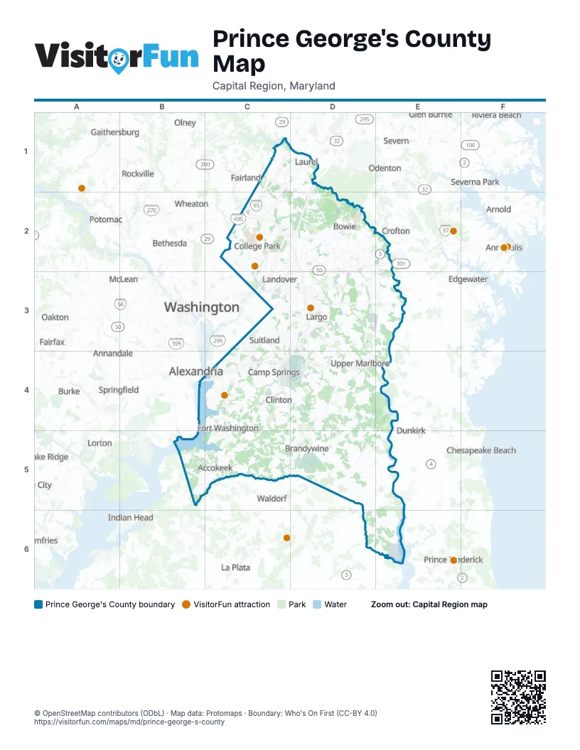
Maps inside Prince George's County
1 map inside, from the street map of Prince George's County down.
Street index of Prince George's County
Each street on the sheet and the grid squares it crosses.
- Intercounty ConnectorC1
- Baltimore-Washington ParkwayD1, C2, D2, C3
- Capital BeltwayC2, D2, D3, C4, D4
- John Hanson HighwayD2, E2, C3, D3
- Kenilworth Avenue FreewayC3
- New York Avenue NortheastC3
- Capital Beltway (Local)B4, C4
- Capital Beltway (Thru)B4, C4
- Woodrow Wilson Memorial Bridge (Local)B4, C4
- Anacostia FreewayC4
- Branch AvenueC4
- National Harbor BoulevardC4
- Pennsylvania AvenueD4
- Stephanie Roper HighwayD4, E4
Things to do on the Prince George's County map
Places on the map
- Accokeek
- Adelphi
- Anacostia River Stream Valley Park
- Andrews East Course
- Andrews South Course
- Aquasco
- Aquasco Farm Park
- Baden
- Bald Hill Stream Valley Park
- Baltimore-Washington Parkway
- Barnaby Run Park
- Beck Lake
- Beltsville
- Berwyn Heights
- Bladensburg
- Bowen Wildlife Management Area
- Bowie
- Bowie Race Track
- Boxwood Village
- Brandywine
- Brandywine Pit
- Brandywine Receiver Station
- Brentwood
- Brock Hall
- Brown Station
- Camp Springs
- Capital Office Park
- Capitol Heights
- Cash Lake
- Cedar Heights
- Cedarville
- Cedarville Trailer Park
- Chaddsford
- Chalk Point Generating Station
- Cherry Hill Park
- Cheverly
- Chillum
- Clinton
- College Park
- Colmar Manor
Next to Prince George's County
- Alexandria
- Annandale
- Annapolis
- Arnold
- Aspen Hill
- Bailey's Crossroads
- Bethesda
- Burke
- Chesapeake Beach
- Colesville
- Crofton
- Dale City
- Dumfries
- Dunkirk
- Edgewater
- Fairfax
- Fairland
- Gaithersburg
- Glen Burnie
- Great Falls
- Indian Head
- La Plata
- Lake Ridge
- Lorton
- McLean
- Merrifield
- Mount Vernon
- North Beach
- North Bethesda
- North Potomac
- Oakton
- Odenton
- Olney
- Pasadena
- Potomac
- Prince Frederick
- Redland
- Riviera Beach
- Rockville
- Severn
- Severna Park
- Silver Spring
- Springfield
- Vienna
- Waldorf
- Washington
- Wheaton
- White Oak
- Woodbridge
© OpenStreetMap contributors (ODbL) · Map data: Protomaps · Boundary: Who's On First (CC-BY 4.0)