

Maryland map
Capital Region map
The sheet's index lists 24 highways; I-495, I-95 and I-270 cross the most grid squares. Things to do inside the boundary: Abraham Hall Historic Site, Acorn Park and Anacostia Trails Heritage Area. Also on it: Accokeek, Aspen Hill and Ballenger Creek.
Open the map (PDF, US Letter)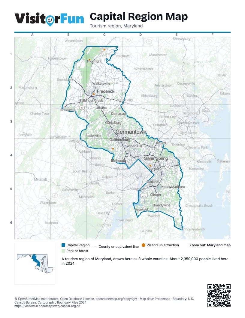
Highway index of Capital Region
Each highway on the sheet and the grid squares it crosses.
- I-70B2, C2, D2
- I-95D4, D5, E4, E5
- I-270C2, C3, C4, D4
- I-295D5
- I-370C4, D3
- I-495C4, D4, D5, E4, E5
- US 15B2, B3, C1, C2
- US 29D4
- US 40C2, D2
- US 50D4, E4
- US 301D6, E4, E5, E6
- US 340B2, B3, C2
- MD 3E4
- MD 4D5, E5
- MD 5D5, D6, E5, E6
- MD 27C3, D2
- MD 140C1
- MD 200D3, D4
- MD 201D4, D5
- MD 210D5, D6
- MD 228D6
- DC 295D5
- MD 337D5, E5
- MD 450E4
Things to do on the Capital Region map
- Abraham Hall Historic Site
- Acorn Park
- Anacostia Trails Heritage Area
- Belair Stable Museum
- Beltway Plaza Mall
- Black Hill Regional Park
- Brookside Gardens
- Buck Branch Stream Valley Park
- Cabin John Creek Stream Valley Park
- Cabin John Regional Park
- Cambria Hotel College Park
- Catoctin Mountain Park
- Clara Barton National Historic Site
- Cunningham Falls State Park
- Dierssen Waterfowl Sanctuary
- Dowden's Ordinary Special Park
- Falls Road Park
- Festival of Lights at Watkins Regional Park
- Gambrill State Park
- Glen Echo Park
- Glenstone
- Great Falls Tavern
- Greenbelt Park
- Heart of the Civil War Heritage Area
- McCrillis Gardens
- MGM National Harbor
- Monocacy National Battlefield
- National Capital Trolley Museum
- National Colonial Farm
- National Museum of Civil War Medicine
- National Museum of Health and Medicine
- National Shrine of Saint Elizabeth Ann Seton
- Oxon Cove Park and Oxon Hill Farm
- Patuxent River State Park
- Piscataway Park
- Rachel Carson Conservation Park
- Rock Creek Regional Park
- Rosaryville State Park
- Sandy Spring Museum
- Seneca Creek State Park
- South Mountain State Park
- The Capital Wheel
- Towne Centre at Laurel
- Weinberg Center for the Arts
- Wheaton Regional Park
Places on the map
- Accokeek
- Aspen Hill
- Ballenger Creek
- Bethesda
- Brandywine
- Brunswick
- Clarksburg
- Clinton
- Damascus
- Frederick
- Gaithersburg
- Germantown
- Landover
- Laurel
- Poolesville
- Silver Spring
- Suitland
- Thurmont
- Upper Marlboro
- Urbana
- Walkersville
Next to Capital Region
- Central Maryland map
- Southern Maryland map
- Western Maryland map
- Dutch Country Roads
- Northern Virginia
© OpenStreetMap contributors, Open Database License, openstreetmap.org/copyright · Map data: Protomaps · Boundary: U.S. Census Bureau, Cartographic Boundary Files 2024