

Maine map
Kennebunkport map
The sheet's index lists 119 streets; Ocean Avenue, Old Cape Road and School Street cross the most grid squares. Things to do inside the boundary: Intown Trolley. Also on it: Bailey Court, Casino Hill and Ebs Cove Lane.
Open the map (PDF, US Letter)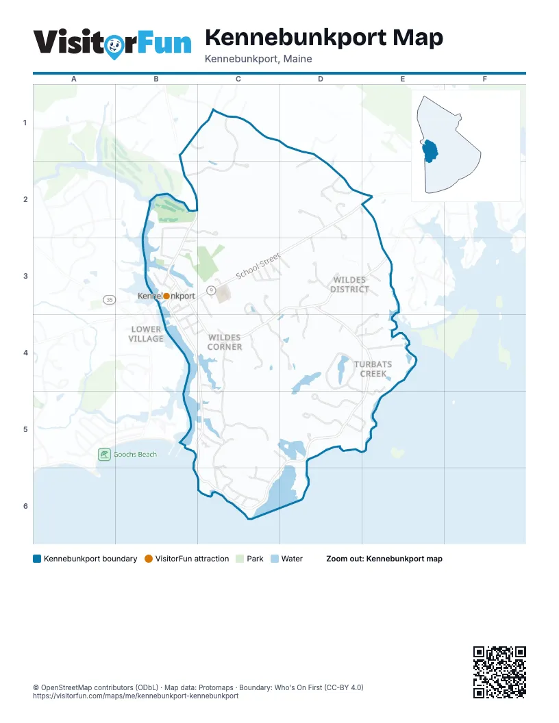
Street index of Kennebunkport
Each street on the sheet and the grid squares it crosses.
- Beachwood AvenueB1, C1
- Hidden Marsh LaneB1, C1
- North StreetB1, B2, B3
- Northwood DriveC1, B2, C2
- Old Cape RoadC1, D1, D2, E2
- Sand Dollar LaneC1
- Tall Pine DriveC1
- Kenneth LaneD1, D2
- Roberts LaneD1
- Locke StreetB2
- Oak StreetB2, B3
- Reid LaneB2, C2
- River RoadB2
- Stonewood LaneC2
- Bailey CourtD2, D3
- Bath LaneD2
- Buttonwood LaneD2, D3
- Capestone DriveD2, E2
- Evening PlaceD2
- Foxberry LaneD2
- Grove StreetD2
- Robin LaneD2
- School StreetD2, E2, B3, C3
- Squier LaneD2
- Old Perkins RoadE2
- Austin's AlleyB3
- Chestnut StreetB3
- Church StreetB3
- Cross StreetB3
- Dock SquareB3
- Elm StreetB3
- Maine StreetB3, C4
- Mast Cove LaneB3
- Meserves LaneB3
- Mill LaneB3
- Ocean AvenueB3, B4, C4, E4, B5, C5, D5, E5, B6, C6, D6
- Pearl StreetB3, B4
- Spring StreetB3
- Temple StreetB3
- Union StreetB3
- Vernon PlaceB3
- Wesmore LaneB3
- West StreetB3
- Western AvenueB3
- Acacia RoadC3
- Birch CourtC3
- Briarwood LaneC3, D3
- High StreetC3
- Laurel RoadC3
- Magnolia DriveC3
- Primrose LaneC3
- Recreation WayC3
- Sherwood DriveC3
- Towne StreetC3, C4
- Wakefield Pasture RoadC3, C4
- Washington CourtC3, D3
- Wildes District RoadC3, D3, E3, C4
- Woodlawn AvenueC3, C4
- Bufflehead LaneD3, E3
- Echo Ledge LaneD3
- High Point DriveD3
- Lakehouse LaneD3, E3
- Lynnsey HollowD3, D4
- Maplewood DriveD3, D4
- Obed LaneD3, E3
- Olde Wildes Farm RoadD3
- Port Farm RoadD3
- Saddle WayD3
- Turbats Creek RoadD3, D4, E4
- Winslow LaneD3
- Browns LaneE3
- Ebs Cove LaneE3, D4, E4
- McKenney LaneE3
- White Creek LaneE3
- Greene StreetB4, C4
- Pleasant StreetB4
- South StreetB4, C4
- Wharf LaneB4
- Arbor Ledge DriveC4
- Cornbrook LaneC4
- East AvenueC4, C5
- Juniper Knoll LaneC4
- Merrymeeting LaneC4
- Rocky Pasture LaneC4, D4
- South Main StreetC4, C5
- Creek SideD4
- Crestview LaneD4
- Daisy LaneD4
- Dragonfly LaneD4
- Nehoc LaneD4, E4
- Oakwood DriveD4, D5, E5
- Beach Rose LaneE4
- Chart House RoadE4
- Field Point RoadE4
- Halcyon WayE4, E5
- Rita RoadE4
- Timber Ledge LaneE4
- Arlington AvenueC5, C6
- Colony AvenueC5
- Dover LaneC5, C6
- Grandview AvenueC5
- Ivy LaneC5
- Joshua Curtis LaneC5
- Poets LaneC5, C6
- Sandy Cove RoadC5, D5
- Spring Valley RoadC5
- Woodland DriveC5
- WOODLAND DRIVEC5
- Elizabethan DriveD5
- Ocean Sound DriveD5
- Washburn DriveD5
- Windemere PlaceD5, E5
- Atlantic AvenueC6
- Central AvenueC6
- Endcliffe RoadC6
- Haverhill AvenueC6
- Old Fort AvenueC6
- Spouting Rock AvenueC6
- Summit AvenueC6
Things to do on the Kennebunkport map
Places on the map
- Bailey Court
- Casino Hill
- Ebs Cove Lane
- Evening Place
- Foxberry Woods
- Grist Mill Pond
- Grove Street
- James Woods
- Juniper Knoll Condos
- Kennebunkport
- Kennebunkport Consolidated School
- Kennebunkport Fire Department Village Station
- Kennebunkport Fire Department Wildes District Station
- Kennebunkport Historical Society Library
- Kennebunkport Inn
- Kennebunkport Post Office
- Kennebunkport Town Office
- Louis T Graves Memorial Public Library
- Ocean Sound Drive
- Parson's Field
- Prospect Hill
- Saint Anns by the Sea Episcopal Church
- School Street Cemetery
- Shawmut Woods
- Squier Lane
- The Boathouse Waterfront Hotel
- The Colony Hotel
- The Edgewater Inn
- The Nonantum Resort
- Wallace Woods
- Yachtsman Lodge & Marina
Next to Kennebunkport
- Cape Porpoise
- Coopers Corner
- Lower Village
- Town House Corners
© OpenStreetMap contributors (ODbL) · Map data: Protomaps · Boundary: Who's On First (CC-BY 4.0)