

Michigan map
Garfield Charter Township map
About 19,916 people live here (Census Bureau, 2024 estimate). The sheet's index lists 300 streets; West South Airport Road, North Garfield Road and North Keystone Road cross the most grid squares. Also on it: Garfield Township, Hickory Hills Recreation Area and Hickory Meadows.
Open the map (PDF, US Letter)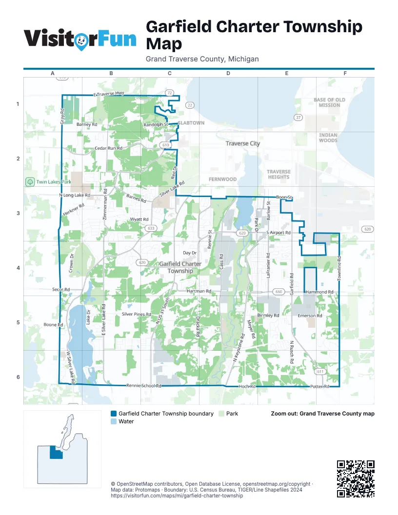
Street index of Garfield Charter Township
Each street on the sheet and the grid squares it crosses.
- West South Airport RoadD3, E3, F3, B4, C4, D4
- North US 31 SouthC3, C4, C5, C6
- North Garfield RoadE3, E4, E5, E6, F6
- West Potter RoadE6, F6
- East Traverse HighwayB1, C1
- South Garfield AvenueE3
- US 31 SouthC6
- East South Airport RoadF3
- South Division StreetC3
- South Garfield RoadF6
- Cass RoadD3, D4, D5
- North Keystone RoadE3, D4, E4, D5, D6
- North West Silver Lake RoadA4, B4, A5, A6
- North Long Lake RoadB2, C2, A3, B3
- Silver Lake RoadB3, C3, B4
- West Hammond RoadD4, E4, F4
- West Front StreetC2
- Lloyd LaneD4, E4
- East Hammond RoadF4
- South Cass StreetD3
- South West Silver Lake RoadA6
- North East Silver Lake RoadB4, B5, B6
- Cedar Run RoadA2, B2, C2
- Zimmerman RoadB2, B3, B4
- LaFranier RoadE3, E4, E5
- Harris RoadB1, B2
- Hartman RoadC4, D4
- Veterans DriveC3, D3
- Barlow StreetE3
- Barnes RoadB3, C3
- Gray RoadA1
- Park DriveD3, E4
- Franke RoadC3
- Woodmere AvenueE3
- Secor RoadA4, B4
- Premier StreetD3, E3
- Silver DriveC2
- South East Silver Lake RoadB6
- Barney RoadA1, B1, B2, C2
- Silver Pines RoadB5, C5
- Dracka RoadC4, C5, C6
- Townline RoadF3, F4, F5
- Arborview DriveC4, D4
- Rennie School RoadB6, C6
- McRae Hill RoadC4, C5
- West Crown DriveA4, B4
- North Rusch RoadE5, E6
- Orchard Circle DriveE4
- Meyer RoadD5
- Silver Farms LaneB3, B4
- Birmley RoadD5, E5
- Herkner RoadA3, B3
- Spring Hill RoadE5, F5
- Wyatt RoadB3, C3
- Hoch RoadD6, E6
- Liberty DriveB3
- Hughes DriveE4, E5
- Westbrook DriveA2
- Boardman/Ottaway River TrailD5, D6
- Stone Ridge DriveC3, B4, C4
- Gallagher DriveA2
- Birmley Estates DriveE5
- Chelsea LaneC4
- Emerson RoadE5, F5
- East Crown DriveB4
- Jefferson AvenueC1
- Meadow Lane DriveB5, C5
- Broad RoadD5, C6, D6
- Umber DriveE5
- Industry DriveE5
- Lone Beech DriveB2
- Friendship DriveD4
- Ashland DriveE5
- Hidden Glen DriveA1, A2
- Boon StreetE3
- Lake DriveB5
- Rennie StreetD3, D4
- Valley DriveB5
- Ray BoulevardD4, E4
- Leisure LaneD4
- Sheffer Farm RoadB3
- Windmill LaneF5, F6
- Grayhawk BoulevardB2, C2
- Randolph StreetC1
- Creekside DriveC3, C4
- Ridgemoor DriveB2
- Roman DriveB6
- Andrew PlaceD4, E4
- Hidden Creek DriveB4, C4
- Heritage WayA3, B3
- Crossing CircleC4, D4
- Northern Star DriveE4, E5
- Highland DriveB5, B6
- La Casita AvenueD3
- Harbor Hill DriveE4
- Treelane DriveD4
- Farmington DriveE5
- Country Club DriveD3
- Hemingway LaneE4
- Goldenrod DriveB5
- Red DriveC2
- Alice LaneA6
- Summerfield LaneD4, E4
- Blue Ridge LaneB4
- Woodward AvenueE3
- Stonefield DriveB2
- London DriveA5
- Incochee Woods DriveC1
- Meadow Lane BoulevardB5
- Ridge Trail DriveC4
- Terra RoadE4
- Buckhorn DriveB3
- Hearthside DriveB3, C3
- Racquet Club DriveD3, D4
- Geraldton PlaceD4, E4
- Bay Meadows DriveB1
- Pembrook DriveA3
- Gaddi DriveB3
- Powder Horn DriveB3
- Briarcliff DriveB3, C3
- Kyselka RoadC5
- West Blue Star DriveC5, C6
- Oak Terrace DriveE4
- West Royal DriveC2
- Lillian LaneA6
- Paul PlaceD4, E4
- Glastonbury CircleF5
- Elmers Industrial DriveC6
- David PlaceD4, E4
- Eagles ViewC3
- Arlington LaneB3
- Linden AvenueE3
- Boardman Lake DriveD3
- Brook DriveC3
- Silver Valley LaneB3, B4
- Buteo DriveB2
- Day DriveC4
- Benzonia State RoadB1
- Wooded Valley DriveF6
- Matador WestC3, D3
- Traditions DriveE5
- Copper Ridge DriveC3
- Lone Pine DriveB2, B3
- Keystone DriveD6
- Emerald Bluffs DriveC4, D4
- Lake Pointe DriveD3
- Finehout DriveB6
- Sunrise LaneB3
- Medical Campus DriveC2
- Silver Lake Shores RoadB6
- Boone RoadA5
- Calla Lilly LaneC5
- Molon DriveD4
- Meadow DriveB5, B6
- Apple Tree LaneB2
- Northridge DriveB3, C3
- Olesons Commerce DriveC6
- Sundowner DriveC6
- Brunson PlaceB4
- Trade Centre DriveE5
- North Royal DriveC2
- Townhouse LaneE4
- East Colonial DriveB3
- Boardman View DriveD6
- Terrace Bluff DriveE3
- Village Lane CourtB3
- Culver RoadA6
- Sandia PlaceD3
- Duell RoadE3
- Cherry LaneB3
- Elmer's Asphalt DriveC6
- Ra-Wa-Si AvenueB4
- Eastview DriveC3
- Ahlberg RoadD5, E5
- Westward DriveB4
- Lone Tree RoadB2
- Ruben LaneC6
- Timberwolf DriveB3
- Lunatic LaneD5
- Courtney PlaceC3
- Glen DriveE4
- Westchester CommonsB3
- Vista ParkD3
- North Country DriveC4
- Incochee RoadC1
- Knoll Crest CourtE4
- Polaris CrescentC5
- Keystone Hills DriveD5
- Brigadoon CourtD3
- Alhambra DriveF5, F6
- Summit View DriveB3
- Dover LaneA5
- Westridge CourtB3
- Shenandoah DriveB4
- Summerhill RoadC3
- Foxcraft DriveB2, B3
- Princeton DriveD3
- Cedar Valley DriveC3, C4
- Forest Ridge DriveD3
- Concord StreetC3, D3
- Contractors DriveD3, D4
- Paysage PlaceB3
- Marketplace CircleC3
- Birch Tree LaneE4
- Kchi-Wiikwedoong MiikanA3
- Woodside DriveB3
- Cole DriveA5, A6
- Cluster DriveD4
- Old Incochee Farm TrailC1
- Ridge BoulevardE4
- Dendrinos DriveD3
- Glenview LaneE3
- Hedwidge DriveB4
- Manor LaneE3
- Memorial South CommonsC6
- Shady LaneE3
- Sweet Breeze LaneB1, B2
- Briar Hill LaneE3
- Newport StreetE3
- Ahgosa MiikaansA3
- Eaglehurst DriveB3
- Deerfield LaneB3, C3
- Devotion DriveB3
- Larkspur DriveB5, C5
- Phils TrailF5
- Gladewood LaneE3
- Hickory Hills TrailB1
- Plum Valley DriveB3
- Pineview DriveC3, C4
- Ramsdell StreetC1
- Crescent StreetE3
- Manitou DriveE4
- Hammond Place EastE4
- Linwood LaneE3
- Mikhail BoulevardC4
- Hill Valley DriveA3
- Silver Shores LaneB5
- Scenic Ridge DriveC3
- Orthwoods DriveC3
- Rock CourtC4
- Alexander DriveE5
- West Buttercup LaneB5
- Cass Hartman CourtD4, D5
- Feiger LaneC3, D3
- Horseshoe DriveC4
- Rusch View RidgeE6
- Robinwood CourtE3
- Beech Tree LaneE4
- Silverwood DriveB5
- Blue Spruce DriveB5
- Chicory LaneC5
- Porsche CourtB5
- Anna DriveC2
- Pine Meadow LaneB2
- North Forestlane DriveE3
- Panorama LaneB3
- Floresta StreetE3
- Old Orchard TrailB3
- South Forestlane DriveE3
- Sybrant RoadD3
- Green Meadows DriveB4
- Ravenhurst DriveB3
- Frank StreetD4, E4
- Orchid TrailB5
- Mizar CourtC5, C6
- MaylaneE4
- Bi-Waaseyaa MiikaansA3
- Rosewood DriveB3
- Windy Acres LaneA1
- Foxfire DriveB2
- South Blue Star DriveC6
- Heatherwood Drive EastB3
- Victoria DriveD3, D4
- Silver Cove DriveB5
- Keane DriveE5
- South Colonial DriveB3
- William PlaceE4
- Crestview DriveC3
- Applefield DriveE4
- South Silver Lake View CourtB5
- Valley LaneC3
- Alcor DriveC5, C6
- Laura DriveD5
- Pebblestone DriveB2
- Astro PlaceF3, F4
- Incochee Hill DriveC1
- Cobalt StreetE5
- Sunset LaneC3
- Garden CourtB3
- Kent StreetE3
- Orchard Hill ParkwayE4
- MorningsideD3
- North Silver Lake View CourtB5
- Park Forest DriveC3
- Northwind DriveC6
- Springcress LaneB5
- West Daisy LaneB5
- Sienna StreetE5
- East Carriage Hill DriveE4
- Neuman StreetA6
Places on the map
- American Waste
- Bay Meadows Golf Course
- Bison Hollow
- Boardman River
- Boardman Valley Nature Preserve
- Buffalo Ridge Shopping Center
- Cherryland Center
- Copper Ridge
- Garfield Township
- Grand Traverse Commerce Center
- Grand Traverse Commerce Park
- Grand Traverse Crossing
- Grand Traverse Mall
- Grand Traverse Natural Education Reserve
- Great Wolf Lodge
- Hammond Commerce Centre
- Handle With Care Packaging Store
- Hickory Forest Natural Area
- Hickory Hill
- Hickory Hills Recreation Area
- Hickory Meadows
- Hidden Lake
- Historic Barns Park
- Keystone Soccer Complex
- Kids Creek Park
- Little Silver Lake
- Logan Place West
- Logan's Landing West
- Lynch Industrial Park
- McCrea Hill
- Meadow Valley
- Medalie Park
- Miller Creek Nature Reserve
- Mitchell Creek Nature Sanctuary
- River East Recreation Area
- Silver Lake
- Silver Lake Recreation Area
- The Crown Golf Club
- The Village at Grand Traverse Commons
- Traverse City Golf and Country Club
Next to Garfield Charter Township
- Base of Old Mission
- Fernwood
- Indian Woods
- Kids Creek
- Oak Park
- Old Towne
- Slabtown
- Traverse City map
- Traverse Heights
© OpenStreetMap contributors, Open Database License, openstreetmap.org/copyright · Map data: Protomaps · Boundary: U.S. Census Bureau, TIGER/Line Shapefiles 2024















