

Michigan map
Traverse City map
About 15,435 people live here (Census Bureau, 2024 estimate). The sheet's index lists 300 streets; East Front Street, South Garfield Avenue and South Division Street cross the most grid squares. Things to do inside the boundary: Grand Traverse Pie Company and The Village at Grand Traverse Commons.
Open the map (PDF, US Letter)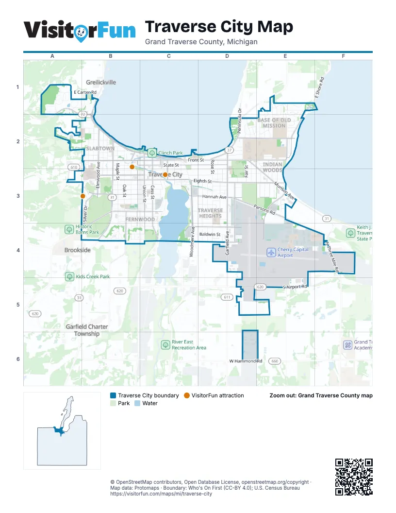
Street index of Traverse City
Each street on the sheet and the grid squares it crosses.
- East Front StreetC2, D2, E2
- West Grandview ParkwayB2, C2
- South Garfield AvenueD2, D3, D4
- South Division StreetB2, B3, B4
- East Grandview ParkwayC2
- Munson AvenueD2, E2, E3
- Peninsula DriveD2
- West South Airport RoadD5, E5
- East Traverse HighwayA1, B1, B2
- North Three Mile RoadF4
- East South Airport RoadE5
- South West Bay Shore DriveB1, B2
- North Division StreetB2
- North Garfield AvenueD2
- Center RoadD2
- East Eighth StreetC3, D3, E3
- South Cass StreetC2, C3, C4
- South Union StreetC2, C3, C4
- West Front StreetB2, C2, A3
- Silver Lake RoadB3, A4
- West Fourteenth StreetB3, C3
- West Hammond RoadD6, E6
- East Fourteenth StreetC3
- North Union StreetC2
- Woodmere AvenueC3, C4
- East State StreetC2, D2
- Hannah AvenueC3, D3, E3
- Airport Access RoadE3, E4
- Parsons RoadD3, E3
- Pine StreetB2, B3, B4
- Hastings StreetD3, D4
- Carver StreetC4, D4
- West Eleventh StreetB3, C3
- Eastern AvenueD2, E2
- Birchwood AvenueE1, E2
- Bay StreetB2
- Boon StreetC4, D4
- Silver DriveB3, A4, B4
- Seventh StreetB3, C3
- Veterans DriveB3, B4
- South Elmwood AvenueB2, B3
- North Elmwood AvenueB2
- West Eighth StreetB3, C3
- North East Bay BoulevardE2
- Boardman AvenueC2, C3
- Hall StreetB2
- East Shore RoadE1
- West State StreetB2, C2
- Franke RoadA4
- North Cass StreetC2
- Park StreetC2
- North Park StreetC2
- Barlow StreetC2, C3, C4
- Rose StreetD2, D3, D4
- Washington StreetC3, D3
- Fly Don't DriveE4, E5
- Sixth StreetB2, B3, C3
- South Maple StreetB2, B3
- Webster StreetC3, D3
- Wayne StreetA2, B2
- Aero-Park DriveE4, F4
- College DriveD2, E2
- Randolph StreetA2, B2
- South Oak StreetB2, B3
- Fern StreetD3, D4
- Wadsworth StreetB2, B3
- Grant StreetD3, D4
- Centre StreetC3, D3
- Locust StreetC3
- Monroe StreetB2
- East Timberlane DriveE1, E2
- Bates StreetD3
- Baldwin StreetC4, D4
- Lake AvenueC3
- West Thirteenth StreetB3, C3
- West Twelfth StreetB3, C3
- West Tenth StreetB3, C3
- West Ninth StreetB3, C3
- North Aero-Park CourtE4
- West Griffin StreetB3, C3
- Old Morgan TrailA1
- North Spruce StreetB2
- Bay Hill TerraceB4
- Traversefield DriveD6
- South Meridian DriveA1, B1
- West Fifteenth StreetB3, C3
- Kelley StreetC3, D3
- Boyd AvenueC3, D3
- North Madison StreetB2
- Third StreetB2
- North Cedar StreetB2
- Franklin StreetC2, C3
- Wellington StreetC2, C3
- Lake Ridge DriveC3
- South East Bay BoulevardE2, E3
- Second StreetB2
- Wenonah StreetE2, E3
- Indian Trail BoulevardE3
- Fair StreetD2, D3
- Highland Park DriveE2
- Huron Hills DriveE1, E2
- Bloomfield RoadE2
- Whittington StreetA1
- Sheridan RoadD2
- Quail Ridge DriveE2
- Milliken DriveD2
- Kewaunee DriveE1, E2
- Indian Woods DriveE2
- Railroad AvenueC2, C3
- Huron StreetE2, E3
- Cochlin StreetD2, D3
- Station StreetC3
- Boughey StreetB4, C4
- Fairlane DriveB4, C4
- Titus AvenueD3
- Cottageview DriveB3
- Edgewater RidgeC3, C4
- West Sixteenth StreetB3, C3
- East Tenth StreetC3
- West Orchard DriveD2
- Timber Lane DriveE1
- Arrowhead DriveE1, E2
- Ramsdell StreetA2, B2
- Fifth StreetB2
- Kinross StreetD3
- South Ellis AvenueA1
- Cromwell DriveE3
- East Orchard DriveD2
- Shrewbury StreetA1
- East Ninth StreetC3
- South Civic Center DriveD2, D3
- Medical Campus DriveB3
- Davis StreetE2, E3
- East Eleventh StreetC3
- East Carter RoadA1
- Stults DriveE4
- Hamilton StreetD2, D3
- Centre PlaceC3
- East Twelfth StreetC3
- Sheffer StreetC3, C4
- Woodland DriveE3
- Judson StreetE4, E5
- Terrace DriveE3
- Georgetown DriveB3, B4
- South Compass Rose DriveA1
- Fitzhugh DriveB4
- Belmont DriveE3
- Anderson RoadD2
- Grove StreetC3, D3
- Camrose CircleA1
- Red Fox RunE1
- Bay Hill DriveB4
- Clinch StreetD4
- West Aero-Park CourtE4
- Duell RoadD5
- Leeward TrailE2
- Lincoln StreetD3
- Walnut StreetD3
- Steele StreetD3
- South Spruce StreetB2, B3
- South Cedar StreetB2, B3
- Beadle StreetD3, E3
- Jefferson AvenueB2
- Wright DriveE4, E5
- East Sixteenth StreetC3
- Hill StreetB2
- Westminster RoadE3
- Apache PassE2
- North Maple StreetB2
- Marina DriveC2
- Peninsula CourtD2
- East Fifteenth StreetC3
- North Oak StreetB2
- West Seventeenth StreetB4, C4
- Waterford RoadA1
- Michigan AvenueD3
- Nineteenth StreetB4, C4
- Red DriveB3, B4
- Prospect StreetD3
- Santo StreetD4
- Brook StreetB3
- Nakoma DriveE1, E2
- Eastwood AvenueD2
- Avenue BE3
- South Winding TrailA1
- North Orchard DriveD2
- Incochee Woods DriveA1, A2
- Midtown DriveC3
- Riverine DriveC3
- Chippewa StreetE3
- Iroquois StreetE2
- Willow StreetB2
- East Seventeenth StreetC4
- East Thirteenth StreetC3
- East Griffin StreetC3
- Shawnee StreetE2
- Coventry TrailE2
- Cherry Lane DriveE2
- Newcomb StreetC3, C4
- Sequoia StreetE3
- Birchwood CourtE2
- Comanche StreetE2
- Hope StreetC2, C3
- South Madison StreetB2, B3
- East Jennings DriveA1
- Fairway Hills DriveC4
- Incochee RoadA2
- Karla LaneD3
- Munson PlaceE2, E3
- South Lovell LaneA1
- Railroad PlaceC3
- Belanger LaneB3
- Lake Ridge CircleC3
- Rose CourtD4
- South Azimuth DriveA1
- Townline RoadE5
- South Orchard DriveD2
- West Civic Center DriveD2
- Circle AvenueB2
- Arnold CourtB3, B4
- Aston LaneA1
- South Celestial RidgeA1
- Arbutus CourtD4
- Pine Ridge DriveE1, E2
- Milliken CourtD2
- Pavilions CircleB3
- Watch Hill LaneA2
- Continental DriveE5
- Plainview AvenueD4
- Cherokee StreetB2
- Beaumont PlaceB2, B3
- Manor AvenueD2
- Wood AvenueD3
- Georgetown PlaceB4
- Eastgate PlaceE3
- Calvin DriveE3
- Forest Park DriveB3, B4
- Gillis StreetB2
- Kaukauna CourtE1, E2
- Oakland StreetD3
- Union AlleyD3
- Aspen DriveE2
- Cuyahoga CourtE1
- Ahgosa TrailE3
- Court StreetC3
- Allouez TrailE2
- Cypress StreetB2
- Fulton StreetB2
- Gray DriveB3
- Business Park DriveF4
- Randall CourtD2
- East LaneC4
- Seneca StreetE3
- West LaneB4
- North College DriveE2
- Beech StreetB2
- High StreetB4
- Pine Bluff DriveA1
- Oakdale DriveD3
- Kingston CourtA2
- East Carter CentreA1
- Gilbert StreetD2
- Pinecrest AvenueD2
- East Haviland TrailA1
- Western AvenueE2
- Center LaneB4
- Hughes DriveD6
- River's Edge DriveC3
- Candleton CourtA1
- Hillcrest CourtB2
- Xavier StreetB2
- Brown DriveB3
- Tart Trail LaneD3
- Leeward CourtE2
- Pine Needle LaneD2
- Gallery CourtD3
- Uptown CourtB2
- East Bay CourtE2
- Beitner StreetC3
- Campanile SquareA1
- Alcona CourtE2
- Beth El WayC3
- Vine StreetB2
- Kewaunee CourtE1, E2
- North Barlow StreetC2
- Alpine DriveE1
- Drivers Edge LaneC3
- Depot View DriveC3
- North Quail CourtE2
- South Quail CourtE2
- Depot CourtC3
- Elder StreetB2
- Cottage Arbor LaneB3
- Yellow DriveB3
- Perry StreetE3
- Old Incochee Farm TrailA2
- North Forestlane DriveD4
- Astro PlaceE5
- Incochee Farm LaneA2
- Shrewbury/AstonA1
Things to do on the Traverse City map
Places on the map
- Base of Old Mission
- Boardman Lake
- Boardman Neighborhood
- Central Neighborhood
- Cherry Capital Airport
- Clinch Park
- Coast Guard Ramp
- Dutmers Natural Area
- Eastern Elementary School
- Front Street District
- Fulton Park
- Grand Traverse Commons Natural Area
- Grand Traverse County Civic Center
- Grand Traverse Law Library
- Grand Traverse Pavilions
- Hannah Park
- Hull Park
- Indian Woods
- Kayak Launch Park
- Kids Creek
- Midtown Centre
- Munson Medical Center
- NMC Library
- North Boardman Lake District
- NorthwestEd Creekside School
- Northwestern Michigan College
- Oak Park
- Oakwood Cemetery
- Oakwood Triangle
- Old Town District
- Old Towne
- Open Space Park
- Silverbrook Acres
- Slabtown
- The UPS Store
- Traverse City Central High School
- Traverse Heights
- Trojan Athletic Complex
- Warehouse District
- West End Park
Next to Traverse City
- Brookside
- Garfield Charter Township map
- Greilickville
© OpenStreetMap contributors, Open Database License, openstreetmap.org/copyright · Map data: Protomaps · Boundary: Who's On First (CC-BY 4.0); U.S. Census Bureau















