

Michigan map
Grand Traverse County map
About 96,625 people live here (Census Bureau, 2024 estimate). The sheet's index lists 300 streets; Center Road, Peninsula Drive and Supply Road cross the most grid squares. Things to do inside the boundary: Traverse City, Chateau Grand Traverse and Clinch Park.
Open the map (PDF, US Letter)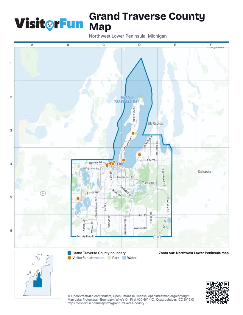
Maps inside Grand Traverse County
3 maps inside, from the street map of Grand Traverse County down.
City
Street index of Grand Traverse County
Each street on the sheet and the grid squares it crosses.
- Center RoadD2, D3, C4, D4
- Peninsula DriveD2, C3, D3, C4
- South M 37C5, C6
- East M 113D6, E6
- US 31 NorthD3, D4
- East M 72D4, E4
- US 31 SouthB5, C5
- South Garfield RoadC5, D5
- US 131E5, E6
- West South Airport RoadC4, D4
- North Three Mile RoadD4, D5
- North US 31 SouthC4, C5
- West M 113C6, D6
- North Garfield RoadC4, C5
- Vance RoadC5
- M 186D6, E6
- East Front StreetC4, D4
- Lautner RoadD4
- West Grandview ParkwayC4
- South Garfield AvenueC4
- Munson AvenueC4, D4
- East Traverse HighwayB4, C4
- South Division StreetC4
- East Grandview ParkwayC4
- Town Center DriveD4
- West Potter RoadC5, D5
- East South Airport RoadD4
- West State StreetC4, E6
- North Brownson AvenueD5, D6
- West Main StreetD6
- North Division StreetC4
- East Main StreetD6
- North Garfield AvenueC4
- M-72 WestE4
- South US 31 HighwayD3
- South West Bay Shore DriveC4
- Supply RoadD4, D5, E5
- County Road 633C5, C6
- North Long Lake RoadB4, C4
- Karlin RoadB5, B6
- West County Line RoadB6, C6
- Elk Lake RoadD3, D4
- Williamsburg RoadD4, E4, D5
- Fife Lake RoadE5, E6
- South Hobbs HighwayD5
- East Hammond RoadD4
- North Four Mile RoadD4, D5
- Voice RoadD5
- Cass RoadC4, C5
- North Keystone RoadC4, C5
- West River RoadC5, D5
- North West Silver Lake RoadC4, C5
- Silver Lake RoadC4
- J Maddy ParkwayB5
- Nessen RoadB6
- East Eighth StreetC4
- High Lake RoadD4, D5
- West Hammond RoadC4, D4
- North Hobbs HighwayD4, D5
- Beitner RoadC5
- West Front StreetC4
- South West Silver Lake RoadC5
- Clark RoadD5, D6
- South Cass StreetC4
- South Three Mile RoadD5
- South Union StreetC4
- County Line RoadC6
- South Keystone RoadC5
- West Fourteenth StreetC4
- Maple StreetB4, C5, E6
- East Fourteenth StreetC4
- Lloyd LaneC4
- North Union StreetC4
- Hobbs/Supply CutoffD4
- North 13 RoadC6
- North Five Mile RoadD4
- Supply Road SouthwestE5
- Cedar Run RoadB4, C4
- Walton RoadD6
- Summit City RoadD5, D6
- Bates RoadD3, D4
- Brown Bridge RoadD5, E5
- Wilson RoadD3, C6
- East County Line RoadD6, E6
- East Duck Lake RoadC5
- Townline RoadD4, D6
- Blackman RoadD6
- West Long Lake RoadB4, B5
- West Blair Townhall RoadC5
- West Center RoadC6, D6
- Five Mile RoadD4
- Youker RoadB5, C5
- Schell RoadB6, C6
- Miller RoadC6
- Angell RoadD3, E3
- South South Long Lake RoadB5, C5
- East River RoadD5
- Ranch Rudolf RoadD5
- North East Silver Lake RoadC4, C5
- Betsie River RoadB5, B6
- Diamond Park RoadB5
- East Shore RoadD4
- Woodmere AvenueC4
- East State StreetC4, E6
- Gray RoadD3, C4
- North South Long Lake RoadC4, C5
- South Betsie River RoadB5
- Barlow StreetC4
- East Long Lake RoadC4
- Hilltop RoadC5
- Knight RoadD5, D6
- Davis RoadB6, C6
- Holiday RoadD4
- Baggs RoadE4
- Secor RoadC4
- Traverse RoadB6
- Parsons RoadC4, D4
- Zimmerman RoadC4, B5
- Old Mission RoadD2
- Veterans DriveC4
- LaFranier RoadC4
- Hannah AvenueC4
- Harris RoadC4
- Pine StreetC4, B5, E6
- Bay StreetD2, C4
- Airport Access RoadC4, D4
- Hartman RoadC4
- South East Silver Lake RoadC5
- Island View RoadD3
- Fenton RoadD6
- Fall RoadC5
- Hastings StreetC4
- Seventh StreetC4, B5
- Carver StreetC4
- Tilton RoadB4
- West Eleventh StreetC4
- Eastern AvenueC4, D4
- Goodrick RoadB4
- Strait RoadC4
- Birchwood AvenueD4
- Church RoadB4
- Barnes RoadC4
- Boon StreetC4
- East Center RoadD6
- Silver DriveC4
- Bowers Harbor RoadD3
- Mission RoadD2
- Arbutus Hill RoadD5
- Park DriveC4
- North Boyd StreetE6
- South Elmwood AvenueC4
- Franke RoadC4
- South Brownson AvenueD6
- North 29 1/2 RoadD6
- North Elmwood AvenueC4
- West Eighth StreetC4
- Fenton StreetD6
- Park StreetC4, C5, D6
- Rhodes RoadB5
- Lindy RoadB6
- North East Bay BoulevardD4
- Boardman AvenueC4
- Premier StreetC4
- Ranch Rudolph RoadD5
- Hall StreetC4
- Coster Road SouthwestE6
- North Cass StreetC4
- North Park StreetC4
- Ingersoll Road SouthwestE6
- North 9 RoadC6
- East Sparling RoadD6, E6
- Hannah RoadC5, C6
- North Broomhead RoadE4, E5
- Bunker Hill RoadD4
- Bluff RoadD3
- Cedar Creek RoadD5, E5
- Marsh RoadD5, E5
- Hodge RoadD5, D6
- Barney RoadC4
- Mill RoadC5
- Carpenter Creek RoadD5, E5
- Clous RoadC5, D5
- Jackpine RoadD5, E5
- Dell RoadD6
- Harrand RoadC6
- Ramsay RoadB6, E6
- Zue RoadB6, C6
- Grand-Kal RoadE5, E6
- Smokey Hollow RoadD2, D3
- Rennie Lake RoadD5
- Skegemog Point RoadE3, E4
- Mayfield RoadD5, E5
- Vans LaneD6, E6
- Ne-Ah-Ta-Wanta RoadD3
- Schichtel RoadC6
- West Hammer RoadC6, D6
- Gonder RoadB5
- Fisher RoadB4, B5
- Moore RoadD4
- Matchett RoadC6
- Sand Lakes RoadD4, E4
- Fryzelka RoadB6, C6
- East Arbutus Lake RoadD5
- East Potter RoadD5
- Rahe RoadC5, C6
- Lake Shore DriveC5, E6
- Hoosier Valley RoadC5
- West Elliott RoadC6
- Kingsley RoadD6
- Bass Lake RoadC4, C5
- Gleaner Hall RoadD6
- Riley RoadB5
- Lake RoadE5, E6
- Old M 72D4, E4
- Island View DriveD5
- Herkner RoadC4
- Brackett RoadD4
- Rasho RoadD4, D5
- Whispering TrailD2
- Florey's Ranch RoadC5, C6
- Cook RoadE4
- Guernsey Lake RoadE4, E5
- Cram RoadD4, E4
- Bush RoadB5
- Vinton RoadE4
- Bowerman RoadD6
- Schneider RoadC5, C6
- Sayler RoadD4
- Hency RoadC6
- Munro RoadD3
- Hamlin RoadC5
- Norton RoadC5
- Jewell RoadB6
- Pierce RoadD5, D6
- Peninsula TrailD5
- Swaney RoadD2
- Rennie School RoadC5
- Cedar Lake RoadB4
- Prouty RoadD4
- Scharmen RoadD5
- North Branch RoadE5
- Bartlett RoadD4, C6
- Jeffrey PlaceC5
- Bennett RoadD4
- Sawyer RoadC5
- Yuba RoadD3, D4
- Peninsular Shores DriveC5
- State Park HighwayB5
- South Rusch RoadC5, D5
- Lackey RoadE4
- East Sleights RoadD5
- South Kroupa RoadD3
- Silver Pines RoadC4
- Dracka RoadC4, C5
- West Barratt RoadC6, D6
- Crisp RoadD4
- Kroupa RoadD3
- Deal RoadE4
- South Broomhead RoadE5
- Elk Lake TrailE3
- Rose StreetC4, B6
- North Spider Lake RoadD5
- Underwood RidgeD4
- Round Lake RoadB5
- Arborview DriveC4
- Hawley RoadD4
- Park RoadD4, E4
- Hoch RoadC5
- East Blair Townhall RoadD5
- Galvin RoadC5
- Randolph StreetC4
- Yellow Birch LaneD5
- Nimrod RoadC5
- Truax Lake RoadE4
- Watson RoadE4
- McRae Hill RoadC4, C5
- Deepwater Point RoadD4
- Brinkman RoadD2
- Willsey RoadD4, D5
- Mud Lake RoadB5
- Steed RoadB6
- Carlisle RoadD4, D5
- Washington StreetC4
- West Crown DriveC4
- Vanderlip RoadD4
- Lakeview DriveB5
- Montague RoadD3
- North Arbutus Lake RoadD5
- Boone RoadC4
- North Rusch RoadC5
- Business Park DriveD4
- Palaestrum RoadD4, E4
- Keffer RoadD5, D6
- Union StreetE6
- Pouzar RoadB6
- Orchard Circle DriveC4
- Bogart RoadD6
- Eimen RoadD2
- Eden StreetD5, D6
- Gay RoadD3, E3
Things to do on the Grand Traverse County map
Places on the map
- Acme Township
- Arbutus Lake
- Bartlett Lake
- Bartlett Park
- Base of Old Mission
- Bass Lake
- Battle Creek Natural Area
- Bellows Lake
- Big Marsh
- Blair Township
- Boardman Lake
- Boardman River
- Bowers Harbor Park
- Brown Bridge Quiet Area
- Camp Arbutus Hayo-Went-Ha
- Camp Greilick County Park
- Cedar Hedge Lake
- Cedar Lake
- Central Neighborhood
- Chandler Lake
- Chums Village Commerce Park
- Duck Lake / Lake Wahbekaness
- East Bay Beach District
- East Bay Township
- East Creek Reserve
- Elmbrook Golf Course
- Fife Lake
- Fife Lake Township
- Flintfields Horse Park
- Garfield Township
- Grand Traverse Bay
- Grand Traverse Bay Underwater Preserve
- Grant Township
- Green Lake / Lake Wahbekanetta
- Green Lake Disc Golf Park
- Green Lake Township
- Headquarters Lake
- Hickory Hills Recreation Area
- Sand Lakes Quiet Area
- The Wolverine Golf Course
Next to Grand Traverse County
- Elk Rapids
- Kalkaska
© OpenStreetMap contributors, Open Database License, openstreetmap.org/copyright · Map data: Protomaps · Boundary: Who's On First (CC-BY 4.0); Quattroshapes (CC BY 2.0)















