

Michigan map
Grand Rapids map
About 200,117 people live here (Census Bureau, 2024 estimate). The sheet's index lists 300 streets; Gerald R Ford Freeway, Prospect Avenue Southeast and 28th Street Southeast cross the most grid squares. Things to do inside the boundary: Gerald R. Ford Presidential Museum and Grand Rapids Public Museum.
Open the map (PDF, US Letter)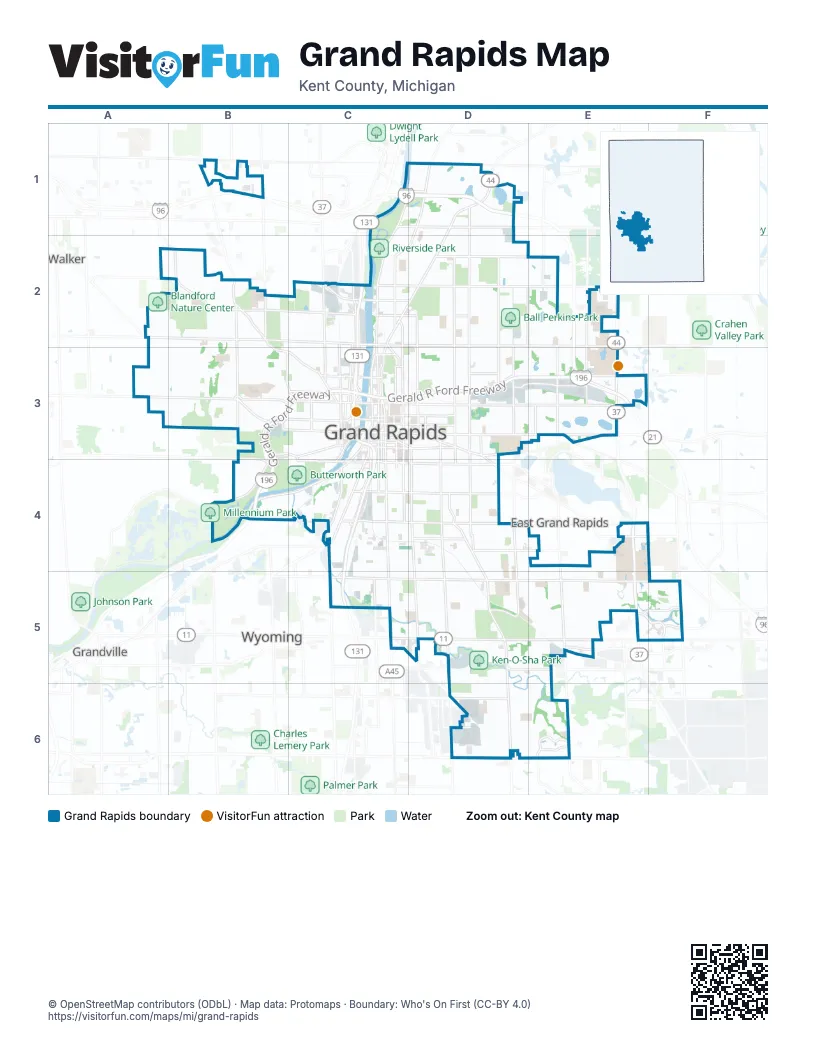
Street index of Grand Rapids
Each street on the sheet and the grid squares it crosses.
- Gerald R Ford FreewayB3, C3, D3, E3, B4
- East Beltline Avenue NortheastE2, E3
- Lake Michigan Drive NorthwestA3, B3, C3
- 28th Street SoutheastC5, D5, E5, F5
- Fulton Street EastC3, D3, E3
- Division Avenue SouthC3, C4, C5
- East Beltline Avenue SoutheastE4, E5
- Plainfield Avenue NortheastD1, C2, D2, C3
- 44th Street SoutheastD6, E6
- Fulton Street WestB3, C3
- Division Avenue NorthC3
- Broadmoor Avenue SoutheastE5
- Kalamazoo Avenue SoutheastD4, D5, D6
- Burton Street SoutheastC5, D5, E5, F5
- Eastern Avenue SoutheastD3, D4, D5, D6
- Michigan Street NortheastC3, D3, E3
- Fuller Avenue NortheastD1, D2, D3
- Leonard Street NorthwestA2, B2, C2
- Leonard Street NortheastC2, D2, E2
- Knapp Street NortheastC2, D2, E2
- Coit Avenue NortheastD1, C2, D2, C3
- Monroe Avenue NorthwestC2, C3
- Alger Street SoutheastC5, D5, E5
- College Avenue NortheastD1, D2, D3
- Breton Avenue SoutheastE4, E5, E6
- Market Avenue SouthwestC3, B4, C4
- Hall Street SoutheastC4, D4
- Fuller Avenue SoutheastD3, D4, D5, D6
- Walker Avenue NorthwestB1, B2, B3, C3
- 7th Street NorthwestB3, C3
- Bridge Street NorthwestB3, C3
- Wealthy Street SoutheastC4, D4
- Turner Avenue NorthwestC2, C3
- Century Avenue SouthwestC4, C5
- Plymouth Avenue SoutheastD3, D4, D5, D6
- 3 Mile Road NortheastC1, D1
- Lake Drive SoutheastD3, D4, E4
- Cesar E Chavez Avenue SouthwestC3, C4
- Martin Luther King Jr. Street SoutheastC4, D4
- Scribner Avenue NorthwestC2, C3
- Alpine Avenue NorthwestC2, C3
- Plymouth Avenue NortheastD2, D3
- Leffingwell Avenue NortheastE2, E3
- Hall Street SouthwestC4
- Wealthy Street SouthwestC4
- Ottawa Avenue NorthwestC3
- Monroe Avenue NortheastC1, D1, C2
- Godfrey Avenue SouthwestC4
- Ann Street NorthwestC2
- Robinson Road SoutheastD3, E3
- Garfield Avenue SouthwestC3, C4
- Burton Street SouthwestC5
- 4 Mile Road NortheastD1
- North Park Street NortheastC1, D1
- Hynes Avenue SouthwestC4
- 29th Street SoutheastE5
- Clyde Park Avenue SouthwestC4, C5
- Martin Luther King Jr. Street SouthwestC4
- East Paris Avenue SoutheastF5
- Dean Lake Avenue NortheastE2
- Stocking Avenue NorthwestC3
- Sheridan Avenue SouthwestC4
- Pearl Street NorthwestC3
- 4 Mile Road NorthwestB1
- Ann Street NortheastC2, D2
- Cherry Street SouthwestC3
- Sparks Drive SoutheastF5
- Michigan Street NorthwestC3
- Cascade Road SoutheastE3
- Coldbrook Street NorthwestC3
- Hall Street US 131 CutoffC4
- Bridge Center Street NorthwestB3
- Chicago Drive SouthwestC4
- Ann Street ConnectorC2
- Madison Avenue SoutheastD3, D4, D5
- Richmond Street NorthwestA2, B2, C2
- Diamond Avenue NortheastD2, D3
- Jefferson Avenue SoutheastC3, C4, C5
- Lafayette Avenue NortheastC1, C2, C3
- Bristol Avenue NorthwestB1, B2, B3
- Butterworth Street SouthwestB3, C3, B4
- Ball Avenue NortheastD2, D3
- Lafayette Avenue SoutheastC3, C4, C5, D5
- Lyon Street NortheastC3, D3
- Buchanan Avenue SouthwestC4, C5
- Covell Avenue NorthwestB2, B3
- Oakleigh Avenue NorthwestB2, B3
- Adams Street SoutheastD4, E4
- Bradford Street NortheastC3, D3, E3
- Aberdeen Street NortheastD2, E2
- Eastcastle Drive SoutheastE6
- Valley Avenue NorthwestB2, B3, C3
- Union Avenue NortheastD1, D2, D3
- Broadway Avenue NorthwestC2, C3
- Dickinson Street SoutheastC4, D4
- Ionia Avenue SouthwestC3, C4, C5
- Fountain Street NortheastC3, D3
- Boston Street SoutheastD4, E4
- Maryland Avenue NortheastE2, E3
- Oak Industrial Drive NortheastD3, E3
- 6th Street NorthwestB3, C3
- Seward Avenue NorthwestC2, C3
- Sweet Street NortheastC2, D2
- Lake Eastbrook Boulevard SoutheastE5, F5
- Cherry Street SoutheastC3, D3
- Ionia Avenue NorthwestC2, C3
- Perkins Avenue NortheastE2, D3, E3
- 2nd Street NorthwestC3
- Sinclair Avenue NortheastD1, D2, D3
- 3rd Street NorthwestC3
- 1st Street NorthwestC3
- 32nd Street SoutheastD5, E5
- O'Brien Road SouthwestB3, B4
- 36th Street SoutheastD6
- Clancy Avenue NortheastC2, C3
- Watson Street SouthwestC3
- Coldbrook Street NortheastC3, D3
- Oakdale Street SoutheastD4
- Lane Avenue NorthwestC3
- Camelot Drive SoutheastE5, F5
- Matilda Street NortheastC3, D3
- Lakeside Drive NortheastE3
- Diamond Avenue SoutheastD3, D4
- Carlton Avenue SoutheastD3, D4
- Elmridge Drive NorthwestB2
- Hastings Street NortheastC3, D3
- Mount Vernon Avenue NorthwestC3
- 43rd Street SoutheastE6
- Winter Avenue NorthwestC3
- Commerce Avenue SouthwestC3, C4
- Covell Avenue SouthwestB3
- Front Avenue SouthwestC3, C4
- Ransom Avenue NortheastC3
- Oakes Street SouthwestC3
- Lyon Street NorthwestC3
- Service Road NED3
- Bostwick Avenue NortheastC3
- State Street SoutheastC3, D3
- 40th Street SoutheastD6
- Seward Street NorthwestC2, C3
- Newberry Street NorthwestC3
- Weston Street SouthwestC3
- Weston Street SoutheastC3
- Oakes Street SoutheastC3
- Lexington Avenue SouthwestC3
- Library Street NortheastC3
- Ellsworth Avenue SouthwestC3, C4
- Seward Avenue SouthwestC3
- Lakeside Drive SoutheastE3
- Fountain Street NorthwestC3
- Winter Avenue SouthwestC3
- 2nd StreetC3
- Sweet Street NorthwestC2
- Knapp Street NorthwestC2
- East Park Place NortheastC3
- Fuller Lake CutoffD3
- Union Avenue SoutheastD3, D4, D5
- Giddings Avenue SoutheastD4, D5, D6
- Griggs Street SoutheastC4, D4, E4
- College Avenue SoutheastD3, D4, D5
- Eastern Avenue NortheastD1, D2, D3
- Houseman Avenue NortheastD2, D3
- 4th Street NorthwestB3, C3
- Prospect Avenue SoutheastC3, D3, C4, D4, D5
- Paris Avenue SoutheastD3, D4, D5
- Emerald Avenue NortheastD2, D3
- Garfield Avenue NorthwestC2, C3
- Chamberlain Avenue SoutheastD4, E5, E6
- Logan Street SoutheastC4, D4
- Elliott Street SoutheastD5, E5
- Benjamin Avenue SoutheastD3, D4
- Carlton Avenue NortheastD1, D2, D3
- Spencer Street NortheastC2, D2
- Sibley Street NorthwestB3, C3
- Fremont Avenue NorthwestC2, C3
- Ardmore Street SoutheastD4, D5, E5
- Blaine Avenue SoutheastD4, D5
- Collindale Avenue NorthwestB2, B3
- Knollcrest CircleE4, E5
- Pine Avenue NorthwestC2, C3
- Tamarack Avenue NorthwestC2, C3
- Crescent Street NortheastC3, D3
- Benjamin Avenue NortheastD1, D2, D3
- Front Avenue NorthwestC2, C3
- Prospect Avenue NortheastC2, C3, D3
- Myrtle Street NorthwestB2, C2
- Rosewood Avenue SoutheastD3, D4, D5, D6
- Thomas Street SoutheastD4
- Mayfield Avenue NortheastD1, D2, D3
- Crosby Street NorthwestB2, C2
- Burke Avenue NortheastD2, D3
- Worcester Drive NortheastE2, E3
- Cass Avenue SoutheastC4
- Calvin Avenue SoutheastD4, D5
- Alexander Street SoutheastD4
- Graceland Street NortheastC2, D2
- Paris Avenue NortheastD1, D2, D3
- Sherman Street SoutheastD4
- Oakwood Avenue NortheastD1, C2, D2
- Spring Avenue NortheastD1, D2, D3
- 11th Street NorthwestB3, C3
- Powers Avenue NorthwestC2, C3
- Woodlawn Avenue SoutheastE4, E5
- Webster Street NorthwestB2, C2
- Carpenter Avenue NorthwestB2, B3
- Elmdale Street NortheastD1
- Cottage Grove Street SoutheastC4, D4
- McReynolds Avenue NorthwestC2, C3
- Alto Avenue SoutheastD4, D5
- Marshall Avenue SoutheastD4, D5
- Woodcliff Avenue SoutheastE4, E5
- Davis Avenue NorthwestC2, C3
- Cambridge Drive SoutheastD4, D5
- Sylvan Avenue SoutheastD4, D5
- Grand Avenue NortheastD3
- Godwin Avenue SoutheastD4, D5
- Mulford Drive SoutheastD5, E5
- Kent ISD DriveE2
- Horton Avenue SoutheastC4, C5
- Mason Street NortheastD3, E3
- Steele Avenue SouthwestC4, C5
- Tremont Boulevard NorthwestB3
- Okemos Drive SoutheastE5
- Fairfield Avenue NorthwestB2, B3
- Jennette Avenue NorthwestC2, C3
- Northridge Drive NorthwestB1
- Francis Avenue SoutheastC4, C5
- Nelson Avenue SoutheastD4, D5
- Maynard Avenue NorthwestA3
- Muskegon Avenue NorthwestC2, C3
- North Avenue NortheastD2, D3
- Philadelphia Avenue SoutheastD4, D5
- Prince Street SoutheastD4
- Griswold Street SoutheastC5, D5
- Ridgewood Avenue SoutheastE4, E5
- 5th Street NorthwestC3
- Foster Avenue NortheastD1, D2
- 10th Street NorthwestA3, B3, C3
- Orville Street SoutheastD4, E4
- Evergreen Street SoutheastD4, E4
- Bates Street SoutheastD4
- Lincoln Avenue NorthwestC2, C3
- Hamilton Avenue NorthwestC2, C3
- Park Street SouthwestB3, C3
- Eleanor Street NortheastC2, D2
- Burritt Street NorthwestA3, B3
- Henry Avenue SoutheastD3, D4
- Cedar Street NortheastC3, D3
- Worden Street SoutheastD4
- Delaware Street SoutheastC4, D4
- Brooklyn Avenue SoutheastD5, D6
- Cornerstone College Drive NortheastE3
- Charlotte Avenue NorthwestB2, B3
- Sheldon Avenue SoutheastC4
- Parkhurst Avenue NorthwestB2, B3
- Millbrook Street SoutheastE5, D6, E6
- Widdicomb Avenue NorthwestC2, C3
- Lafayette Alley SoutheastC4
- Millbank Street SoutheastE5, D6, E6
- Linden Avenue SoutheastD4, D5
- Hoyt Street SoutheastD5
- Page Street NortheastC2, D2
- Sligh Boulevard NortheastC1, C2, D2
- Herrick Avenue NortheastD2
- Cass Alley SoutheastC4
- Dunham Street SoutheastD4
- Neland Avenue SoutheastD4
- Bemis Street SoutheastD4
- Sigsbee Street SoutheastD4
- Kirtland Street SouthwestC5
- Marsh Ridge Drive NorthwestA3, B3
- Veto Street NorthwestC3
- California Street NorthwestC3
- Cheney Avenue NortheastD1
- Steelcase Drive SoutheastD6
- Innes Street NortheastD3
- Edgewood Avenue SoutheastE4, E5
- Lagrave Avenue SoutheastC3, C4
- Pleasant Street SoutheastC4, D4
- Poinsettia Avenue SoutheastD5, D6
- Camelot Court SoutheastF5
- Oakhurst Avenue NorthwestB3
- Griggs Street SouthwestC4
- Russwood Street NortheastC1, D1
- Fisk Road SoutheastD4
- Quarry Avenue NorthwestC2, C3
- Horton Alley SoutheastC4, C5
- Hollywood Street NortheastD2
- Dean Street NortheastC2, D2
- Lamberton Street NortheastC1, D1
- Watkins Street SoutheastD4
- Arianna Street NorthwestB2, C2
- Beechwood Street NortheastD2
- Cutler Street SouthwestC5
- Saginaw Road SoutheastD5, E5
- Kentridge Drive SoutheastD6, E6
- Edna Street SoutheastD5
- Dawes Avenue SoutheastD5, D6
- Jackson Street NorthwestC3
- 8th Street NorthwestB3, C3
Things to do on the Grand Rapids map
Places on the map
- Aberdeen Park
- Acrisure Amphitheater
- Ah-Nab-Awen Park
- Ball Perkins Park
- Berkley Hills
- Butterworth Park
- Calvin University
- Celebration Village
- Centerpointe Mall
- Church Lake
- Fair Plains Cemetery
- Grand Rapids Bike Park
- Grand Rapids Home For Veterans
- Greenwood Cemetery
- Holy Cross Cemetery
- Huff Park
- Indian Trails Golf Course
- Ken-O-Sha Park
- Kent Country Club
- Kent County Jail
- Knapp's Corner
- Knapp's Crossing
- Lake Eastbrook
- Lamberton Lake
- MacKay-Jaycee Park
- Mid Lake
- Millennium Park
- Mines Golf Course
- New Community Church
- Oak Hill Cemetery
- Plaster Creek
- Plaster Creek Family Park
- Richmond Park
- Riverside Park
- St. John's Home
- The Highlands
- Underground Loop (MTB)
- Union High School
- West Catholic High School
- Woodlawn Cemetery
Next to Grand Rapids
- East Grand Rapids
- Grandville
- Walker
- Wyoming map
© OpenStreetMap contributors, Open Database License, openstreetmap.org/copyright · Map data: Protomaps · Boundary: Who's On First (CC-BY 4.0); U.S. Census Bureau