

Michigan road map
I-69 in Michigan map
I-69 is about 196 miles in Michigan. It has 64 exits, from Exit 3 at mile 3 to Exit 199 at mile 195. It meets 21 highways; US 27, I-94 and US 12 meet it in the most grid squares.
Open the map (PDF, US Letter)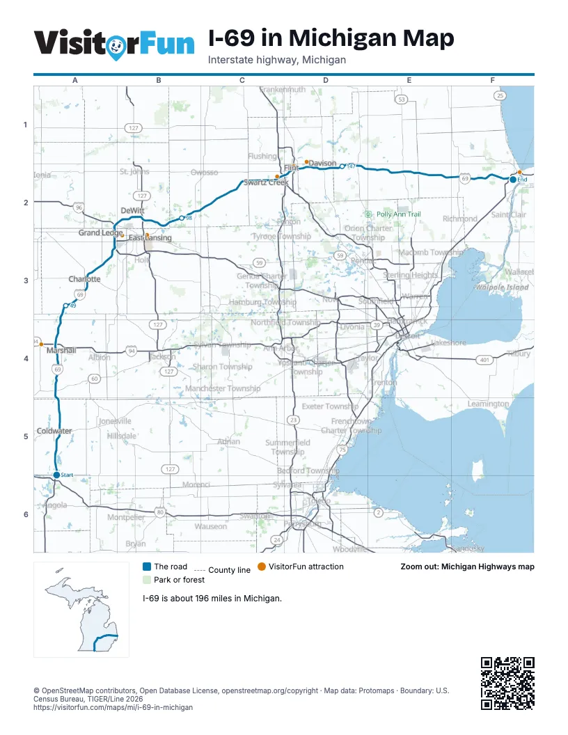
Exits on I-69 in Michigan
Each exit in mile order, with its grid square.
- Exit 3mile 3, A5
- Exit 10mile 9, A5
- Exit 13mile 13, A5
- Exit 16mile 15, A5
- Exit 23mile 22, A5
- Exit 25mile 25, A4
- Exit 32mile 31, A4
- Exit 36mile 35, A4
- Exit 38mile 38, A4
- Exit 42mile 42, A4
- Exit 48mile 47, A3
- Exit 51mile 50, A3
- Exit 57mile 56, A3
- Exit 60mile 59, A3
- Exit 61mile 60, A3
- Exit 66mile 66, A3
- Exit 70mile 69, A3
- Exit 72mile 71, A3
- Exit 97mile 72, A3
- Exit 95mile 74, A2
- Exit 93Bmile 75, A2
- Exit 93Amile 75, A2
- Exit 91mile 77, A2
- Exit 81mile 79, B2
- Exit 84mile 81, B2
- Exit 85mile 83, B2
- Exit 87mile 84, B2
- Exit 89A-Bmile 86, B2
- Exit 89B-Amile 87, B2
- Exit 92mile 90, B2
- Exit 94mile 93, B2
- Exit 98mile 95, B2
- Exit 105mile 103, B2
- Exit 113mile 110, C2
- Exit 118mile 115, C2
- Exit 123mile 120, C2
- Exit 128mile 125, C2
- Exit 129mile 126, C2
- Exit 131mile 128, C2
- Exit 133mile 129, C2
- Exit 117Bmile 130, C2
- Exit 135mile 131, D2
- Exit 136mile 133, D2
- Exit 137mile 133, D2
- Exit 7mile 133, D2
- Exit 138mile 134, D2
- Exit 139mile 136, D2
- Exit 141mile 137, D2
- Exit 143mile 140, D2
- Exit 145mile 141, D2
- Exit 149mile 145, D2
- Exit 153mile 150, D2
- Exit 155mile 152, D2
- Exit 159mile 156, E2
- Exit 163mile 159, E2
- Exit 168mile 164, E2
- Exit 176mile 172, E2
- Exit 180mile 176, E2
- Exit 184mile 180, F2
- Exit 189mile 185, F2
- Exit 194mile 189, F2
- Exit 196mile 192, F2
- Exit 198mile 194, F2
- Exit 199mile 195, F2
Highways I-69 meets
Each highway it meets and the grid squares where they meet.
- US 27A5, B2
- US 12A5
- MI 60A4
- I-94A4, F2
- MI 78A3
- MI 50A3
- MI 100A3
- I-96A3
- MI 43A2
- US 127B2
- MI 52B2
- MI 71C2
- MI 13C2
- I-75C2
- US 23C2
- I-475D2
- MI 54D2
- MI 15D2
- MI 24D2
- MI 53E2
- MI 19F2
Towns along I-69 in Michigan
In mile order, with the grid square of each.
- Coldwatermile 11, A5
- Tekonshamile 23, A4
- Marshallmile 33, A4
- Olivetmile 48, A3
- Charlottemile 58, A3
- Pottervillemile 65, A3
- Lansingmile 71, A3
- Waverlymile 73, A3
- Wacoustamile 78, A2
- DeWittmile 83, B2
- East Lansingmile 88, B2
- Bathmile 88, B2
- Haslettmile 92, B2
- Perrymile 100, B2
- Morricemile 103, B2
- Vernonmile 114, C2
- Durandmile 115, C2
- Lennonmile 119, C2
- Swartz Creekmile 123, C2
- Flintmile 128, C2
- Burtonmile 135, D2
- Davisonmile 141, D2
- Lapeermile 149, D2
- Atticamile 159, E2
- Imlay Citymile 164, E2
- Capacmile 172, E2
- Emmettmile 180, F2
- Port Huronmile 196, F2
Things to do on the I-69 in Michigan map
© OpenStreetMap contributors, Open Database License, openstreetmap.org/copyright · Map data: Protomaps · Boundary: U.S. Census Bureau, TIGER/Line 2026