

Michigan map
Kalamazoo County map
About 264,780 people live here (Census Bureau, 2024 estimate). The sheet's index lists 57 streets; Sprinkle Road, East W Avenue and M 89 cross the most grid squares. Things to do inside the boundary: Kalamazoo.
Open the map (PDF, US Letter)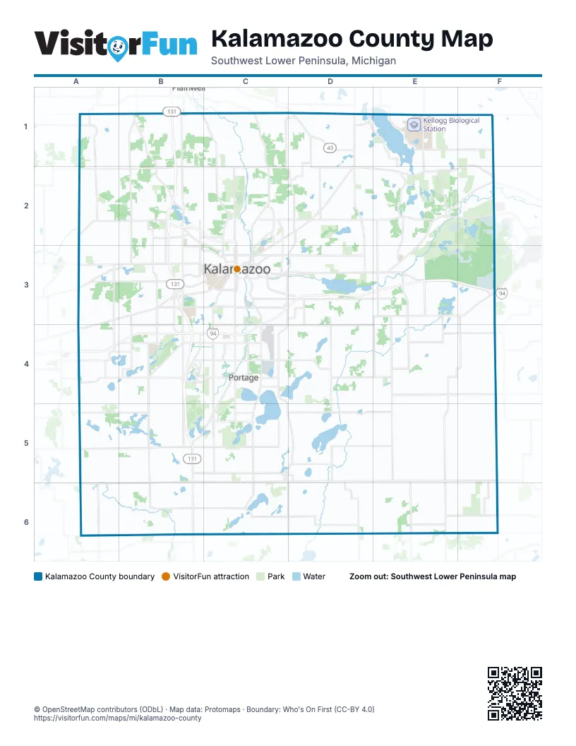
Street index of Kalamazoo County
Each street on the sheet and the grid squares it crosses.
- Douglas AvenueC1, C2, C3
- East AB AvenueD1
- East C AvenueD1
- East Richplain DriveD1
- North 32nd StreetD1, D2
- South M-43 HighwayD1
- West Gull Lake DriveD1
- M 89F1, D2, E2, F2
- West D AvenueA2, B2
- BUS US-131B2, C2
- Gull RoadC2, D2, C3
- East D AvenueD2
- Sprinkle RoadD2, C3, D3, C4, C5, D5
- Dickman RoadE2, F2
- East Augusta DriveE2, E3
- East Michigan AvenueE2, C3, D3, E3
- West Michigan AvenueE2, C3, E3
- M-89F2
- Stadium DriveA3, B3, C3, A4
- West Main StreetA3, B3, C3
- South 9th StreetB3, B4
- Amvets Memorial HighwayC3, D3
- East Cork StreetC3
- East Kalamazoo AvenueC3
- King HighwayC3, D3
- Michikal StreetC3
- North Park StreetC3
- North Pitcher StreetC3
- North Westnedge AvenueC3
- Oakland DriveC3, C4
- Portage RoadC3, C4
- Portage StreetC3
- Riverview DriveC3
- South Park StreetC3
- South Pitcher StreetC3
- South Westnedge AvenueC3, C4
- Southtown StreetC3
- West Kalamazoo AvenueC3
- Business Spur I-94D3
- East Battle Creek StreetE3
- Red Arrow HighwayA4
- I-94B4
- US-131B4, B6
- West Centre AvenueB4, C4
- East Centre AvenueC4
- Shaver RoadC4, B5, C5
- East Eliza StreetB5
- North Grand StreetB5
- South Grand StreetB5, B6
- West W AvenueB5, C5, C6
- East Highway StreetC5, D5
- East Prairie StreetC5
- East W AvenueC5, D5, E5, F5, C6
- North Richardson StreetC5, D5
- South Kalamazoo AvenueC5
- West Highway StreetC5
- East V AvenueD5
Things to do on the Kalamazoo County map
Places on the map
- 58 West
- 6th Street Park
- Aggregate Resources
- Air Zoo
- Al Sabo Land Preserve
- Alamo Rest Area 709
- Alamo Township
- Alamo Township Park
- Alen Edwin Plate
- Angels Crossing Golf Course
- Anna's Vineyard Apartments
- Antenna Field
- Arthur and Mildred Woollam Nature Preserve
- Asylum Lake
- Atwater Millpond
- Augusta
- Augusta Creek State Fish and Wildlife Area
- Augusta Floodplain Nature Preserve
- Austin Lake
- Barton Lake
- Bass Lake
- Beacon Kalamazoo
- Bishop's Bog
- Black Lake
- Bonnie Castle Lake
- Bow in the Clouds Preserve
- Brady Township
- Brewer Woods Nature Sanctuary
- Briarwood Valley Condominiums
- Bronson Methodist Hospital
- Buckham Highlands
- Butterfield Lake
- Campbell Lake
- Campus Court at Knollwood
- Candlewyck Apartments
- Celery Flats North
- Charleston Township
- Chipman Preserve
- Climax
- Climax Township
Next to Kalamazoo County
- Plainwell
© OpenStreetMap contributors (ODbL) · Map data: Protomaps · Boundary: Who's On First (CC-BY 4.0)