

Michigan map
Marquette County map
About 67,979 people live here (Census Bureau, 2024 estimate). The sheet's index lists 300 streets; County Road, US-41 and County Road 550 cross the most grid squares. Things to do inside the boundary: Ellwood A. Mattson Lower Harbor Park, Lakenenland and Marquette Maritime Museum.
Open the map (PDF, US Letter)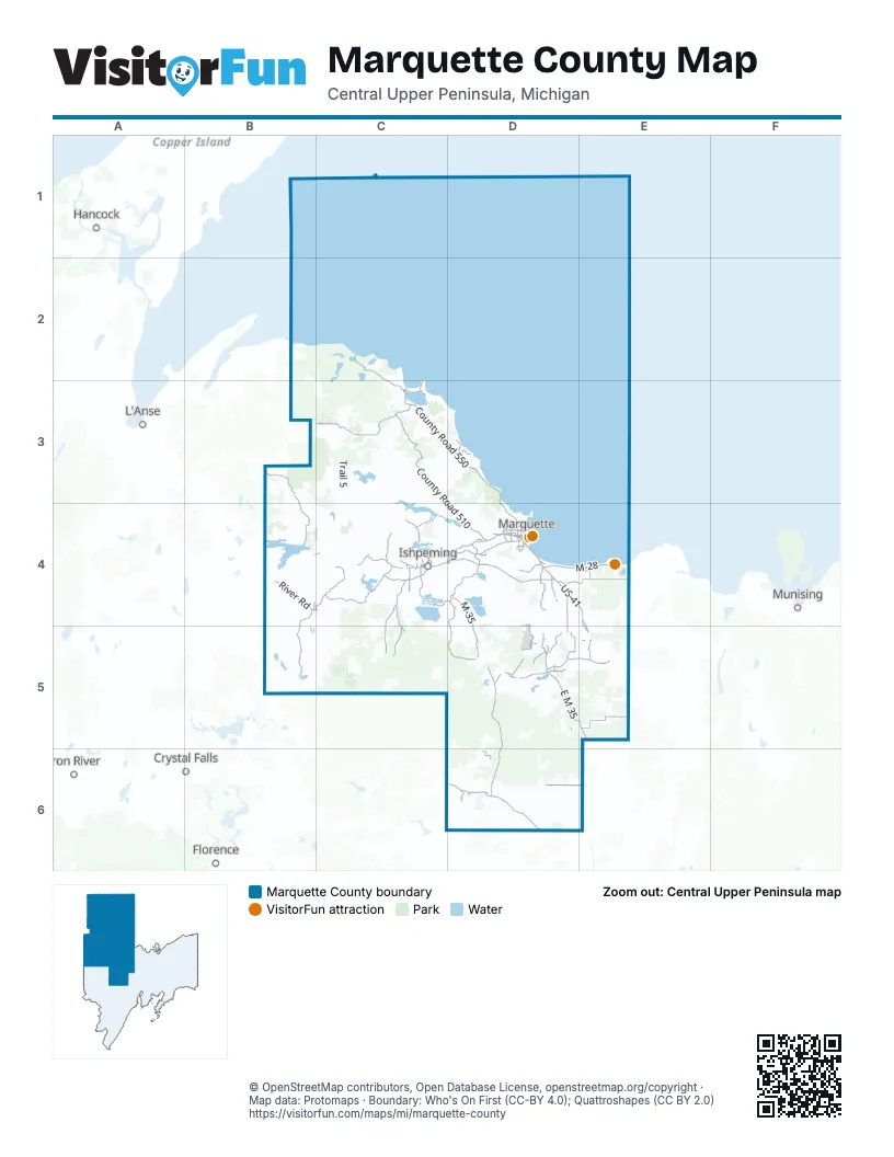
Street index of Marquette County
Each street on the sheet and the grid squares it crosses.
- M-35D4, D5
- East M 35D5, E5
- County Road 480D4
- M-28D4, E4
- US-41D4, E4, E5
- US-41/M-28D4
- Cherry Creek RoadD4
- County Road 492D4
- Marquette BypassD4
- South Front StreetD4
- West Washington StreetD4, D5
- South McClellan AvenueD4
- Division StreetD4
- North Pine StreetC4, D5
- North 2nd StreetC4
- Brickyard RoadD4
- West Main StreetB4, D4
- US Highway 41D4
- Lakeshore DriveC4
- North 4th StreetC4, D4
- West Iron StreetD5
- Palms AvenueC4
- Leif Erickson Memorial HighwayB5
- Forest DriveD4
- County Road HQD4
- Rail StreetD4
- Snyder StreetD4
- North Teal Lake AvenueD4
- North Lakeshore DriveC4
- East Stephenson AvenueD5
- M553D4
- South Pioneer AvenueD4
- County Road 510C3, D4
- County Road 550C3, D3, D4
- Triple A RoadC3
- Little Lake RoadD4, D5, E5
- Wright StreetD4
- Maas StreetD4
- South Carlshend RoadE5
- Midway DriveD4
- West Fair AvenueD4
- County RoadC4, D4, D5, D6
- Avenue AD5
- East Division StreetC4
- Presque Isle AvenueD4
- Grove StreetD4
- West Grove StreetD4
- Jackson StreetC4, D4
- West Division StreetC4
- North McClellan AvenueD4
- Silver StreetC4, D4
- Sugarloaf AvenueD4
- McClellan AvenueD4
- Bensinger StreetC3
- Big Bay RoadC3
- North Silver StreetD4
- County Road 557D5, D6
- County Road 601B4, C4, B5
- County Road 426C6, D6
- Huron Bay GradeB3, B4
- County Road 581C4, C5
- County Road 565D4, D5
- Mangum RoadD4, E4
- Huron Mountain Club RoadC2, C3
- County Road CgC4, C5
- Deer Lake RoadC4
- County Road 444E5
- County Road 476C4, D4
- Diorite RoadC4
- River RoadB4
- Black River RoadC4
- County Road 545 NorthD4, D5
- North Camp RoadC4, D6
- Greenwood Reservoir RoadC4
- West Maple Ridge 37th RoadD6, E6
- County Road 545D5
- North Greenwood RoadC4
- Engman Lake RoadD5
- Dam RoadC3
- Silver Creek RoadD4
- Kelly Johnson Memorial DriveD4, D5
- Stoneville RoadC4
- North Southgate DriveD5
- Greenwood Mine RoadC4
- Loma Farms RoadD3
- Saux Head Lake RoadD3
- Sporley Lake RoadD5
- Lakeshore BoulevardD4
- North Carlshend RoadE5
- Martin Lake RoadD5
- Kawbawgam RoadE4
- Ski Hill RoadD5
- Pioneer RoadD4
- Sporley Lake DriveD5
- Heritage DriveD4
- Pine StreetC4, D4, B5
- North 3rd StreetC4, D4
- Kreiger DriveE4, E5
- West Ridge StreetC4, D4
- North Westwood DriveC4
- Wawonowin Club RoadC4
- Washington StreetC4
- Sand River DriveE4
- Missouri RoadD4
- Lighthouse RoadC2, C3
- North 7th StreetC4, D4
- West Baraga AvenueD4
- Lincoln AvenueC4, D4
- Main StreetB4, C4, D4
- South Pine StreetC4
- Wilson Lake RoadD5
- North Serenity DriveD5
- East Main StreetB4, D4
- Park City RoadB4
- Werner StreetD4
- Altamont StreetD4
- Greenwood StreetC4
- Hawk DriveB4
- West College AvenueD4
- 5th StreetC4, D5
- Brookton RoadD4
- Croix StreetD4
- Saginaw StreetC4
- North Lake DriveC4
- North Front StreetD4
- Commerce DriveD4
- Ontario AvenueD4
- East Ridge StreetC4, D4
- Avenue DD5
- South Vandenboom RoadD4
- Avenue CD5
- Baldwin AvenueD4
- South Lakeshore BoulevardD4
- Elizabeth C Harden Circle DriveD4
- North Washington StreetC4
- Farmer Lake DriveD5
- Hawley StreetD4
- Randall DriveC4
- Fisher StreetD4
- East Lakeshore BoulevardD4
- East Empire StreetC4
- South 4th StreetC4, D4
- North Wilson Lake DriveD5
- Schenk StreetC3
- South Mesnard StreetB4
- South North Lake DriveC4
- Cooper Lake CutacrossC4
- South 7th StreetC4, D4
- Deer Lake AvenueC4
- South 3rd StreetC4, D4
- Iron StreetC4, D4, D5
- Kloman AvenueB4, C4
- Genesee StreetD4
- Hematite DriveC4
- West Railroad StreetB4
- East Fair AvenueD4
- West Euclid StreetC4
- North Main StreetC4
- Holme RoadE5
- Champion StreetD4
- Meeske AvenueD4
- Raymen StreetC3
- Avenue BD5
- South Main StreetC4
- 7th StreetC4, D4, D5
- Canda StreetC4
- Fourth StreetC4
- Tracy AvenueD4
- Brown AvenueD4
- Balke AvenueC3
- Deutsch AvenueC3
- Boney Falls H RoadD6
- South Healy AvenueD4
- Barnum StreetB4, C4
- North Max StreetB4
- Hosptial DriveD4
- Serenity DriveD5
- Hospital DriveD4
- East Washington StreetD4
- County Road EacD5
- East Baraga AvenueD4
- North Lakeshore BoulevardD4
- Euclid StreetC4
- Northwestern RoadB3, C3, D5
- Trail 5C3, C4
- Little West RoadD5, D6
- Cci Mine RoadC4, D4
- Dishno RoadB4, C4
- Wolf Lake RoadC4
- Hemmings Lake RoadC5, D5
- Red RoadC3, B4, C4
- Ford River RoadD6
- Stack GradeD5, E5
- Maple Grove RoadE5
- Flat Rock RoadC5
- County Road 438D5
- County Road FFC4, C5
- Old Triple A RoadC3
- Yalmer RoadE4
- Bryan Creek RoadC5
- Chain of Lakes RoadB5, C5
- Forestville RoadD3, D4
- County Road SMD6
- Escanaba River RoadD6
- Iron Pin TrailD5
- West Crooked Lake LaneD5
- Gold Mine RoadC3, D3
- Ford RoadB3, C3, D4
- County Road SID6
- Kate's GradeC5, D5
- Voelker Lake RoadC4, C5
- Fence River RoadB5
- Perrin Bros RoadD5
- Holli Blue RoadB4
- Pohlman DriveD5
- Camp Nine RoadD6, E6
- Blind 35C3
- North RoadC4, D4
- Tilden Mine Access RoadC4, D4
- Perrin Brothers TrailD5
- County Road LDB5
- Lakewood LaneD4
- County Road NpaD4
- Navaids Access RoadD5
- County Road AaoC3, C4
- Haul RoadD4
- County Road NNSD4, D5
- County Road NNRD4, D5
- Wildcat Creek RoadC3
- Parker SpurD5
- South Camp RoadC4
- County Road LjB5
- County Road NnuD4
- Valley RoadC4, D4
- North Basin DriveC4, D4
- Dalton RoadE4
- Squaw Lake RoadB5
- Leighton RoadD6
- County Road FFGC5
- Selma RoadE5
- County Road EexD5
- County Road RMD5, E5
- Anderson RoadD4, E4
- County Road CCEC4, C5
- County Road CwC5
- County Road LgaB4
- Charlie Lakes RoadC5, D5
- Grant Lake RoadB5
- Marshall DriveD5
- Miller Creek RoadD5
- County Road NNPD4
- Plantation LaneD6
- Chain Lake TrailD5
- Hamilton Homestead RoadD5, E5, D6
- South Rice Lake DriveD5
- County Road CCOC4
- Bob's Creek Truck TrailD5
- Miller RoadD4
- Cardinal Point RoadB4
- County Road SAD6
- Holly RoadD6, E6
- County Road CHC4
- Station RoadD4, D5
- Silver Lake RoadC3
- Airport RoadD4, D6, E6
- Charlie Lakes TrailD5
- North River DriveD5
- County Road RAE5
- County Road CCNC4
- County Road SHD6
- Dukes RoadE5
- Remington's RoadC3
- Lawson RoadE5
- Swanzy Lake RoadD5
- South Shag Lake DriveD5
- Hills RoadD5, E5
- Eagles Nest RoadD3
- Homestead RoadD6
- Setter DriveD5
- Tower Truck TrailC5
- County Road CCFC5
- County Road LLLB4, B5
- County Road SKD6
- County Road CLC4
- Sullivan Creek RoadC2, C3
- Town Hall RoadD4, E4, D5
- Floodwood RoadC5
- Camp 10 RoadC5, D5
- Island Lake RoadC4
- County Road PpzC5
- County Road CDC4
- Cooper Lake RoadC4
- 18 RoadB4, B5
- County Road 462D5
- Center StreetC4, D4, D5
- County Road SAAD6
- Ives Lake RoadC2, C3
- County Road CczC5
- Three Mile RoadC4, D4
- Road to Superior Game Ranch HQD6
Things to do on the Marquette County map
Places on the map
- Anderson Lake
- Anne and Cameron Waterman Preserve
- Bass Lake
- Bat Lake
- Bear Lake
- Big Bass Lake
- Big Bay
- Big Mud Lake
- Boney Falls Basin
- Boston Lake
- Brocky Lake
- Bulldog Lake
- Bullhead Lake
- Bush Lake
- Buto Lake
- Casey Lake
- Cataract Basin
- Chabeneau Lake
- Chain Lakes
- Champion Township
- Charley Lakes
- Chief Lake
- Chocolay Township
- Claus Camp Club
- Cliff Lake
- Cliff Lake Club
- Conway Lake
- Dukes Experimental Forest
- Escanaba River State Forest - Gwinn Unit
- Escanaba River State Forest - Gwinn Unit (North)
- Escanaba River State Forest - Gwinn Unit (South)
- Heartwood Forestland
- Huron Islands Unit
- Huron Mountain Club
- Huron National Wildlife Refuge
- Marquette County Forest
- Marquette Underwater Preserve
- Marquette Unit
- Michigan North Woods Club
- Mulligan Creek Highlands Reserve
Next to Marquette County
- Crystal Falls
- Florence
- Hancock
- Iron River
- L'Anse
- Munising
© OpenStreetMap contributors, Open Database License, openstreetmap.org/copyright · Map data: Protomaps · Boundary: Who's On First (CC-BY 4.0); Quattroshapes (CC BY 2.0)