

Minnesota map
Apple Valley map
About 55,272 people live here (Census Bureau, 2024 estimate). The sheet's index lists 300 streets; Cedar Avenue, 140th Street West and County Road 42 cross the most grid squares. Things to do inside the boundary: Minnesota Zoo.
Open the map (PDF, US Letter)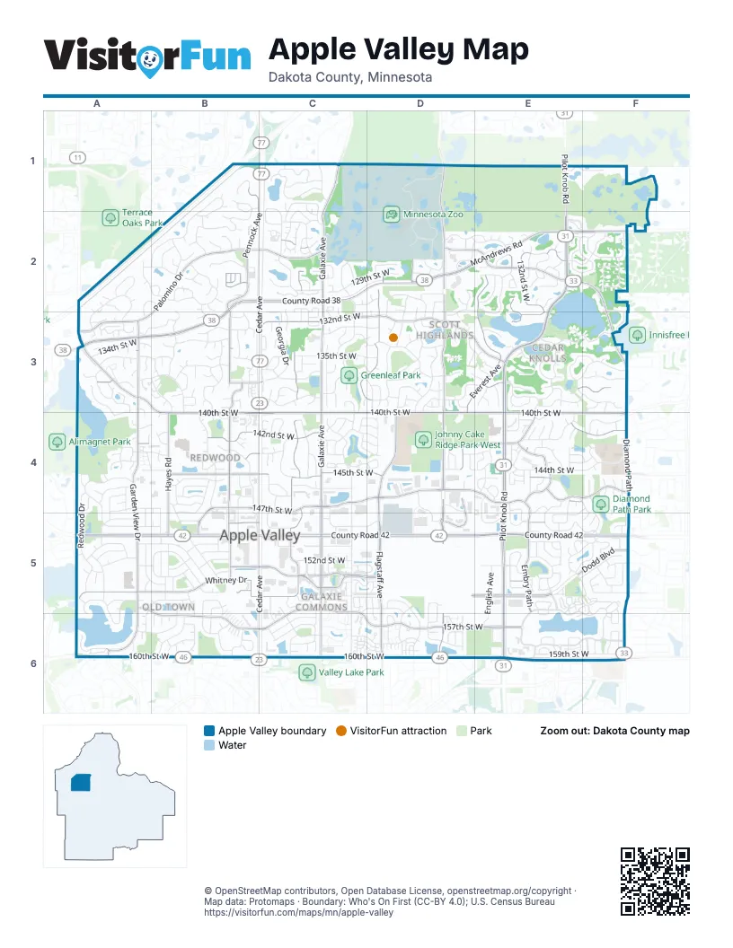
Street index of Apple Valley
Each street on the sheet and the grid squares it crosses.
- Cedar AvenueC1, B2, C2, B3, C3, C4, B5, C5, B6, C6
- County Road 42A5, B5, C5, D5, E5, F5
- Pilot Knob RoadE1, E2, E3, E4, E5, E6
- 160th Street WestA6, B6, C6, D6, E6, F6
- McAndrews RoadD2, E2, F2, A3, B3
- County Road 38B2, C2, D2
- McAndrews Road WestB2, B3
- East 138th StreetA3
- 140th Street WestA3, B3, B4, C4, D4, E4, F4
- Galaxie AvenueC1, C2, C3, C4, C5, C6
- Diamond PathE2, F2, F3, F4, F5, F6
- Johnny Cake Ridge RoadD1, D2, D3, D4, D5, D6
- Flagstaff AvenueD2, C3, D3, D4, D5, D6
- Pennock AvenueB1, B2, B3, B4, B5
- 157th Street WestA5, C5, B6, C6, D6, E6
- 147th Street WestB4, C4, D4, E4, F4, B5
- Garden View DriveA3, A4, A5, A6
- 132nd Street WestE2, C3, D3, E3
- Garrett AvenueC2, C3, C4, C5
- 142nd Street WestA4, B4, C4, D4, E4, F4
- Embry PathE4, E5
- 145th Street WestB4, C4, D4, E4, F4
- Palomino DriveB2, C2, A3, B3
- Whitney DriveA5, B5
- Everest AvenueE2, D3, E3, D4, D5
- Upper 147th Street WestD4, E4
- 153rd Street WestB5, C5, E5
- Hayes RoadB4, B5
- 155th Street WestC5, E5, F5
- 138th Street WestA3, B3, C3, E3, F3
- 127th Street WestC2, E2
- Ellice TrailD3, E3
- 149th Street WestB5, C5, D5, E5
- 126th Street WestC2, D2, E2
- 157th StreetC5, C6, D6
- 155th StreetD5, E5
- Founders LaneC5
- Essex AvenueE2, E4
- 153rd StreetC5, D5
- Dodd BoulevardE5, F5
- Pennock LaneB5
- Zoo BoulevardD2
- Highview AvenueA6
- Foliage AvenueC2, C3, C4, C5, C6
- 134th Street WestA3, B3, C3, D3, E3
- Cobblestone Lake ParkwayE5, F5, E6, F6
- 144th Street WestA4, B4, D4, E4, F4
- Cobblestone Lake Parkway SouthE6, F6
- 137th Street WestA3, B3, D3, F3, B4
- 158th Street WestC6, D6, E6
- 135th Street WestA3, B3, C3, D3
- Fernando AvenueD2, D3, D4, D5
- 133rd Street WestA3, B3, C3, D3
- Walnut LaneA4, A5, B5
- 159th Street WestB6, C6, E6, F6
- 131st Street WestB2, C2, D2, E2, D3
- 150th Street WestA5, B5
- 143rd Street WestA4, B4, C4, D4, E4, F4
- Guthrie AvenueB4
- Findlay AvenueD2, D3
- Duluth DriveE3, F3
- Cimarron RoadB1, B2
- Gantry LaneC1
- 152nd Street WestC5, E5, F5
- Chaparral DriveB1, A2, B2
- Granada AvenueB3, B4, B5, B6
- Redwood DriveA4, A5
- Dundee AvenueE4, F4, E5, F5
- Garland AvenueC2, C4
- Echo WayE4, E5, F5
- 129th Street WestB2, C2, D2, F2
- Harmony WayB3, B5, B6
- Highview DriveA5, A6
- Eagle Bay WayE5
- Glazier AvenueC4, C5
- 128th Street WestB2, C2, E2, F2
- Guild AvenueB3, B4
- Elkwood DriveE3
- Geneva WayC1, C2, C3
- Oriole DriveA5, B5
- Germane AvenueC2, C4
- Hunters WayA2, A3
- Glenda DriveB4, B5
- 146th Street WestB4, C4
- Finch AvenueD5, D6
- 141st Street WestB4, E4, F4
- Dover DriveF2
- Flora WayC4, D4
- 125th Street WestC2, D2, E2
- English AvenueE5, E6
- Strese LaneA4, B4, B5
- 158th StreetC6, D6, F6
- Euclid AvenueE2, E3, E4
- Essex TrailE3, E4
- Genesee AvenueC2, C4
- Cortland DriveB5
- Flagstone TrailC4, D4
- Fordham AvenueC3
- 151st Street WestC5, E5
- Georgia DriveC3
- Ferris AvenueD3
- 142nd Path WestE4
- Hayes TrailB5, A6, B6
- Florence TrailC4, C5, D5
- 130th Street WestC2, D2
- Heywood WayA5, B5, A6
- Findlay WayD2, D3
- Upper 136th Street WestC3
- Upper 145th Street WestB4
- Hunters CourtA2, A3
- Harwell PathB3
- Upper 139th Street WestC3
- Dorchester TrailE2, F2
- East Frontage RoadC3
- Emory AvenueE5
- Havelock TrailB3
- Drexel WayF5
- Garrett DriveC5, C6
- Dresden TrailF5
- Elm DriveA5
- Lowell DriveA5
- Eagle Bay DriveE5
- Hallmark DriveB4, B5
- Eveleth AvenueE2, D4
- Redwell LaneA5, B5
- Harwell AvenueB6
- Baldwin DriveA5, B5
- Dublin RoadE3, F3
- Emerald WayE4
- Highwood WayA2
- Dominica WayE3, F3
- Upper 146th Street WestB4, C4
- 133rd Street CourtB2, B3, D3, E3
- McIntosh DriveB5
- Fairlawn AvenueC3
- Fawn Ridge WayD3, D4
- Fleetwood AvenueC3, D3, D4
- Echo LaneE2
- Fjord AvenueD5, D6
- Hopewell LaneA5
- Dunbar CourtE4, F4, F5
- Ebony LaneE4
- Flower WayC5, D5
- Upper 157th Street WestC6
- Dunbar WayE3, F3
- Europa AvenueE4
- Embry WayE3
- Hallmark WayB5, B6
- Hamlet AvenueB2
- 148th Path WestE4, F4, E5
- Energy WayE4, E5
- Flintwood WayC4, D4
- Easter AvenueE4, E5
- Driftwood LaneE2, F2, F3, F4
- Huntington DriveA3
- Cortland Drive SouthB5
- 139th Street WestD3, E3
- 156th Street WestD5, D6
- Endicott WayE4, E5
- Freeport TrailC4
- 148th Street WestD4, E4, E5
- Holyoke PathA3, A4
- Haven DriveB4, B5
- Gabella StreetC5
- Falcon DriveD2
- 154th Street WestC5, D5, E5
- Safari PassC1
- Griffon PathB6
- Pinewood DriveA4
- Everest TrailD2, E2
- Gossamer WayB3
- 123rd Street WestC1, C2
- Herald WayA3, B3, B4
- Dominica Way WestE3, F3
- Hialeah PathA2, B2
- Holyoke LaneA3
- Eveleth PathD2, E2
- Hyland Pointe CourtA6
- Flackwood WayD6
- Reflection RoadA3, A4
- 120th Street WestE1, F1
- Durham WayE2, F2
- 144th Street CourtA4, C4
- Newell DriveB5
- Flight WayC5, D5
- 121st Street WestC1
- Essex WayE2
- Spruce DriveA4, A5
- Sweetwater DriveB2
- Florist CircleC5, D5
- Belmont RoadA2, B2
- Hidden Meadow RoadB1, B2
- Dupont PathE5, F5
- Garvin Brook LaneC2
- Flute WayC6
- Holland AvenueA4
- Excelsior LaneD4, E4
- Herald CircleB2
- Footbridge WayC4, D4
- Everglade AvenueD6
- District Office DriveF4
- Granada DriveB4
- Hallmark PathB5, B6
- Finch WayD2, D3
- Drawstone TrailF6
- Ember WayE3
- Dunwood TrailF5
- Fireside DriveB5
- Gladiola WayC3
- Evermore ParkwayF2, F3
- Fairfield DriveD5, D6
- Haralson DriveB5
- 134th Street CourtA3, D3
- 149th CourtF5
- Flackwood TrailD6
- Hickory WayA4
- Garrett PathC6
- Gooseberry WayB6
- Duchess LaneB5
- Heywood CourtA3, A5, B5, A6
- Hanover LaneB4
- Eddy Creek WayE5
- Dutton LaneF6
- Duck Pond WayF5, F6
- Dunberry WayF5, F6
- Ely AvenueE5
- Garnet AvenueC2, C3
- Ramsdell DriveA5
- Evergreen TrailE4
- Dunbar BoulevardE5, F5
- Frost Point WayC2
- Dory AvenueF2
- Hanover WayB3
- Early Bird CircleE5
- Folkstone RoadC6
- Eastbend WayE6, F6
- Surrey Trail SouthB1, B2
- 151st StreetC5
- Edinborough WayE2
- Granada WayB3
- Elkhart RoadE3
- Heritage WayA2, B2, A3
- Lower 147th Street WestB4
- Palomino Drive SouthB2
- 137th CourtA3, B3, C3, D3
- Genesee WayC1, C2
- Fleet TrailC6, D6
- Gamma WayC2, C3
- Downey TrailF2, F3
- Florida LaneD2
- Jonathan DriveB5
- Fridley WayC4
- Glenbrook WayC2
- Eveleth WayD3, E3
- Germane TrailC1, C2
- Denmark AvenueF2
- Guthrie WayB4
- Hannover PathB6
- Foxtail LaneC4
- Granite AvenueB4
- Elmhurst LaneE6
- Farmington WayD3
- Falcon Ridge TrailD2
- Shoshoni TrailB2
- Gallivant LaneC5
- Gavotte AvenueC2
- Hershey CourtA3, B6
- Garner WayC2
- Dutchman WayE5, F5
- Gaslight LaneC5, C6
- Ely PathE5
- Huntington TerraceA3
- Denmark CourtF4
- Garnet WayC5
- Fairchild WayD5, D6
- Gateway PathC5
- Flax WayD4
- Grandview TerraceB1
- Everton AvenueD2, D3, E3
- Fostoria DriveC5, C6
- Gannon WayC4
- Minjon DriveB5
- Glasgow LaneC3
- Elmwood WayE6
- Flotilla TrailC6, D6
- Fortino StreetC5
- Beacon LaneB5
- Fordham CourtC2, C3
- Glen WayB2
- 148th CourtF4, F5
- Dory CourtF4
- Drake PathF4
- 146th WayC4
- Embassy AvenueE4
- Fair Hill WayD6
- 132nd WayD3
- Duck Trail LaneF5
- Hollybrook DriveA3
- Lower Endicott WayE4, E5
- Rimrock DriveA4
Things to do on the Apple Valley map
Places on the map
- Amur Tiger
- Apple Grove Park
- Apple Valley Business Campus
- Apple Valley High School
- Augustana
- Bison
- Carrington Park
- Carrollwood Park
- Cedar Isle Park
- Cobblestone Lake
- Delaney Park
- Diamond Path Park
- Embry Path Park
- Faith Park
- Farquar Lake
- Farquar Lake Park
- Fedex / Kinkos
- Findlay Park
- Fischer Sand and Aggrate
- Galaxie Park
- Galaxie Park Lake
- Greenleaf Park
- Greenleaf Woods
- Hagemeister Park
- Huntington Park
- Johnny Cake Ridge Park East
- Johnny Cake Ridge Park West
- Lac Lavon
- Lac Lavon Park
- Lebanon Cemetery
- Long Lake
- Long Lake Park
- Longridge Park
- Menards
- Minnesota Zoo
- Moeller Park
- Summerfield Park
- Treetop Trail
- Valleywood Golf Course
- Wheaton Pond
© OpenStreetMap contributors, Open Database License, openstreetmap.org/copyright · Map data: Protomaps · Boundary: Who's On First (CC-BY 4.0); U.S. Census Bureau















