

Minnesota map
Bemidji Township map
About 15,733 people live here (Census Bureau, 2024 estimate). The sheet's index lists 151 streets; Paul Bunyan Expressway, Carr Lake Road Southwest and Van Buren Avenue Southeast cross the most grid squares. Also on it: Lake Marquette, Beltrami County Demolition Landfill and Carr Lake.
Open the map (PDF, US Letter)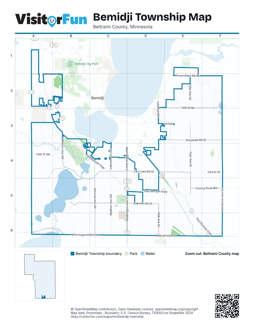
Street index of Bemidji Township
Each street on the sheet and the grid squares it crosses.
- Adams Avenue NorthwestA1, A2
- Butterfly Drive NorthwestA1
- Clover Court NorthwestA1
- Fox Drive NorthwestA1
- Rynders Court NorthwestA1
- Snowmass Drive NorthwestA1
- Braman Drive NortheastE1, E2
- Brinkman Drive NortheastE1, E2
- 15th Street NorthwestA2
- Arrowwood Circle NorthwestA2
- Branch Court NorthwestA2
- Bush Court NorthwestA2
- Dirk Lane NorthwestA2
- Division Street WestA2
- Gerald Lane NorthwestA2
- Jefferson Avenue NorthwestA2, B2
- Johnson Street NorthwestA2
- Paul Bunyan ExpresswayA2, A3, B3, B4, C4, C5, D5, E5, E6, F6
- Renee Court NorthwestA2
- Betty Way NorthwestB2
- Gregg Court NorthwestB2
- Ross Lane NorthwestB2
- Augusta Drive NortheastE2
- Briar Lane NortheastE2
- Camelot Drive NortheastE2
- Doral Drive NortheastE2
- Grotte Avenue NortheastE2
- Mill Street NortheastE2, F2
- Power Dam Road NortheastE2
- Saint Onge Drive NortheastE2
- Tyler Avenue NortheastE2, E3
- Valley View DriveE2
- Canoe Lane NortheastF2
- Starlight Lane NortheastF2
- Van Buren Avenue SoutheastF2, F3, F4, F5, F6
- 15th Street SouthwestA3, B3
- Simone Drive SouthwestA3
- Thomas Road SouthwestA3, B3
- Timberlane Way SouthwestA3
- Towering Pines Court SouthwestA3
- Jefferson Avenue SouthwestB3, B4
- Kalee Court SothwestB3
- Lincoln Log Lane SouthwestB3, B4
- Lynn Marie Court SouthwestB3
- Mag Seven Court SouthwestB3
- Mikrantip Road SouthwestB3
- Richie Court SoutheastB3
- Richie Court SouthwestB3
- Yellowhead Road SouthwestB3, B4
- 1st Street EastD3, E3
- 3rd Street NortheastD3, E3
- 3rd Street SoutheastD3, E3
- 5th Street NortheastD3, E3
- Chesapeake Drive SouthD3, E3, D4
- Doberman Court SoutheastD3
- Lake Avenue NortheastD3
- Acorn Lane NortheastE3
- Hovet Drive SoutheastE3
- Little Norway Avenue SoutheastE3, E4
- Meadow Court NortheastE3
- Merle Court NortheastE3
- Roosevelt Road SoutheastE3, F3
- Tyler Avenue SoutheastE3, E4, E5
- 16th Street SouthwestA4, B4
- Carr Lake Road SouthwestA4, B4, C4, A5, B5, C5
- Double C RoadA4
- River Island Lane SouthwestA4
- Buzzkill Lane SouthwestB4
- Canopy Lane SouthwestB4
- Carved Woodduck Lane SouthwestB4
- County Highway 11B4
- Dow Court SouthwestB4
- Holland Road SouthwestB4
- Kingston Lane SouthwestB4
- Lassie Lane SouthwestB4, C4
- Monroe Avenue SouthwestB4, C4, C5, C6
- Otterpoint Lane SouthwestB4
- Pleasant Court SouthwestB4
- Rivercrest Lane SouthwestB4
- Zana Lane SouthwestB4
- 18th Street SouthwestC4
- Carr Lake Road SoutheastC4, D4, E4
- Chapel Lane SouthwestC4
- Lakeview Drive SouthwestC4
- Madison Avenue SouthwestC4, C5, C6
- Pine Grove Street SouthwestC4
- Shedhorn Street SouthwestC4
- Washington Avenue SouthC4, C5, D5, C6, D6
- Francis Court SoutheastD4, E4
- Miles Avenue SoutheastD4
- Paul Bunyan Drive SoutheastD4, E5
- Stoner Avenue SoutheastD4
- 23rd Street SoutheastE4, F4
- Edgewood Drive SoutheastE4
- Fjordes Court SoutheastE4
- Forest Lane SoutheastE4
- Lundar Drive SoutheastE4
- Maplewood Drive SoutheastE4
- Marion Drive SoutheastE4
- Open Meadows Court SoutheastE4
- Ventura Drive SoutheastE4
- Woodland Hills Drive SoutheastE4, E5
- Bray Burn Lane SouthwestA5
- Buchanan Avenue SouthwestA5
- Harmony Trail SouthwestA5
- Hawthorne Lane SouthwestA5
- Highland Southwest DriveA5
- La Terra Lane SouthwestA5, B5
- Prairie View Court SouthwestA5
- Sawyer Road SouthwestA5
- Cottage Lane SouthwestB5
- Fellowship Court SouthwestB5
- Firetrail Lane SouthwestB5
- Jackson Avenue SouthwestB5
- Manor Court SouthwestB5
- Mission Field Road SouthwestB5
- Norrona Court SouthwestB5
- Oak Hills Road SouthwestB5, C5
- Southcamp Road SouthwestB5, B6
- Southgate Lane SouthwestB5
- Woodridge Lane SouthwestB5
- Anitas Way SouthwestC5
- Bentley Drive SouthwestC5
- Convenience Lane SouthwestC5, D5
- Irenes Way SouthwestC5
- Margos Way SouthwestC5
- Oak Hills Road SoutheastC5, D5
- Peaceful Meadow Lane SoutheastC5, D5
- Woodward Drive SouthwestC5
- 30th Street SoutheastD5, F5
- Convenience Lane SoutheastD5
- Fenske Farm Lane SoutheastD5
- Kaymar Court SoutheastD5
- Polk Avenue SoutheastD5, D6
- County Road 404E5, F5
- Lynx Road SoutheastF5
- 209th AvenueA6
- North Plantagenet Road SouthwestA6, B6, C6
- Old Schoolcraft Court SouthwestA6, B6
- Yaubetcha Lain SouthwestA6, B6
- Bull Elk Court SouthwestB6
- 229th AvenueC6
- Beltrami Line RoadD6, E6, F6
- Animal Land DriveE6
- Graycalm Court SoutheastE6, F6
- Union RoadE6
- County 36F6
- County Road 45F6
- North Grace Lake Road SoutheastF6
- Woodberry Court SoutheastF6
- Woodberry Drive SoutheastF6
Places on the map
- Adult Day Services Inc
- Arco
- Beltrami County Demolition Landfill
- Bemidji Baptist Church
- Bemidji Slough Wildlife Management Area
- Boreal Forest
- Calvary Lutheran Church
- Canine Divine
- Carr Lake
- Carters Collision
- Cenex
- Cloverleaf-East Bemidji Airport
- CrossFit
- Evangelical Free Church of Bemidji
- Horace May Elementary
- Lake Marquette
- Ley's Painting, Inc.
- Meyers Auto Services
- Poor Farm Cemetery
- Ridge Top Outdoors
- Royal Oaks RV Park
- RP Broadcasting
- Safe Stow
- Silver Maple Campsite
- Suzy & Hondo School of Dance
- The Old Schoolhouse
- Wagner Plumbing & Heating
Next to Bemidji Township
© OpenStreetMap contributors, Open Database License, openstreetmap.org/copyright · Map data: Protomaps · Boundary: U.S. Census Bureau, TIGER/Line Shapefiles 2024















