

Minnesota map
Brainerd map
About 14,400 people live here (Census Bureau, 2024 estimate). The sheet's index lists 261 streets; Riverside Drive, South 10th Street and Wright Street cross the most grid squares. Also on it: Rice Lake, Boom Lake and Brainerd High School.
Open the map (PDF, US Letter)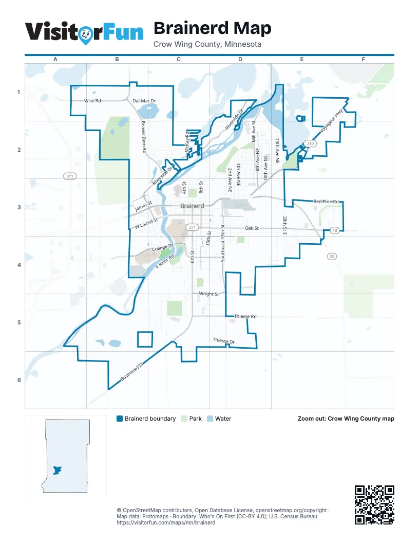
Street index of Brainerd
Each street on the sheet and the grid squares it crosses.
- Wise RoadA1, B1
- Beaver Dam RoadB1, B2, C2
- Dal-Mar DriveB1, C1
- Serene Pines CourtB1
- Sugarberry Creek RoadB1
- Del-Mar CircleC1
- Ahrens Hill RoadD1
- Ashmun RoadD1
- County Road 3D1
- Island DriveD1, D2
- Lakeview LaneD1, D2
- Mill Avenue NorthD1, D2
- Old Stonebridge CourtD1
- Old Stonebridge TrailD1
- Riverside DriveD1, C2, D2, B3, C3
- Sunset WayD1, D2
- Easy StreetE1
- Jordan RoadF1
- Pepperidge RoadF1
- Voyageur HighwayF1, E2
- Coles WayB2
- Bluff AvenueC2, D2, C3
- Boom CourtC2
- Clearview LaneC2
- Highview CircleC2
- McKay RoadC2
- North 8th StreetC2, C3
- North 9th StreetC2, C3
- Northtown StreetC2
- Old Court WayC2
- Rice CourtC2
- Russell RoadC2
- Twins StreetC2
- Viking StreetC2
- Warrior AvenueC2
- Westridge CircleC2
- Wild AvenueC2
- Wolves StreetC2
- 10th Avenue NortheastD2, D3
- 11th Avenue NortheastD2
- 1st Avenue NortheastD2, D3
- 2nd Avenue NortheastD2, D3
- 3rd Avenue NortheastD2, D3
- 4th Avenue NortheastD2, D3
- 5th Avenue NortheastD2, D3
- 6th Avenue NortheastD2, D3
- 7th Avenue NortheastD2, D3
- 8th Avenue NortheastD2, D3
- 9th Avenue NortheastD2, D3
- Evergreen AvenueD2, D3
- F Street NortheastD2
- G Street NortheastD2, E2
- H Street NortheastD2, E2
- I Street NortheastD2, E2
- J Street NortheastD2, E2
- K Street NortheastD2, E2
- L Street NortheastD2, E2
- League AvenueD2, D3
- M Street NortheastD2, E2
- N Street NortheastD2, E2
- North 10th StreetD2, D3
- North 11th StreetD2, D3
- O Street NortheastD2, E2
- P Street NortheastD2
- Q Street NortheastD2
- 12th Avenue NortheastE2
- 13th Avenue NortheastE2
- 14th Avenue NortheastE2
- 15th Avenue NortheastE2
- 32nd StreetE2
- J StreetE2
- M StreetE2
- Northeast Washington StreetE2, D3
- Pine Shores RoadE2
- Rice Lake LaneE2
- Wonderland Park RoadE2
- Woodland Park CircleE2
- Charles StreetB3, C3
- Circle Pines CourtB3
- Circle Pines DriveB3
- Clay StreetB3
- Cora StreetB3, C3
- Ethel StreetB3, C3
- Excelsior Road NorthB3
- Highland Scenic Drive SouthB3, B4
- Jackson StreetB3
- James StreetB3, C3
- Northwest 3rd StreetB3, C3
- Northwest 4th StreetB3, C3
- Northwest 5th StreetB3, C3
- Northwest 6th StreetB3
- Northwest 7th StreetB3
- Northwest 8th StreetB3
- Northwest 9th StreetB3
- Southwest 6th StreetB3, C3, C4
- Southwest 7th StreetB3
- Southwest 8th StreetB3, B4
- Southwest 9th StreetB3
- West Laurel StreetB3, C3
- West Washington StreetB3, C3
- Chippewa StreetC3
- East River RoadC3, C4
- Fir StreetC3, D3
- Front StreetC3
- Grove StreetC3, D3
- Ivy StreetC3, D3
- Juniper StreetC3, D3
- Kingwood StreetC3, D3
- Laurel StreetC3, D3
- Maple StreetC3, D3
- May StreetC3
- North 1st StreetC3
- North 2nd StreetC3
- North 3rd StreetC3
- North 4th StreetC3
- North 5th StreetC3
- North 6th StreetC3
- North 7th StreetC3
- North Holly StreetC3, D3
- Northwest 2nd StreetC3
- Norwood StreetC3, D3
- Oak StreetC3, D3, E3
- Pine StreetC3, D3, E3
- South 10th StreetC3, D3, C4, D4, C5
- South 2nd StreetC3
- South 3rd StreetC3
- South 4th StreetC3, C4
- South 5th StreetC3, C4
- South 6th StreetC3, C4, C5
- South 7th StreetC3, C4, C5
- South 8th StreetC3, C4
- South 9th StreetC3, C4
- Southwest 3rd StreetC3
- Southwest 4th StreetC3, C4
- Southwest 5th StreetC3, C4
- Tyrol DriveC3
- Washington StreetC3, D3
- Williams StreetC3
- 11th Street SouthD3, D5
- 11th Street SoutheastD3, D4
- 14th Street SoutheastD3, D4
- B Street NortheastD3
- C Street NortheastD3
- D Street NortheastD3
- E Street NortheastD3
- Gillis AvenueD3
- Highway 25 SouthD3, E3
- Northern Pacific RoadD3
- Southeast 11th StreetD3
- Southeast 12th StreetD3, D4
- Southeast 13th StreetD3, D4, D5
- Southeast 15th StreetD3, D4
- Southeast 16th StreetD3, D4
- Southeast 17th StreetD3
- Southeast 18th StreetD3
- Southeast 19th StreetD3, D4
- Walnut StreetD3, D4
- 27th Street SoutheastE3
- 28th Street EastE3, E4
- Beech StreetE3, E4
- Birch StreetE3
- Division StreetE3
- Hotlton AvenueE3, E4
- King CourtE3, E4
- Oak LawnE3
- Red Pine RoadE3
- State AvenueE3
- State Highway 18E3, F3
- State Highway 25E3, E4
- Two Mile RoadF3
- Anabec StreetB4
- Carlos RoadB4
- Cindy StreetB4
- College RoadB4
- Greenwood Road SouthB4
- Katie LaneB4
- Minnesota DriveB4
- Mississippi ParkwayB4, C4
- West College DriveB4, C4
- 4th StreetC4
- 8th Street SouthC4
- Birchridge DriveC4, C5
- Brian LaneC4
- Broadway StreetC4
- Brook StreetC4, D4
- Cedar StreetC4
- Colonywood LaneC4
- East College DriveC4
- Emma StreetC4
- Graydon AvenueC4, C5
- Hattie StreetC4
- Hawkins DriveC4
- Jenny StreetC4
- Joseph StreetC4
- Lake StreetC4
- Lawn StreetC4, D4
- Linden LaneC4
- Mary StreetC4
- Park StreetC4
- Paul CircleC4
- Paul StreetC4
- Pennsylvania AvenueC4
- Quince StreetC4, D4
- Ronald StreetC4
- Rosewood StreetC4, D4
- Summit StreetC4, D4
- Sycamore StreetC4
- Tamarac StreetC4
- Todd StreetC4
- Vine StreetC4
- Willow StreetC4, D4
- Wood Crest RoadC4, C5
- Wright StreetC4, D4, C5, D5
- 12th Street SoutheastD4
- 16th StreetD4
- Chicago Avenue SoutheastD4
- Erick LaneD4
- Fred LaneD4, E4
- Hart RoadD4
- Jessica LaneD4
- Karie LaneD4
- Kay LaneD4
- Kelley Rae RoadD4
- Kermit LaneD4, E4
- Merri LaneD4
- Nikkohl RoadD4
- Portland AvenueD4
- St Louis AvenueD4
- 28th Street SoutheastE4
- Addison AvenueE4
- Blair CircleE4
- Blair StreetE4
- Clara StreetE4
- Oakridge RoadE4
- Shelly LaneE4
- York CourtE4
- Aspen CourtB5
- Buffalo Hills Lane WestB5, C5
- Mississippi DriveB5
- Ridge DriveB5, C5
- Andrew StreetC5, C6
- Belle Rae CircleC5
- Buffalo Hills Lane EastC5
- Business 371C5, B6, C6
- Carol LaneC5
- Crestview LaneC5
- Fairfield LaneC5
- Greenwood StreetC5
- Hillcrest DriveC5
- Industrial Park RoadC5, D5
- Madison StreetC5, D5
- Norway CourtC5
- Pine View DriveC5
- Ridge CourtC5
- Ridge Drive SouthC5
- Spruce DriveC5
- Tanager CircleC5
- Thiesse DriveC5, D5
- Woodland Hills LaneC5
- Woodridge LaneC5
- Thiesse RoadD5
Places on the map
- AutoZone
- Bane Park
- Beaver Pond
- Boom Lake
- Brainerd City Fire Department
- Brainerd City Hall
- Brainerd Credit Union
- Brainerd High School
- Brainerd Police Department
- Brainerd Post Office
- Brainerd Public Library
- Buffalo Hills Park
- Buffalo Lake
- Burger King
- Buster Dog Park
- Central Lakes College
- Crow Wing County Historical Society and Museum
- Crow Wing County Jail
- Crow Wing County Judicial Center
- Crow Wing County Sheriff's Office
- Cub Foods
- DQ Grill & Chill
- Essentia Health St Joseph's Medical Center
- Evergreen Cemetery
- Gregory Park
- Jackson Street
- Jaycees Park
- Kiwanis Park
- Lum Park
- McDonald's
- Mickey's Subs
- Mill Ave Park
- Northern Pacific Center
- Perkins
- Rice Lake
- Saint Andrew's Catholic Church
- St. Francis & All Saints
- St. Francis of the Lakes Catholic School
- Wells Fargo
- Wendy's
© OpenStreetMap contributors, Open Database License, openstreetmap.org/copyright · Map data: Protomaps · Boundary: Who's On First (CC-BY 4.0); U.S. Census Bureau















