

Minnesota map
Crow Wing County map
About 68,642 people live here (Census Bureau, 2024 estimate). The sheet's index lists 300 streets; 2nd Street, Voyageur Highway and State Highway 6 cross the most grid squares. Things to do inside the boundary: Paul Bunyan Land.
Open the map (PDF, US Letter)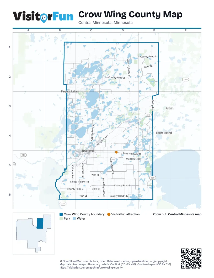
Maps inside Crow Wing County
1 map inside, from the street map of Crow Wing County down.
Street index of Crow Wing County
Each street on the sheet and the grid squares it crosses.
- Voyageur HighwayD3, E3, C4, D4, E4
- State Highway 25C5, C6
- State Highway 210B5, C5
- C. Elmer Anderson Memorial HighwayC5
- US Highway 169E5
- Business 371C5
- Old MN 371B2, B3
- Oak StreetD1, D4, C5
- Northeast Washington StreetC4, C5
- County Road 112B2
- South 6th StreetC5
- West Washington StreetC5
- Highway 25 SouthC4, C5
- Washington StreetC5, E5
- 4th StreetD4, C5
- 8th Avenue NortheastC4, C5
- East Main StreetD3
- Archibald RoadD3, D4
- West Main StreetD3
- East Front StreetD4, E4
- 3rd Avenue SouthwestD3, D4
- State Highway 6D1, D2, D3, E4, E5
- State Highway 18C5, D5, E5
- County Road 11C2, D2, D3
- County Road 12D4
- Main StreetB2, B3, D3, D4
- West Front StreetD4
- County Road 1C1, D1, E1, B2, C2
- County Road 2B6, C6, D6, E6
- County Road 3D1, C2, D2, C3, C4
- County Road 36C2, D2, E2
- County Road 8D5, D6, E6
- County Road 10E4, E5
- County Road 23D5, D6
- County Road 16B2, C2
- County Road 139C6, D6
- Nokay Lake RoadD4, D5
- Sleepy Hollow RoadB6, C6
- County Road 22C5, D5
- Red Pine DriveD2, C3, C4
- St Mathias RoadC5, C6
- Woodrow Road NortheastD4, D5
- County Road 105E2, E3
- Meadowview RoadD5, D6
- County Road 144C5
- County Road 15B2
- County Road 13B3, C3
- County Road 106E1, E2
- County Road 102D4
- County Road 26D5, E5
- County Road 66C1, C2
- County Road 127C4
- Wise RoadC4
- Thompson RoadC5, D5
- County Road 113D6
- County Road 136D1
- Crooked Lake RoadD4, E4, D5
- County Road 109C3, D3
- Highland Scenic Drive SouthB5, C5
- County Road 18B3, C3
- County Road 9C5, C6
- County Road 133E4
- County Road 39C2
- County Road 25C4, C5
- County Road 121C5, B6, C6
- County Road 111E3, E4
- Riverside DriveC4
- County Road 132D5
- County Road 103C2
- Tame Fish Lake RoadE4
- County Road 24D5
- County Road 145B2, C2
- County Road 137C3, C4
- Mapleton Road SouthB5, C5
- Clearwater Road NorthB4, C4
- County Road 130C6
- County Road 122C6
- County Road 107B3
- County Road 118C3
- County Road 44C5
- County Road 119C4
- Excelsior Road NorthC5
- Ojibwa Park Road NorthB4, C4
- Father Foley DriveC2
- Cuyuna RoadD3
- County Road 116C3
- Wilderness RoadB3
- County Road 104C5, D5
- Johnson RoadC4
- County Road 108D5
- College RoadC5
- 100th StreetC5
- Greenwood StreetC5
- County Road 125B4
- Pine Beach RoadB4, C4
- Southeast 13th StreetC5
- 12th Avenue SouthwestB1, B2
- Thiesse RoadC5
- County Road 138E5, E6
- Fawn Lake RoadC2
- County Road 77B3
- Woida Road NorthB4, C4
- Isle DriveC3, C5
- County Road 142C4
- Inglewood Drive NorthC4, C5
- Beaver Dam RoadC4
- Cypress DriveC4, C5
- West College DriveC5
- 9th Avenue SouthwestB2, B3
- County Road 114D2
- County Road 141E3
- County Road 168B3
- Front StreetB2, B3, C5, B6
- Nashway RoadB4, C4
- Pine Beach Road NorthwestB4
- County Road 34D3
- County Road 134C1, C2
- Airport RoadC3, C4
- State Park RoadB5
- County Road 28D4
- Green Gables Road NorthwestB4
- 2nd StreetD1, B2, C2, B3, D4, B5
- Laurel StreetC5
- Mill Avenue NorthC4
- South 8th StreetC5
- County Road 29B3
- Cannon Ball RoadE6
- County Road 149D6
- Old 371B2
- County Road 123C5
- Inglewood DriveC4
- Ojibwa RoadC4
- Glory Road SouthC5
- Quince StreetC5
- Irene AvenueD4
- County Road 43B1
- County Highway 17B2
- County Road 129D6
- 3rd Street SouthwestD4
- Northwest 4th StreetC4, C5
- County Road 143C5
- Jengeogh RoadD4
- County Road 37C2
- Douglas Fir DriveC5
- Willow StreetE4, C5
- West Laurel StreetC5
- Wright StreetC5
- Industrial Park RoadC5
- South 4th StreetC5
- Cypress Drive SouthC5
- Eagle StreetC2, E3
- Veterans StreetB2
- Lilac AvenueB2
- Ironwood Drive SouthC5
- County Road 135D3
- Nisswa AvenueB3
- County Highway 43B1
- Lakers LaneB3
- County Road 8 SoutheastD5
- Jackson StreetC4, C5
- Hinckley RoadC5
- South Main StreetB3
- Superior AvenueD4
- East College DriveC5
- Serpent Road EastD4, E4
- Quest RoadD6
- County Highway 51D6
- 44th Street SouthwestB2
- Minnesota AvenueD3
- Maple Road EastD4
- County Road 147D4
- 4th AvenueB2
- County Road 155 NortheastD1
- 132nd Street SouthwestB5
- 24th Street SouthwestB2
- 326th AvenueD6
- Gull Lake Dam RoadB4
- 460th StreetE6
- 205th AvenueC6
- County Road 17 SouthwestB2
- Interlachen RoadB3
- Jewel RoadC6
- 30th StreetC6, D6
- Mail Route RoadD5, E5
- 170th AvenueD5, D6
- 5 Mile RoadD4, D5
- Sunset Valley RoadC3
- North Nelson RoadD4
- Cooley DriveD6, E6
- Old Manganese RoadD3
- 50th Avenue SouthwestB5, B6
- Oxcart RoadE6
- Sorenson Lake RoadC4, D4
- 10th StreetB6, C6
- Old Grade RoadC1
- Olander RoadD2
- Lens RoadE2
- Wilderness Point RoadE5
- 20th StreetB6, C6
- Wetherbee RoadB5, C5, B6
- Kego Lake RoadC1, D1
- Leisure LaneD5
- Little Pine RoadE1
- County Road 56B1
- Spruce Grove RoadE3
- Brainerd International RacewayB4, C4
- North Koering RoadB5, B6
- Stewart Lake RoadC1
- Miller Lake RoadD3, E5
- Iron Hub RoadD3, E3
- Paddy AvenueE3
- Lawson RoadB6
- Ranchette DriveC2, C3
- West Shore DriveC2
- Moritz RoadD2
- Linden StreetD4, E5
- Oakridge RoadC5
- East Horseshoe Lake RoadC2, C3
- Rebel RoadC3, C4
- Executive Acres RoadC4
- Wood RoadD2, D3, D4
- Tower RoadD2, D4
- Bonnie Lakes RoadD2
- Fairview Road NorthB5, C5
- 70th StreetC5
- Old Mill RoadC3
- South Oakridge LaneC6
- Koering RoadB6
- Racine RoadC5, C6
- Woodland Beach RoadE4, E5
- River RoadB2, D3
- Red Pine RoadD2, C5
- Forest Knolls RoadC2
- Darsnek RoadD2
- Camp Lake RoadD5, E5, E6
- Legend LaneB5, B6
- Pelican Lake RoadC3
- Gardenview RoadC3
- Country LaneB3, C4, E4
- Cook RoadC5
- 123rd Street SouthwestB6
- Division RoadD5
- Cedar Lake DriveE3
- Pine StreetB2, D2, D4, C5
- Hay Creek RoadB6, C6
- Timber LaneC2, D5
- Meyer RoadB6
- Beach RoadC3, D4
- 210th AvenueD6
- Round Lake RoadC2, B4, E5
- Crooked RoadD4
- Burgwald RoadD5
- Swanburg RoadC1, C2
- Mill RoadD1, D5
- Bass Lake RoadD2, B3, C3
- Wild Acres RoadB2, C2
- Lower Roy Lake RoadB3
- Buschmann RoadC2
- Old Ramsey RoadC1, C2
- Town Hall RoadE3
- Wicklund RoadC5
- Nokay Hall RoadD4, D5
- 90th AvenueC6
- Manhattan Point BoulevardC2
- Birchdale RoadB4, C4
- Lower Dean Lake RoadE3
- Church RoadC5, C6
- East Clark Lake RoadC3
- South Black Bear RoadD3
- Mollie Lake RoadC3, C4
- Rider RoadD4
- Ruttger RoadC2
- Katrine DriveE4, E5
- Tamarack RoadD2
- Lennox RoadB5
- Ossawinnamakee RoadC2
- Nokasippi River RoadC6
- Bluegill RoadD4
- Bulldozed RoadB1
- Old Whiskey RoadC2
- Island Lake RoadD2, E2
- Buehler RoadC6
- Akerson RoadB2, C2
- 150th Avenue SoutheastD5, D6
- Linberg RoadE4
- Bedow RoadB6
- Butternut Road SoutheastC5
- Smith RoadC4
- Butterfield Beach RoadD1
- Three Mile RoadC5
- Big Pine TrailC2
- Daggett Hall RoadC6
- Narrow Lane RoadC5, D5
- Old Hwy 18C3, E5
- Barbeau RoadB4
- Mississippi Shores RoadB6
- Camp Lincoln RoadB3, B4
- West Eagle Lake RoadD1
- Middle Cullen RoadC3
- White Pine DriveC4, E4
Things to do on the Crow Wing County map
Places on the map
- Adney Lake
- Agate Lake
- Allen Lake
- Anna Lake
- Arbor Lake
- Arrowhead Lake
- Bass Lake
- Baxter
- Bay Lake
- Bay Lake Township
- Bertha Lake
- Big Bird Lake
- Big Trout Lake
- Birchdale Wildlife Management Area
- Black Bear Lake
- Black Hoof Lake
- Black Lake
- Blue Lake
- Bonnie Lake
- Borden Lake
- Brainerd
- Brainerd International Raceway
- Breezy Point
- Bulldog Lake
- Butterfield Lake
- Camp Lake
- Campbell Lake
- Carlson Lake
- Casey Lake
- Center Township
- Chrysler Lake
- Clamshell Lake
- Clark Lake
- Clear Lake
- Clearwater Lake
- Clinker Lake
- Clough Lake
- Crow Wing State Forest
- Crow Wing State Park
- Cuyuna Country State Recreation Area
Next to Crow Wing County
- Aitkin
- Farm Island
© OpenStreetMap contributors, Open Database License, openstreetmap.org/copyright · Map data: Protomaps · Boundary: Who's On First (CC-BY 4.0); Quattroshapes (CC BY 2.0)















