

Minnesota map
Duluth map
About 87,986 people live here (Census Bureau, 2024 estimate). The sheet's index lists 300 streets; West Skyline Parkway, East Superior Street and West 3rd Street cross the most grid squares. Things to do inside the boundary: Adventure Zone Duluth, Aerial Lift Bridge and Canal Park.
Open the map (PDF, US Letter)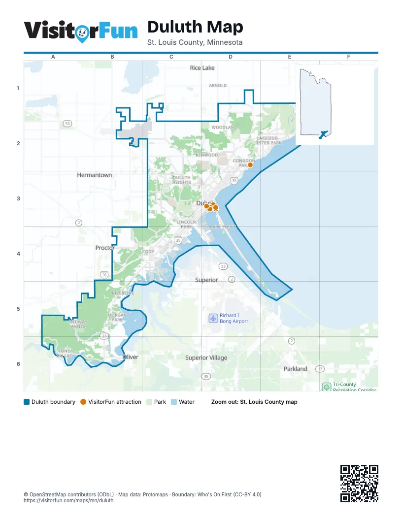
Street index of Duluth
Each street on the sheet and the grid squares it crosses.
- Garfield AvenueC3, C4, D4
- John A. Blatnik BridgeD4
- Bong Memorial BridgeC4
- I-35 SouthC3
- I-35 South Entrance Ramp From Superior StreetD3
- South 1st Avenue WestD3
- I-35 South Entrance Ramp From Mesaba AvenueD3
- Blue Star Memorial Highway/34th Infantry (Red Bull) Division HighwayD4
- East Superior StreetE1, F1, D2, E2, D3
- Grand AvenueB4, C4, B5
- Haines RoadC2, C3, C4
- West Arrowhead RoadC2, D2
- Rice Lake RoadC2, C3, D3
- London RoadD2, E2, D3
- Congdon BoulevardE1, F1, E2
- Woodland AvenueD1, D2, D3
- Piedmont AvenueC3
- West Michigan StreetC3, D3, C4
- West 3rd StreetC3, D3, C4, A6
- West Superior StreetC3, D3, C4
- Commonwealth AvenueB5, B6
- Trinity RoadC3
- Maple Grove RoadC2, C3
- Mesaba AvenueD3
- West 2nd StreetC3, D3, C4, A6
- Miller Trunk HighwayC2, C3
- Veterans' Evergreen Memorial DriveA6, B6
- Airport RoadB2, C2
- East Central EntranceC3, D3
- West Central EntranceC3
- South Arlington AvenueC3
- North Arlington AvenueC2, C3
- North Lake AvenueC3, D3
- North 1st Avenue WestD3
- North 21st Avenue EastD2, D3
- Carlton StreetC4
- South 21st Avenue EastD3
- North 4th Avenue WestC3, D3
- 2nd Avenue Exit RampD3
- Piedment AvenueC3
- Oldenberg ParkwayA6
- East Skyline ParkwayE1, D2, E2, D3
- East 4th StreetD2, D3
- West 1st StreetC3, D3, C4, A6
- Jean Duluth RoadD1, D2
- Becks RoadA5, B5, A6, B6
- East 3rd StreetD2, D3
- East 2nd StreetD2, D3
- Glenwood StreetD2, E2
- Martin RoadC1, D1
- Howard Gnesen RoadC2, D2
- Mall DriveC2, C3
- Anderson RoadC3
- Kenwood AvenueD2, D3
- Cody StreetB4, C4
- West College StreetD2
- North Central AvenueC4
- South Boundary AvenueB4
- North 6th Avenue EastD3
- Raleigh StreetB4, C4
- Getchell RoadB4
- Snively RoadD2
- Highland StreetB4, C4
- North 24th Avenue WestC3, C4
- North 27th Avenue WestC3, C4
- Morris Thomas RoadC3
- East McCuen StreetB6
- Observation RoadC3
- Waseca Industrial RoadC4
- Wallace AvenueD2
- North 10th Avenue EastD3
- North 12th Avenue EastD3
- North 46th Avenue WestC4
- Grinden DriveB2, C2
- North 40th Avenue WestC4
- East Buffalo StreetD2
- West Saint Marie StreetD2
- North Boundary AvenueB4
- Lower Michigan StreetC3
- Mike Colalillo DriveC4
- Central Entrance DriveD3
- North 11th Avenue WestC3
- Bristol StreetC4
- East Calvary RoadD2
- North 14th Avenue EastD3
- North 21st Avenue WestC3
- Junction AvenueD2
- North 10th Avenue WestC3
- South 27th Avenue WestC4
- South Central AvenueC4
- East Arrowhead RoadD2
- East Saint Marie StreetD2
- State Highway 39B6
- Lavaque RoadB4
- South 40th Avenue WestC4
- 2nd StreetB4
- 5th StreetB4
- South 14th Avenue EastD3
- Oliver BridgeB6
- South 21st Avenue WestC3
- South 12th Avenue EastD3
- Market StreetC2
- West Skyline ParkwayC3, D3, B4, C4, A5, B5
- Minnesota AvenueD3, D4
- West 4th StreetC3, D3, C4, A6
- West 5th StreetC3, D3, C4, A6
- East 1st StreetD2, D3
- West 6th StreetC3, D3, C4, A6
- Swan Lake RoadB2, C2, C3
- East 8th StreetD2, D3
- West 8th StreetC3, D3, C4, A6
- West 7th StreetC3, D3, C4, A6
- Lester River RoadE1, E2
- East 7th StreetD2, D3
- North 59th Avenue WestC4
- Decker RoadC3
- Chambersburg AvenueC3
- East 9th StreetD2, D3
- Vinland StreetB4
- Saint Louis River RoadB4
- South Lake AvenueD3
- Pleasant View RoadD1
- Lakewood RoadF1
- Port Terminal DriveD4
- Airpark BoulevardC2
- North 43rd Avenue EastE2
- North 47th Avenue EastE2
- West Railroad StreetC3, D3
- Oakley StreetE2
- North 45th Avenue EastE2
- North 52nd Avenue EastE2
- North Basswood AvenueC2, C3
- 88th Avenue WestB5
- Westgate BoulevardB4, C4
- North 19th Avenue EastD2, D3
- North 57th Avenue WestC4
- Railroad StreetD3
- North 40th Avenue EastD2
- Sundby RoadC2
- Idaho StreetB5
- East 13th StreetC3, D3
- North 11th Avenue EastD3
- North 2nd Avenue WestC3, D3
- Helberg DriveC4, D4
- Crosley AvenueE2
- 93rd Avenue WestB5
- Canal Park DriveD3
- Burning Tree RoadC2, C3
- Livingston AvenueD2
- North Hawthorne RoadD2
- South 59th Avenue WestC4
- West Myrtle StreetC3
- Chester Park DriveD2, D3
- Ramsey StreetC4
- Joshua AvenueC2, C3
- North 5th Avenue WestC3, D3
- North 3rd Avenue EastD3
- North 5th Avenue EastD3
- North 58th Avenue EastE2
- West Kent RoadD2
- Arnold RoadD1, D2
- East Palm StreetC3
- South Blackman AvenueC3
- South 5th Avenue WestD3
- Pecan AvenueC3
- Hank Jensen DriveC3
- North 24th Avenue EastD2, D3
- North 3rd Avenue WestD3
- Harbor DriveD3
- Central High DriveC3
- Mall EntranceC3
- Courtland StreetC4
- Airbase RoadB2
- Helm StreetC4
- North 20th Avenue WestC3
- South 26th Avenue EastD2, D3
- North 60th Avenue EastE2
- Truck Center DriveC4
- Chestnut StreetC4
- East Kent RoadD2
- South 60th Avenue EastE2
- South 58th Avenue EastE2
- Spirit DriveC4
- North 19th Avenue WestC3
- Jenswold StreetC4
- Lindahl RoadA5
- South 20th Avenue WestC3
- South 3rd Avenue WestD3
- North 30 1/2 Avenue WestC4
- South 4th Avenue WestD3
- South 24th Avenue WestC4
- South 19th Avenue WestC3
- South 6th Avenue WestD3
- South 2nd Avenue WestD3
- Hermantown RoadC3
- Vermilion RoadD1, D2
- East 5th StreetD2, D3
- Norton RoadC2, D2
- East 6th StreetD2, D3
- Hutchinson RoadC3
- Greysolon RoadD2, D3
- Krueger RoadC2
- West 9th StreetC3, D3, C4, A6
- Tioga StreetD2, E2
- Seven Bridges RoadE1, E2
- Jefferson StreetD2, D3
- North 7th Avenue EastD2, D3
- Dodge StreetD2, E2
- East Orange StreetC3
- Oneida StreetE2
- West Morgan StreetC2
- North Blackman AvenueC2, C3
- 87th Avenue WestB4, B5
- North 51st Avenue EastE2
- East 10th StreetD2, D3
- North 8th Avenue EastD3
- Coffee Creek BoulevardC3
- Otsego StreetE2
- West 10th StreetC3, D3
- Redruth StreetB4, C4
- Lincoln Park DriveC3, C4
- Oak StreetE1, B4
- 101st Avenue WestB6
- North 77th Avenue WestB4
- 98th Avenue WestB6
- North 22nd Avenue WestC3
- 108th Avenue WestB5, B6
- Frontage RoadC3
- 99th Avenue WestB6
- Colorado StreetD2, E2
- West Ideal StreetC3
- 97th Avenue WestB5, B6
- Minneapolis AvenueD2
- Springvale RoadC3
- Mustang DriveC2
- North 9th Avenue EastD3
- East 11th StreetD3
- Gladstone StreetD2, E2
- Ridgewood RoadD2
- Jay StreetD2, E2
- West Wabasha StreetD2
- Lakeview DriveD2
- West 13th StreetC3
- West Redwing StreetD2
- Pitt StreetD2, E2
- Norwood StreetE2
- North 23rd Avenue WestC3, C4
- West Faribault StreetD2
- Kolstad AvenueD2
- Stanford AvenueC2, C3
- Allandale AvenueD2
- West Winona StreetD2
- South 63rd Avenue WestC4
- Middle RoadC2, D2
- Montauk LaneE1
- Cooke StreetD2, E2
- North 42nd Avenue EastE2
- North 58th Avenue WestC4
- McCulloch StreetD2, E2
- North 44th Avenue EastE2
- Arbutus DriveB4
- Dunedin AvenueD2
- North 1st Avenue EastD3
- North 41st Avenue EastD2
- North 18th Avenue EastD3
- Peabody StreetD2, E2
- Hartley RoadD2
- West Marble StreetC2
- Riley RoadD1
- Main StreetB4, C4
- North 25th Avenue WestC3, C4
- Como AvenueC3
- 96th Avenue WestB5, B6
- North 56th Avenue WestC4
- University DriveD2
- North 81st Avenue WestB4
- West Orange StreetC3
- Wyoming StreetE2
- West 15th StreetC3
- 102nd Avenue WestB6
- Branch StreetD2, D3
- Lincoln Park Middle School DriveC4
- Palisade DriveC3
- North 50th Avenue EastE2
- Elk StreetD1
- Airport Approach RoadB2
- West Page StreetC2
- Park Hill Cemetary Service RoadD2
- Avondale StreetE2
- Gary StreetB6
- North 13th Avenue EastD3
- North 28th Avenue WestC3, C4
- West Austin StreetD2
- North 20th Avenue EastD2, D3
- North 4th Avenue EastD3
- West Water StreetA6
- North 53rd Avenue EastE2
- Fern AvenueD3
- North Robin AvenueC2, C3
- North 17th Avenue EastD3
Things to do on the Duluth map
Places on the map
- Bagley Nature Area
- Bayview Heights
- Brewer
- Brighton Beach Park
- Canal Park
- Central Business District
- Central Duluth
- Central Hillside
- Chester Park
- Chester Park-UMD
- Cody
- Congdon
- Denfeld
- Duluth Heights
- East Duluth
- East Hillside
- Endion
- Enger Park
- Enger Park Golf Course
- Fairmount
- Fond du Lac
- Gary
- Gary-New Duluth
- Grassy Point
- Guard Rail
- Hartley Park
- Hawk Ridge
- Hunters Park
- Irving
- Kenwood
- Lakeside-Lester Park
- Lester Park
- Lester Park Golf Course
- Lincoln Park
- Midway Annex
- Morley Heights / Park View
- New Duluth
- North Shore
- Northland Country Club
- Norton Park
Next to Duluth
- Arnold
- Hermantown
- Oliver
- Parkland
- Proctor
- Rice Lake
- Superior
- Superior Village
© OpenStreetMap contributors, Open Database License, openstreetmap.org/copyright · Map data: Protomaps · Boundary: Who's On First (CC-BY 4.0); U.S. Census Bureau