

Minnesota map
St. Louis County map
About 200,794 people live here (Census Bureau, 2024 estimate). The sheet's index lists 300 streets; Town Line Road, Speaker Irvin N. Anderson Memorial Highway and Main Street cross the most grid squares. Things to do inside the boundary: Adventure Zone Duluth, Aerial Lift Bridge and Bear Head Lake State Park.
Open the map (PDF, US Letter)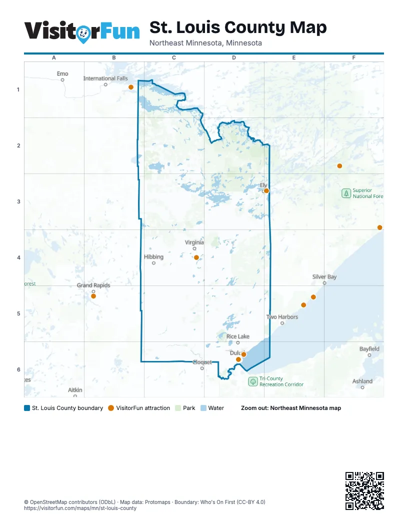
Maps inside St. Louis County
2 maps inside, from the street map of St. Louis County down.
City
Town
Street index of St. Louis County
Each street on the sheet and the grid squares it crosses.
- Garfield AvenueD6
- John A. Blatnik BridgeD6
- Bong Memorial BridgeD6
- South 1st Avenue WestD3, C4, D6
- I-35 SouthD6
- I-35 South Entrance Ramp From Superior StreetD6
- I-35 South Entrance Ramp From Mesaba AvenueD6
- Blue Star Memorial Highway/34th Infantry (Red Bull) Division HighwayD6
- Speaker Irvin N. Anderson Memorial HighwayB1, C1, C2, C3, C4
- State Highway 73C3, C4, C5, C6
- Vermilion TrailD4, D5
- United States Route 2B5, C5, C6
- Rice Lake RoadD5, D6
- State Highway 37C4
- State Highway 169D3, E3, C4, D4
- Maple Grove RoadC6, D6
- West Arrowhead RoadD6
- Highway 169 WestB4, C4
- Miller Trunk HighwayD6
- East Superior StreetD6
- State Highway 194D6
- Main StreetD3, E3, C4, D4, D6
- State Highway 1D3, E3
- Grand AvenueD4, D6
- Highway 169D3
- Haines RoadD6
- Woodland AvenueD6
- Congdon BoulevardD6
- London RoadD6
- East BeltlineC4
- Vermilion Trail / Hwy4D4
- Piedmont AvenueD6
- West Michigan StreetD6
- West 3rd StreetD6
- West Superior StreetD6
- West 2nd StreetC4, D6
- Commonwealth AvenueD6
- Trinity RoadD6
- Mesaba AvenueD6
- Airport RoadC3, D6
- New Independence RoadC5
- Veterans' Evergreen Memorial DriveD6
- East Sheridan StreetD3, E3
- East Central EntranceD6
- West Central EntranceD6
- South Arlington AvenueD6
- East Calvary RoadD6
- North Arlington AvenueD6
- Elm StreetD3, C5
- North 3rd AvenueD6
- North Lake AvenueD6
- North 1st Avenue WestD3, C4, D6
- County Highway 103C4
- North 4th Avenue WestC4, D6
- Anchor Lake RoadC4
- North 21st Avenue EastE3, D6
- Representative Thomas Rukavina Memorial BridgeC4
- Carlton StreetD6
- South 21st Avenue EastD6
- Gray DriveC4
- West Sheridan StreetD3
- 2nd Avenue Exit RampD6
- Specialist Noah Pierce BridgeC4
- trunkC3
- Piedment AvenueD6
- Oldenberg ParkwayD6
- Highway 5B3, C3, C4, C5
- Town Line RoadC2, B4, C4, D4, E4, D5
- Highway 7C4, C5, C6
- Pequaywan Lake RoadD5, E5
- Highway 21D3, D4
- Highway 8C5, D5
- Swan Lake RoadC5, D6
- Comstock Lake RoadC5, D5
- Highway 110D4
- Lavaque RoadD5, D6
- Highway 135 NorthD3, D4
- Midway RoadD6
- Morris Thomas RoadC6, D6
- West Skyline ParkwayD6
- State Highway 135C4, D4
- Range Line RoadC2, C3
- Industrial RoadC6, D6
- County Highway 100D4
- Martin RoadD6
- Howard Gnesen RoadD5, D6
- Wilson RoadC4, D4, C6
- Jean Duluth RoadD5, D6
- Ugstad RoadD6
- Highway 44D4, E4, E5
- Anderson RoadC3, C4, D4, C6, D6
- County Highway 21 NorthD3
- Fox Farm RoadD5
- North Shore DriveD5, E5, C6, D6
- Normanna RoadD5
- Saint Louis River RoadD4, D6
- Stebner RoadD6
- Highway 21 NorthD3
- Taft RoadD5
- Miller Trunk RoadC4
- Getchell RoadD6
- 1st AvenueD3, C4, D5, C6
- County Highway 5C4, C6
- West 1st StreetC4, D6
- Mineral AvenueC4
- East Skyline ParkwayD6
- Becks RoadD6
- East 4th StreetD6
- Fish Lake RoadD5
- Stark RoadD6
- Dupont RoadC4
- Road 37D4
- East 3rd StreetC4, D6
- East 2nd StreetD6
- Glenwood StreetD6
- Mud Lake RoadC4, D6
- Rollins RoadE5
- East 40th StreetC4
- Beaver River RoadD5
- Kennedy Memorial DriveD4
- County Highway 60C4
- County Road 101C4
- County Highway 16B4, C4
- Mountain DriveD6
- South 1st AvenueC4, D6
- Mall DriveD6
- North 9th Avenue WestC4, D6
- 2nd StreetC3, C4, C6, D6
- West 25th StreetC4
- South BroadwayC4
- 9th Street NorthC4
- Kenwood AvenueD6
- Cody StreetD6
- Fairbanks RoadD4, E4, C6
- 8th Street SouthC4, D6
- Lavaque Bypass RoadD6
- 4th StreetC3, C4, D4, D6
- Fayal RoadC4
- County Highway 3D6
- East 25th StreetC4
- North Central AvenueD3, D6
- County Highway 63C4
- County Highway 70D3
- West College StreetD6
- North 6th Avenue EastD3, D6
- Dillon RoadC4
- North 2nd Avenue WestD3, C4, D6
- North 2nd AvenueD5, D6
- South Boundary AvenueD6
- Highway 101C4
- Raleigh StreetD6
- South 23rd Avenue WestC4, D6
- South 2nd Avenue WestD3, C4, D6
- North 12th Avenue EastE3, D6
- Snively RoadD6
- Highland StreetD6
- North 24th Avenue WestD6
- Nichols AvenueC4
- North 27th Avenue WestD6
- North 10th Avenue EastE3, D6
- French River RoadD5
- Loberg AvenueD6
- County Highway 110D4
- West 41st StreetC4
- East McCuen StreetD6
- Observation RoadD6
- North 14th Avenue EastE3, D6
- North 11th Avenue WestC4, D6
- North Ugstad RoadD6
- South Central AvenueD3, D6
- County Highway 7C4, C6
- West Lake StreetC4
- Waseca Industrial RoadD6
- 5th StreetC4, D6
- Wallace AvenueD6
- West 3rd Avenue NorthD4
- South 9th Avenue WestC4
- 3rd Avenue NorthwestC4
- Grinden DriveD6
- North 46th Avenue WestD6
- North 10th Avenue WestC4, D6
- Ely-Babbitt RoadD3
- County Highway 61C4
- East Lake StreetC4
- County Highway 60 NorthC4
- North Boundary AvenueD6
- North 40th Avenue WestD6
- East Buffalo StreetD6
- West Saint Marie StreetD6
- North BroadwayC4
- Lower Michigan StreetD6
- Mike Colalillo DriveD6
- 40th StreetC4
- Central Entrance DriveD6
- Bristol StreetD6
- North Hoover RoadC4
- West 42nd StreetC4
- Market StreetD6
- Main Street NorthD4
- County Highway 21D3
- North 21st Avenue WestD6
- Junction AvenueD6
- Morton RoadC4
- South Hoover RoadC4
- North 5th AvenueD6
- South 17th Avenue EastE3, D6
- South 2nd AvenueD6
- South 12th Avenue EastE3, D6
- North ShoreE3
- South 16th Avenue WestC4
- South 27th Avenue WestD6
- South 14th Avenue EastE3, D6
- East Arrowhead RoadD6
- East Saint Marie StreetD6
- State Highway 39D6
- Iron World RoadC4
- East 5th AvenueC5
- South 40th Avenue WestD6
- McInnes RoadC4
- County Highway 60 SouthC4
- County Highway 102C4
- County Highway 13D6
- Oliver BridgeD6
- South 21st Avenue WestD6
- Scenic DriveE5
- County Road 16B4
- Wales RoadE5
- Dillon Rd / State Highway 73C4
- Echo TrailC2, D2, D3, E3
- Crane Lake RoadC2, C3
- Munger Shaw RoadD5, D6
- Highway 22B3, C3
- Long Lake RoadC4, D4
- Arkola RoadC5
- Highway 25C3, C4
- Nett Lake RoadB2, C2, C3
- Three Lakes RoadC5, D5
- Osborn RoadC3, C4
- Brimson RoadD4, E4, D5
- Highway 29C5
- County Highway 133C5
- Willow River RoadB3, C3
- Zim RoadC4
- Highway 115C3, D3
- Highway 133B5, C5
- Old Highway 169D3, B4, C4
- Wahlsten RoadD3
- Salo RoadD3, C4, C5
- Ash River TrailC1, C2
- Seville RoadC6, D6
- Samuelson RoadC3, C6, D6
- Canosia RoadD5, D6
- Lindahl RoadD6
- Grant-McMahan BoulevardD3, E3
- County Highway 25C3, C4
- Vermilion DriveC3
- Highway 47C5
- Arnold RoadC5, D5, D6
- County Road 77D3
- Lismore RoadD5
- Pine DriveC2, C4, C6
- Orr-Buyck RoadC2
- Taylor RoadD3, D6
- County Road 444C4
- Rossini RoadD5, E5
- Bodas RoadC4, D4
- McQuade RoadD5, D6
- Highway 23C2
- SmithC4
- Giants Ridge RoadD3, D4
- Trigstad RoadD4
- Bear Head State Park RoadD3
- Lost Lake RoadD3, D4, D5
- Hermantown RoadD6
- McCamus RoadC6
- Ralph RoadC3
- Graff RoadC4, B6, C6
- Heritage TrailD4
- Spirit Lake RoadC4
- Lakewood RoadD5, D6
- West Tischer RoadD6
- Gamma RoadB1
- Iron Junction RoadC4
- Lester River RoadD5, D6
- West Pioneer RoadD5
- Kensington DriveD4
- County Highway 29C5
- Brandon RoadD4, C6
- County Highway 99D4
- Stepetz Road 53D4
- Twin Lakes DriveC6
- Schultz RoadD5
- Caribou Lake RoadD6
- Homestead RoadE5
- Olson Road EastC3
- Clyde RoadC4, D4
- East Bodas RoadD4
- Evergreen RoadD4, C6, D6
- Solway RoadD6
- Emerson RoadD5
Things to do on the St. Louis County map
- Adventure Zone Duluth
- Aerial Lift Bridge
- Bear Head Lake State Park
- Canal Park
- Duluth Entertainment Convention Center (DECC)
- Glensheen Mansion
- Great Lakes Aquarium
- International Wolf Center
- Iron Range
- Lake Vermilion-Soudan Underground Mine State Park
- Minnesota Discovery Center
- North Shore Scenic Railroad
- Tweed Museum of Art
Places on the map
- Aerie Lake
- Agassa Lake
- Agawato Lake
- Alango Township
- Alborn Township
- Alden Lake
- Alden Township
- Amundsen Lake
- Anchor Lake
- Anchor Lake Rest Area
- Angleworm Lake
- Angora Township
- Argo Lake
- Armstrong Lake
- Arnold
- Arrowhead Lake
- Arrowhead Township
- Arthur Lake
- Artichoke Lake
- Ash Lake
- Bear Head Lake State Park
- Big Aspen Trail System
- Burntside State Forest
- Canthook Lake Primitive Management Area
- Cloquet Valley State Forest
- Gichigami Ziibi WMA
- Kabetogama State Forest
- Lake Jeanette State Forest
- McCarthy Beach State Park
- Sturgeon River State Forest
- Sundial Lake Primitive Management Area
- The Ledgend
- Voyageurs National Park
- Weeny Lake Primitive Management Area
- Whiteface River State Forest
Next to St. Louis County
- Aitkin
- Ashland
- Bayfield
- Cloquet
- Emo
- Grand Rapids
- International Falls
- Silver Bay
- Two Harbors
© OpenStreetMap contributors, Open Database License, openstreetmap.org/copyright · Map data: Protomaps · Boundary: Who's On First (CC-BY 4.0); Quattroshapes (CC BY 2.0)