

Minnesota map
Hopkins map
About 19,462 people live here (Census Bureau, 2024 estimate). The sheet's index lists 178 streets; Excelsior Boulevard, Minnesota State Highway 7 and 2nd Street Northeast cross the most grid squares. Also on it: Oak Ridge Country Club, Blake School and Valley Park.
Open the map (PDF, US Letter)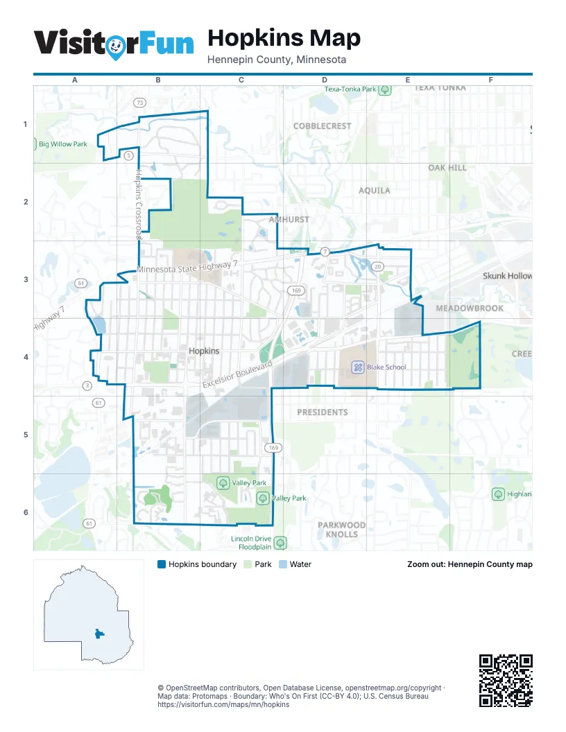
Street index of Hopkins
Each street on the sheet and the grid squares it crosses.
- Honeywood LaneA1
- Minnetonka BoulevardA1, B1, C1
- Hopkins CrossroadB1, B3
- Loring RoadB1, B2
- Manitoba RoadB1
- Mill RoadB1, C1, B2
- Saint Albans Road EastB1, C1
- Saint Albans Road WestB1
- Atwater StreetC1, C2
- Fletcher PlaceB2
- Webster PlaceB2
- Bridal LaneC2, C3
- Cottage DownsC2
- Drillane CircleC2
- Drillane RoadC2
- Edgemoor DriveC2, C3
- North Drillane RoadC2
- Oakridge RoadC2, C3
- Park TerraceC2
- South Drillane RoadC2
- Valley WayC2, C3
- 20th Avenue NorthA3, A4
- 21st Avenue NorthA3, A4
- 2nd Street NorthA3, B3
- Lake Street ExtensionA3
- North 4th StreetA3, B3, C3
- Shady Oak RoadA3, A4
- West Park RoadA3
- Wyndham Hill DriveA3
- 10th Avenue NorthB3, B4
- 11th Avenue NorthB3, B4
- 12th Avenue NorthB3, B4
- 13th Avenue NorthB3, B4
- 14th Avenue NorthB3, B4
- 15th Avenue NorthB3, B4
- 16th Avenue NorthB3, B4
- 17th Avenue NorthB3, B4
- 18th Avenue NorthB3, B4
- 19th Avenue NorthB3, B4
- 2nd Street NorthwestB3, C3, C4
- 3rd Street NorthB3, C3
- 5th Street NorthB3
- 7th Street NorthB3
- Elmo RoadB3
- Minnesota State Highway 7B3, C3, D3, E3
- Minnetonka Mills RoadB3, C3
- Oakvale Road SouthB3
- Robinwood LaneB3
- State Highway 7 Service RoadB3, C3
- 2nd Street NortheastC3, D3, E3, D4
- 5th Avenue NorthC3, C4
- 6th Avenue NorthC3, C4
- 7th Avenue NorthC3, C4
- 8th Avenue NorthC3, C4
- 9th Avenue NorthC3, C4
- Althea LaneC3
- Burnes DriveC3
- Campbell DriveC3
- East Farmdale RoadC3, D3
- Gethsemane RoadC3
- Hazel LaneC3
- Herman TerraceC3, D3
- Oak Glen DriveC3, C4
- Oak Ridge PlaceC3
- Sweet Briar LaneC3
- Washington Avenue NorthC3, C4
- Wayside Road EastC3, D3
- Wayside Road WestC3
- West Farmdale RoadC3
- Wilshire WalkC3
- Abbie LaneD3
- Cambridge StreetD3, E3
- Cameron CourtD3
- Harrison AvenueD3, D4
- Herman CourtD3
- Hiawatha AvenueD3, E3
- Hollyhock LaneD3
- Jackson Avenue NorthD3, D4
- Kassie CourtD3
- Lake Street NortheastD3, E3
- Lindsey LaneD3
- Madison Avenue NorthD3
- Madison Circle NorthD3
- Madison Circle SouthD3
- Monroe Avenue NorthD3, D4
- Monroe PlaceD3
- North Van Buren PlaceD3
- North Van Buren TerraceD3
- North Van Buren TrailD3
- North Van Buren WayD3
- Oak Park LaneD3
- Parkside BoulevardD3
- Regency Lane EastD3
- Regency Lane WestD3
- Saint Louis StreetD3, D4
- Shady Side CircleD3
- Sunnyside LaneD3
- Tyler Avenue NorthD3, D4
- Van Buren Avenue NorthD3, D4
- Blake Road NorthE3, E4
- Division StreetE3
- Murphy AvenueE3
- Oxford StreetE3
- Powell RoadE3, E4
- Texas Avenue SouthE3
- 19th Avenue SouthA4, B4
- 1st Street NorthA4, B4, C4
- 1st Street SouthA4, B4, C4
- 20th Avenue SouthA4
- Bradford RoadA4
- Main StreetA4
- MainstreetA4, B4, C4
- 10th Avenue SouthB4, B5
- 11th Avenue SouthB4, B5, B6
- 12th Avenue SouthB4, B5
- 13th Avenue SouthB4, B5
- 15th Avenue SouthB4, B5
- 16th Avenue SouthB4, B5
- 17th Avenue SouthB4, B5
- 18th Avenue SouthB4
- Excelsior BoulevardB4, C4, D4, E4, F4
- Renaissance CourtB4
- 2nd Avenue SouthC4, C5, C6
- 3rd Street SouthC4
- 5th Avenue SouthC4, C5
- 6th Avenue SouthC4, C5, C6
- 7th Avenue SouthC4, C5, C6
- 8th Avenue SouthC4, C5
- 9th Avenue SouthC4, C5, C6
- Milwaukee StreetC4, D4
- Park LaneC4
- Ridgewood DriveC4
- Washington Avenue SouthC4
- 1st Street SoutheastD4
- Blake School LaneD4
- Harrison Avenue NorthD4
- Harrison Avenue SouthD4
- Jackson Avenue SouthD4
- Monroe Avenue SouthD4
- Pierce AvenueD4
- Polk AvenueD4
- Van Buren Avenue SouthD4
- Ashley RoadE4
- Blake Road SouthE4
- Boyce StreetE4
- Goodrich StreetE4
- Grove PlaceE4
- Hawthorne RoadE4
- Holly RoadE4
- Homedale RoadE4
- Interlachen RoadE4
- John StreetE4
- Maple Hill RoadE4
- Meadowbrook RoadE4
- Oakwood RoadE4
- Preston LaneE4
- Spruce RoadE4
- 14th Avenue SouthB5
- 5th Street SouthB5, C5
- 6th Street SouthB5, C5
- 7th Street SouthB5, C5
- Landmark Trail NorthB5, B6
- 8th Street SouthC5, C6
- Park Valley Drive EastC5
- Park Valley Drive WestC5
- Feltl CourtB6
- Landmark Trail SouthB6
- Smetana RoadB6, C6
- Trailwood NorthB6
- Trailwood SouthB6
- Wagon Wheel RoadB6
- Westbrooke WayB6, C6
- Woodhill CourtB6
- Nine Mile Cove EastC6
- Nine Mile Cove NorthC6
- Nine Mile Cove SouthC6
- Old Settlers TrailC6
- Smetana DriveC6
Places on the map
- Ace Spirits
- Barrett Lawn Care
- Blake School
- Buffer Park
- Burnes Park
- Central Park
- Cottageville Park
- Dollar Tree
- Driskill's Food
- Gethsemane Lutheran Church
- Harley Hopkins Park
- Holiday
- Holiday Gas Station
- Hopkins Center for the Arts
- Hopkins City Hall
- Hopkins Health & Wellness Center
- Hopkins Honda
- Hopkins Library
- Hopkins Post Office
- Hopkins Refuse Drop Off
- Interlachen Park
- Maetzold Field
- MGM Liquor Warehouse
- Municipal Ramp
- NAPA Auto Parts
- Oak Ridge Country Club
- Pizza Lucé
- Shady Oak Pond
- Smith Nielson Automotive Service
- The Artery
- The Depot Coffee House
- The Glenn Hopkins
- The Wild Boar
- U.S. Bank
- Valley Park
- Walgreens
- Walser Chrysler Jeep Dodge Ram
- Wendy's
- Zion Lutheran Church
Next to Hopkins
- Amhurst
- Aquila
- Cobblecrest
- Lenox
- Meadowbrook
- Minnehaha
- Oak Hill
- Parkwood Knolls
- Presidents
- Skunk Hollow
- South Oak Hill
- Texa Tonka
© OpenStreetMap contributors, Open Database License, openstreetmap.org/copyright · Map data: Protomaps · Boundary: Who's On First (CC-BY 4.0); U.S. Census Bureau















