

Minnesota map
Kanabec County map
About 16,608 people live here (Census Bureau, 2024 estimate). The sheet's index lists 300 streets; State Highway 47, Rainbow Street and Mahogany Street cross the most grid squares. Things to do inside the boundary: Minnesota Goose Garden.
Open the map (PDF, US Letter)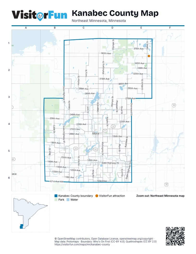
Street index of Kanabec County
Each street on the sheet and the grid squares it crosses.
- 120th AvenueB6, C6, D6, E6
- State Highway 70C5, D5, E5, E6
- State Highway 107E5, D6, E6
- Forest Avenue EastC4, D4
- State Highway 65D1
- Veterans' Evergreen Memorial DriveE4
- State Highway 47B1, B2, B3, B4, B5, B6, C6
- County Road 4B6, C6
- County Road 26B4
- Dahl RoadE3
- Main Avenue NorthD6
- Mahogany StreetD1, D2, D3, D4, D5, D6
- Olympic StreetD1, D2, D3, D4, D5, D6
- Rainbow StreetE2, D3, E3, D4, E4, D5, E5
- Harbor StreetC2, C3, C4, C5, C6
- Jade StreetC3, C4, C5, C6
- 300th AvenueD2, E2, C3, D3, E3
- 290th AvenueB3, C3, D3, E3
- 240th AvenueB4, C4, D4
- 210th AvenueB4, C4, D4
- Cable StreetB3, B4, B5, B6
- 220th AvenueB4, C4, D4
- 130th AvenueB6, C6, D6
- 180th AvenueD1, B5, C5, D5, E5
- Quail StreetD3, D4, D5, D6
- Ivory StreetC1, C2, C3, C4, C5, C6
- 110th AvenueE1, B6, C6, D6
- Garden StreetC4, C5, C6
- Naples StreetD2, D4, D5, D6
- 320th AvenueB2, C2, D2, E2
- 160th AvenueB5, C5, D5
- 230th AvenueB4, C4, D4
- 310th AvenueB2, C2, D2, E2
- Plum StreetD3, D4, D5, E5
- Legend StreetC3, D3, C4, C5, C6
- 200th AvenueB4, C4, D4
- 421st Avenue NorthwestB6, C6
- Pheasant StreetD3, D4, D5, D6
- 340th AvenueD2, E2
- 250th AvenueB3, C3, D3, E3
- 330th AvenueD2, E2
- 270th AvenueC3, D3, E3
- Velvet StreetE1, E2
- 370th AvenueD1, E1
- 170th AvenueB5, D5, E5
- Delta StreetB3, B5, B6
- Falcon StreetC1, B2, B3, B4, B5
- 280th AvenueC3, D3, E3
- Nightengale StreetD2, D4, D5, D6
- 260th AvenueC3, D3, E3
- 145th AvenueC5, D5
- Imperial StreetC3, C4, C5, C6
- 150th AvenueB5, C5, D5
- 155th AvenueB5, C5, D5, E5
- 140th AvenueB5, C5
- 190th AvenueB5, C5
- 195th AvenueD4, E4
- Bear StreetB5, B6
- Uniform StreetE1, E2, E3
- 125th AvenueB6, C6, D6
- Fish Lake DriveC5
- Eagle StreetB5, B6
- Keystone StreetC3, C4, C5, C6
- 315th AvenueC2, D2, E2
- King RoadC5, C6
- 153rd AvenueC5, D5
- Teal StreetE1, E2, E3
- 103rd AvenueC6, D6
- 113th AvenueC6, D6
- 205th AvenueB4, C4
- Quarter StreetD4, D6
- 175th AvenueB5, D5
- Regent StreetE5, E6
- 360th AvenueD1, E1
- 225th AvenueD4, E4
- Lumber StreetD3, D5, D6
- Liberty StreetD4, C5, D5, D6
- 380th AvenueB1, C1, D1, E1
- Joplin StreetC3, C4
- Queen StreetD5, D6
- 421st Avenue NortheastD6, E6
- 115th AvenueB6, C6, D6, E6
- 233rd AvenueC4, D4
- County Road 20E2, E3
- Flintstone StreetC2, C3, C5
- 133rd AvenueD6, E6
- 245th AvenueC4
- Grand StreetC3, C6
- East Maple AvenueC4, D4
- 185th AvenueD5, E5
- Union StreetC4, E5
- Jefferson StreetC3, C5, C6
- Pine StreetC4, E5
- Howe AvenueC4, D4
- 105th AvenueC6, D6
- Owl StreetD5
- 135th AvenueC6, D6
- South Walnut StreetC4, C5
- Poplar StreetD4
- Rice StreetE6
- Grove StreetC4
- 355th AvenueE1
- 183rd AvenueD5
- Hill AvenueB5
- North Grove StreetC4
- South Union StreetC4, C5
- Ann Lake RoadB4
- West Maple AvenueC4
- 336th AvenueC2
- East Rutherford StreetB5
- 126th AvenueC6
- 143rd AvenueD5, E5
- South Liberty StreetD5
- County Road 24D2
- Quamba StreetD4
- South Hill AvenueB5
- Wilkinson AvenueD4
- 360th StreetB2
- County Road 30E1
- West George StreetB5
- West Central AvenueC4
- Porter StreetD5
- 6th Street NorthwestD6
- North Hill AvenueB5
- Whited AvenueD4
- Flamingo Street NorthwestC6
- Roanoke Street NorthwestC6
- Hupp Street NortheastE6
- Cherry Avenue NorthD6
- North Walnut StreetC4
- 140th StreetB6
- County Road 131B1, E3
- North Union StreetC4
- County Highway 5E6
- 190th StreetB5
- County Road 5D4
- Friesland RoadE2
- Rice Lake Road NortheastD6
- Pokegama Lake RoadE5
- Groningen RoadE1
- Grindstone Lake RoadE1
- Sherwood StreetE3, E4, E5, E6
- Pilot StreetD1, D2, D3
- Well StreetE1, E2, E3
- Hickory StreetC4, C5, C6
- Quarry StreetD2, D3, D4
- Arctic TrailB4
- 350th AvenueD2, E2
- 50th AvenueB4, B5, B6
- Skyview StreetE2, E3
- 215th AvenueD4, E4
- Kite StreetC1, C2, C3
- Woods RoadC1, C2
- 297th AvenueC3
- Riverview DriveD3
- Orchard StreetD4, D5, D6
- Ironwood StreetC3
- Melody StreetD5, D6
- Holly TrailC5
- 375th AvenueE1
- Munkelwitz RoadC1
- White Tail DriveD3
- East Hardwood LaneD3
- North Lake DriveC3, D3
- Spruce StreetE1, C4, E5
- Island View DriveC5
- Apple StreetB4
- McGrew RoadC1
- North Pine View Beach RoadD3
- 163rd AvenueD5
- 348th AvenueC2
- South Pine View Beach RoadD3
- Oslin RoadD4, D5
- 117th AvenueC6
- West Hardwood LaneD3
- 343rd AvenueB2
- Grouse View DriveD3
- 235th AvenueD4, E4
- Woodmor RoadD4
- 187th AvenueD5, E5
- Old Hwy 23 WestC5
- West Wildlife DriveD3
- 265th AvenueB3
- Salmonson River RoadC3
- Aleta TrailE1
- West River DriveD3
- Old Hwy 23 NorthC5
- 10th AvenueB1
- Sundet RoadC5
- 165th AvenueE5
- Nelson's RoadC3
- Forest Shores RoadB4
- Pine Ridge Road SouthC4
- 127th AvenueC6
- Archer StreetB6
- Roeschlein RoadC1
- Lakeview DriveD4
- Lake Eleven DriveE1
- Glacier RoadE1
- Indigo StreetC5
- 107th AvenueB6, C6
- 390th AvenueD1
- 263rd AvenueD3
- 253rd AvenueC3, D3
- Riverside StreetC4
- 247th AvenueD3, D4
- Ann River DriveC5
- 255th AvenueC3
- 257th AvenueC3
- East Wildlife DriveD3
- 305th AvenueD2
- Usher StreetE2
- Lindew Wood TrailC5
- Wood StreetC4
- 226th AvenueC4
- 273rd AvenueD3
- Collin StreetC4
- Hornet StreetC3
- 382nd AvenueE1
- South Brook View DriveC5, D5
- Dove StreetB5
- 130th StreetB6
- Blossom StreetB6
- 221th AvenueC4
- Lake DriveC6
- Frankie LaneC4, C5
- 303rd AvenueC2
- Cotton Tail CircleD3
- County Road 100E1
- Frontage RoadC5
- Dala LaneC5
- 172nd AvenueB5
- Burnett DriveC4
- Forest Avenue WestC4
- 245th LaneC4
- Atwater StreetB5
- 390th Avenue / 100th StreetE1
- Bean AvenueC4
- Riverdale RoadD5
- North Industrial RoadC4, D4
- Edwards AvenueC4, D4
- Dill StreetB5
- Shore DriveC5
- Sunrise CircleD3
- Hollow DriveB4, C4
- Rolling Oaks DriveD5
- Duck View CircleD3
- Fair Avenue WestC4
- North 9th StreetC4
- Peterson RoadC1, C2
- McLean StreetC4
- Gilbertsons HillC3
- Debra LaneC6
- Sunset StreetE2
- Carlson Game FarmC4
- Sorensons RoadC3
- Chris HavenC3
- Portage AvenueC4, D4
- Pine Knoll RoadC3
- 2nd StreetC4
- South Park StreetC4
- South Wood StreetC4
- South Grove StreetC4
- Carda CourtB4
- Svendson RoadD3
- Access RoadD3
- Haggberg RoadB1
- North Brook View DriveC5, D5
- Morrison StreetC4
- Little Tealander DriveD3
- Hillside CircleD3
- Oak StreetC4, E5
- Watkins StreetC4
- Meadowlark LaneC5
- Juniper StreetC4
- Jewell StreetD4
- 375th LaneD1
- Elmers LaneC5
- East Anderson StreetB5
- Echo DriveC5
- Vern DriveC5
- 112th AvenueE6
- River Oaks CircleD5
- Pomroy Beach DriveD3
- Rockwood ElbowC3
- County Road 68D4
- Raven StreetE5
- Pine Ridge Road NorthC4
- Industrial Park RoadD4
- Clark StreetC4
- Evergreen StreetC4, B5
- 365th AvenueE1
- Larson DriveC5
- Northland RoadC3
- Stegeman TrailC5
- Wilkins RoadD5
- Lyndale StreetD3
- Pine Woods TrailC5
- Vista StreetE1
- Nelson AvenueD4
Things to do on the Kanabec County map
Places on the map
- Ann Lake
- Ann Lake Township
- Ann Lake Wildlife Management Area
- Arthur Township
- Bean Dam Wildlife Management Area
- Beauty Lake
- Brunswick Township
- Comfort Township
- Devils Lake
- Eagles Cove Resort
- Featherbed Lake
- Fish Lake
- Ford Township
- Grass Lake Township
- Grasston
- Hay Brook Township
- Hillman Township
- Kanabec Township
- Knife Lake
- Knife Lake Township
- Kroschel Township
- Lake Eleven
- Lake Five
- Lake Full of Fish
- Lewis Lake
- Long Lake
- Mora
- Mora Lake
- Mud Lake
- Ogilvie
- Peace Township
- Pennington Lake
- Pomroy Lake
- Pomroy Township
- Quamba
- Rice Lake
- Snake River State Forest
- South Fork Township
- Thirteen Lake
- Whited Township
Next to Kanabec County
- Milaca
© OpenStreetMap contributors, Open Database License, openstreetmap.org/copyright · Map data: Protomaps · Boundary: Who's On First (CC-BY 4.0); Quattroshapes (CC BY 2.0)















