

Minnesota map
Prior Lake map
About 28,018 people live here (Census Bureau, 2024 estimate). The sheet's index lists 300 streets; Highway 13 South, Wilds Parkway Northwest and Marschall Road cross the most grid squares. Things to do inside the boundary: Mystic Lake Casino Hotel.
Open the map (PDF, US Letter)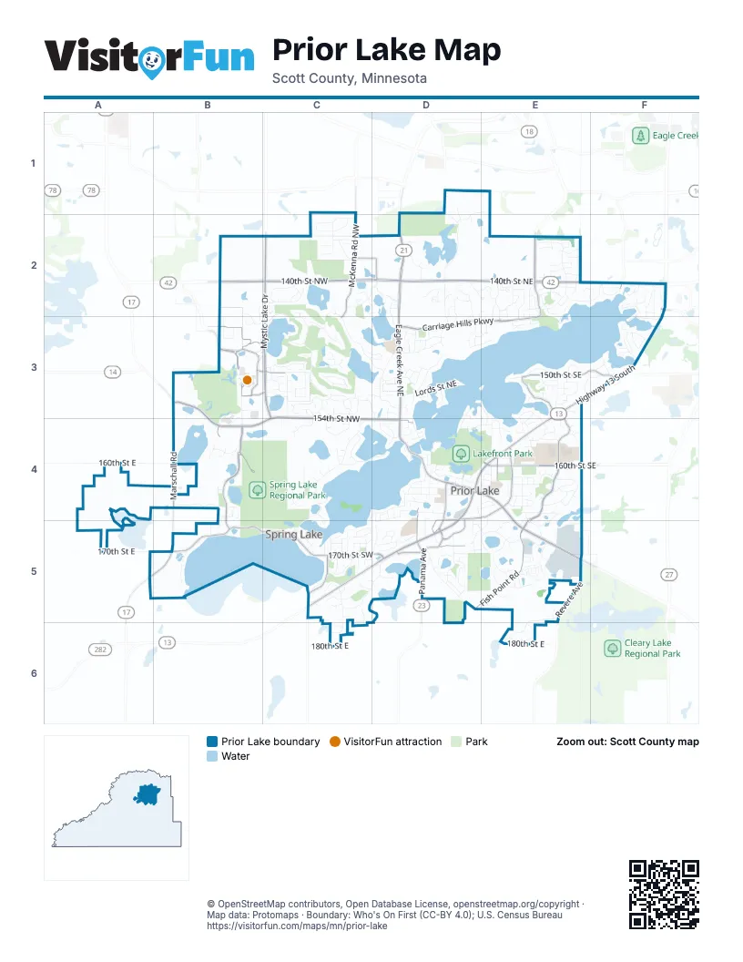
Street index of Prior Lake
Each street on the sheet and the grid squares it crosses.
- 140th Street NortheastD2, E2, F2
- 140th Street NorthwestB2, C2, D2
- Eagle Creek Avenue NortheastD2, D3, D4
- Highway 13 SouthF2, E3, F3, D4, E4
- Langford Boulevard /Richard J. Ames Memorial HighwayC5, D5
- Richard J. Ames Memorial HighwayD4, D5
- Eagle Creek AvenueD1, D2
- Langford Boulevard/Richard J. Ames Memorial HighwayD5
- Jordan Avenue SoutheastE4
- Egan DriveE2
- Herrgott Memorial DriveD1
- Eagle Creek Avenue /Richard J. Ames Memorial HighwayD4, E4, E5
- Marschall RoadB3, B4, A5, B5
- Eagle Creek Avenue SoutheastD4
- County Road 18E2
- Panama AvenueD5
- Five Hawks AvenueD4, D5
- Mystic Lake DriveC2, C3, C4
- 154th Street NorthwestC3, B4, C4, D4
- Fish Point RoadE4, D5, E5
- Carriage Hills ParkwayD3, E3
- 160th Street SoutheastE4
- Howard Lake RoadB3, B4
- Stemmer Ridge Road NorthwestB4, B5
- Dakota ParkwayB3
- Fish Point Road SoutheastE3, E4
- Shoreline BoulevardB5, C5
- Duluth Avenue SoutheastD4, D5
- McKenna Road NorthwestC1, C2, C3
- Franklin Trail SoutheastD4, E4
- 150th Street SoutheastE3, F3
- 170th Street SouthwestC5, D5
- Sioux Trail NorthwestB3
- Carriage Hill Road NortheastE2, E3
- Revere AvenueE5, E6
- Mystic Lake BoulevardB3, C3
- Sunset Trail SouthwestC5
- Tower Street SoutheastD5
- Spring Lake Road SouthwestC5
- Anna Trail SoutheastD4, D5
- Crest Avenue NortheastE2
- Stemmer Ridge Road orthwestB4
- Oakes Lane NorthwestB3, C3
- Shepherd's PathD2
- North Berens Road NWC2, D2
- Village Lake DriveD5
- South Park DriveF2
- Greenway Avenue NortheastF2
- Mystic Lake Drive NorthwestC3
- Wilds Parkway NorthwestB2, C2, B3, C3, C4
- Credit River Road SoutheastD4, E4, E5
- Wilds Ridge NorthwestC2, C3, D3
- Northwood Road NorthwestC4, C5
- Pike Lake Trail NortheastD2, D3
- Crossandra Street SoutheastE4
- Turner Drive SouthwestC5, D5
- Shady Beach Trail NortheastE2, F2, E3
- Wilderness Trail SoutheastE5
- Candy Cove Trail SoutheastE3, E4
- Mushtown RoadD5
- Jeffers Path NorthwestD3
- Bobcat Northwest TrailC3, C4
- Bluebird Trail NortheastD2, D3
- Fairlawn Shores Trail SoutheastE3
- Pleasant Street SoutheastD4
- Deerfield DriveE5
- Fountain Hills Drive NorthwestD2
- Belmont Avenue NorthwestB4
- Trailhead Lane SoutheastE5, E6
- Crownline Drive NortheastE2
- Fox Tail TrailC3, D3, D4
- Blind Lake Trail SoutheastE5
- Lords Street NortheastD3
- Sunray Boulevard SouthwestC5, C6
- 170th Street EastA5, B5, E5
- Coachman Lane NortheastD3
- 180th Street EastC6, E6
- Dakota Street SoutheastD4, E4
- West Avenue SoutheastD4
- Adelmann Street SoutheastE5
- Colorado Street SoutheastD4
- Fremont Avenue NorthwestC4
- Hampton Street NortheastE2
- Wood Duck Trail NorthwestC3
- Toronto Avenue SoutheastD5
- Aspen Avenue NortheastE2
- Meadowlawn TrailE2, E3
- Orion Road NorthwestC3
- Kop ParkwayD4
- Cougar Path NorthwestC2
- Manitou Road NortheastD3
- Brooks Circle SoutheastE4
- Main Avenue SoutheastD4, E4
- Oak Ridge Circle SoutheastE3
- Cedarwood Street NortheastE2
- West Woodland Trail NorthwestC2
- Hummingbird Trail NortheastD2, D3
- Glynwater Trail NorthwestC4
- Rutgers Street NortheastF2
- Wildwood Trail NorthwestC3
- Wood Duck Drive NorthwestC3
- Pike Lake RoadD1, D2
- Ferndale Avenue NortheastE2, E3
- Hawk Ridge Court NorthwestC4
- Wilds Path NorthwestC2
- Lyons Avenue SoutheastE4, D5, E5
- Wilds Lane NorthwestC3
- Jeffers Parkway NorthWestC2, D2
- Willow Beach Trail SouthwestC5
- Shore Lane NortheastE2, E3
- Sunray Circle SouthwestC5
- 160th Street EastA4, B4
- Kensington Avenue NortheastE2
- Cleary Trail SoutheastE6
- Industrial Circle SouthE5
- Little Crow DriveC2
- Pointe Pass NorthwestC3, D3
- Bluff Heights Trail SoutheastD4, E4
- Spruce TrailC5
- Fountain Hills Court NortheastD2
- Mystic Lake Boulevard NorthwestB3, C3, B4
- Island View Road NorthwestC4
- Ridgemont Avenue SoutheastE4
- Dakota Trail NorthwestC3
- Martindale Street NortheastD1, E1, D2
- Watersedge Trail NortheastF2, F3
- Sunset AvenueB5
- Sycamore Trail SouthwestC5
- Glendale Avenue SoutheastF3
- Wild Horse CircleC3
- Boudin Street NortheastF2, F3
- Green Oaks Trail SoutheastE3, F3
- Willow Lane SouthwestD5
- Basswood Circle SouthwestC5
- Island View Circle NorthwestC4, D4
- Lakeside Avenue SoutheastD4
- Commerce Avenue NortheastF2
- Raspberry Ridge Road NorthwestD3
- Fisher Avenue NortheastE2, E3
- Stonebriar Circle SouthWestC5, D5
- Victoria Curve SoutheastE4
- Oakland Beach Avenue SoutheastF3
- Prairiegrass Drive NorthwestB3
- Pershing Street SouthwestD4, C5, D5
- Rutledge Street SoutheastD4, E4
- Mniowe TrailC4
- Chestnut Lane NortheastD3
- Trillium Cove NortheastD2, E2
- Timothy Avenue NortheastF2, F3
- Westwood Drive SoutheastE4
- Amblewood Drive NortheastE2, E3
- Maple TrailF3
- Priorwood Street SoutheastD4
- Dove Court NortheastD2, E2, D3, E3
- Pondview Trail SoutheastD5
- Itasca Avenue SoutheastE4
- Markley Lake Drive SoutheastE4, E5
- Cardinal Ridge Trail SoutheastE4
- Grainwood Circle NortheastD4
- Conroy Street NortheastF2
- Highland Avenue NorthwestD4
- Rolling Oaks Circle NortheastD2, E2
- Bounty Street SoutheastE4
- Woodside Road SoutheastE4
- Breezy Point Road SoutheastD3, E3, E4
- Marsh Drive NortheastD2
- Shore Trail NortheastE3
- Knoll Ridge DriveC4
- Pixie Point Circle SoutheastE3
- Balsam Street SouthwestC5
- Horizon Trail SoutheastD5
- Enclave Court NorthwestD2, D3
- Cedarwood Trail NortheastE2
- Cottonwood Lane SoutheastE5
- Summer Street SoutheastE4
- Walter StreetC2
- Appaloosa Trail NortheastD3
- Skyline Avenue NorthwestD4
- Wilds View NorthwestC3
- Green Heights Trail SouthwestD4
- Griggs Street SouthwestC5
- Tahinka Place NorthwestC4
- Wacipi DriveB3
- Red Oaks Road SoutheastD3, D4
- Fountain Hills Drive NortheastD2
- Rustic Road SoutheastF3
- Dakota Trail EastC3
- Carriage Lane NortheastD3
- Overlook Drive SoutheastD5
- Center Road SouthwestC5
- Maves TrailE3
- Ponds Edge LaneE5
- Birchwood Avenue NortheastE2, E3
- Eau Claire Trail NortheastD4
- Glascow Southeast TrailF3
- Rosewood Road NortheastD3
- Inguadona Beach Circle SouthwestC4, D4, C5, D5
- Skuya DriveB4
- Brewer Drive NorthwestC2
- Pinnacle Circle NortheastE2
- Bridle Ridge Trail NortheastD3
- Willowwood Street SoutheastD5
- Creekside Circle SoutheastD4, D5
- Lost Horizon Circle SoutheastE3
- Saint Paul AvenueE4
- Willowwood Street SouthwestD5
- Cates Street SoutheastD4
- 138th Street WestE2
- Parkview Drive SoutheastE4
- Wilderness Ridge Road NorthwestC3
- Beach Street NortheastD3, E3
- Goldenview Lane SouthwestC5, C6
- Snell Court SoutheastE4
- Hidden Pond Trail NortheastD3
- Shady Beach Drive NortheastE2
- Shore Crest Drive NorthwestC2, D2
- Natalie Road NortheastF2
- Park Avenue SoutheastD4
- Woodview Court SoutheastD5
- Hope Street SoutheastE4
- Calmut Avenue NortheastD4
- 165th Street NorthwestB4
- Dewitte Avenue SouthwestC5
- Thunderbird CircleC2
- Elm Avenue SouthwestC5
- Willow Beach Street SouthwestC5
- Harbor Place NortheastF2
- Candlewood Lane NortheastE2
- East Oak Point Drive SoutheastE5
- Evanston Avenue SoutheastD4, E4
- Parkwood Drive SoutheastD5
- Epperson CircleE2
- Huron Street SoutheastE4
- Lilac Lane SoutheastE5
- Fawn Meadow Curve SoutheastE5
- Brunswick Avenue SoutheastD4, D5
- Mitchell Circle SoutheastE4
- Timber Trail SoutheastE3
- River Birch Place SoutheastE5
- Sheffield Terrace NEE2
- Ceyaka TrailB4
- Ridgewood Court SoutheastD5
- Fairway Heights Road NorthwestC3, D3
- Windsor LaneE5
- Mount Curve Boulevard SoutheastE4
- Shannon Trail SoutheastE3
- Raspberry Ridge Road NortheastD3
- Robin Road NortheastD2, D3
- Eagle Creek Circle NorthwestD3
- Parkview Lane NorthwestC2
- River Birch Lane SoutheastE5
- Timber Crest DriveD4, E4
- Trail of Dreams NorthwestB3, B4
- Lois LaneC2
- Brookmere Boulevard NorthwestB2, B3
- Horizon DriveE1
- Kent Street SouthwestC5
- Marlen Circle SoutheastE3, F3
- Vale Circle SouthwestC5
- Butternut Circle NorthwestC4, C5
- Estate Avenue SoutheastF3
- Skinner Street SouthwestC5
- Waterfall WayC2
- Ash Circle NortheastE2
- Edgewater Circle NortheastD3
- Cattail Court NortheastE2
- Raven Court NortheastE2, E3
- Station Place NorthwestD2
- Wildflower WayE2
- Hidden View Road NortheastE2, F2
- Dublin Road SoutheastD5, E5
- Timberwolf Trail NorthwestC3
- Kyla Way SoutheastE5
- Luther Road SoutheastE4
- Cove Point Circle NorthwestC2
- Wilderness Circle SoutheastE5
- Artic Circle NorthwestC4
- O Brien Court SouthwestD5
- 170th Street SoutheastD5
- Pheasant Meadow Lane SouthwestC5
- Hickory Circle SouthwestC5
- Wilds Ridge CourtC3
- Franklin Circle SoutheastE4
- Wilds DriveC2
- Simpkins Drive SouthwestD5
- Manor Road SoutheastE3, E4
- Hillcrest Street SoutheastD5, E5
- Sunrise Avenue SouthwestC5
- Marsh Street NorthwestD4
- Ida CircleD5
- Edinborough Avenue NortheastD3
- Westbury Avenue SouthwestD5
- Majestic Lane NorthwestD3, D4
- Sweetgrass Circle NorthwestC2
- Hemlock CircleD3, E3
- Minnesota Street SoutheastE4
- Wilds RidgeC3
- Apex Way NortheastE2
- Wildwood Circle SoutheastE4
- Memorial Trail SoutheastE4
Things to do on the Prior Lake map
Places on the map
- Al Mahmoud Foundation
- Arctic Lake
- Big Eagle's
- Blind Lake
- Boathouse Brothers Brewing Co
- Brewer
- Brooksville Hills Park
- Cardial Ridge Lake
- Cardinal Ridge Lake
- Cardinal Ridge Park
- Carlson Hardware Co
- Crystal Lake
- Eagle Creek
- Fish Point Park
- Hass Lake
- Hidden Oaks Middle School
- Howard Lake
- Jeffer's Park
- Jeffers Pond
- Jeffers Wildlife Pond
- Lakefront Lake
- Lakefront Park
- Lower Prior Lake
- Markley Lake
- Memorial Park
- Mystic Lake
- Mystic Lake Casino & Hotel
- North Reservation
- Pike Lake
- Rice Lake Park
- Shakopee Mdewakanton Sioux Community / Bdemayaṭo Oyate
- Skape
- Spring Lake Regional Park
- St Paul's Lutheran Cemetary
- The Wilds
- Twin Oaks Middle School
- Upper Prior Lake
- Valines Landing Seaplane Base
- Wilds Park
- Woodview Nature Area
© OpenStreetMap contributors, Open Database License, openstreetmap.org/copyright · Map data: Protomaps · Boundary: Who's On First (CC-BY 4.0); U.S. Census Bureau















