

Minnesota map
Scott County map
About 157,206 people live here (Census Bureau, 2024 estimate). The sheet's index lists 300 streets; Dakota Avenue, Natchez Avenue and 250th Street West cross the most grid squares. Things to do inside the boundary: Minnesota Renaissance Festival, Mystic Lake Casino Hotel and Valleyfair.
Open the map (PDF, US Letter)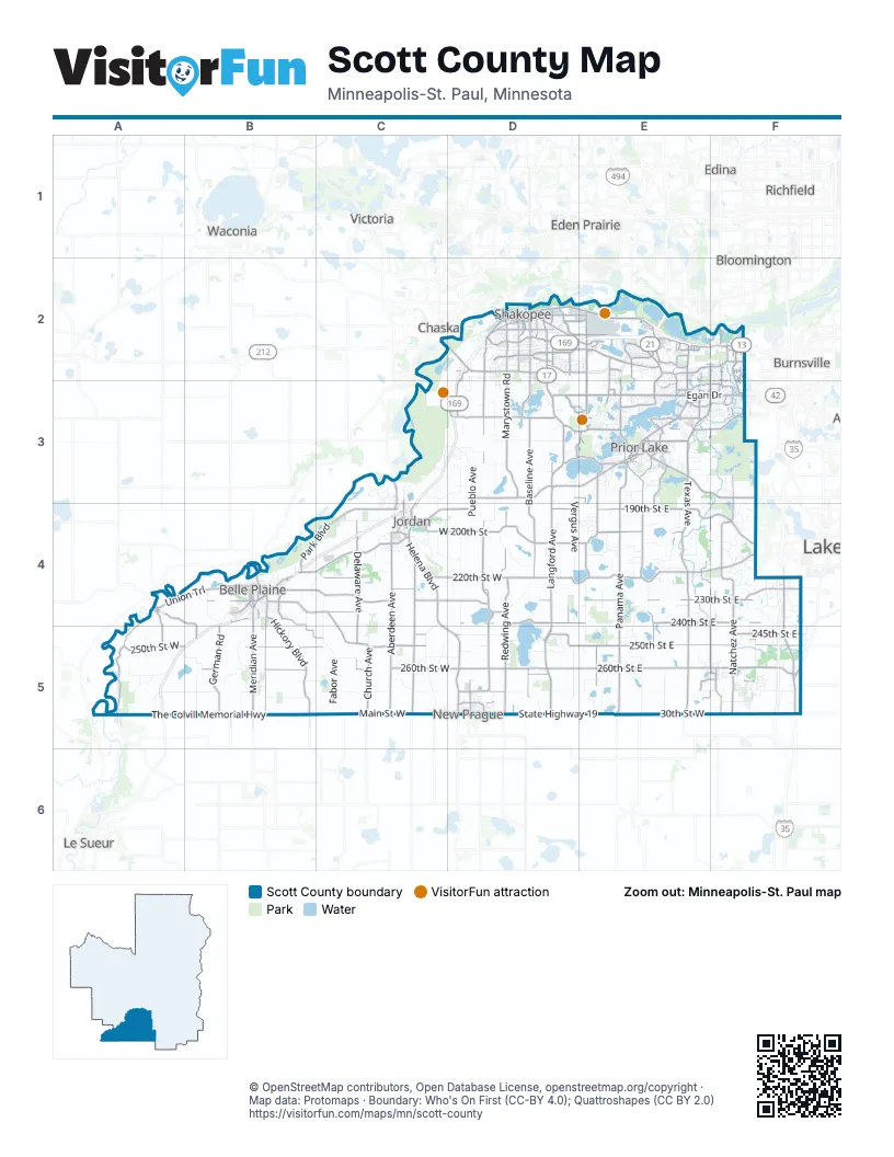
Maps inside Scott County
3 maps inside, from the street map of Scott County down.
Street index of Scott County
Each street on the sheet and the grid squares it crosses.
- Herrgott Memorial DriveE2
- Hansen AvenueE2
- Marschall RoadD2, D3
- Highway 13 SouthE2, E3
- Helena BoulevardC4, C5, D5
- 140th Street NorthwestD3, E3
- Egan DriveE3, F3
- 140th Street NortheastE3
- Country Trail West /Richard J. Ames Memorial HighwayD3, C4, D4
- County Road 101D2, E2
- County Highway 101D2, E2
- 1st Avenue WestD2
- Old Brick Yard RoadD2, D3
- Eagle Creek Avenue NortheastE3
- Langford Boulevard /Richard J. Ames Memorial HighwayD3, E3
- Main Street EastB4, D5
- Chestnut BoulevardC2, D2
- 1st Avenue EastD2
- Richard J. Ames Memorial HighwayE3
- Eagle Creek AvenueE2, E3
- Country Trail East /Richard J. Ames Memorial HighwayD3
- 4th Avenue NorthwestD5
- South Meridian StreetB4
- Broadway Street NorthC4
- Belle Plaine TrailB4
- North Walnut StreetB4
- Holmes Street SouthD2
- Broadway Street SouthC4
- Langford Boulevard/Richard J. Ames Memorial HighwayE3
- East 2nd Street /Richard J. Ames Memorial HighwayC4
- 2nd Street WestC4
- 2nd Street EastC4
- Jordan Avenue SoutheastE3
- East Main StreetB4
- Langford BoulevardD3
- County Road 42 WestF3
- State Highway 25B4
- John A. Johnson Memorial Highway/Sioux TrailB4
- 4th Avenue SouthwestD5
- Texas AvenueE3, E4, E5
- Langford AvenueD3, D4, D5
- 260th Street EastD5, E5, F5
- Panama AvenueE3, E4, E5
- The Colvill Memorial HighwayA5, B5
- Main Street WestB5, C5, D5
- Dakota AvenueF2, E3, F3, E4, F4, E5, F5
- Marystown RoadD2, D3
- Pillsbury AvenueF4, F5
- 220th Street WestC4, D4
- Dakota Street SouthD2, E3, F3
- 30th Street WestE5, F5
- State Highway 19D5, E5
- Cleary Lake Avenue /Richard J. Ames Memorial HighwayE3, F3
- Eagle Creek Avenue /Richard J. Ames Memorial HighwayE3
- County Road 18E2, E3
- West 150th StreetD3
- Mc Coll DriveE2, F2
- East 220th StreetD4, E4
- 130th Street WestD2, E2, F2
- Lucerne BoulevardE4, F4
- 220th Street EastE4
- Dakota Avenue SouthF2, F3
- Main StreetD2, F5
- West 137th StreetF2, E3, F3
- 217th Street EastE4
- County Road 78D2
- 185th Street EastD3, E3, F3
- Lynn AvenueF2, F3
- Glendale RoadF2, F3
- McColl DriveE2
- 10th Avenue WestD2
- 10th Avenue EastD2
- 263rd Street EastD5, F5
- Eagle Creek Avenue SoutheastE3
- McMahon LaneE4
- 185th Street East /Richard J. Ames Memorial HighwayF3
- Deuce RoadF5
- Dodd BoulevardF5
- East County Road 78D2
- Five Hawks AvenueE3
- 280th Street WestD5
- State Highway 300D2
- 185th Street West /Richard J. Ames Memorial HighwayF3
- Natchez AvenueF2, F3, F4, F5
- 250th Street EastD5, E5, F5
- 250th Street WestA5, B5, C5, F5
- 17th Avenue EastD2, E2
- Mystic Lake DriveE2, E3
- Aberdeen AvenueC4, C5
- Eagle Creek BoulevardD2, E2
- Redwing AvenueD4, D5
- 260th Street WestB5, C5, D5
- Delmar AvenueC4, C5
- 240th Street EastD4, E4, F4
- Old Highway 169 BoulevardB4, C4
- 230th Street WestB4, C4, D4
- Delaware AvenueC4, C5
- 230th Street EastD4, E4, F4
- 190th Street EastD4, E4
- Mushtown RoadE3, E4
- Hickory BoulevardB4, B5
- Drexel AvenueD4, D5
- Fairlawn AvenueE3, E4, E5
- Union TrailA4, B4, A5
- Laredo AvenueB4, B5
- Vernon AvenueF2, F4, F5
- Chatfield DriveA4, A5
- Baseline AvenueD3, D4, D5
- Meridian AvenueB4, B5
- 154th Street NorthwestD3, E3
- German RoadB5
- Union Hill BoulevardB4, C4, C5
- Kittson BoulevardB4, B5, C5
- Townline AvenueD2, D3
- Park BoulevardB4, C4
- 245th Street EastD5, F5
- Revere AvenueE3, E4, E5
- Credit River BoulevardE4, F4
- 160th Street SoutheastE3
- Southbridge ParkwayE2
- 225th Street WestB4, C4, D4
- Dakota ParkwayD3, E3
- West 200th StreetC4, D4
- Harlow AvenueD3, D4
- Vierling Drive EastD2
- Xeon AvenueD4
- Church AvenueC5
- Stagecoach RoadE2
- Fish Point RoadE3
- 4th Avenue EastD2, E2
- Valley View RoadD2, E2
- Canterbury RoadE2
- South Park DriveE3, F3
- Louisville RoadD2, D3
- Blakeley TrailA4, B4, B5
- Vierling Drive WestD2
- Carriage Hills ParkwayE3
- East 205th StreetD4, E4
- McKenna Road NorthwestE2, E3
- Shenandoah DriveD2
- Crossings BoulevardE2
- Judicial RoadF3, F4
- West 260th StreetD5
- 12th Avenue EastD2, E2
- Frontage RoadE2, F2, E3, C4
- Unbridled AvenueD2, E2
- Connelly ParkwayE3, F3
- North Sutton Lake BoulevardD4
- 126th Street WestD2, E2, F2
- Spencer StreetD2
- 154th Street WestE3, F3
- 200th Street EastE4
- 235th Street WestC4, D4
- Vernon Avenue SouthF2, F3
- Boone AvenueE2, E3, E4
- Quentin AvenueF2, F3
- East Enterprise DriveB4
- 150th Street WestE3, F3
- Howard Lake RoadD3, E3
- Columbus Avenue NorthD5
- Sarazin StreetD2
- Stemmer Ridge Road NorthwestD3, E3
- Louisiana AvenueE2, E3
- West Commerce DriveB4
- 225th Street EastF4
- West 240th StreetD4
- Malibu AvenueE4
- 228th Street WestC4
- West Highway 101 Frontage RoadE2
- Fish Point Road SoutheastE3
- Shoreline BoulevardD3, E3
- Hanrehan Lake BoulevardF3
- Quaker AvenueC3, C4
- 190th Street WestC4
- Zinn AvenueD4, D5
- Zane AvenueF4, F5
- Duluth Avenue SoutheastE3
- 6th Avenue WestD2
- 3rd Avenue WestD2
- Franklin Trail SoutheastE3
- Sunset DriveC4
- 7th Street NortheastD5
- 245th Street WestB5, C5, D5, F5
- 150th Street SoutheastE3
- 138th Street WestE3, F3
- Woodhill BoulevardF4
- Pike Lake RoadE2
- West State StreetB4
- Fuller Street SouthD2
- Harvest DriveE5, F5
- Hickory Boulevard SouthB4
- TintaocankuE2
- Inglewood AvenueF2, F3
- Dean Lakes BoulevardE2
- Quebec AvenueE2, E3
- Old Carriage Court NorthE2
- Independence DriveD2
- 123rd Street WestE2, F2
- Adams Street SouthD2
- Fuller StreetD2
- Sioux Trail NorthwestD3, E3
- 170th Street SouthwestE3
- Eagle Creek ParkwayE2
- West 270th StreetD5
- Preserve TrailE2
- West South StreetB4
- Koeper AvenueD2, D5
- South Walnut StreetB4
- Apgar Street SouthD2
- Syndicate StreetC3, C4
- South Allen BoulevardE3, F3
- West Main StreetB4
- East State StreetB4
- Zinran AvenueE2, E3
- Carriage Hill Road NortheastE3
- Valley View Drive WestC4
- Old Hwy 13 BoulevardD5
- 4th Avenue WestD2
- East Commerce DriveB4
- 141st Street WestE3, F3
- 5th Avenue WestD2
- West 133rd StreetF2
- 12th Street NortheastD5
- Hillside DriveC4
- Red Rock DriveD3
- Mystic Lake BoulevardE3
- Sunset Trail SouthwestE3
- 132nd StreetE2
- 261st AvenueB5
- 251st AvenueB5
- 12th Street NorthwestD5
- 247th Street EastD5, F5
- South Market StreetB4
- 221th Street EastF4
- South Willow StreetB4
- Tower Street SoutheastE3
- Spring Lake Road SouthwestE3
- Rhode Island AvenueE2, E3
- Anna Trail SoutheastE3
- Kenrick AvenueF4
- Allen BoulevardE3
- Highway 13 Frontage RoadF2, E3
- West Hidden Valley DriveF3
- Park StreetE5, F5
- Huntington AvenueF2, F3
- 10th Avenue NortheastD5
- Coneflower LaneE2
- Crest Avenue NortheastE3
- Stemmer Ridge Road orthwestD3, E3
- Elm WayA4
- Creek Lane SouthC4
- 7th Street NorthwestD5
- Galena WayC4
- 6th Avenue EastD2
- 144th Street WestE3
- 147th StreetD3
- Gorman StreetD2
- Utica AvenueF2, F3
- Highway 135E3
- Webster StreetD2, F5
- Old Carriage RoadE2
- Oakes Lane NorthwestE3
- North Meridian StreetB4
- Kinlock WayE2
- Shepherd's PathE3
- Minnesota Valley Electric DriveC4
- West Enterprise DriveB4
- South Laredo AvenueB4
- Sand Creek BoulevardC4
- North Berens Road NWE3
- Cates Lake DriveE3
- Nevada Avenue SouthE2
- Village Lake DriveE3
- Pennsylvania Avenue SouthE2
- Hillside AvenueC4
- Pleasant WayD4
- Commerce Drive EastB4
- Aspen Lane NorthB4
- West Raven StreetB4
- South Varner StreetC4
- Greenway Avenue NortheastE3
- Henderson Station RoadA5
- 221st AvenueB5
- 201st AvenueC5
- 171st AvenueC5
- 211th AvenueC5
- West Burnsville ParkwayF3
- 181st AvenueC5
- Mystic Lake Drive NorthwestE3
- 141st AvenueD5
- 7th Avenue SoutheastD5
- Zumbro AvenueD2, D3, D4
- 270th Street WestA5, B5, C5, D5
- Vergus AvenueD3, E3, D4, D5
- Xanadu AvenueD3, D4, D5
- Murphy Lake BoulevardE3, F3, E4
- Newport AvenueD2, E3, E4, E5
- Raven RoadB5
- 270th Street EastD5, E5, F5
- Naylor AvenueC3, C4, C5
Things to do on the Scott County map
Places on the map
- Ahlswede Lake
- Belle Plaine
- Belle Plaine Township
- Big Eagle's
- Blakeley Township
- Blue Lake
- Bluff View
- Boulder Pointe Golf Club
- Campbell Lake
- Cedar Lake
- Cedar Lake Farm Regional Park
- Cedar Lake Township
- Clark Lake
- Cleary Lake
- Cleary Lake Regional Park
- Credit River
- Creeksbend Golf Course
- Cynthia Lake
- Deans Lake
- Doyle-Kennefick (Planned) Park
- Doyle-Kennefick Park
- Eagle Creek AMA
- East Village
- Elko New Market
- Fish Lake
- Fisher Lake
- Geis Lake
- Gifford Lake
- Hanrehan Lake
- Helena Township
- Heritage Links Golf Club
- Hickey Lake
- Horseshoe Lake
- Howard Lake
- Jackson Township
- Jordan
- Kane Lake
- Lakefront Park
- Minnesota Valley National Wildlife Refuge
- Murphy-Hanrehan Park Reserve
Next to Scott County
© OpenStreetMap contributors, Open Database License, openstreetmap.org/copyright · Map data: Protomaps · Boundary: Who's On First (CC-BY 4.0); Quattroshapes (CC BY 2.0)















