

Minnesota map
Rochester map
About 123,624 people live here (Census Bureau, 2024 estimate). The sheet's index lists 300 streets; South Broadway Avenue, Mayowood Road Southwest and 12th Avenue Northwest cross the most grid squares. Things to do inside the boundary: Apache Mall, History Center of Olmsted County and Soldiers Field Veterans Memorial.
Open the map (PDF, US Letter)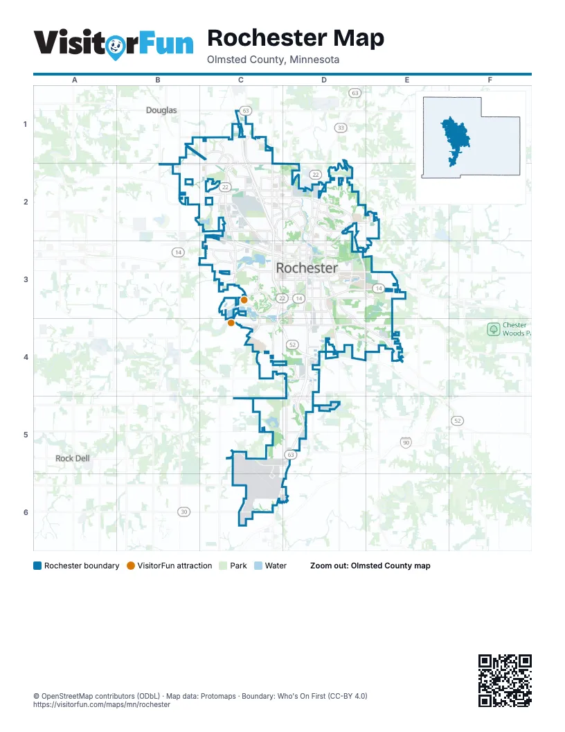
Street index of Rochester
Each street on the sheet and the grid squares it crosses.
- South Broadway AvenueD3, D4, D5, C6, D6
- West Circle Drive NorthwestC2, C3
- 55th Street NorthwestB2, C2, D2
- East Circle Drive NortheastD2, D3
- 12th Street SoutheastD3
- Salem Road SouthwestC3
- Broadway Avenue NorthD2, D3
- 37th Street NorthwestC2, D2
- Civic Center Drive NorthwestC3, D3
- 2nd Street SouthwestC3, D3
- Highway 14 EastD3, E3
- Highway 30 SouthwestC5, D5
- 16th Street SouthwestC3, D3
- West Frontage Road SouthwestC3, D4
- 12th Street SouthwestC3, D3
- 30th Avenue SoutheastD3, E4
- North Broadway AvenueD3
- West Circle Drive SouthwestC3
- 48th Street NortheastD2
- 37th Street NortheastD2
- 75th Street NorthwestC1
- Highway 63 SouthC6
- County Road 16D5
- 17th Avenue SouthwestC3
- East Frontage Roadd SouthwestC3
- 2nd Street SouthD3
- 18th Avenue NorthwestC1, C2, C3
- 19th Street NorthwestC2, D2
- 7th Street NorthwestC3, D3
- Valleyhigh Drive NorthwestC2, C3
- 11th Avenue SoutheastD3, D4
- Marion Road SoutheastD3, D4, E4
- West Frontage Road NorthwestC2, C3
- Viola Road NortheastD2, E2, D3
- East Frontage Road NorthwestC2, C3
- 48th Street SouthwestC5, D5
- 41st Street NorthwestC2, D2
- 11th Avenue SouthwestD3, D4, D5
- Valleyhigh Road NorthwestB2, C2
- College View Road EastD3, E3
- 3rd Avenue SoutheastD3, D4
- Elton Hills Drive NorthwestC2, D2
- West River Parkway NorthwestD2
- 11th Avenue NorthwestD2, D3
- Bamber Valley Road SouthwestC3, C4
- 4th Avenue NorthwestD2, D3
- Country Club Road WestC3
- 3rd Avenue SouthwestD3, D4
- 4th Street SouthwestC3, D3
- 4th Avenue SouthwestD3, D4
- 4th Street SoutheastD3
- 11th Avenue NortheastD2, D3
- 3rd Avenue NorthwestD2, D3
- 7th Street NortheastD3
- 16th Street SoutheastD3
- 15th Avenue SoutheastD3
- 14th Street NortheastD3
- 48th Street SoutheastD5
- Assisi Drive NorthwestC2, D3
- 13th Avenue SoutheastD3
- 2nd Street SoutheastD3
- 60th Avenue NorthwestB2
- Civic Center Drive NortheastD3
- West River Road NorthwestD2
- Country Club Road SouthwestC3
- Civic Center Drive SoutheastD3
- 48th Street SouthD5
- County Road 47D5
- 16th Street SouthD3
- 7th Street NorthD3
- 4th Street SouthD3
- 50th Avenue NorthwestC1, C2, C3
- 20th Street SoutheastD4, E4
- 18th Avenue SouthwestC3, C4
- 65th Street NorthwestB1, C1
- Mayowood Road SouthwestC3, D3, C4, D4
- Commercial Drive SouthwestD4, D5
- 40th Street SouthwestC4, D4
- Saint Bridget Road SoutheastD4, D5
- 13th Avenue NorthwestC2, D2, C3
- Maine Avenue SoutheastD4, D5
- 3rd Street NorthwestC3, D3
- 8th Avenue SoutheastD3, D4
- 15th Avenue NorthwestC2, C3
- Eastwood Road SoutheastD3, E3
- Superior Drive NorthwestC2
- 19th Avenue NorthwestC2, C3
- 16th Avenue NorthwestC2, C3
- Pinewood Road SoutheastD4, E4
- College Parkway SoutheastD3
- 17th Avenue NorthwestC2, C3
- 26th Street NorthwestC2, D2
- Badger Hills Drive NorthwestC2
- Fox Valley Drive SouthwestC3
- 6th Street SouthwestC3, D3
- East River Road NortheastD2
- 9th Avenue NorthwestD2, D3
- 48th Street NorthwestC2
- 31st Avenue SouthwestC5, C6
- Towne Club Parkway SoutheastD3, E3
- West Center StreetC3, D3
- College Drive SoutheastD3
- 28th Street SoutheastD4, E4
- 90th Street SouthwestC6
- 40th Avenue SoutheastE3, E4
- 14th Street NorthwestC3, D3
- 10th Street NorthwestC2, C3, D3
- Northern Valley Drive NortheastD2
- Rocky Creek Drive NortheastD2
- 25th Street SoutheastD4, E4
- Memorial Parkway SouthwestD3
- Essex Parkway NorthwestC2, D2
- 21st Avenue NorthwestC2
- Fairway Drive NorthwestC1, C2
- 60th Street SouthwestC5, D5
- 10th Avenue SouthwestD3, D4, D5
- 36th Avenue SoutheastE3, E4
- Northern Heights Drive NortheastD2
- Bandel Road NorthwestC1, C2
- 36th Street SouthwestC4, D4
- East Center StreetD3
- 7th Avenue SouthwestD3, D4
- 20th Street SouthwestC4, D4
- 12th Avenue NorthwestC2, D2, C3, D3
- 9th Avenue SouthwestD3, D4
- 37th Avenue NorthwestC1, C3
- 19th Avenue SoutheastD3, D4
- 6th Avenue SouthwestD3
- 23rd Avenue SouthwestC3
- 36th Avenue NorthwestC2, C3
- 14th Avenue SouthwestC3, C4, D4
- Alpha Parkway NorthwestC2
- 4th Street NorthwestC3, D3
- Overland Drive NorthwestC1
- 22nd Avenue NorthwestC1, C2
- 33rd Street NorthwestC2, D2
- 6th Avenue NorthwestD2, D3
- Wilder Road NorthwestC2, C3
- 8 1/2 Street SoutheastD3
- 10th Street NortheastD3
- East Frontage Road SouthwestC3, D3
- East Frontage Road SoutheastD3, D4
- West Silver Lake Drive NortheastD3
- 10th Avenue NortheastD2, D3
- 14th Avenue NortheastD3
- 11th Street SouthwestC3, D3
- Commerce Drive NorthwestC2
- 9th Street NortheastD3
- 30th Street SoutheastD4, E4
- Cascade Street NorthwestC2, D2
- 6th Street SoutheastD3
- 80th Street SouthwestC6
- Members Parkway NorthwestC2
- Villa Road NorthwestC1
- 28th Street NorthwestC2, D2
- 17th Street NortheastD2
- 43rd Street NorthwestC2
- 15th Avenue NortheastD3
- 31st Avenue NorthwestC2
- 9th Street SoutheastD3
- 44th Avenue NorthwestC1, C2, C3
- 40th Street SoutheastD4
- Savannah Drive NorthwestC1
- Chateau Road NorthwestC1, C2
- 31st Street NorthwestC2, D2
- 3rd Avenue NortheastD2, D3
- Zumbro Drive NorthwestD2
- Northern Hills Drive NortheastD2
- Wood Lake Drive SoutheastD4
- Scott Road NorthwestC2
- Park Lane SoutheastD3
- 5th Street NortheastD3
- 24th Avenue SoutheastD3, D4
- Willow Heights Drive SouthwestD4
- Manor Park Drive NorthwestC3
- Technology Drive NorthwestC2
- West Frontage Road Highway 52 NorthwestC2
- Energy Parkway NortheastD3
- Fox Knoll Drive SouthwestC3
- 31st Street NortheastD2
- Stadium View Place SoutheastD3
- 16th Avenue SouthwestC3
- Marketplace Drive NorthwestC2
- 28th Avenue SouthwestC4
- Prairie Vista Drive NorthwestC1
- Maine Street SoutheastD4
- Nottingham Drive NorthwestC2
- L C Drive SouthwestD5
- Gameday Drive SoutheastD4
- Helgerson Drive SouthwestC5
- 24th Street NortheastD2
- 18th Avenue NortheastD3
- Hadley Valley Road NortheastD2
- 13th Street NorthwestD3
- Teton Lane NortheastD2
- Fairway Place NorthwestC2
- Felty Avenue SoutheastE3
- 40th Street SouthD4
- Superior Road NorthwestC2
- Right turn laneC2
- 50th Avnue NorthwestC2
- 6th Avenue Southwest (CLOSED)D3
- Center StreetD3
- UCR Dr SoutheastD3
- 9th Avenue SoutheastD3, D4
- Frontage RoadD2, C3, D5
- 2nd Street NorthwestC3, D3
- 1st Street NorthwestC3, D3
- 7th Avenue SoutheastD3
- Stone Point Drive NortheastD2
- 51st Street NorthwestB2, C2
- 6th Avenue SoutheastD3
- 5th Street NorthwestC3, D3
- 25th Avenue NorthwestC1, C2
- 14th Avenue NorthwestC2, C3
- 4th Avenue SoutheastD3
- 1st Street SouthwestC3, D3
- North Frontage Road NorthwestC2, C3
- Merrihills Drive SouthwestC4
- 5th Avenue SouthwestD3, D4
- 6th Street NorthwestC3, D3
- 1st Avenue SoutheastD3, D4
- 22nd Street NorthwestC2
- 10th Avenue SoutheastD3, D4
- 9th Street NorthwestC3, D3
- 55th Avenue NorthwestB1, B2
- Woodland Drive SouthwestC3
- Stonehedge Drive NortheastD2
- 5th Avenue NorthwestD2, D3
- 56th Street NorthwestB1, C1
- 5th Street SouthwestC3, D3
- Shannon Oaks Boulevard NortheastE2
- 5th Avenue SoutheastD3
- 3rd Street SouthwestC3, D3
- Shetland Drive NorthwestC1
- 8th Street NorthwestC3, D3
- 23rd Avenue NorthwestC1, C2
- 7th Street SouthwestC3, D3
- Skyline Drive SouthwestC3
- The Springs at South BroadwayD4
- 2nd Avenue NorthwestD2, D3
- 10th Street SoutheastD3
- 1st Avenue SouthwestD3, D4
- 18th Street SoutheastD3, D4, E4
- 50th Street NorthwestC2
- 9th Avenue NortheastD2, D3
- 15th Street SoutheastD3
- Salem Point Drive SouthwestC3
- Scenic View Drive SouthwestC5
- 7th Avenue NorthwestD2, D3
- 19th Avenue SouthwestC3
- 1st Avenue NortheastD2, D3
- 21st Street NortheastD2, E2
- 13th Avenue NortheastD2, D3
- 8th Avenue SouthwestD3
- 17th Street SoutheastD3, D4
- 28th Street SouthwestC4, D4
- 57th Street NorthwestC1
- Century Valley Road NortheastD2, E2, D3, E3
- Fieldstone Road SouthwestC4
- Institute Road SouthwestC4
- Baihly Hills Drive SouthwestC3
- Access West IBM SiteC2
- Leqve Drive SouthwestC5, C6
- 20th Street NorthwestC2, D2
- Hadley Hills Drive NortheastD2
- 12th Street NorthwestC3, D3
- Nicklaus Drive NorthwestC2
- 24th Street NorthwestC2, D2
- Granite Drive NorthwestC1
- Tee Time Road SoutheastD3
- 19th Street SoutheastD4, E4
- 11th Street SoutheastD3
- Century Hills Drive NortheastD2
- 26th Avenue NorthwestC1, C2
- Access IBMC2
- 21st Street SoutheastD4, E4
- Manor Brook Drive NorthwestC3
- 8th Avenue NorthwestD2, D3
- 7th Avenue NortheastD2, D3
- Valley Drive NorthwestC3
- 15th Avenue SouthwestC3, C4
- Ponderosa Drive SouthwestC4
- Kenosha Drive NorthwestC2
- 8th Street SouthwestC3, D3
- Crossroads Drive SouthwestD3
- 15th Street NortheastD2, D3
- East Silver Lake DriveD3
- Wilshire Drive NortheastD2, D3
- Scenic Oak Drive SouthwestC5
- 16th Street NortheastD2
- 29th Street SoutheastD4, E4
- 42nd Street NorthwestC2
- Pinewood Ridge Drive SoutheastD4
- Odyssey Drive SouthwestC4
- Alberta Drive NortheastD2
- 19th Street NortheastD2
- South Pointe Drive SouthwestD5
- Chalet Drive NorthwestD2
- North Frontage RoadC2, D3
Things to do on the Rochester map
Places on the map
- Airport View Business Center
- Apache Mall
- Assisi Heights
- Assisi Hgts Forest & Orchard
- Autumn Ridge Church
- Badger Hills
- Badger Ridge Park
- Bamber Lake
- Bear Creek Park
- Broadway Commons
- Broadway Residence and Suites by Bridgestreet
- Canal Place
- Cascade Lake
- Cascade Lake Park
- Cascade Meadows Wetlands
- Century High School
- Chateau Center
- Community Behavioral Health Hospital - Rochester
- Cook Park
- Costco
- Crossroads Center
- Douglas State Trail
- Eastwood Golf Club
- Eastwood Park
- Essex Park
- Mayo Lake
- McQuillan Sports Complex
- Northern Heights Park
- Northern Hills Golf Course
- Northwest Plaza
- Quarry Hill Park
- Riverview West Park
- Rochester Golf & Country Club
- Sand & Gravel Operations
- Shoppes on Maine
- Silver Lake
- Silver Lake Park
- Willow Creek Country Club
- Willow Creek Reservoir
- Willow Creek Reservoir Park
Next to Rochester
- Douglas
- Rock Dell
© OpenStreetMap contributors, Open Database License, openstreetmap.org/copyright · Map data: Protomaps · Boundary: Who's On First (CC-BY 4.0); U.S. Census Bureau