

Minnesota map
Olmsted County map
About 166,424 people live here (Census Bureau, 2024 estimate). The sheet's index lists 300 streets; 2nd Street Southwest, 2nd Avenue Northwest and 3rd Avenue Northwest cross the most grid squares. Things to do inside the boundary: Apache Mall, Historic Mayowood and History Center of Olmsted County.
Open the map (PDF, US Letter)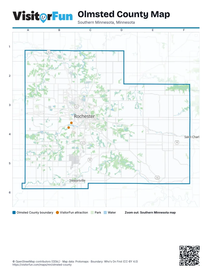
Maps inside Olmsted County
2 maps inside, from the street map of Olmsted County down.
City
Street index of Olmsted County
Each street on the sheet and the grid squares it crosses.
- South Broadway AvenueC3, C4, C5
- CLOSED FOR RECONSTRUCTIOND4
- Bus OnlyB2, B4
- American Veterans Memorial HighwayD4
- 75th Street NorthwestA2, B2, C2
- Highway 30 SoutheastD5, E5, C6, D6, E6
- Highway 30 SouthwestA5, B5, C5
- Highway 14 EastC4, D4, E4
- Salem Road SouthwestB4, C4
- 48th Street NortheastC3, D3, E3
- West Circle Drive NorthwestB3
- Broadway Avenue NorthC2, C3
- 75th Street NortheastC2, D2, E2
- 55th Street NorthwestA3, B3, C3
- East Circle Drive NortheastC3
- Highway 63 NorthC1, C2
- Highway 14B3
- Highway 247 NortheastC2, D2
- 12th Street SoutheastC4
- 2nd Street SouthwestB2, B3, C3, E4, B6, C6
- 37th Street NorthwestB3, C3
- East White Bridge RoadB1
- Highway 42E4
- Highway 30 & 74E6, F6
- 30th Avenue SoutheastC3, C4, C6
- White Bridge Road NorthwestB1, C1
- North Main StreetC5, C6
- Civic Center Drive NorthwestC3
- White Bridge Road NortheastC1, C2
- 1st Street EastC6
- 12th Street SouthwestB2, C4
- 16th Street SouthwestC4
- State Highway 30A5
- West Frontage Road SouthwestC3, C4
- Highway 42 SoutheastE3, E4
- North Broadway AvenueC3
- 37th Street NortheastC3, E3
- West Circle Drive SouthwestB3, B4
- Highway 30A5, E6
- Highway 63 SouthC5
- South Main StreetC6
- Main Street NorthF4, E6
- Main Street Northwest / Main Street NorthE6
- Main Street NorthwestB2, E6
- County Road 16C5
- Highway 42 NortheastE3
- County Road 33C2
- 17th Avenue SouthwestC3
- White BridgeC1
- United States Highway 63C6
- East Frontage Roadd SouthwestC3
- State Highway 247D2
- 2nd Street SouthC3
- County Road 3 SouthwestB3, A4, B4, A5, A6
- County Road 5 NorthwestA1, B1, A2, A3
- Viola Road NortheastC3, D3, E3
- 60th Avenue SouthwestB3, B4, B5, B6
- County Road 3 NorthwestA1, A2, B2, B3
- County Road 10 SoutheastF3, F4, E5, F5, E6
- 18th Avenue NorthwestC1, C2, C3
- 60th Avenue NorthwestB2, B3
- Valleyhigh Road NorthwestA3, B3
- 60th Street SouthwestA5, B5, C5
- 19th Street NorthwestB3, C3
- County Road 10 NortheastE2, E3, F3
- 11th Avenue NortheastC1, C2, C3, C6
- County Road 7 SoutheastE3, E4, E5
- College View Road EastC3, D3
- County Road 8 SouthwestB4, B5, B6
- County Road 6 SouthwestA6, B6
- 90th Avenue SouthwestA4, A5, A6
- 100th Street NorthwestA2, B2, C2
- County Road 15 SouthwestB4, B5
- Marion Road SoutheastC4, D4
- 50th Avenue SoutheastD3, D4, D5
- 55th Avenue NortheastD2, D3
- Country Club Road WestB3
- County Road 1 SoutheastC5, C6
- 7th Street NorthwestA3, B3, C3
- Simpson Road SoutheastC4, C5
- Bamber Valley Road SouthwestB4
- 11th Avenue NorthwestC2, A3, C3, B5, B6
- 3rd Avenue SoutheastC3, C4, C5, C6
- 2nd Avenue NorthwestB1, B2, A3, C3, C5, C6
- 11th Avenue SoutheastC3, C4
- Valleyhigh Drive NorthwestB3, C3
- 50th Street SouthwestA4, B4
- County Road 9D3, E3
- 11th Avenue SouthwestC3, C4, C5
- 14th Street NortheastA3, C3, E3
- West Frontage Road NorthwestB3, C3
- West River Road NorthwestC2, C3
- 7th Street NortheastA3, B3, C3, C6
- East Frontage Road NorthwestB3, C3
- 48th Street SouthwestB4, C4
- 41st Street NorthwestB3, C3
- 6th Street SouthwestB2, C3, B6, C6
- 3rd Avenue NorthwestB1, C1, C2, A3, C3, C6
- County Road 117 SouthwestB4
- County Road 150 SouthwestA4
- 3rd Avenue SouthwestB2, A3, C3, C4, C6
- 4th Street SouthwestB3, C3, E4, C6
- 45th Street SoutheastC4, D4
- 4th Avenue NorthwestA3, C3
- Elton Hills Drive NorthwestC3
- County Road 17 SouthwestA4
- County Road 26 SouthwestA5
- West River Parkway NorthwestC3
- 4th Street SoutheastB2, C3, E4, C6
- State Highway 74F5, F6
- 4th Avenue SouthwestB2, C3, C4, C6
- 2nd Street SoutheastB2, C3, E4, C6
- 16th Street SoutheastC4
- 15th Avenue SoutheastC3, C4
- 48th Street SoutheastC4
- County Road 47C4
- Assisi Drive NorthwestC3
- Chatfield Street SouthF4
- 13th Avenue SoutheastC3, C4
- County Road 10F4
- County Road 1C5
- Civic Center Drive NortheastC3
- County Road 7E4
- Chatfield Street NorthF4
- Country Club Road SouthwestB3
- County Highway 6 SouthwestB6
- Civic Center Drive SoutheastC3
- 100 Street NorthwestB2
- 48th Street SouthC4
- 600th StreetA3
- County Highway 1C6
- 16th Street SouthC4
- 7th Street NorthC3
- 4th Street SouthC3
- 10th Street SoutheastA1, C4, D4, E4, F4, C6
- 70th Avenue NortheastD1, D2, D3
- 65th Street NortheastC2, D2, E2, C3
- 40th Street SoutheastC4, D4, E4
- 20th Street SoutheastC4, D4, E4
- County Road 9 NortheastE3, F3
- 85th Street NorthwestA2, B2, C2
- 80th Street SouthwestA5, B5
- 110th Avenue SouthwestA4, A5, A6
- 65th Street NorthwestB2, C2, B3
- County Road 129 SoutheastD4, E4, F4
- 55th Street SoutheastC4, D4, E4, D5, E5
- County Road 16 SoutheastC5, D5
- County Road 2 NortheastE3, F3
- 25th Street SoutheastC4, E4, F4
- 90th Avenue SoutheastD4, D5, D6
- 30th Street SoutheastC4, D4, E4
- County Road 142 SoutheastE4, F4
- County Road 105 NorthwestA2, A3
- 50th Avenue NorthwestB2, B3
- 40th Street SouthwestA4, B4, C4
- 80th Avenue SouthwestB4, B5, B6
- County Road 19 SoutheastD5, D6
- County Road 30 SoutheastF5
- New Haven Road NorthwestA1, B1, B2
- County Road 21 NortheastC2, D2
- Hadley Valley Road NortheastD2, C3, D3
- County Road 20 SoutheastC5, C6
- 20th Street NortheastA3, B3, C3, C5
- 10th Avenue NortheastA3, C3, C6
- County Road 11 NortheastD1, D2
- County Road 7 NortheastE3
- 14th Street NorthwestB3, C3
- 31st Avenue SouthwestB4, B5
- 20th Street SouthwestB4, C4
- Saint Bridget Road SoutheastC4, C5
- County Road 32 SoutheastE4, E5
- 115th Street NorthwestA2, B2, C2
- 65th Avenue SoutheastD3, D4, D5, D6
- County Road 115 SouthwestB5, B6
- County Road 25 SouthwestA4, B4
- 19th Street SoutheastC4, D4, E4
- 280th AvenueA3, A4
- 15th Avenue NortheastA3, C3, C5, C6
- County Road 5 SouthwestA3, A4
- Mayowood Road SouthwestB4, C4
- 60th Avenue SoutheastD4, D5, D6
- 10th Street NorthwestA3, B3, C3, B6, C6
- County Road 126 SouthwestA5, B5
- County Road 29 SoutheastF4
- Chester Road SoutheastD4
- 4th Street NorthwestB1, A3, B3, C3
- West Center StreetB2, C3
- County Road 131 NorthwestB1, B2
- 13th Avenue NorthwestC2, C3
- 4th Street NortheastB1, A3, B3, C3, C6
- 6th Street SoutheastB2, C3, E4, F4, C6
- 18th Avenue SouthwestC3, C4
- County Road 158 NorthwestB2, B3
- East River Road NortheastC3
- Commercial Drive SouthwestC4
- White Pines Road SoutheastB1
- County Road 24 NortheastD2, E2, D3
- 3rd Street NorthwestA3, B3, C3, C6
- 5th Avenue SoutheastC3, C4, F4, C6
- 20th Street NorthwestA3, B3, C3, B5, C5
- 2nd Avenue SouthwestB2, A3, C3, C4, C6
- 19th Avenue SoutheastA1, C3, C4, F4
- 19th Avenue NorthwestA3, C3
- Minnesota Avenue SouthB2
- 9th Avenue NorthwestB2, A3, C3
- 40th Avenue SoutheastC3, C4
- 5th Street NorthwestB1, B3, C3
- Maine Avenue SoutheastC4
- Lake Shady Avenue SouthB2
- 8th Avenue SoutheastC3, C4
- 15th Avenue NorthwestC3
- Eastwood Road SoutheastC4
- Superior Drive NorthwestB3
- 90th Street SouthwestB5, C5
- 14th Avenue NorthwestC1, C2, C3
- 16th Avenue NorthwestC2, C3
- County 24D2, E2
- 2nd Avenue NortheastB1, B2, A3, C3, C5, C6
- East Center StreetB2, C3
- 7th Avenue SouthwestA1, B2, C3, C4, B6
- 13th Street NorthwestA3, C3
- 36th Avenue SoutheastC3, C4
- Pinewood Road SoutheastC4
- College Parkway SoutheastC3
- 5th Street NortheastB1, A3, C3, E4, C6
- 31st Avenue NorthwestB2, B3
- 23rd Avenue SouthwestB3, B4, B6
- 17th Avenue NorthwestC3
- Wazuweeta Road SoutheastB1
- Power Dam Road NorthwestB1
- 10th Avenue SoutheastA3, C3, C4
- 12th Avenue NorthwestC3, B5
- 44th Avenue NorthwestB1, B3
- 26th Street NorthwestB3, C3
- 6th Avenue SouthwestC3, C4, C6
- 3rd Avenue NortheastA3, C3, C5, C6
- 5th Street SouthwestB2, B3, C3, E4
- Badger Hills Drive NorthwestB3
- Riverview Road SoutheastB1
- Fox Valley Drive SouthwestB4, C4
- 48th Street NorthwestB3, C3
- 8th Street SoutheastA1, C3, E4, F4, C6
- Towne Club Parkway SoutheastC4
- College Drive SoutheastC3, C4
- 28th Street SoutheastC4
- Frontage Road NortheastA3, C6
- County Road 140 SoutheastC5, D5
- 9th Avenue SouthwestA1, C3, C4
- Frontier Road SoutheastA3
- 9th Street NortheastA3, C3
- Prairie Vista Drive NorthwestB2
- 55th Street NortheastC3, D3, E3
- 12th Avenue NortheastA3, C3, C6
- Northern Valley Drive NortheastC3
- Rocky Creek Drive NortheastC3
- Memorial Parkway SouthwestC4
- Essex Parkway NorthwestC3
- 21st Avenue NorthwestC3
- Fairway Drive NorthwestB2, B3
- 6th Avenue NorthwestA3, C3, C6
- 10th Avenue SouthwestC3, C4, C5
- Bandel Road NorthwestB2, B3
- County Road 13 SouthwestA1
- Northern Heights Drive NortheastC3
- 36th Street SouthwestC4
- Frontage Road NorthwestA3
- 10th Street NortheastA3, C3
- 37th Avenue NorthwestB2, B3
- Lake Shady Avenue NorthB1, B2
- 9th Street SoutheastC4, C6
- 36th Avenue NorthwestB3
- 14th Avenue SouthwestC3, C4
- Alpha Parkway NorthwestB3
- County Road 34A3, B3
- Overland Drive NorthwestB2, B3, C3
- 22nd Avenue NorthwestB3, C3
- County Road 105A3
- 55th Street SouthwestA4, B4
- County Road 106 SoutheastC6
- 52nd Street SouthwestB4
- 33rd Street NorthwestC3
- Wilder Road NorthwestB3
- 8 1/2 Street SoutheastC4
- 5th Street SoutheastB2, C3, E4, C6
- East Frontage Road SouthwestC3, C4
- East Frontage Road SoutheastC4
- County Road 18 NorthwestB1
- West Silver Lake Drive NortheastC3
- 14th Avenue NortheastC3
- 11th Street SouthwestC4
- Commerce Drive NorthwestB3
- Eyota Street EastF4
- Cascade Street NorthwestC3
- Members Parkway NorthwestB3
- Burr Oak Avenue NortheastE6
- Villa Road NorthwestB3
- 28th Street NorthwestB3, C3
- 17th Street NortheastC3
- 43rd Street NorthwestB3, C3
- Center Avenue NorthE4
Things to do on the Olmsted County map
Places on the map
- Apache Mall
- Assisi Heights
- Bamber Lake
- Bear Cave Park
- Bear Creek Park
- Broadway Commons
- Byron
- Cascade Lake
- Cascade Lake Park
- Cascade Meadows Wetlands
- Cascade Township
- Chester Lake
- Chester Woods
- Chester Woods Park
- Douglas State Trail
- Dover
- Dover Township
- Driftless 18
- Eastwood Golf Club
- Eastwood Park
- Elmira Township
- Essex Park
- Eyota
- Eyota Township
- Farmington Township
- Gamehaven Reservoir
- Gamehaven Reservoir Park
- Gamehaven Scout Camp
- Haverhill Township
- High Forest Township
- Kalmar Landfill
- Kalmar Reservoir
- Kalmar Reservoir (KR-7) Park
- Kalmar Township
- Lake Shady (Former)
- Lake Zumbro
- Marion Township
- Mayo Lake
- Mayowood Corridor County Park
- Mayowood Lake
Next to Olmsted County
- Saint Charles
© OpenStreetMap contributors, Open Database License, openstreetmap.org/copyright · Map data: Protomaps · Boundary: Who's On First (CC-BY 4.0); Quattroshapes (CC BY 2.0)