

Minnesota map
Sauk Rapids map
About 13,832 people live here (Census Bureau, 2024 estimate). The sheet's index lists 204 streets; 10th Avenue Northeast, Mayhew Lake Road Northeast and Industrial Boulevard cross the most grid squares. Also on it: Mayhew Creek Park, Benton County Fairgrounds and Municpal Park.
Open the map (PDF, US Letter)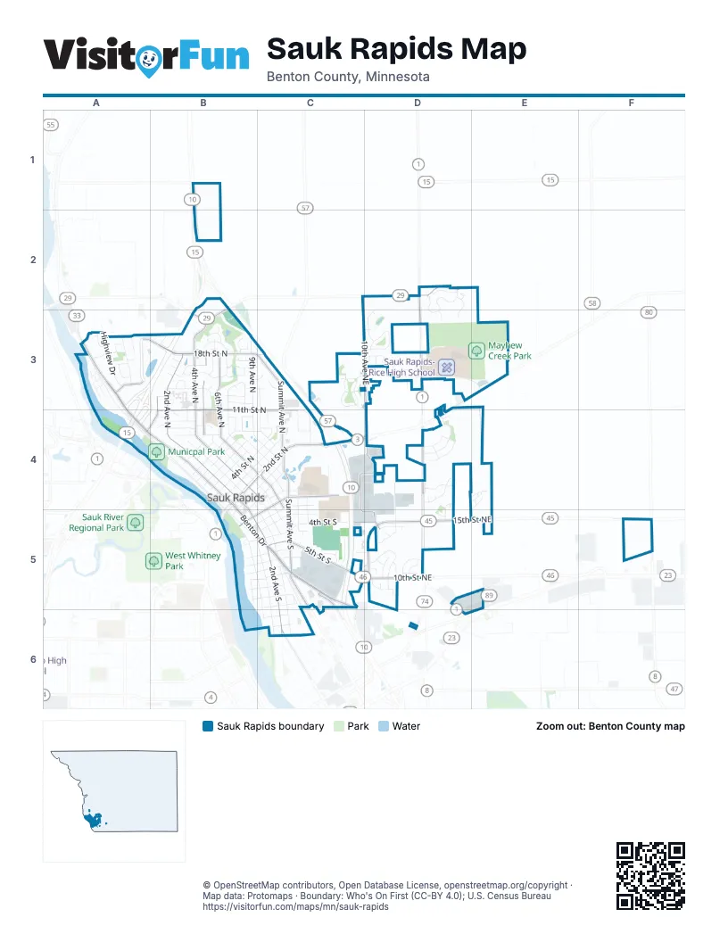
Street index of Sauk Rapids
Each street on the sheet and the grid squares it crosses.
- 10th Avenue NortheastC2, C3, D3, D5
- 34th Street NortheastD2
- 35th Street NortheastD2, B3
- Mayhew Lake RoadD2
- Mayhew Lake Road NortheastD2, D3, D4, D5
- Old Creek Place NortheastD2
- Old Creekway NortheastD2, D3
- Old Stone Way NortheastD2, D3
- Orchard Avenue NortheastD2, D3
- 18th Street NorthA3, B3
- 18th Street NorthwestA3
- 1st Avenue NortheastA3
- Apple StreetA3
- Benton Drive NorthA3, A4
- Benton Oaks CourtA3
- Benton Oaks DriveA3
- Circle Court NorthwestA3
- Circle Drive NorthwestA3
- Cottonwood AvenueA3
- East Highview CourtA3
- East Highview DriveA3
- Garden AvenueA3
- High CourtA3
- High DriveA3
- Highview DriveA3
- Maple AvenueA3
- North Benton DriveA3, A4, B4
- North Highland DriveA3
- Oak DriveA3
- Oak Pond DriveA3, B3
- Peach StreetA3
- Pear StreetA3
- Plum StreetA3
- Ridge RoadA3
- Spruce AvenueA3
- West Highview DriveA3
- 11 1/2 Street NorthB3
- 12th Street NorthB3
- 13th Street CircleB3
- 13th Street NorthB3, C3
- 14th Avenue EastB3
- 15th Street CourtB3
- 15th Street NorthB3
- 16th Street CourtB3
- 16th Street NorthB3
- 17th Street CourtB3
- 1st Avenue NorthB3, A4, B4
- 2nd Avenue NorthB3, B4, B5
- 4 1/2 Avenue NorthB3, B4
- 4th Avenue NorthB3, B4, C4
- 5th Avenue NorthB3, B4, C4
- 6th Avenue NorthB3, B4, C4
- 7th Avenue NorthB3, B4, C4
- 8th Avenue NorthB3, B4, C4
- 9th Avenue NorthB3, B4, C4
- Allisons MeadB3
- Arbor WayB3, C3
- Avian ParkB3
- Eastern Star CircleB3
- Eastern Star LoopB3
- Erickson CourtB3
- Garden PlaceB3
- Havens MoorB3
- Killinger CircleB3
- Martini DriveB3
- MN Highway 15B3
- Oak CourtB3
- Prairie LaneB3
- Rosewood LaneB3
- Schooners EndB3
- Star DriveB3
- Summit Avenue NorthB3, C3, C4
- Summit PlaceB3, C3
- Twin CourtB3
- Welsh CourtB3
- Wildflower LaneB3
- Wollar WayB3
- 10th Avenue NorthC3, C4
- Ocarina CourtC3
- Ocarina DriveC3, D3
- Olive LaneC3
- Oxen Trail NortheastC3, D3
- Quarry Road NortheastC3, C4
- Summit WayC3
- 11th Avenue NortheastD3
- 29th Street NortheastD3
- Golden Spike Road NortheastD3, C4, D4
- Old Stone Court NortheastD3
- Olympus Drive NortheastD3
- Ontario Court NortheastD3
- Onyx Way NortheastD3
- Orchid Drive NortheastD3
- Osauka Road NortheastD3, E3
- Owl Street NortheastD3
- River Avenue NorthA4, B4, B5
- 10 1/2 Street NorthB4
- 10th Street NorthB4, C4
- 11th Street NorthB4, C4
- 1st Street NorthB4, C4, B5
- 2nd Street NorthB4, C4
- 3 1/2 Avenue NorthB4
- 3rd Avenue NorthB4
- 3rd Avenue SouthB4, C5, C6
- 3rd Street NorthB4, C4
- 4th Avenue SouthB4, C4, C5
- 4th Street NorthB4, C4
- 5th Street NorthB4
- 6th Street NorthB4
- 7 1/2 Avenue NorthB4
- 7th Street NorthB4
- 8 1/2 Street NorthB4
- 8th Street NorthB4, C4
- 9 1/2 Street NorthB4
- 9th Street NorthB4
- Benton DriveB4, B5, C5
- Division StreetB4, C4, B5
- Frontier CourtB4
- Oak LaneB4
- Pearl View DriveB4
- Pleasant Ridge DriveB4
- 1/2 Street SouthC4
- 11th Avenue NorthC4
- 13th Avenue NorthC4
- 1st Street SouthC4, B5, C5
- 2nd Street SouthC4, B5, C5
- 5th Avenue SouthC4, C5
- 6th Avenue SouthC4
- 7th Avenue SouthC4
- 8th Avenue SouthC4, C5
- 9th Avenue SouthC4, C5
- Benedict DriveC4
- Cross Street SouthC4
- Industrial BoulevardC4, D4, C5, D5
- Stearns DriveC4
- Summit Avenue SouthC4, C5
- 13th Avenue NortheastD4, D5
- 18th Street NortheastD4
- Park View Lane NortheastD4
- Payton Court NortheastD4
- Peach Drive NortheastD4, E4, D5
- Pear Court NortheastD4
- Perennial Court NortheastD4
- Perennial Lane NortheastD4
- Plum Court NortheastD4
- Poplinski Place NortheastD4
- Prairie View Lane NortheastD4
- Preserve Dr NortheastD4
- Providence Place NortheastD4
- 20th Avenue NortheastE4, E5
- 10th Street SouthB5, C5
- 11th Street SouthB5, C5
- 2nd Avenue SouthB5, C5, C6
- 3rd Street SouthB5, C5
- 4th Street SouthB5, C5
- 6th Street SouthB5, C5
- 7th Street SouthB5, C5
- 8th Street SouthB5, C5
- 9th Street SouthB5, C5
- Broadway Avenue SouthB5, C5, C6
- Portage TrailB5
- River Avenue SouthB5, C5
- Water Avenue SouthB5
- 10th Street NortheastC5, D5
- 12th Street SouthC5
- 13th Avenue SouthC5
- 15th Street NortheastC5, D5, E5, F5
- 5th Street SouthC5
- Dana DriveC5
- Franklin Avenue NortheastC5
- Highway 10 NorthC5
- Industrial Drive SouthC5
- Lincoln Avenue SouthC5
- Linda LaneC5
- Nanda KnollsC5
- Park Avenue SouthC5
- Skyview DriveC5
- Agate CourtD5
- Boulder CourtD5
- Brook CourtD5
- Fieldstone DriveD5
- Garden Brook DriveD5
- Hillside CourtD5
- Hillside RoadD5
- Marcella CourtD5
- Meadow DriveD5
- Oak Crest CourtD5
- Oak Crest DriveD5
- Oak Crest LaneD5
- Peach Court NortheastD5
- Quebecor Road NortheastD5
- Stone Ridge RoadD5
- Strawberry CourtD5
- Strawberry LaneD5
- 35th Avenue NortheastF5
- 13th Street SouthC6
- 14th Street SouthC6
- 2nd Avenue NortheastC6
- 5th Avenue NortheastC6
- Raymond Avenue NortheastC6
- Riverside Drive NortheastC6
- Riverview CourtC6
- Searle Street SouthC6
- Wilson Avenue NortheastC6
- 14th Avenue NortheastD6
Places on the map
- Baseball Field
- Benedict Acres Park
- Benton County Fairgrounds
- Burger King
- Casey's General Store
- Coborn's
- Credit Union One
- Dairy Queen
- Dollar Tree
- Domino's Pizza
- Edgewood Park
- Fairview Farms Park
- Hillside
- Holiday
- Kwik Trip
- Lions Park
- Living Waters Lutheran Church ELCA
- Mayhew Creek Park
- Mie Bistro
- Motorworks Auto Repair
- Municpal Park
- Oakridge Park
- Old Capital Tavern
- Petra Lutheran Church & School WELS
- Pizza Hut
- Pleasantview Elementary
- Poor Clares Monastery of Sauk Rapides
- Sacred Heart Church
- Sauk Rapids City Office
- Sauk Rapids Fire Dept.
- Sauk Rapids Post Office
- Sauk Rapids-Rice High School
- Scenic View Park
- Shell
- Southside Park
- Speedway
- St. Cloud Financial Credit Union
- Walgreens
- Wells Fargo
- Williams Dingman Funeral Home
© OpenStreetMap contributors, Open Database License, openstreetmap.org/copyright · Map data: Protomaps · Boundary: Who's On First (CC-BY 4.0); U.S. Census Bureau















