

Minnesota map
Benton County map
About 41,881 people live here (Census Bureau, 2024 estimate). The sheet's index lists 300 streets; 105th Avenue Northeast, 85th Street Northeast and Golden Spike Road Northeast cross the most grid squares. Things to do inside the boundary: St. Cloud.
Open the map (PDF, US Letter)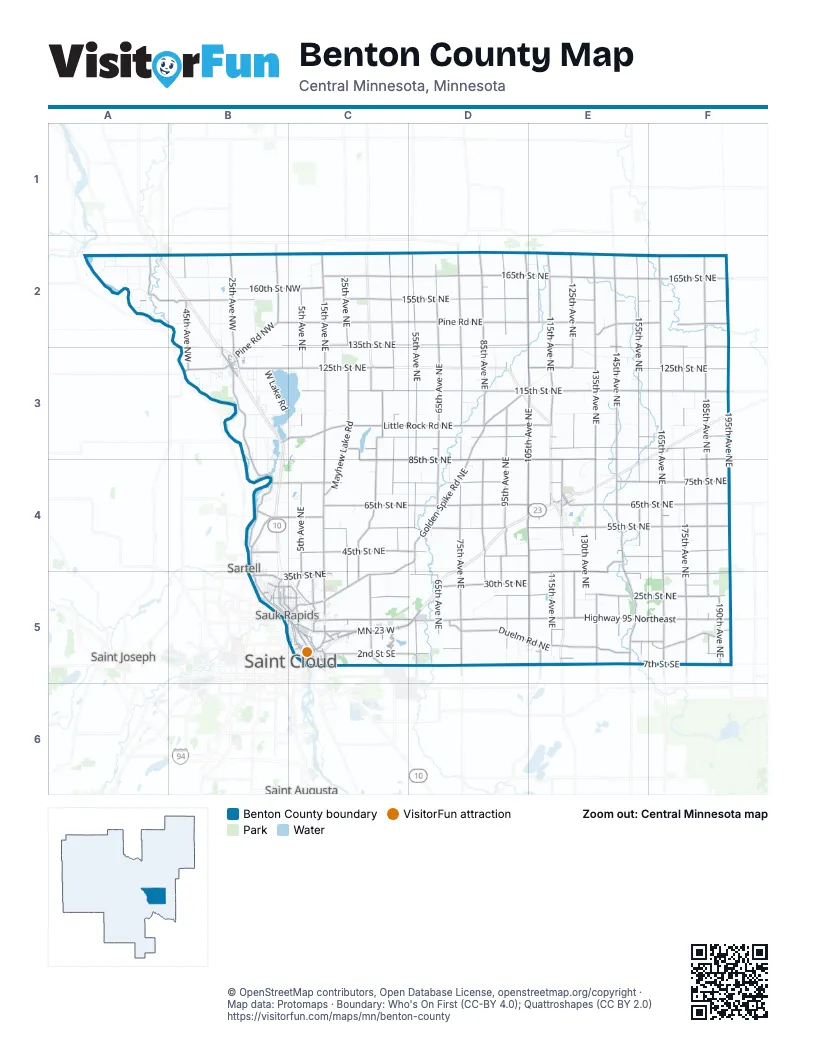
Maps inside Benton County
2 maps inside, from the street map of Benton County down.
City
Street index of Benton County
Each street on the sheet and the grid squares it crosses.
- MN Highway 15B4, B5
- US Highway 10B4
- 125th Street NortheastC3, E3, F3
- MN 23 WC5, D5
- MN 23 EC5, D5
- 3rd Street SoutheastB3, C5, E5
- Division Street NorthB2, B3
- 3rd StreetB3, C5, D5
- Granite City CrossingC5
- US-10 EC5
- Golden Spike Road NortheastD3, E3, C4, D4, C5
- Highway 95 NortheastD5, E5, F5
- 35th Street NortheastB5, C5, D5, E5, F5
- 15th Street NortheastC5, D5
- Benton Drive NorthB4, B5
- Benton DriveB5, C5
- Mayhew Lake Road NortheastC5
- East Saint Germain StreetC5
- 2nd Street NorthB5, C5
- 1st Avenue NortheastB3, C3, C4, B5
- Highway 95 EastD5, E5
- North Benton DriveB5
- 60th Street NorthwestB4
- Veterans BridgeC5
- 165th Street NortheastC2, D2, E2, F2
- 115th Street NortheastC3, D3, E3, F3
- 165th Avenue NortheastF2, F3, F4, F5
- 65th Street NortheastC4, D4, E4, F4
- 185th Avenue NortheastF2, F3, F4, F5
- 105th Avenue NortheastD2, E2, E3, D4, E4, E5
- 55th Street NortheastC4, D4, E4, F4
- 75th Avenue NortheastD2, D3, D4, D5
- 135th Avenue NortheastE2, E3, E4, E5
- 55th Avenue NortheastD2, D3, D4, D5
- Pine Road NortheastB2, C2, D2, E2
- 65th Avenue NortheastD2, D3, D4, D5
- 135th Street NortheastB2, C2, D2, E2, F2
- 85th Avenue NortheastD2, D3, D4, D5
- 95th Avenue NortheastD2, D3, D4, D5
- 145th Avenue NortheastE2, E3, E4, E5
- 75th Street NortheastB4, C4, D4, E4, F4
- 155th Avenue NortheastE2, E3, E4, E5
- 155th Street NortheastC2, D2, E2, F2
- 85th Street NortheastE3, F3, C4, D4, E4, F4
- 175th Avenue NortheastF2, F3, F4, F5
- 115th Avenue NortheastE2, E3, E4, E5
- Little Rock Road NortheastC3, D3, E3
- 15th Avenue NortheastC2, C3, C4
- 25th Street NortheastC5, D5, E5, F5
- 45th Street NortheastC4, D4, E4, F4
- 45th Avenue NortheastC2, C3, C4, C5
- 195th Avenue NortheastF2, F3, F4
- Northeast River RoadB3, B4
- 125th Avenue NortheastE2, E3, E4, E5
- 90th Street NortheastC3, D3, E3, F3, C4
- 5th Avenue NortheastC2, C3, C4, C5
- Mayhew Lake RoadC3, C4, C5
- 95th Street NortheastC3, D3, E3, F3
- 7th Street SoutheastC5, D5, E5, F5
- Duelm Road NortheastD5, E5
- Ronneby Road NortheastE4, E5
- Town Hall Road NortheastC3, C4, C5
- 25th Avenue NortheastC2, B3, C4, C5
- 2nd Street SoutheastB3, C5, D5, F5
- 30th Street NortheastD5, E5, F5
- 42nd Street NortheastD4, E4, F4
- School House Road NortheastE4, E5
- 35th Avenue NortheastC3, C5
- 125th Street NorthwestB3, C3
- 25th Avenue NorthwestB2, B3
- 145th Street NortheastE2, F2
- 45th Avenue NorthwestB2, B3
- 110th Avenue NortheastE2, E5
- 10th Street NortheastB4, C5, E5, F5
- Halfway Crossing NorthwestA2, B2
- 155th Street NorthwestA2, B2
- 160th Street NorthwestB2, C2
- 5th Avenue NorthwestB2
- 190th Avenue NortheastF5
- 60th Street NortheastB4, C4, D4, E4, F4
- Pine Road NorthwestB2, B3
- 5th Street NortheastB3, B4, C5, E5, F5
- 40th Avenue NortheastC3, C5
- 47th Avenue NortheastC4, C5
- 10th Avenue NortheastB3, C5
- 1st Street NortheastB5, C5, D5
- 4th Avenue NorthB5, C5
- 2nd Avenue NorthB5, C5
- Glendorado Road NortheastF5
- Glendorado RoadF5
- Duelm Road SoutheastE5
- Quarry Road NortheastC5
- 120th Avenue NortheastE4
- 6th Avenue NorthB5, C5
- 18th Street NorthB5, C5
- 2nd Avenue SouthC5
- 92nd Avenue NortheastD4, D5
- 11th Street NorthB5, C5
- 160th Street NortheastC2, D2
- Scenic Drive NorthwestB4
- Broadway Avenue SouthE4, C5
- Summit Avenue SouthC5
- Daisy Road NortheastE2
- 75th Avenue SoutheastD5
- Benton County 23E5
- 1st Street SouthB5, C5
- Industrial BoulevardC5
- County Highway 1C4
- Summit Avenue NorthC5
- Little Rock RoadD3, E3
- Lincoln Avenue SoutheastC5
- Frontage RoadE4, C5
- Franklin Avenue NortheastC5
- 1st Street SoutheastB3, C5, E5
- 5th Street SouthC5
- Lincoln Avenue NortheastC5
- 35th Avenue SoutheastC5
- 7th Street NortheastB3, B4, C5
- Frost Road NorthwestB4
- Wilson Avenue NortheastC5
- Norman Avenue NorthE4
- 75th Street NorthwestB4
- County Road 29B5
- Highway 10 NorthC5
- South Division StreetB3
- 14th Avenue NortheastC5
- 4 1/2 Avenue NorthB5
- Quebecor Road NortheastC5
- Wilson Avenue SoutheastC5
- 175th Avenue SoutheastF5
- Main StreetE4
- Ronneby Road SoutheastE5
- 165th Avenue SoutheastF5
- 55th Avenue SoutheastD5
- Little Rock Road NorthwestB3, C3
- 4th Street SoutheastC5
- Norman Avenue SouthE4
- Broadway Avenue NorthE4
- 4th AvenueE4
- 15th Avenue SoutheastC5
- East Division StreetC5
- County Road 235B2
- Highway 10 SouthC5
- Lincoln Avenue SouthC5
- 1st Avenue NorthB5
- West Main StreetB3
- 320th AvenueD2
- East Main StreetB3
- 18th Street NorthwestB5
- Ironwood Road NortheastF3
- 55th Avenue NorthwestA2
- 14th Avenue SoutheastC5
- 130th StreetF3
- 6th Avenue SouthC5
- 165th AvenueF5
- 21st Avenue NortheastC5
- 167 1/2 Avenue NortheastF3
- 110th Avenue SoutheastE5
- 35th AvenueC5
- 180th StreetF2
- Southwest 1st StreetB3
- 8th Avenue SoutheastC5
- County Road 23E5
- Southwest 1st AvenueB3
- 310th AvenueD2
- 15th Avenue NorthwestB2, B3, B4
- 105th Street NortheastC3, E3, F3
- 35th Avenue NorthwestB2, B3
- 130th Avenue NortheastE3, E4, E5
- West Lake RoadB3
- 130th Street NortheastD3, E3, F3
- 100th Street NortheastC3, E3, F3
- 90th Avenue NortheastD2, D3, D4, D5
- 70th Street NortheastC4, D4
- 165th Street NorthwestB2
- 170th Avenue NortheastF3, F4
- 10th Avenue NorthwestB3, B4
- 175th Street NortheastD2, E2
- Acorn Road NorthwestA2
- Quail Road NortheastC5
- Lakewood Shore Road NorthwestB3, B4
- 110th Street NortheastD3, F3
- Barley Road NorthwestA2
- Shadowwood Drive NortheastC5
- 78th Street NortheastE4
- 145th Street NorthwestB2
- 180th Avenue NortheastF3, F5
- Primrose Road NortheastD5
- 160th Avenue NortheastF2, F3
- Aspen RoadC2
- 95th Street NorthwestB3
- 65th Avenue NorthwestA2
- 47th Street NortheastE4
- Sucker Creek RoadC3
- 16th Avenue NorthwestB3, B4
- 7th Avenue NorthB5, C5
- River Avenue NorthB5
- 135th Street NorthwestB2
- 2nd Avenue NortheastB4, C4, B5, C5
- Canary Road NorthwestA2
- 22nd Avenue NortheastC2, C3, C4
- 105th Street NorthwestB3
- 70th Avenue NortheastD3, D4
- 6th Avenue NorthwestB3
- 8th Avenue NortheastB3, C3
- Finch Road NortheastE3
- Ferry Point Place NorthwestB3
- 130th Street NorthwestB3
- 3rd Avenue SouthC5
- Jonquil Road NortheastE4
- 115th Street North WestB3
- 50th Street NortheastE4, F4
- 5th Avenue NorthB5, C5
- Elk Road NortheastE3
- Old Highway 23E4
- 80th Avenue NortheastD4
- 52nd Avenue NortheastD5
- Mockingbird Road NortheastD4, E4
- 30th Avenue NorthwestB2
- 42nd Avenue NortheastC5
- 9th Avenue NorthC5
- 14th Avenue EastB5
- 23rd Street NortheastE5
- 4th Street SouthC5
- Jasmine Loop NorthwestB4
- 172nd Avenue NortheastF4
- Osauka Road NortheastC5
- 120th Street NortheastD3, E3
- Balsa RoadA2
- Gateway Drive NorthB2
- 100th Avenue NortheastD5
- West Highview DriveB5
- 10th Street NorthB5, C5
- Tee-To-Green StreetD5
- 4th Avenue NortheastB4, B5, C5
- 85th Street NorthwestC3, B4, C4
- Private DriveB2
- Riverside Drive NortheastC5
- 13th Street NortheastC5, D5
- Indian Road NorthwestB3
- 3rd Avenue NortheastB4, B5, C5
- 8th Street NorthB5, C5
- 3rd Street SouthwestB3
- 70th Avenue NorthwestA2
- River Avenue SouthB5, C5
- 3rd Street NortheastB5, C5
- 8th Street NortheastB4, C5
- 3rd Street NorthB5, C5
- 3rd Avenue NorthB5, C5
- 95th Avenue SoutheastD5
- 173rd Street NorthwestA2
- Old Stone Way NortheastC5
- 163rd Street NorthwestA2
- 13th Avenue NortheastC5
- 118th Street NorthwestB3
- 4th Street NorthB5, C5
- 4th Avenue SouthE4, C5
- Sycamore Road SoutheastE5
- Northwest Sharon PlaceB3, C3
- 4th Street NortheastB3, B5, C5
- Ocarina DriveC5
- 6th Street NorthB5, C5
- 103rd Avenue NortheastD3
- Mayflower Road NorthwestB4
- 13th Street NorthB5, C5
- 2nd Street SouthC5
- 6th Street NortheastB4, C5
- Raven Loop NortheastD5, E5
- 120th Street NorthwestB3
- Maple DriveE4
- 3rd Street SouthC5
- 8th Avenue NorthC5
- Roseanna Beach Road NorthwestB3
- 43rd Street NortheastB4, C4
- 2nd Street NortheastB5, C5
- 168th Avenue NortheastF3, F5
- 140th Avenue NortheastE2
- Dewey StreetE4
- 28th Avenue NortheastC4, C5
- 8th Avenue SouthC5
- 1st Street NorthB5, C5
- 10th Avenue NorthC5
- Penn StreetE4
- Oak Pond DriveB5
- 73rd Street NortheastE4
- 9th Avenue SouthC5
- 7th Street SouthC5
- Grand StreetE4
- Peach Drive NortheastC5
- 80th Street NortheastC4, E4
- Garden Brook DriveC5
- 2nd Avenue SouthwestB3
- Division StreetC5
- 75th Avenue NorthwestA2
- 170th Street NortheastD2, E2
- 57th Avenue NortheastD4
- 107th Street NortheastF3
- 19th Avenue NorthwestB3
- 152nd Avenue NortheastE3
- Glen StreetE4
Things to do on the Benton County map
Places on the map
- Alberta Township
- BenLacs Wildlife Management Area, Main Unit
- Benton Beach Park
- Benton County Fairgrounds
- Benton Wildlife Management Area
- Bibles Slough Wildlife Management Area
- Country Hearth
- Donovan Lake
- F Dillenburg Airport
- Foley
- Foley Community Library
- Gilman
- Gilmanton Township
- Glendorado Township
- Graham Township
- Graham Wildlife Management Area, Main Unit
- Granite City Speedway
- Granite Ledge Township
- Langola Township
- Little Rock Lake
- M J Mimbach Trailer Sales Inc.
- Mayhew Creek Park
- Mayhew Lake
- Mayhew Lake Township
- Maywood Township
- Michaelson Farm Wildlife Management Area
- Minden Township
- Municpal Park
- Rice
- Saint Cloud
- Saint George Township
- Sartell Wildlife Management Area
- Sauk Rapids
- Sauk Rapids Township
- Sauk Rapids-Rice High School
- St. Cloud Campground & RV Park
- Territory Golf Club
- Wapicada Golf Club
- Watab Township
- Wisneski Wildlife Management Area
Next to Benton County
- Saint Augusta
- Saint Cloud
- Saint Joseph
- Sartell map
- Waite Park
© OpenStreetMap contributors, Open Database License, openstreetmap.org/copyright · Map data: Protomaps · Boundary: Who's On First (CC-BY 4.0); Quattroshapes (CC BY 2.0)















