

Minnesota map
Stillwater map
About 19,386 people live here (Census Bureau, 2024 estimate). The sheet's index lists 300 streets; Manning Avenue North, Dellwood Road and Curve Crest Boulevard cross the most grid squares. Things to do inside the boundary: ArtReach St. Croix and Washington County Historical Society.
Open the map (PDF, US Letter)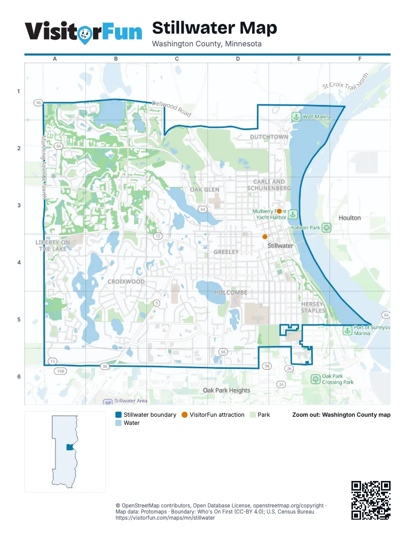
Street index of Stillwater
Each street on the sheet and the grid squares it crosses.
- Stillwater Boulevard NorthC4, B5, C5, B6
- Main Street NorthE1, E2, E3, E4
- Saint Croix Trail NorthE4, E5, F5
- Main Street SouthE4
- Manning Avenue NorthA1, A2, A3, A4, A5, A6
- Dellwood RoadA1, B1, C1, D1, E1, E2
- Curve Crest BoulevardA5, B5, C5, D5, A6, B6
- McKusick Road NorthA2, B2, C2, C3, D3
- 75th Street NorthA3, B3, A4, C4
- Greeley Street SouthD4, D5, D6
- Boutwell Road NorthA3, B3, C3, C4
- Orleans Street WestB5, C5, D5, E5
- Pine Street WestC4, D4, E4
- Olive Street WestC4, D4, E4
- Washington AvenueC5, C6
- Owens Street NorthD2, D3, D4
- 3rd Street SouthE4, E5
- Myrtle Street WestC4, D4, E4
- Laurel Street WestD3
- Stonebridge Trail NorthC2, D2
- Owens Street SouthD4
- Orleans Street East / 65th Street NorthE5
- West Myrtle StreetC4
- Myrtle Street EastE4
- Osgood Avenue NorthE5
- Boone RoadE1
- Chestnut Street EastE4
- 80th Street NorthA3
- Fairy Falls Road NorthE1
- Norell Avenue NorthC6
- Oakgreen Avenue NorthD6
- Stonebidge Trail NorthC2
- Paris Avenue NorthE5
- Stone Bridge Trail NorthC2
- 60th Street NorthB6, C6, D6, E6
- 62nd Street NorthA5, B5, E5, B6
- 2nd Street NorthE2, E3, E4
- Neal Avenue NorthB1, B2, B3
- Eagle Ridge TrailB3, C3, C4
- Northland AvenueB3, B4, B5
- White Pine WayA1, A2, B2
- 2nd Street SouthE4, E5
- 4th Street NorthD2, D3, D4, E4
- Oak Street WestC4, D4, E4
- West Frontage RoadC6, D6
- 6th Street SouthD4, E4, E5
- William Street NorthD2, D3, D4
- 5th Street SouthD4, E4, E5
- Market DriveB5, C5, B6, C6
- Willard Street WestD4, E4
- 4th Street SouthE4, E5
- Linden Street WestC3, D3, E3
- Macey WayA2, A3
- Nightingale BoulevardB4, B5
- South Holcombe StreetD4, D5
- Oak Glen DriveC1, B2, C2
- Churchill Street WestD5, E5
- Hidden Valley LaneC4, B5, C5
- 3rd Street NorthD3, E3, E4
- Amundson DriveC2, D2, C3
- Oak Glen TrailB1, C1, B2, C2
- Croixwood BoulevardB4, C4, C5
- 1st Street NorthE2, E3
- 5th Street NorthD2, D3, D4
- Rutherford RoadA4
- Interlachen DriveB4, C4
- Mulberry Street WestD4
- Sycamore Street WestD2
- Minar Avenue NorthB3
- Pine Tree TrailC4, C5
- Atwood LaneA2, B2, A3
- South Everett StreetD4, D5
- Maple Street WestD3
- Millbrook CircleA1, A2, B2
- Everett StreetD3, D4
- Hickory Street WestD3
- Maryknoll DriveB3, B4, C4
- 1st Street SouthE4, E5
- 6th Avenue SouthE4, E5
- Liberty ParkwayA4
- South Martha StreetD4, D5
- Liberty AvenueA4, A5
- Wilkins Street WestD3
- Driving Park RoadC5
- Rice Street WestD4
- Sunrise AvenueB4, B5
- North Martha StreetD3, D4
- Creekside CrossingB2, B3
- Abercrombie LaneA2, A3
- Tower Drive WestC6
- 72nd Street NorthA4, B4
- Ramsey Street WestC4, D4
- Oakridge RoadB4, C4
- Minar Lane NorthB3
- 77th Street NorthA3, B3
- 87th Street NorthA2
- 4th Avenue SouthE4, E5
- Stillwater Avenue WestD3
- Bayberry AvenueB4, C4
- 5th Avenue SouthE5
- Burlington Street EastE5
- Pioneer PlaceA4
- Meadowlark DriveC3, D3
- Marsh Street WestD5, E5
- Shelton DriveD6
- Hancock Street WestD5, E5
- Maureen LaneA1, B1
- St Croix Avenue WestC3, D3
- Industrial BoulevardD5, D6
- Brick Street SouthC4
- Settlers WayA4
- Benson Boulevard EastC5
- William Street SouthD4
- Bridgewater WayB3, B4
- Legend BoulevardA5
- Northwestern AvenueC5, C6
- Lumberjack Landing Park AccessE2, E3
- Mulberry Street EastE3
- Greeley Street NorthD3, D4
- Parkwood LaneB5
- Interlachen WayC4
- Water StreetE3, E4
- Hawthorne LaneB4
- Edgewood AvenueB4
- Barons WayA5
- Aspen Street WestD3
- Deer PathC4
- Abbot Street WestD4
- Grove Street SouthD4
- Country RoadA4
- Mid Oaks Avenue NorthB4
- Cottage DriveC5
- Hazel Street EastD2, E2
- Hazel Street WestD2
- Benson Boulevard WestC5
- Laurel Street EastD3, E3
- Fairmeadows RoadC4
- Broadway Street SouthE4
- Moore Street WestD2
- Pine Hollow PlaceA4
- Broadway Street NorthE2, E3
- 3rd Avenue SouthE5
- Bergmann DriveA5
- Harriet Street SouthD4, D5
- Sherburne Street SouthD4
- Highland RoadC5
- Schoolhouse CircleA4
- Elm Street WestD3
- Saint Croix Avenue WestD3
- Everett DriveD5
- 7th Street SouthD4, D5
- Lowell CourtB1
- Lecuyer DriveC3
- Panama Avenue NorthE5
- South Center StreetD4
- Martha StreetD2, D3
- Driftwood LaneB4, C4
- Orwell CourtE1
- Marylane Avenue NorthA2
- Echo LaneD3, C4, D4
- Morgan Avenue NorthB3
- Maryknoll Drive NorthB3
- Johnson DriveC2
- Planting GreenA4
- Birchwood DriveC3, C4
- Eban CourtA4, A5
- Sherburne Street NorthD3, D4
- North Harriet StreetD3, D4
- Judd TrailA5
- Newman TrailA4, A5
- Poplar Street WestD2
- Settlers AvenueA5
- Alder Street EastE2
- Anderson Street WestD5
- Marine CircleB5
- Homeward WayA4
- McKusick Road Lane NorthC3
- Harriet StreetD5
- West Willard StreetC4
- Saint Croix Avenue EastD3, E3
- Stillwater AvenueD3, E3
- Fairlawn DriveB4
- Reunion RoadA5
- Wilkins Street EastD3, E3
- Van Tassel DriveB2
- Cherry Street WestD3
- Churchill Street EastE5
- Hancock Street EastE5
- Marsh Street EastE5
- Summit LaneA2
- Walnut Creek DriveB3
- Dubuque Street EastE5
- Icerose LaneB5
- Oak Glen LaneC1
- Lakeside DriveE2
- McKusick Road CourtB2, C2
- Hillside LaneB4, B5
- Tuenge DriveD6
- North Everett StreetD4
- Northland TerraceB3
- Johnson CourtC2
- Wildcrest LaneB5
- Union AlleyE4
- Woodridge LaneB5
- Brewers LaneB5
- Nelson Street EastE4
- Oxboro Avenue NorthE5, E6
- Osman Avenue NorthE5
- Lookout Trail NorthE5, F5
- Neal Court NorthB1
- Morningside RoadD5
- Swenson StreetC1
- Staloch PlaceA5
- White Pine CourtB2
- Newberry Court NorthB3
- Delano WayA5
- Melville Court NorthA4
- Wildpines LaneB5
- Lookout StreetC4
- Surrey LaneC5
- Hemlock Street SouthC4
- Olive Street EastE4
- Willow Street EastE2
- Pine Street EastE4
- Seeley Street SouthC4
- Walnut Street EastE4
- Harriet DriveD5
- Walnut Street WestE4
- Towne CircleC3
- Poplar Street EastD2, E2
- Sycamore Street EastE2
- Timber WayA5
- Nena DriveC3, D3
- New England PlaceA4
- Eagle Ridge LaneC3
- Wildwood LaneC3
- North Center StreetD2, D3
- 63rd Street NorthE5
- West Elm StreetD3
- Long Lake DriveB5
- Atwood CourtA2, B2
- St Louis Street EastE5
- Tending GreenA4
- Orwell Avenue NorthE1
- Willard Street EastE4
- Heifort CourtB2
- Eban WayA4, A5
- Summit CourtA2
- Newgate Avenue NorthC1
- Marquee CourtC3
- Wright StreetA2
- 77th Street Court NorthA3
- Monterey CourtA2
- Elm Street EastE3
- Crestwood TerraceC4
- Dundee PlaceC4
- Bayberry Ave CourtC4
- Amundson LaneC2, D2
- Rainbow CourtD5
- 61st Street NorthE6
- McKusick LaneC3
- Heritage CourtA4
- Macey PlaceA2
- Fischer CircleC3, D3
- Delano DriveA5
- Lake DriveC4
- Summer Fields GreenA4
- Delano CourtA5
- West Street SouthC4
- 64th Street NorthE5
- Creekside CircleB3
- Gilbert CourtC5
- Edgewood CourtB4
- Lydia CircleC5
- Lake StreetE2
- Myrtlewood CourtC4
- Sunny Slope LaneC4, D4
- Autumn WayC5
- Nightingale CourtB5
- Tamarack CourtB4
- Liberty CourtA5
- Hanson PlaceC4
- Hidden Valley CourtB4, B5
- Victoria CourtD6
- Eagle Ridge PlaceC3
- Saddle CourtB5
- Tall Pine TrailA4
- Webster CourtA3
- Boutwell Farm RoadB3
- Hazel CourtD2
- Evergreen CourtB5
- Hill CourtB2
- Quarry LaneE4
- Ridge LaneE2
- West Poplar StreetD2
- Boutwell PlaceC3
- Macey CourtA2
- Eagle Ridge CourtB3, C3
- Chestnut Street WestD4, E4
- Hillcrest DriveE5
Things to do on the Stillwater map
Places on the map
- Acapulco Mexican Restaurant
- American Gothic Antiques
- Anastasia
- Anez Ridge Park
- Brewers Pond
- Brick Pond
- Bridge View Park
- Brown's Creek Park
- Fairview Cemetery
- Heifort Pond
- Lake McKusick
- Lakeview Hospital
- Lily Lake
- Lily Lake Elementary
- Lily Lake Park
- Long Lake
- Lumberjack Landing
- Millbrook Field West
- Millbrook Park
- Mulberry Point Yacht Harbor
- Nightingale Park
- North Lowell Park
- Northland Park
- Oak Glen Golf Course
- Ole Sawmill Marina
- Public Works Park
- Rutherfood Elementary School
- South Twin Lake
- Stillwater City Hall
- Stillwater Clinic
- Stillwater Country Club
- Stillwater Marina
- Stillwater Middle School
- Stillwater Post Office
- Stillwater Public Library
- Stillwater Public Works
- Stonebridge Elementary
- Sunrise Park
- Washington County Government Center
- Wolf Marina
Next to Stillwater
- Houlton
- Oak Park Heights
© OpenStreetMap contributors, Open Database License, openstreetmap.org/copyright · Map data: Protomaps · Boundary: Who's On First (CC-BY 4.0); U.S. Census Bureau















